batmanbrad
-
Posts
289 -
Joined
-
Last visited
Content Type
Profiles
Blogs
Forums
American Weather
Media Demo
Store
Gallery
Everything posted by batmanbrad
-
over 14 inches today so far as of the 9PM observation - likely has or will be setting a daily rainfall record since likely to have heavy rainfall right through midnight, wonder what the record was going into this storm. edit: 17 1/2 inches today as of 10PM
-
ugh the HAFS-B model has this just west of the Tampa area with SLP in the mid-920s on its 12Z run as of early morning Wed. 10/9
-
2024 Atlantic Hurricane Season
batmanbrad replied to Stormchaserchuck1's topic in Tropical Headquarters
18z GFS so far coming in weaker and further south, typical model back-and-forth continues -
small consolation to all the affected areas/population, but this one's a no-brainer - "Helene" will surely be retired so no more systems with that name will happen.
-
Hurricane Helene: Remnants Impact to Mid-Atlantic
batmanbrad replied to WxUSAF's topic in Mid Atlantic
any chance that heavy stuff near and to the west of Richmond might make it up into the DC metro area if it continues to move N or NNE this afternoon? -
I'd say even more than that; previous NHC advisory had LF around Apalachee Bay, now the cone center looks to be around Port St. Joe/Apalachicola area, I'd say 40-50 mile west shift?
-
Dr. Cowan just posted one of his excellent video discussions on the tropical tidbits site, highly recommended. Said he would have another one tomorrow.
-
HWRF (also now using Invest 97) bottoms out around 926mb at hour 78 in the eastern Gulf, heading generally NNE towards Apalachee Bay area. edit: comes ashore near the Apalachee Bay region midday 9/26 in the low/mid 930's
-
TVS signature showing up on Radarscope for that cell a bit SE of Purcelleville
- 1,696 replies
-
- 1
-

-
- severe
- thunderstorms
- (and 5 more)
-
I'm in Gaithersburg (but very close to Laytonsville), have had some good solid downpours for a while though RadarScope seems to tell me the heaviest pixels went to the west/north of me. Stuff seems to be trying to backbuild somewhat down towards the Rockville area so if it keeps training SW to NE we might get more here. Nothing really severe (even though we were warned), some moderate wind but not a whole lot of T&L so far. Edit - actually most of the heavier activity isn't in Rockville, it's east of Poolesville, just north of Darnestown and in parts of Germantown/Gaithersburg, all moving NE. Then it's a break until the next batch out near Front Royal which could get here if it holds together.
-
Tropical Storm Debby: Mid-Atlantic Impacts
batmanbrad replied to WxWatcher007's topic in Mid Atlantic
usually CWG and/or NWS Sterling produces one after the event is over; for now best would be to check the reported totals in the PNS from LWX (last one was updated around 10:30AM this morning so its totals are not yet final, especially since some of the reports are from early in the morning). -
Tropical Storm Debby: Mid-Atlantic Impacts
batmanbrad replied to WxWatcher007's topic in Mid Atlantic
looks like a couplet on the velocity scan, now east of Damascus, heading for Mount Airy area. -
Tropical Storm Debby: Mid-Atlantic Impacts
batmanbrad replied to WxWatcher007's topic in Mid Atlantic
my phone just beeped, TOR warning for central Moco (I'm in NE part of Gaithersburg, near Laytonsville). Heading towards Damascus, says the warning. -
Tropical Storm Debby: Mid-Atlantic Impacts
batmanbrad replied to WxWatcher007's topic in Mid Atlantic
EastCoast NPZ probably figures that green patch of 0.4" over in northern Delaware likely will shift over top of him in the next model runs... -
Tropical Storm Debby: Mid-Atlantic Impacts
batmanbrad replied to WxWatcher007's topic in Mid Atlantic
hmmm... since the previous couple of advisories had Debby only achieving about 50mph max up until 2nd LF, this is a bit of a surprise, wondering how much more strengthening can happen while over water. Debby still not far enough offshore to be influenced much (if at all) by the Gulf Stream? -
so far SPC isn't too bullish on the potential tornado (or even overall severe) potential for Friday, though still time for that to change with the ever-evolving track forecast updates on Debby. Much of the subforum is in MRGL risk zone for now. From the early morning D3 outlook: ...Northern Mid Atlantic... Despite the weakening trends to Debby, models suggest that the evolution of sizable clockwise-curved low-level hodographs and appreciable boundary-layer buoyancy may be maintained into at least Friday afternoon, focused in a sector to the northeast of the accelerating surface low. It appears that this may be in the process of overspreading the Chesapeake/Delmarva vicinity as daytime heating contributes to boundary-layer destabilization, before spreading northward through the northern Mid Atlantic in advance of the more inhibiting mid-level warm core. Within this environment, the evolution of a few supercell structures posing a risk for tornadoes appears possible, before this threat wanes with the loss of daytime heating Friday evening.
-
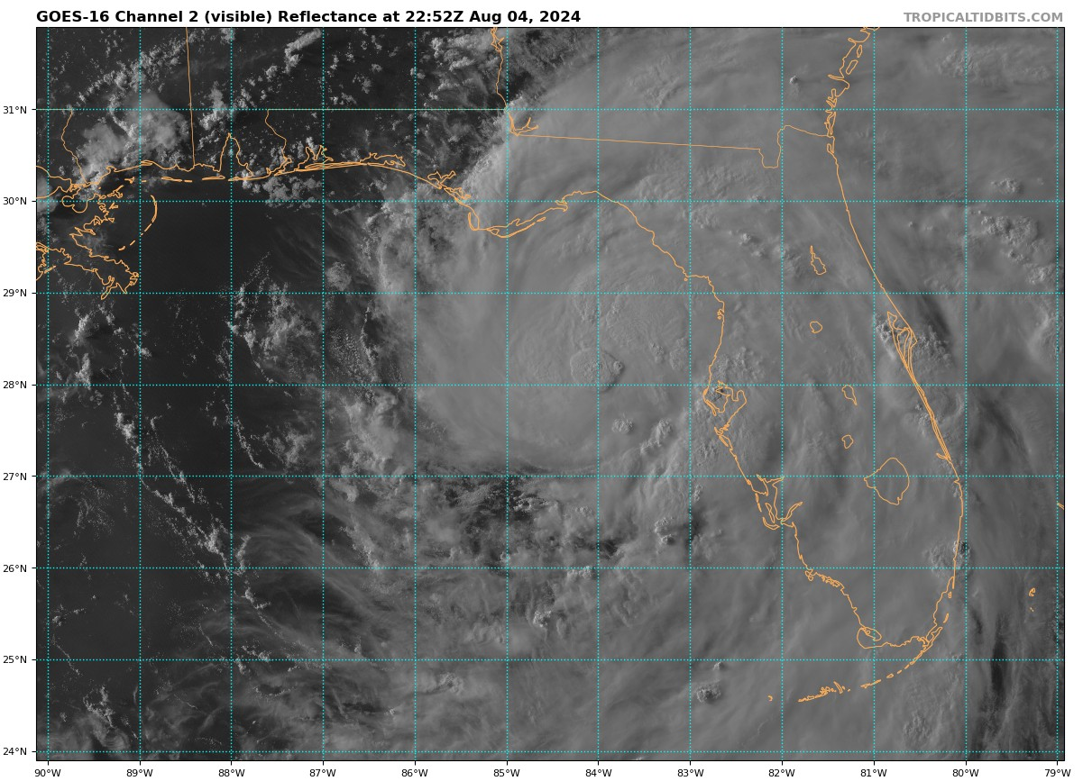
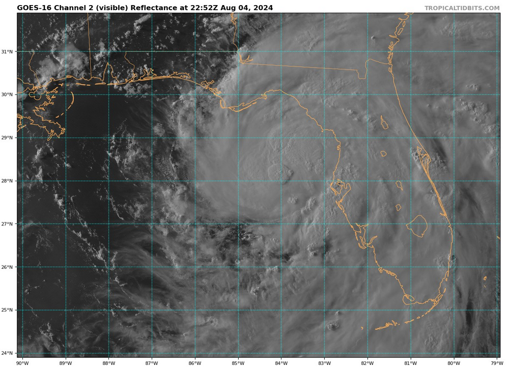
during the last 1/2 hour a big blob of convection developed just about right at 84W and just a pinch north of 28N...
-
Today's latest day 1 outlook mentions possibility of an upgrade to SLGT from MRGL in some areas of the east: ...Eastern States... A broad upper trough is present over the eastern 1/3 of the CONUS today, with slightly cooler mid-level temperatures and cyclonic flow aloft throughout the region. Morning visible satellite imagery shows strong heating across much of the Mid-Atlantic, Southeast, and TN Valley regions. This combined with a very moist surface air mass will yield steep low-level lapse rates and moderate CAPE later today, with several clusters of thunderstorms expected. Winds aloft are relatively weak, and mid-level lapse rates are not particularly steep. This suggests the bulk of this activity will be relatively disorganized. Nevertheless, given the coverage of afternoon thunderstorms and the pervasive hot/humid conditions, there is a widespread risk of gusty or occasionally damaging wind gusts this afternoon and early evening. Two areas of somewhat greater wind damage potential are from New York City region into northern VA, and from northern MS/AL into east TN. Both areas will be monitored and re-considered for upgrade to SLGT risk at 20z.
-
asking as a neophite... could the bay breeze collisions (?) be a factor in why things appear to be ramping up east of DC now?
-
yes that cell heading in the general direction of Warrenton is definitely on a strengthening trend and heading NE towards DC metro
- 1,696 replies
-
- 1
-
-
- severe
- thunderstorms
- (and 5 more)
-
looks like a bit of a westward wobble/jog in the last few frames, hard to tell if the bend back more W than WNW has started, Jamaica is hoping yes.
-
there's an okay cell that's been developing SSW of Front Royal heading ENE, nothing severe yet but it bears some watching
- 1,696 replies
-
- 1
-
-
- severe
- thunderstorms
- (and 5 more)
-
new severe thunderstorm watch for much of our western and central counties, guess they think the line to the west will hold together.
-
looks like a 5% TOR probability was added in the latest day 2 outlook from SPC for much of our area. Still SLIGHT risk though...
-
The Weekend Rule? Saturday 2/17 - The Icon Storm
batmanbrad replied to DDweatherman's topic in Mid Atlantic
hate to state the obvious but if we see Cantore anywhere near our area...