batmanbrad
-
Posts
289 -
Joined
-
Last visited
Content Type
Profiles
Blogs
Forums
American Weather
Media Demo
Store
Gallery
Everything posted by batmanbrad
-
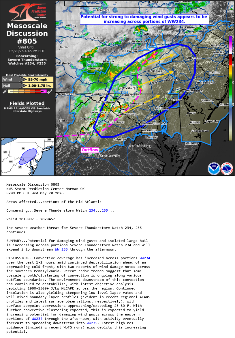
2026 Mid-Atlantic Severe Storm General Discussion
batmanbrad replied to Kmlwx's topic in Mid Atlantic
noting we've been put in a SLGT for Sunday as well by SPC -
2026 Mid-Atlantic Severe Storm General Discussion
batmanbrad replied to Kmlwx's topic in Mid Atlantic
SPC did keep the 30 wind area in their 9AM update, but did shift it a bit E/SE, otherwise few changes - as you say, we'll see if anything improves on the CAMs otherwise many of us may (again) be disappointed. -
2026 Mid-Atlantic Severe Storm General Discussion
batmanbrad replied to Kmlwx's topic in Mid Atlantic
I can see some gust front/outflow boundaries pushing out ahead of that line -
2026 Mid-Atlantic Severe Storm General Discussion
batmanbrad replied to Kmlwx's topic in Mid Atlantic
so far the line of storms coming out of WV and western MD seems to be holding together pretty well - wondering what it will do when it comes over the mountains and hits the pea soup air over us right now. If it keeps moving quickly it'll hit before we completely lose sunlight... -
currently right underneath that cell moving through the Germantown/Gaithersburg/Laytonsville area, not much T&L but big time downpour going on for the last 10-15 minutes (and counting), with more behind it this might be flash flood territory if it doesn't move out soon?
-
current radar trends are supporting the earlier thinking that most of the major activity will be north of DC...
-
2026 Mid-Atlantic Severe Storm General Discussion
batmanbrad replied to Kmlwx's topic in Mid Atlantic
SPC issued another MD for our area, seems to indicate things are continuing to ramp up somewhat:
- 630 replies
-
- 2
-

-
- severe
- thunderstorms
- (and 7 more)
-
Radarscope showing some increase in hail size, POSH's up to 40-50% on some of those cells out west including the one you mention.
-
2026 Mid-Atlantic Severe Storm General Discussion
batmanbrad replied to Kmlwx's topic in Mid Atlantic
alerted on Radarscope of an MCD issued for our area, 80% chance of a blue box coming. -
2026 Mid-Atlantic Severe Storm General Discussion
batmanbrad replied to Kmlwx's topic in Mid Atlantic
The latest forecast for me (Gaithersburg) STILL has no mention of severe for tomorrow, doesn't mention thunder at all! I checked the point-and-clicks for several other cities/counties in our area... nada. -
2026 Mid-Atlantic Severe Storm General Discussion
batmanbrad replied to Kmlwx's topic in Mid Atlantic
the next D2 outlook from SPC will be out in about 45 minutes. Since the previous discussion had mentioned upgrade possibilities existed (but not at the time for our zones), wondering if they will get any more aggressive with their probabilities. -
northern DE, NJ, most of eastern NY, and central/southern New England really score well on this GFS run.
-
kinda like the old Timex watch commercials... we need Euro to take a licking and keep on ticking... (in the proper direction). if we need 200 mile jump and it ticks the right way 25 miles at a time for 8 model runs... that'll work
-
part of afternoon AFD from Sterling - still keeping everything on the table while pointing out the 12Z shift in most (non-GFS) models towards an OTS solution: KEY MESSAGE 3...Monitoring the potential for a coastal system this weekend. We continue to monitor the potential for snow associated with a coastal low this weekend. Nearly all model solutions show a strong coastal low forming, but there`s still considerable uncertainty regarding both where that low will track, and what impacts we will experience locally. Potential outcomes range anywhere from a storm that tracks well out to sea with little impact locally, to a storm that tracks closer to the coast and produces heavy snowfall across the region. The general flow pattern forecast by models has many of the synoptic features associated with Mid-Atlantic snowstorms, with ridging along the West Coast, troughing along the East Coast, ample cold air in place at the surface, and then downstream blocking over the North Atlantic. However, the trend with incoming EPS and GEPS trended significantly downward with probabilities for snow, ultimately showing a further southeast and out to sea track. The 12z GFS shows the potential snowier solution, and GEFS probabilities for snow trended upward. Spatially speaking, probabilities are highest for snow in all guidance the further southeast you go. In our area, southern Maryland would have the greatest chance at seeing snow. It`s worth noting that the flow pattern at upper levels preceding this storm is highly complex. The primary disturbance that will ultimately contribute to the development of the system is actually located over Newfoundland currently and will rotate westward around an upper low centered over Hudson Bay, before turning southward and digging out the trough that will eventually provide the forcing for the development of the coastal low. As this disturbance turns southward, it will also be influenced by an upper low over Alaska and a building ridge over the West Coast. Given the high complexity of these interactions, it may take another 1-2 days for models to settle into a higher confidence solution, and as a result, the door is still open for large forecast shifts.
-
this kinda reminds me of the movie Spaceballs... suck, suck, suck!
-
not sure where in Gaithersburg you are, but after shoveling my driveway just as the flip to sleet occurred over here just west of Laytonsville (a few miles north of the airpark), I just went back out again and had to shovel close to 2"+ of sleet... that was much harder than the 6"+ of light powder. In a couple of hours I'll have to do it all over again with the rate of sleet falling now. At least I didn't wait until it was all over - 3-4" of sleet might be too much for this OF to get rid of.
-
Pingers made their arrival a little after 8:30AM here on the NE side of Gaithersburg, near Laytonsville. crude tape measurement on driveway was about 6.5 just as the changeover started. Sleeting quite steadily now, hoping for minimal ZR later.
-
thought of you - the JebWalk possibilites would be endless if that even just comes close to verifying...
-
take it and run with this...

-
Not likely to be before the changeover since the time says it's through 1PM on Monday... still not bad for the ICON though.
-
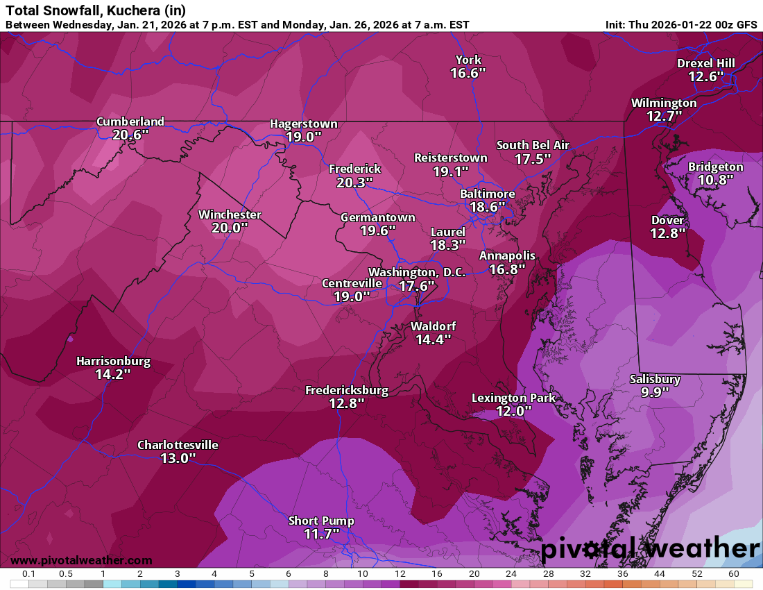
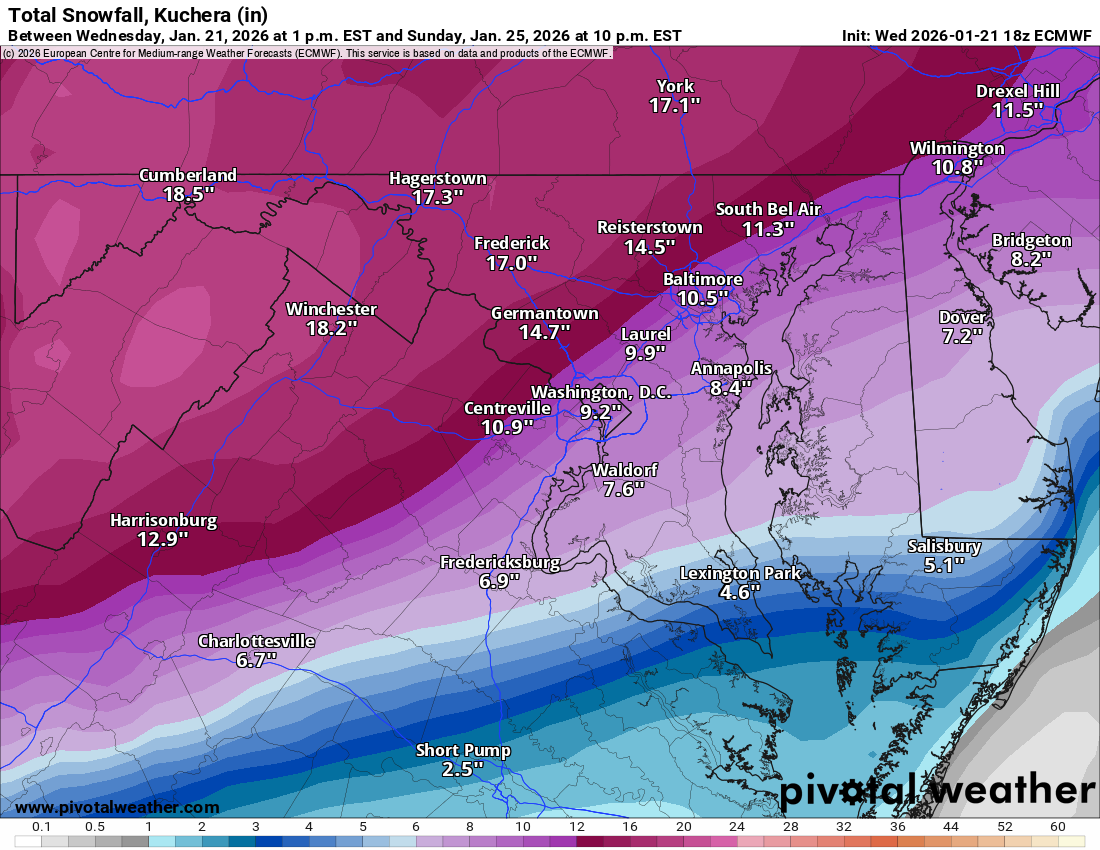
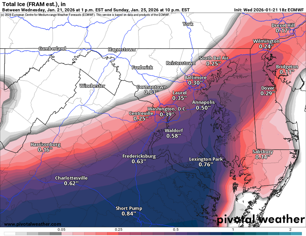
and this helps confirm MillvilleWx's thoughts on the 15-20" potential for the north and west areas that avoid most if not all of the mixing:

-
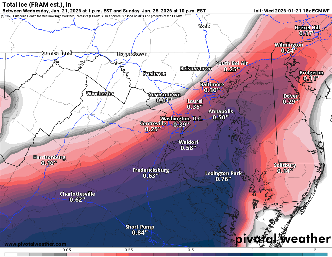
this is as of 10PM Sunday, pretty much confirms I95 as the approximate dividing line between all/nearly all snow and mixing/changeover to ice:
-
I agree, was only too happy to post his excellent read in here. Look forward to Peter's continued discussions about this storm assuming he will still be "the man" for at least some of the next several days?
-
latest discussion from WPC: Probabilistic Heavy Snow and Icing Discussion NWS Weather Prediction Center College Park MD 405 PM EST Wed Jan 21 2026 Valid 00Z Thu Jan 22 2026 - 00Z Sun Jan 25 2026 ***Major Winter Storm To Bring Significant Impacts To The South Friday Through This Weekend, Expanding Up The East Coast Saturday Night Into Sunday*** ...Southern Rockies, Southern Plains, Gulf Coast, Mid-South, Southern & Central Appalachians, & Mid-Atlantic... Days 2-3... The ingredients for the impending major winter storm begin to take shape Thursday night. A broad upper trough located off Baja California will work in tandem with a ridge axis near Mexico to direct a rich plume of tropical East Pacific moisture into the Southern Rockies and Plains. At the same time, an arctic front ushers in the coldest temperatures this season across the Great Plains with a highly anomalous dome of arctic high pressure building in over the North Central U.S.. As high pressure rushes south, easterly upslope flow induced between the high pressure to the north and lower pressure near California will cause upslope flow into the higher terrain of the CO and NM Rockies with lighter snowfall in the central High Plains. WPC probabilities show high chances (>70%) for snowfall above 9,000ft in the CO/NM Rockies through Saturday afternoon. Precipitation will blossom over much of KS, OK, and TX Friday, starting as rain across much of TX initially, but look for precipitation to transition to snow over KS, northern OK, and the TX Panhandle by Friday afternoon and evening. Farther south, strengthening low- level WAA will over-run the incoming sub-freezing layer in the lowest 2,000ft of the atmosphere from West Texas to as far east as the Mid-South. Sleet will become more prevalent over the Red River Valley, north-central AR, and into western TN, while freezing rain is the primary preip type from the TX Hill Country through the ArkLaTex and as far east as the TN Valley. Heavy sleet is possible in some of these areas with multiple inches of sleet possible through Saturday. The slow progression of the upper trough over Baja California and the bitterly cold arctic air-mass anchored over the eastern two-thirds of the CONUS is a recipe ripe for prolonged freezing rain from central TX to as far east as the southern Appalachians through 00Z Sunday. WPC probabilities show concerningly high probabilities (50-70%) for ice accumulations through 00Z Sunday over one-quarter inch. The areas of greatest concern are over the ArkLaTx, southern AR, northern LA, northern MS/AL, and southern TN where low-to-moderate chances (30-50%) exist for over one-half inch of ice. While this discussion is geared to the short term (ending 00Z Sunday) the ice in all these areas are forecast to continue through Saturday night and even into Sunday. There is great concern for extensive tree damage and power outages from central TX on east through the Mid-South and into the Southern Appalachians into Sunday. Farther north, the air-mass through the depth of the atmospheric column remains cold enough to support all snow from the Central Plains on east through the Ozarks and across northern TN and much of KY beginning Friday evening in the Plains, then into the TN/OH Valleys Saturday morning. By midday and into Saturday afternoon, periods of snow will reach the southern and central Appalachians and potentially the VA/NC Piedmont. Snowfall rates topping 1"/hr are likely in areas just north of the strongest 850-700mb FGEN zone and vertical velocities are highest in a highly saturated dendritic growth zone in the Central Plains and OH Valley. The very cold temperatures over KS on east through MS and into the OH Valley will cause SLRs to range anywhere from between 12-18:1 with the higher SLRs over KS. WPC probabilities through 00Z Sunday depict high chances (>70%) for >4" of snow over central and southern KS, much of northern OK, the TX Panhandle, and into the Ozarks of northern AR and southern MO. The best chances for >8" of snowfall reside over the Ozarks where moderate chance probabilities (40-60%) are present. Similar to the ice, the snow will by no means be over given the extensive plume of anomalous moisture emanating out of the East Pacific. By Saturday night, southerly flow out of the Gulf will continue to direct copious amounts of moisture into the eastern U.S., resulting in a highly disruptive and dangerous winter storm from the Mid-South to the Mid-Atlantic. WPC continues to issue Key Messages for this winter storm and a link to them can be found below.
-
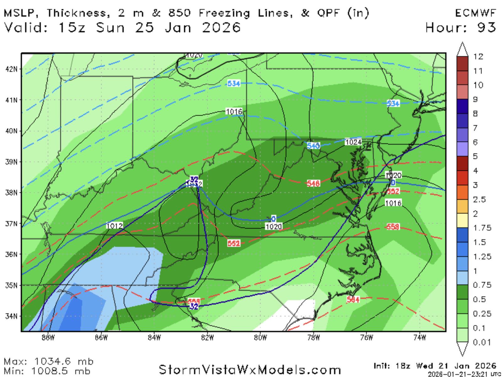
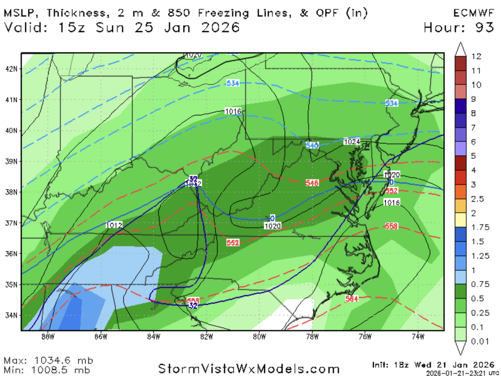
and Pivotal is still stuck at 66