nrgjeff
-
Posts
4,203 -
Joined
-
Last visited
Content Type
Profiles
Blogs
Forums
American Weather
Media Demo
Store
Gallery
Everything posted by nrgjeff
-

Fall/Winter Banter - Football, Basketball, Snowball?
nrgjeff replied to John1122's topic in Tennessee Valley
Wow @John1122 you are braver than me. I try for the stealth exit, but honestly it probably sees me. So you skip right to the be loud phase? I figure any common sense move promotes survival. If you can only remember one bear rule, just don't F* with mamabear or her cubs! -
Fall 2021 Thread (September, October, November)
nrgjeff replied to Carvers Gap's topic in Tennessee Valley
The MJO indeed stalled last week per looking at the historical index and also satellite movies. We have another Invest in the IO which could throw yet another wrench. However - key difference - is that convection is already in the West Pac. No surprise models have turned colder for the 6-15 day. -
Fall 2021 Thread (September, October, November)
nrgjeff replied to Carvers Gap's topic in Tennessee Valley
Looks like SER all winter. Just kidding! Joe Bastardi mentions 1989 and 2000 Decembers. He has not been right about anything in years. Yeah November looks really choppy as Carvers writes just above. I concur. That pattern with Bering Sea ridging allows AK to go BN heights November, mild here. However past La Nina years that pattern November have evolved into a colder Southeast US solution by December. Just not Joe B cold, lol! -
Fall/Winter Banter - Football, Basketball, Snowball?
nrgjeff replied to John1122's topic in Tennessee Valley
Reacting to bears is a good question. Smoky Mountain NP (and other national and state parks) has guidelines posted. Here is my not so complete memory. 1. Walk away from the bear (obviously). Don't run though. It'll go better just walking. If it's in your path, then a long detour is required. 2. If it charges (unlikely unless mama bear defends cubs) then try to become bigger with tree branches or anything to scare it. Bang pots and pans if you have camping gear. 3. Like all animals (sharks snakes etc) it's more scared of us than we are them. Walking away almost always works. We've seen bears a few times and have been able to just walk away back toward from where we came. In one case it was 90 degrees to our side, but far from the trail. We were quick, but kept it to a walk back to the car. Saw coyotes close to town in Chickamauga Battlefield. They crossed the trail. We decided to cut short the excursion. They either never saw us or did not care about us. We have also seen small sharks while snorkeling. We simply swam the other way and it was uneventful. Glad we don't look much like fish! -
12Z Monday GFS and NAM guidance for Thursday 11/11 hint at a lifting boundary in South Georgia. Looks south of Atlanta so I have to post here vs my home Tennessee Valley subforum region. Juuust enough CAPE (all that's needed in the South) accompanies adequate speed and directional shear. LLJ mainly well north is the limiting factor. However any mesoscale wave could keep it going in Georgia. ECMWF has not started, but its overnight runs support the scenario. If the LLJ hangs in, South Georgia could have strong to severe thunderstorms on Thursday.
-
Fall 2021 Thread (September, October, November)
nrgjeff replied to Carvers Gap's topic in Tennessee Valley
However there's a disturbance in the Force. Invest in the Indian Ocean could disrupt the MJO cycle. That'd cause the cold to hang up in the Midwest above a suppressed SER. Otherwise the moderate La Nina should promote cold intrusions into the South eventually. If the MJO pulse survives the Indian Ocean shenanigans, the cold may be sooner rather than later. Finally, a persistent -WPO is forecast. In past La Ninas with -WPO November cold did kind of hang up; however, Decembers were very cold into the Southeast. Something to watch. -
Fall 2021 Thread (September, October, November)
nrgjeff replied to Carvers Gap's topic in Tennessee Valley
I'll be happy to meet you half way. Warmer than normal OK. Can we go AN severe weather too? Anyway weekend forecasts have turned colder in the 6-15 day with excellent agreement and some sub-seasonal support. Models themselves are nearly unanimous in the 6-10 day. The tight clusters in the 11-15 day are unusual, and welcome to cold fans. Back to the sub-seasonal. Yukon ridges like to be stubborn this time of year, once re-established. Big MJO pulse about to come out of the Indian Ocean into the West Pacific. That's a cold 6-15 day signal! If this verifies, November will average colder than normal. Correlation with balance of winter is good, but no promise. I would favor that cold balance early. First January thaw could end the party, but I'm getting ahead of reality. November is the primary objective. -
Fall 2021 Thread (September, October, November)
nrgjeff replied to Carvers Gap's topic in Tennessee Valley
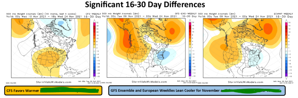
Cold returning after the mild interlude next week really would not surprise me. See if we can book a BN average for November. ECMWF monthlies came out today. First look, I grunted winter canceled after December. Chart is seasonable Dec. January and February composites are mild. However splitting into clusters, it's actually fairly close to 50/50 each month. There's a warm cluster; and both months, there's a pretty good cold cluster. In other words it's TBD. If November can end cold going into December, it could hold for a few more weeks until the first January thaw. Though not every year, a cold November is a bullish correlation for winter. If we come back Monday to a mild forecast and November crap-out, I'll sign off until March, lol! -
Fall 2021 Thread (September, October, November)
nrgjeff replied to Carvers Gap's topic in Tennessee Valley
Good morning @Mr. Kevin I will never dispute a warmer than normal forecast. Trend. But I try to offer hope. Pacific teleconnection roundup is robust! Do not share outside our region though. Valid after Day 15, but not really a forecast.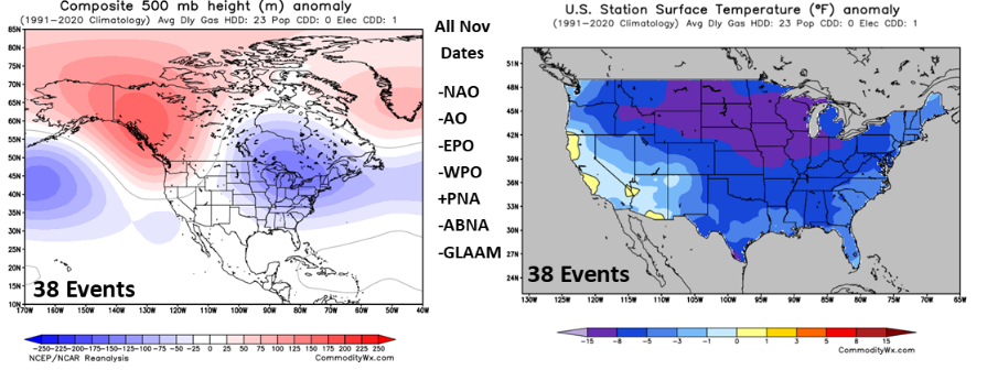
-
Fall 2021 Thread (September, October, November)
nrgjeff replied to Carvers Gap's topic in Tennessee Valley
We might be able to get that to work courtesy of the ABNA however the wavelength is a little squirrelly like you note. This is the European weekly composite of weeks 5-6. Historically those weeks offer zero forecast value but it's fun to look! It's not far from the coldest group of historical years. Again, just garbage. Should I move this to banter? There is the China tie-in so will put it here.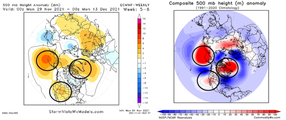
-
Come on down to Chattanooga. Always warmer here. Mountains surrounding the city are colorful up to 2,000 FT. By the weekend 2K+ will be past peak. Lower elevations look to tee up nicely again this year. Have not been to the Plateau which is usually cooler than even Lookout Mountain. Going to guess Lower Plateau great color 1,000 to 1,500 FT and maybe through the weekend. If we can just get decent weekend weather.
- 167 replies
-
- 2
-

-
- frost
- cold front
- (and 4 more)
-
Lovely day in Chattanooga with temps in the 60s. This is a blessing on days like today. I'll be whining about it when we are rain and 38, while y'all are snow.
- 167 replies
-
- 4
-

-
- frost
- cold front
- (and 4 more)
-
Fall 2021 Thread (September, October, November)
nrgjeff replied to Carvers Gap's topic in Tennessee Valley
Here's the Ensembles for Day 15. Warmer risks would be -GLAMM otherwise cold could happen. Welcome to the Cynical South @Blue Moon but I thought you're from here. As you know if it could snow in the South, still forecast rain. In Oswego NY, it's just the opposite. If it could snow in Upstate NY it will.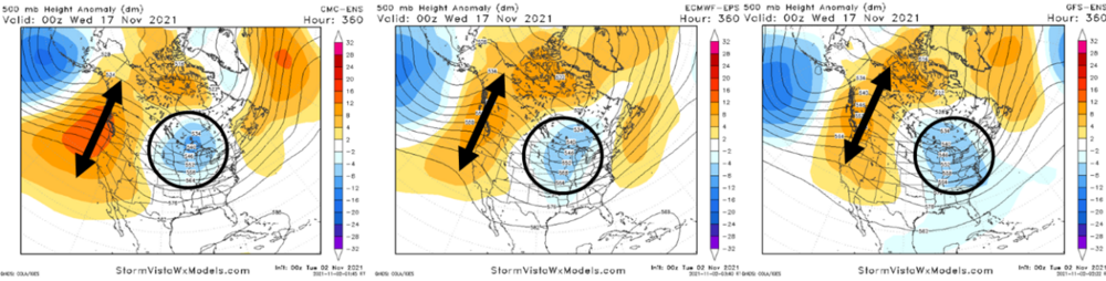
-
Fall 2021 Thread (September, October, November)
nrgjeff replied to Carvers Gap's topic in Tennessee Valley
European weeklies shift cooler second half of November. Normal instead of warmer, more in line with CFS. MJO would support. Also if ridging gets stuck in the Yukon, vs AK or West Coast. In the South we just hang onto Day 15. I've no thoughts on Friday. Actually I do but in kindergarten they said if you don't have anything nice to say... -
Fall 2021 Thread (September, October, November)
nrgjeff replied to Carvers Gap's topic in Tennessee Valley
Coolish pattern persists first 12-15 days of November. It's a start. But we gotta get rid of this overcast no precip. -
Indeed it came in under forecast. However the usual places cashed in. Lower 48 hype was always BS. Apparently Iceland gets another shot this evening. Could be too early North America. It's Never for the Lower 48.
-
Updates just after 00Z with a 24 hour forecast into the time of interest. https://www.swpc.noaa.gov/communities/space-weather-enthusiasts I feel like NOAA is less hype than the .com URL. If NOAA jacks up that Aurora Forecast movie chart (lower left) it's game time. For you guys. I'm South and cloudy. Double whammy!
-
Fall 2021 Thread (September, October, November)
nrgjeff replied to Carvers Gap's topic in Tennessee Valley
Yukon ridge would be cold down here November through Feb. In addition another stronger than forecast trip through MJO phases 5-6 would be colder than the 16-20 day models. -
Fall 2021 Thread (September, October, November)
nrgjeff replied to Carvers Gap's topic in Tennessee Valley
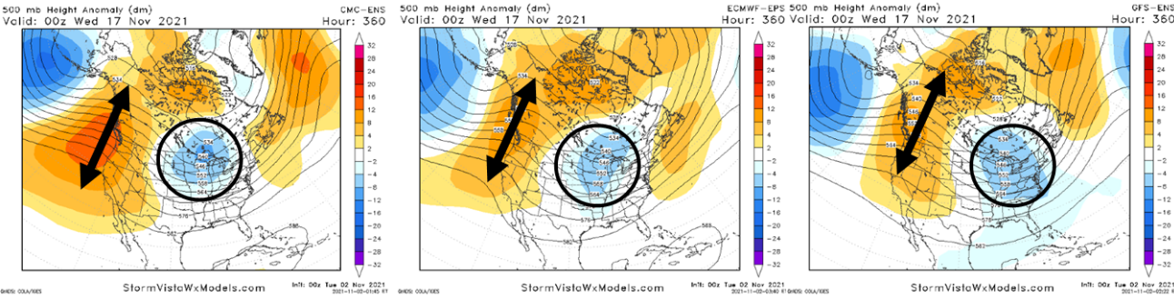
Interesting chatter now about a Yukon Ridge. They are actually quite rare in late October and early November. Alaska or West Coast are more common. Over history Yukon ridges are rare this exact time of year, but have been particularly stubborn once set up. Models break it down around Day 15 but then some hint at a rebuild 16-20 day. That 5-day composite is still warm, but details lurk. Do we tee up a cold November? Then do we leverage that correlation into the rest of winter? I'm not sold. La Nina is notoriously variable. On the bullish side though, perhaps the warm interlude is brief in a cold Novie. Image was posted a few days ago, so it's not the current 11-15 day. However the argument remains valid. Plus that falling -QBO. Please do not share the image outside our Region. -
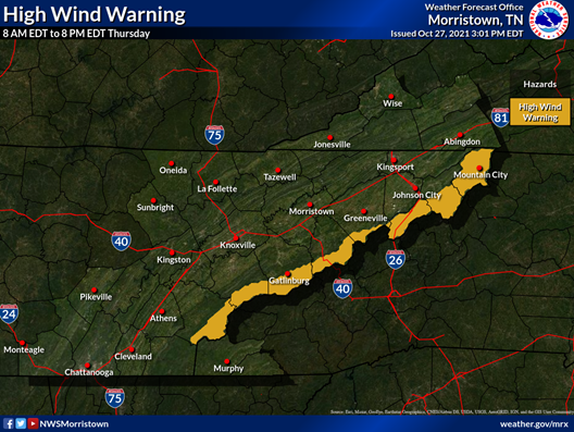
Thank you! We are Plateau bound Saturday. Have to figure the Smokies were stripped in the High Wind Warning. @John1122 what's the best elevation? I'm wondering somewhere close or haul up toward Frozen Head. Closer is ideal since we know the less crowded spots of the Plateau. Everyone, happy foliage. Remember cloudy can still yield excellent photography. Though I still prefer sunny, we take what we get.
- 167 replies
-
- 1
-
-
- frost
- cold front
- (and 4 more)
-
We need a rave glowstick emoji / reaction for events like above. Meanwhile Chattanooga feels like Wichita this morning. Wind is blowing from the south and it's stiff. Started right at 8am. MRX with the precision advisories, haha!
- 167 replies
-
- 2
-
-
- frost
- cold front
- (and 4 more)
-
I was waiting for peak up there. Looks like I waited too long. It's peak but ruined. When did fall foliage become as frustrating as storm chasing? Meanwhile the Gulf Coast got hammered Wednesday. Surprising contrast on not so grungy tornadoes.
-
Welp. Fall foliage goes down the shitter in the southern Apps. Hopefully the Cumberland Plateau does much better holding foliage.
-
Fall 2021 Thread (September, October, November)
nrgjeff replied to Carvers Gap's topic in Tennessee Valley
Anyway John is right about November correlation to winter. October is worthless. November tends to correlate with the balance of winter, Dec-Feb. Not every year, but over the years November and bal-winter have a decent correlation coefficient. March always does what March wants to do, haha! Deterministic models, Ensembles, and Weeklies all seem to want to start November cold. That's only the first week or two, and not the whole month. However it's baby steps if one is eyeing the November and balance of winter correlation. GFS wants to get mild by mid-Nov. GOA low yuck. Euro is still cool-ish. Canadian wants to reload cold, with another ridge poking into western Canada. MJO could favor the Euro in between solution. Champions Classic is in November. This year with have two versions. College basketball, and the three weather models. Check back in two weeks! -
Fall 2021 Thread (September, October, November)
nrgjeff replied to Carvers Gap's topic in Tennessee Valley
Sell natural gas! Not investment advice. I'm just tired of the ECWMF weeklies choking. And don't sell natty in the face of this upward momentum. At least not today. However the weeklies might have MJO support. Both the EC and GFS weeklies have the cooler look. Legacy CFS goes warm. Let's see which works out. Check back in two weeks. Please do not share the image outside of our Region.