

cleetussnow
-
Posts
3,129 -
Joined
-
Last visited
Content Type
Profiles
Blogs
Forums
American Weather
Media Demo
Store
Gallery
Everything posted by cleetussnow
-
-
We track.
-
I can see chucking the 6th. Not our storm. The 11th or thereabouts - no sense chucking this early. Its not even within 240. There may be another wave behind it as well. We’ll have to see but this time frame should still hold interest.
-
Suppression depression. Too much of a good thing
-
No.
-
With weather
-
I noticed there isn’t a universal push by forum members to spring him from 5 post jail. PS. We may have a miller B brewing on gfs. edit: no. Weird solution
-
You haven’t got a clue. You are out of your depth.
-
Yes indeed. That is not a common sight on models or out the window. Wow
-
If pythons are exposed they will. Snakes burrow down there, so they may make it if they can get underground and it doesn’t freeze hard enough. They need to be culled and nothing like a hard freeze to do the job. A few hard freezes throughout the winter would work wonders.
-
Florida could use a good freeze to kill off the invasive snakes and give people a chance to knock down the iguana invasive population. Couple days of that would take a bite.
-
Excellent idea.
-
I raced motorcycles, same vibe more money lol
-
TECS DECS CECS
-
BECS being the weenie fav. Anything over 40 = BECS.
-
Agree. I've had 12 days straight of complete snow coverage, better than a lot of New England right now. Coupled with the cold, this is quite good. I'll take this December anytime.
-
Legit there is a good pattern modeled. Lets do this
-
Agree. Everyone needs to accept the meaning of 'pattern' in terms of sensible weather. Pattern is mass field - not storms, and only moderately meaningful for sensible weather. With the exception of the global gyre as Tip has referenced, storminess is theoretical only. But this board likes sensible measurable weather. We need to get a storm in the operationals with a couple days of consistency and then we can talk sensible. I don't care if it's day 3 or 10 - give me 3 operationals with 2 or 3 days of consistent runs on a threat, then we can fire up a thread and have at it. There cannot be A storm threat based on h5 looks on the 10 - 15 day ensembles and I feel that's how some people perceive those depictions. We can be optimists tho. Feel free. I also don't like the buzzkillers taking aim and positive vibes.
-
this could come north. I'd watch
-
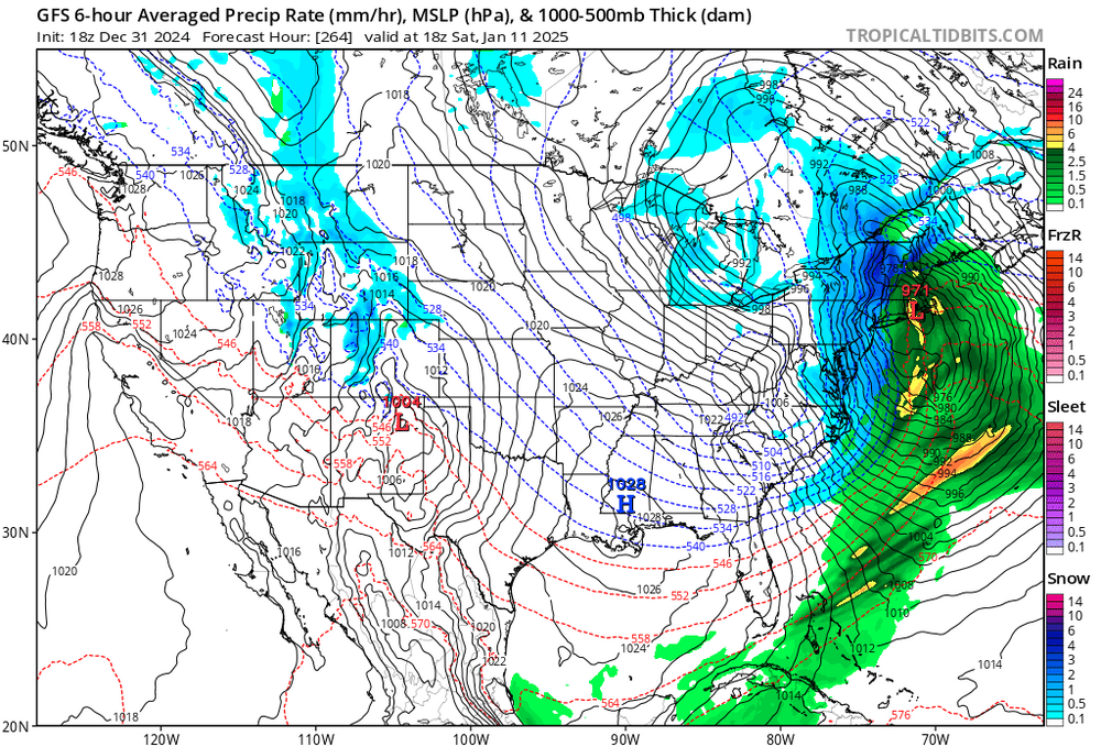
If you see a gfs storm 240 hrs with a foot over dc, then its congrats NE every time. Locking in suppression at this range is never advised and they know that.
-
We are more of a Christmas vacation family. Was on all morning down here.
-
I probably jacked on these last 2 storms. I still have 2 on the ground right now. Probably had 3.something all told. Still snow on the bushes. Idyllic.
-
I soak the underneath of my truck with fluid film. I’ve seen some nice low miles truck whipped on account of the salt. Up north in some areas they use a salt/beat juice spray which is supposedly better.
-
We got yer back
-
This is great Don. Laid it out perfectly. If we can get some base hits in that pattern I’d take it all day long esp. if we can have snow OTG for a couple weeks. That’d be a big change vs recent winters.


