Kmlwx
-
Posts
13,549 -
Joined
-
Last visited
Content Type
Profiles
Blogs
Forums
American Weather
Media Demo
Store
Gallery
Everything posted by Kmlwx
-
Snapped this picture of an unusual visitor to BWI earlier. Sierra Pacific Airlines has only two planes in their fleet. They last made a stop in Baltimore in late February. Seems they charter for military sometimes/often. Have been experimenting with an app called JetTip the past day or two. Has been cool to get an advanced heads up of "interesting" planes going into selected airports. Not a great picture - had to reduce it down a bit to fit on here.

-
Was just remarking about this to the family a few minutes ago. Beautiful out (other than the bugs). 70 degrees and falling at 8:30pm-ish after the middle of June with a dewpoint in the mid 50s is crazy.
-

2023 Mid-Atlantic Severe Wx Thread (General Discussion)
Kmlwx replied to Kmlwx's topic in Mid Atlantic
Indeed - SPC placed that slight risk in the right spots! -
2023 Mid-Atlantic Severe Wx Thread (General Discussion)
Kmlwx replied to Kmlwx's topic in Mid Atlantic
There was some spin I guess at high levels. Nothing near surface. Just an appendage really I think. And that Loudoun storm is crap now regardless.- 2,785 replies
-
- 1
-

-
- severe
- thunderstorms
- (and 3 more)
-
2023 Mid-Atlantic Severe Wx Thread (General Discussion)
Kmlwx replied to Kmlwx's topic in Mid Atlantic
Meh -
2023 Mid-Atlantic Severe Wx Thread (General Discussion)
Kmlwx replied to Kmlwx's topic in Mid Atlantic
Expansion of the existing watch to the south. They are sneaky like that sometimes when the area is not big enough for a new watch.- 2,785 replies
-
- 1
-
-
- severe
- thunderstorms
- (and 3 more)
-
2023 Mid-Atlantic Severe Wx Thread (General Discussion)
Kmlwx replied to Kmlwx's topic in Mid Atlantic
It looks like LWX/SPC coordinated a local expansion of the watch to the south. I'm still left out seemingly. Oh well.- 2,785 replies
-
- 1
-

-
- severe
- thunderstorms
- (and 3 more)
-
2023 Mid-Atlantic Severe Wx Thread (General Discussion)
Kmlwx replied to Kmlwx's topic in Mid Atlantic
I see you sneakily added the question mark -
2023 Mid-Atlantic Severe Wx Thread (General Discussion)
Kmlwx replied to Kmlwx's topic in Mid Atlantic
After the SPC issuing a MCD for 20% chance -
2023 Mid-Atlantic Severe Wx Thread (General Discussion)
Kmlwx replied to Kmlwx's topic in Mid Atlantic
MCD coming out - https://t.co/duty3P6Iy9 - Link may not be working yet. -
2023 Mid-Atlantic Severe Wx Thread (General Discussion)
Kmlwx replied to Kmlwx's topic in Mid Atlantic
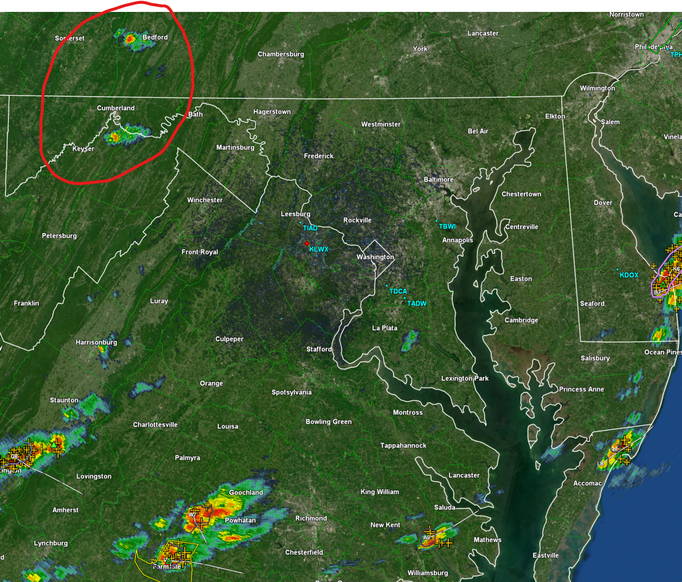
That is a beefy cell - no competition and I don't see any outflow yet. Pretty atypical for our area. Of course now that I said it the next frame will gust out Lightning production has been a good indicator of path and intensity tendency with this. The lightning has tended to be SE or even S of the radar returns...some of that is likely the radar data lagging behind the radar update - but I'd say areas just south of the Potomac look great right now if it maintains.- 2,785 replies
-
- 1
-
-
- severe
- thunderstorms
- (and 3 more)
-
2023 Mid-Atlantic Severe Wx Thread (General Discussion)
Kmlwx replied to Kmlwx's topic in Mid Atlantic
Cell continues to look healthy. Track is not so great for me. Seems it will straddle or go just south of the Potomac. Looks good for places like Herndon - and further down the line DC proper. -
2023 Mid-Atlantic Severe Wx Thread (General Discussion)
Kmlwx replied to Kmlwx's topic in Mid Atlantic
Wonder if outflow from the Winchester area storm can start to pop some other activity. So far, situation matches up pretty well with HRRR runs. -
2023 Mid-Atlantic Severe Wx Thread (General Discussion)
Kmlwx replied to Kmlwx's topic in Mid Atlantic
The cell N of Winchester has a hail marker on it now. Bears watching. Uptick in lightning production in that one as well.- 2,785 replies
-
- 3
-
-
- severe
- thunderstorms
- (and 3 more)
-
2023 Mid-Atlantic Severe Wx Thread (General Discussion)
Kmlwx replied to Kmlwx's topic in Mid Atlantic
The stuff down in VA is legit. -
2023 Mid-Atlantic Severe Wx Thread (General Discussion)
Kmlwx replied to Kmlwx's topic in Mid Atlantic
Looking into the long range - the CFS still seems to want to setup the potential for some NW flow stuff in the heart of July (ridge centered over the middle of the country). Would be interesting if our entire severe season was kind of shifted a month or so later. -
2023 Mid-Atlantic Severe Wx Thread (General Discussion)
Kmlwx replied to Kmlwx's topic in Mid Atlantic
I'll still radar-watch all afternoon - keeping an eye on the red circled stuff.
- 2,785 replies
-
- 1
-
-
- severe
- thunderstorms
- (and 3 more)
-
2023 Mid-Atlantic Severe Wx Thread (General Discussion)
Kmlwx replied to Kmlwx's topic in Mid Atlantic
And that reflects that watch lol -
2023 Mid-Atlantic Severe Wx Thread (General Discussion)
Kmlwx replied to Kmlwx's topic in Mid Atlantic
16z HRRR back to sucking locally. Shafts just about everyone unless you're south of DC - and really the best stuff goes to the Northern Neck and extreme Southern Maryland. -
FWIW - interesting product.
-
At the high of the day now that the sun has come up and started to warm things. 71.2 after a low of 56.3 this morning. Dewpoint has crept up a few degrees as well to 62. Now we wait to see if the "recovery" will be enough for good storms later.
-
2023 Mid-Atlantic Severe Wx Thread (General Discussion)
Kmlwx replied to Kmlwx's topic in Mid Atlantic
Well - if we end up with nada it certainly won't be due to lack of sunshine. Plenty of sun out there now. I'd be decently intrigued if I lived in PG, Anne Arundel, Calvert, Charles, St Mary's counties or the Eastern Shore. Perhaps even NoVA. More of a question mark for the Montgomery, Howard, Carrol Co folks. -
2023 Mid-Atlantic Severe Wx Thread (General Discussion)
Kmlwx replied to Kmlwx's topic in Mid Atlantic
15z HRRR for this afternoon.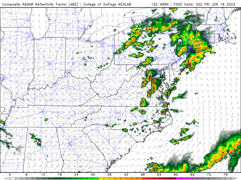
- 2,785 replies
-
- 2
-
-
- severe
- thunderstorms
- (and 3 more)
-
Temp of 63.7 here and a dewpoint sub-60. Doesn't scream severe risk - should get some juicier air perhaps in the wake of the morning crap-'vection' if you can call it that locally.
-
2023 Mid-Atlantic Severe Wx Thread (General Discussion)
Kmlwx replied to Kmlwx's topic in Mid Atlantic
14z HRRR continues to look decent...though it kind of favors VA and then east of DC (shocker). Encouraging that it seems to be picking up on the fact that our environment might recover a bit given the precip in the area now is really fizzling. Just gotta get this stuff outta here!