-
Posts
13,431 -
Joined
-
Last visited
Content Type
Profiles
Blogs
Forums
American Weather
Media Demo
Store
Gallery
Everything posted by Kmlwx
-
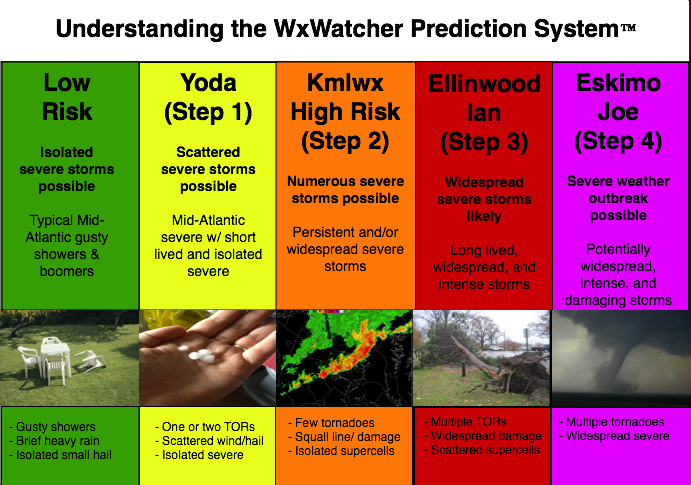
Given that there is a tiny chance at something next week, we'll go ahead and open up the 2023 iteration of the thread. I doubt it will amount to much of anything (perhaps a better chance in the Carolinas and far SEVA) but we'll see. General mid to long range discussion can go in here, as can discussion about past events etc. In past years this has also served as a bit of an "on the fly" obs thread for events that are too small to warrant a separate thread. Pretty casual rules in this annual thread. Looking forward to our usual folks And as always - attached is the @WxWatcher007 tier system for our severe threats here in the Mid-Atlantic subforum.
- 2,785 replies
-
- 9
-

-

-
- severe
- thunderstorms
-
(and 3 more)
Tagged with:
-

2022 Mid-Atlantic Severe Wx Thread (General Discussion Etc)
Kmlwx replied to Kmlwx's topic in Mid Atlantic
I'd venture a guess (not a very gutsy one) that any severe threat will be focused in eastern NC and perhaps SEVA. Maybeeee Southern Maryland or the lower eastern shore can get something as well. Just my two cents for now. -

2022 Mid-Atlantic Severe Wx Thread (General Discussion Etc)
Kmlwx replied to Kmlwx's topic in Mid Atlantic
The weather has been so boring lately other than the wind/rain recently. This is not our severe season...so we will probably fail - but I'm intrigued. It's too far out to do a deep dive yet. -

2022 Mid-Atlantic Severe Wx Thread (General Discussion Etc)
Kmlwx replied to Kmlwx's topic in Mid Atlantic
I must not have brought my A-game. I blame my real world job -

2022 Mid-Atlantic Severe Wx Thread (General Discussion Etc)
Kmlwx replied to Kmlwx's topic in Mid Atlantic
Climo argues for a pencil thin line of gusty showers at best. We'll assess the need for the 2023 thread once we get closer -

2022 Mid-Atlantic Severe Wx Thread (General Discussion Etc)
Kmlwx replied to Kmlwx's topic in Mid Atlantic
My job - take it super seriously lol - we usually can get away with February. Would be something if we needed it sooner. -
IMO it's no worse than normal. It's mostly the usual suspects trolling, the usual suspects having meltdowns, and the usual folks providing good (even if not good for snow lovers) data. We go through this every year - by the time early April rolls around we'll be back into our cordial crew around here that doesn't spend 23 hours a day picking fights and fitting every stereotype about an online forum
-
Sounds like there are a couple folks in here that need a nap.
-
5 on the dot for the low here. Up to 7.3 now.
-
Double whammy - that sucks! Hope you feel better as well! Heard some people are getting a bitter/metallic taste as a side effect of the Paxlovid. Guess it beats the alternative, though...
-
With everyone seeing family and such the next two weeks - BE SAFE. I admittedly have not gotten the updated booster for COVID, but I have COVID now and am battling a 103+ fever. Luckily was able to get a script for Paxlovid without too much effort. Wash your hands, people!
-
Officially into the teens in Colesville (19.8). Barely any ice on the roads - it all dried up before it could freeze. A few icy patches in parking lots around here.
-
Hovering around 38 degrees after dropping a degree lower than that.
-
IIRC the GFS is based on an FV3 core. So it sort of makes some sense that they'd agree. Believe the FV3 is slated to replace the various hi-res/regional models.
-
Gotta ensure they keep their budget up somehow.
-

2022 Mid-Atlantic Severe Wx Thread (General Discussion Etc)
Kmlwx replied to Kmlwx's topic in Mid Atlantic
0% hail but 100% wind and 100% tor lol -
Imagine an H5 map like the ICON during the severe season.
-

2022 Mid-Atlantic Severe Wx Thread (General Discussion Etc)
Kmlwx replied to Kmlwx's topic in Mid Atlantic
Let's reactivate this thread for the late week system. Maybe we can reverse psychology it back to a snow event. Imagine an H5 setup like this in the warm season lol. -
Tornado Watches.
-
I want warnings to be hoisted. Why hasn't LWX hoisted warnings yet? Seems like there should be warnings with this package. It's less than 24 hours away...what's taking them so long? CTP already hoisted them!
-
Woke up in Colesville to a below-freezing temp but the rain was just coming down too hard to accrete. Wet roads only. Better chance of hydroplaning on my way in to work versus sliding on ice.
-
34/27 and that dewpoint is on the rise.
-
I understand where you are coming from. But for ice...even .01" of accretion in the wrong spot could cause a crash - and if that involves a bus everyone will complain they didn't play it safe. School systems play it SUPER safe with icing.
-
36/23 in Colesville
-
Distance will matter as usual. The father NW, the more icy. We will be right on the line in the Colesville/Wheaton/Cloverly areas. Probably minor icing for us


