

Kmlwx
-
Posts
13,549 -
Joined
-
Last visited
Content Type
Profiles
Blogs
Forums
American Weather
Media Demo
Store
Gallery
Everything posted by Kmlwx
-
May the odds be NEVER in your favor ~President Snow
-
You're in charge of diverting all the poop away from the community, then. We'll keep you around...for now.
-
Couldn't you help us bring fresh water to the group?
-
Imagine a reality show where they take all of us and dump us in some island destination survivor-style.
-
I may ping you privately - girlfriend is looking to do a partial bathroom remodel - she wants to do it DIY but it would involve knocking out a weird wall. Plus...we both have full time jobs.
-
I'll start...I just picked up a Steam Deck and it's been great being able to work through my backlog of games that I bought on sales and never once played. Mindless time wasting!
-
I realize that some people here are retired, work for themselves, or have various situations that vary... But am I the only one that is too busy with a 9-5 job to allow a lack of snow to impact my treatment of others on a weather forum THIS MUCH? There's also a ton of folks in here that seem to post a lot just to inflate their post counts or feel the need to type out a post just for the sake of doing it. I guess for some it makes them feel like they are contributing - and many are...but this place has such weird spikes of bitterness and bickering... There can't be THAT many of you on here that don't have lives outside of a weather forum... Does anyone have fun PTO or vacations scheduled coming up? Anyone going to a warm/tropical destination? What books are you guys reading? Current favorite video game? Cool DIY projects? Maybe it's that this time of year has a unique blend of football teams getting eliminated from contention, lack of snowfall, seasonal affective disorder, and these past few years COVID-fatigue...but come on... Sometimes feels like we'd be better off in winter having EVERYONE be post-limited except for a select few (I'd volunteer to be post limited myself...because I have nothing to add here that would be useful). Let's all just remember that we are actual people behind computer screens and keyboards...doesn't take much effort to 1) Be decent to each other and 2) Have a little fun. If you can't do either of those, you're better off lurking only and taking out your rage at a smash room or something. Some of you all legitimately seem like being on AmericanWx is harming you to the core. That's not healthy. It is COMPLETELY okay to step away and not post for a few days/weeks. We will be here when you get back. The world will continue to turn. You will NOT miss anything critical to your existence by living your life outside of the internet for 24 hours (or longer!). Another piece of advice...READ YOUR OWN POSTS BEFORE YOU POST THEM! If you are noticing that every single post of yours is sounding eerily similar to the last...stop posting for now.
-

2023 Mid-Atlantic Severe Wx Thread (General Discussion)
Kmlwx replied to Kmlwx's topic in Mid Atlantic
I saw this thread had activity and I got excited....now I'm sad. It's not for us!- 2,785 replies
-
- 1
-

-
- severe
- thunderstorms
- (and 3 more)
-
Ridiculously heavy downpour briefly in Colesville, MD. Over as fast as it started.
-
2023 Mid-Atlantic Severe Wx Thread (General Discussion)
Kmlwx replied to Kmlwx's topic in Mid Atlantic
12z NAM nest reflectivity actually looked semi decent between 4 and 5z tomorrow night. Worst time of day for something to come through...but sure beats the boring weather around here.- 2,785 replies
-
- 1
-

-
- severe
- thunderstorms
- (and 3 more)
-
January Mid/Long Range Disco 3: The great recovery or shut the blinds?
Kmlwx replied to psuhoffman's topic in Mid Atlantic
Ninja'd -
January Mid/Long Range Disco 3: The great recovery or shut the blinds?
Kmlwx replied to psuhoffman's topic in Mid Atlantic
Whoever went out and bought a snow blower or electric shovel in the past few years really needs to be kicked out of the Mid-Atlantic. -
I totally threw the 95% out as an arbitrary number and you went full math nerd on me But yes - 4.6 snow days sounds like a hell of a deal right now.
-
Ultimately it IS disappointing but many (not all of course) of the folks on here pick up other hobbies to fill the gaps in tracking. It can definitely be a downer...but without other activities we'd all be a dumpster fire mentally (some are!). I know others have recommended this to you - but you are going to find yourself being very mentally unwell if you tie all of your happiness to snow in the DC area. It's just a losing proposition 95% of the time.
-
2023 Mid-Atlantic Severe Wx Thread (General Discussion)
Kmlwx replied to Kmlwx's topic in Mid Atlantic
No snow, no severe, borrrrrring. Just how weather is around these parts most times! -
2023 Mid-Atlantic Severe Wx Thread (General Discussion)
Kmlwx replied to Kmlwx's topic in Mid Atlantic
The models seem to continue to suggest that any isolated severe threat will be SE of most of us. -
2023 Mid-Atlantic Severe Wx Thread (General Discussion)
Kmlwx replied to Kmlwx's topic in Mid Atlantic
It's immortalized. Unless somebody changes their personality completely, it will always work.- 2,785 replies
-
- 1
-

-
- severe
- thunderstorms
- (and 3 more)
-
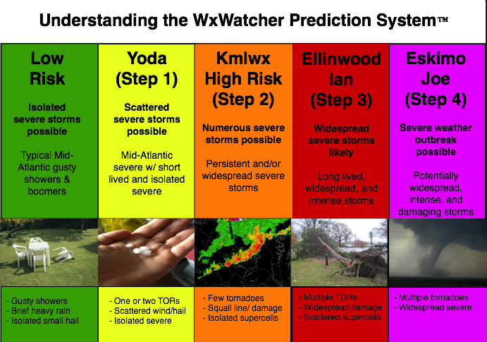
Given that there is a tiny chance at something next week, we'll go ahead and open up the 2023 iteration of the thread. I doubt it will amount to much of anything (perhaps a better chance in the Carolinas and far SEVA) but we'll see. General mid to long range discussion can go in here, as can discussion about past events etc. In past years this has also served as a bit of an "on the fly" obs thread for events that are too small to warrant a separate thread. Pretty casual rules in this annual thread. Looking forward to our usual folks And as always - attached is the @WxWatcher007 tier system for our severe threats here in the Mid-Atlantic subforum.
- 2,785 replies
-
- 9
-
-
-
- severe
- thunderstorms
- (and 3 more)
-
2022 Mid-Atlantic Severe Wx Thread (General Discussion Etc)
Kmlwx replied to Kmlwx's topic in Mid Atlantic
I'd venture a guess (not a very gutsy one) that any severe threat will be focused in eastern NC and perhaps SEVA. Maybeeee Southern Maryland or the lower eastern shore can get something as well. Just my two cents for now. -
2022 Mid-Atlantic Severe Wx Thread (General Discussion Etc)
Kmlwx replied to Kmlwx's topic in Mid Atlantic
The weather has been so boring lately other than the wind/rain recently. This is not our severe season...so we will probably fail - but I'm intrigued. It's too far out to do a deep dive yet. -
2022 Mid-Atlantic Severe Wx Thread (General Discussion Etc)
Kmlwx replied to Kmlwx's topic in Mid Atlantic
I must not have brought my A-game. I blame my real world job -
2022 Mid-Atlantic Severe Wx Thread (General Discussion Etc)
Kmlwx replied to Kmlwx's topic in Mid Atlantic
Climo argues for a pencil thin line of gusty showers at best. We'll assess the need for the 2023 thread once we get closer -
2022 Mid-Atlantic Severe Wx Thread (General Discussion Etc)
Kmlwx replied to Kmlwx's topic in Mid Atlantic
My job - take it super seriously lol - we usually can get away with February. Would be something if we needed it sooner. -
IMO it's no worse than normal. It's mostly the usual suspects trolling, the usual suspects having meltdowns, and the usual folks providing good (even if not good for snow lovers) data. We go through this every year - by the time early April rolls around we'll be back into our cordial crew around here that doesn't spend 23 hours a day picking fights and fitting every stereotype about an online forum
-
Sounds like there are a couple folks in here that need a nap.
