

Kmlwx
-
Posts
13,549 -
Joined
-
Last visited
Content Type
Profiles
Blogs
Forums
American Weather
Media Demo
Store
Gallery
Everything posted by Kmlwx
-

2023 Mid-Atlantic Severe Wx Thread (General Discussion)
Kmlwx replied to Kmlwx's topic in Mid Atlantic
FWIW (probably not much) - the 13z HRRR blew up really intense cells in the area (still favoring east but it is a marked improvement) around 19-20z. -
2023 Mid-Atlantic Severe Wx Thread (General Discussion)
Kmlwx replied to Kmlwx's topic in Mid Atlantic
Thinking that for DC proper and areas W of I-95 we really need to get this now junky stuff to just GTFO so we can "recover" behind the line for some isolated cells later. If this stuff takes it's time and we just stay cloudy we are probably cooked for anything decent. -
2023 Mid-Atlantic Severe Wx Thread (General Discussion)
Kmlwx replied to Kmlwx's topic in Mid Atlantic
You know it's bad when the most exciting weather event in recent times has been smoke.- 2,785 replies
-
- 1
-

-
- severe
- thunderstorms
- (and 3 more)
-
2023 Mid-Atlantic Severe Wx Thread (General Discussion)
Kmlwx replied to Kmlwx's topic in Mid Atlantic
Wow...the 10z HRRR sucked.- 2,785 replies
-
- 1
-

-
- severe
- thunderstorms
- (and 3 more)
-
2023 Mid-Atlantic Severe Wx Thread (General Discussion)
Kmlwx replied to Kmlwx's topic in Mid Atlantic
Quite a bit of lightning with the activity to the west! So far radar actually looks decent despite the early timeframe. Some of the guidance weakened it and then kind of skipped it over us - but for now I remain semi interested given the current pic -
2023 Mid-Atlantic Severe Wx Thread (General Discussion)
Kmlwx replied to Kmlwx's topic in Mid Atlantic
All good! Though - you might have spoken it into existence - KLWX has been having issues lately it seems. Lots of downtime recently. -
2023 Mid-Atlantic Severe Wx Thread (General Discussion)
Kmlwx replied to Kmlwx's topic in Mid Atlantic
A lot of the guidance is pretty emphatic on the idea of weakening the stuff to the west as it approaches and the intensifying it once it's east of many of us - @CAPE being the exception and anyone else mainly east of I-95 but really even east of the bay. A mix of the guidance still shows some cells popping up during the afternoon behind the initial activity...but we all know how this story goes. Despite what LWX says about the atmosphere recharging...I have my doubts. Current SPC SLGT area looks solid to me. Hoping for a good storm IMBY - but I have my doubts. -
2023 Mid-Atlantic Severe Wx Thread (General Discussion)
Kmlwx replied to Kmlwx's topic in Mid Atlantic
@Eskimo Joe - Was it this? Was it moved up - because they originally showed June 20-30ish- 2,785 replies
-
- 1
-

-
- severe
- thunderstorms
- (and 3 more)
-
2023 Mid-Atlantic Severe Wx Thread (General Discussion)
Kmlwx replied to Kmlwx's topic in Mid Atlantic
If there was any radar in the country to gamble with - it would be KLWX. We have TIAD, TDCA and TBWI in the area that can provide coverage for the immediate metro and many surrounding areas. Buy yeahhh - that's not ideal.- 2,785 replies
-
- 1
-
-
- severe
- thunderstorms
- (and 3 more)
-
2023 Mid-Atlantic Severe Wx Thread (General Discussion)
Kmlwx replied to Kmlwx's topic in Mid Atlantic
Still an early-ish arrival on the 18z NAM nest but I like how it looks better than the last run. It's a little more "clean" and actually gets MBY good storms.- 2,785 replies
-
- 2
-
-
- severe
- thunderstorms
- (and 3 more)
-
2023 Mid-Atlantic Severe Wx Thread (General Discussion)
Kmlwx replied to Kmlwx's topic in Mid Atlantic
The 12z NAM nest shows activity on the earlier side that intensifies east of 95 - some isolated stuff pops up later in the day as well - but seems like this could be a case where early stuff stabilizes much of the area. We'll see how it unfolds tomorrow. Best threat probably E of 95... -
2023 Mid-Atlantic Severe Wx Thread (General Discussion)
Kmlwx replied to Kmlwx's topic in Mid Atlantic
OT - But wouldn't it be comedic if the ultimate result locally of climate change turns out to be less exciting weather during our severe season(s) and less snow during the winter? Watch us just turn into a mild-mannered weather area entirely. Guess we have to rely on once per lifetime 5.9 earthquake events from now on for our excitement.- 2,785 replies
-
- 6
-
-

-
-

-
- severe
- thunderstorms
- (and 3 more)
-
2023 Mid-Atlantic Severe Wx Thread (General Discussion)
Kmlwx replied to Kmlwx's topic in Mid Atlantic
Marginal for Friday. -
2023 Mid-Atlantic Severe Wx Thread (General Discussion)
Kmlwx replied to Kmlwx's topic in Mid Atlantic
Should we start putting all our chips into an August-Oct tropical threat for our weather weenie excitement?- 2,785 replies
-
- 1
-
-
- severe
- thunderstorms
- (and 3 more)
-
2023 Mid-Atlantic Severe Wx Thread (General Discussion)
Kmlwx replied to Kmlwx's topic in Mid Atlantic
Purely going off the supercell composite parameter - long range GFS isn't really excited about anything through the end of the run either. Unless there's something anomalous we may skip right into summer pulse-style storm season and skip over the "meaty" severe season locally. At least last year there were some decent storm days even if sub-severe. Pairing it with this past winter's lack of snow...this has been a really tame stretch for weather weenies in this area. I'm a big fan of the "rubber band" effect coming to get us at some point...but who knows... -
2023 Mid-Atlantic Severe Wx Thread (General Discussion)
Kmlwx replied to Kmlwx's topic in Mid Atlantic
This is one of the quietest May--> June periods in my recent memory from a local severe wx standpoint. The NAM nest shows a chance for some storms tomorrow. -
2023 Mid-Atlantic Severe Wx Thread (General Discussion)
Kmlwx replied to Kmlwx's topic in Mid Atlantic
I always say it - but often times things seem to speed up as we get closer. Not always - and may be solely anecdotal...but if lines of storms are expected 4-8pm - can usually bet on something coming through between 2 and 5 -
69 on the dot in Colesville! For June 9th that is amazing.
-
No stench here and visibility is much better than yesterday morning. Nice morning out there for the most part! Low of 49 here.
-
I was able to see sunspots using my S23 Ultra's camera. I can DEFINITELY "feel" the poor AQI now. Noticeable cough this morning. The odor isn't really like that nice bonfire odor either - it almost smells like fabric burning.
-
2023 Mid-Atlantic Severe Wx Thread (General Discussion)
Kmlwx replied to Kmlwx's topic in Mid Atlantic
This truly is quite the boring stretch locally in terms of severe. It will break at some point...- 2,785 replies
-
- 1
-
-
- severe
- thunderstorms
- (and 3 more)
-
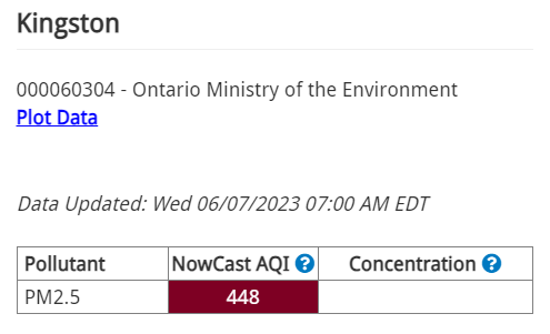
Up in Canada in the big plume coming down now -
-
Bad enough at the surface here that it looks like fog. Yesterday's HRRR runs seemed to indicate a BIG plume coming down later today into tonight potentially making it even worse.
-
HRRR seems to suggest smoke will be even worse tomorrow afternoon/evening as another batch of smoke gets pushed down into our area.
-
2023 Mid-Atlantic Severe Wx Thread (General Discussion)
Kmlwx replied to Kmlwx's topic in Mid Atlantic
Quoting you over here - certainly a nice look! 9 days away, though!