

Kmlwx
-
Posts
13,549 -
Joined
-
Last visited
Content Type
Profiles
Blogs
Forums
American Weather
Media Demo
Store
Gallery
Everything posted by Kmlwx
-

2023 Mid-Atlantic Severe Wx Thread (General Discussion)
Kmlwx replied to Kmlwx's topic in Mid Atlantic
Actually looks decent on radar for the DC Metro area. Some lead activity has developed as well. Nasty looking bow structure coming up through VA.- 2,785 replies
-
- 1
-

-
- severe
- thunderstorms
- (and 3 more)
-
2023 Mid-Atlantic Severe Wx Thread (General Discussion)
Kmlwx replied to Kmlwx's topic in Mid Atlantic
- 2,785 replies
-
- 7
-
-

-
- severe
- thunderstorms
- (and 3 more)
-
2023 Mid-Atlantic Severe Wx Thread (General Discussion)
Kmlwx replied to Kmlwx's topic in Mid Atlantic
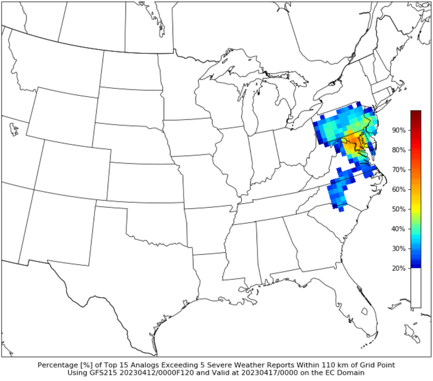
Instability/moisture concerns ignored - CIPS is really highlighting the 120hr period -
2023 Mid-Atlantic Severe Wx Thread (General Discussion)
Kmlwx replied to Kmlwx's topic in Mid Atlantic
Too far out for now...but Sunday may have some potential - and does get a mention in the D4-8 outlook - but uncertainty is too high per their discussion (SPC). -
2023 Mid-Atlantic Severe Wx Thread (General Discussion)
Kmlwx replied to Kmlwx's topic in Mid Atlantic
Has gone about as expected - main threat was south and east of the metros but the DC metro area still got some rain/storms/gusts. Also goes to show you - can't rely solely on CIPS (not that anyone was) but it showed almost NO enthusiasm for today's threat...and yet - decent number of LSRs to the south and east.- 2,785 replies
-
- 1
-
-
- severe
- thunderstorms
- (and 3 more)
-
2023 Mid-Atlantic Severe Wx Thread (General Discussion)
Kmlwx replied to Kmlwx's topic in Mid Atlantic
Updrafts west of DC are having trouble sustaining. Meh. -
2023 Mid-Atlantic Severe Wx Thread (General Discussion)
Kmlwx replied to Kmlwx's topic in Mid Atlantic
Okay Nostradamus- 2,785 replies
-
- 3
-
-

-
- severe
- thunderstorms
- (and 3 more)
-
2023 Mid-Atlantic Severe Wx Thread (General Discussion)
Kmlwx replied to Kmlwx's topic in Mid Atlantic
Heck of a narrow one - and many of us are #fringed -
2023 Mid-Atlantic Severe Wx Thread (General Discussion)
Kmlwx replied to Kmlwx's topic in Mid Atlantic
Decent amount of guidance seems to favor exactly where SPC has the higher probs. Still, see a few models that get DC with good activity. We'll see. Definitely not the @Eskimo Joe outbreak. -
78 and beautiful out there IMBY right now. Only downside is I've seen 3 massive wasps around the exterior of the house already today. Going to need to re-up my pest control application...
-
2023 Mid-Atlantic Severe Wx Thread (General Discussion)
Kmlwx replied to Kmlwx's topic in Mid Atlantic
FV3 Hi-res at range shows stuff developing Thur PM but mainly for I-95 and east. -
2023 Mid-Atlantic Severe Wx Thread (General Discussion)
Kmlwx replied to Kmlwx's topic in Mid Atlantic
Perhaps there needs to be an additional criteria added. "If ____ is out of town for event, automatic upgrade to that tier"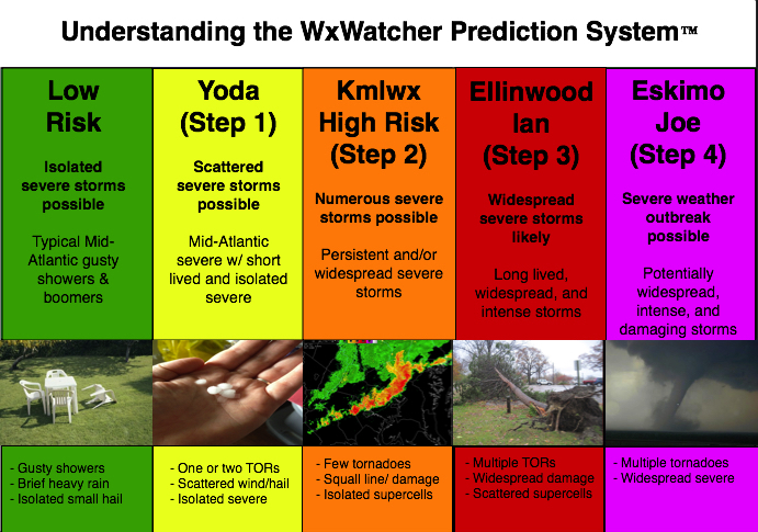
- 2,785 replies
-
- 8
-
-
- severe
- thunderstorms
- (and 3 more)
-
Third aircraft just flew over - same deal...not visible on ADS-B until roughly over IAD area and then TIS-B got it inbound to Andrews. This one was definitely a passenger style jet though - two engines - only got a look at the underbelly as it flew over from W to E. Odd tempo of activity inbound to Andrews today - and also semi atypical for them to be not readily trackable.
-
What sounds like fighter jets (2 so far) have gone right over me in Colesville. They are unlabeled aircraft only showing on TIS-B on the ADS-B sites. Anybody get a visual? Seems both are now circling JB Andrews and doing pattern work. They went from IAD area through SE MoCo and then around the beltway to Andrews.
-
2023 Mid-Atlantic Severe Wx Thread (General Discussion)
Kmlwx replied to Kmlwx's topic in Mid Atlantic
NAM nest (at range) blows up a pretty solid looking complex of storms for the metro areas Thur PM.- 2,785 replies
-
- 2
-
-
- severe
- thunderstorms
- (and 3 more)
-
2023 Mid-Atlantic Severe Wx Thread (General Discussion)
Kmlwx replied to Kmlwx's topic in Mid Atlantic
My early looks at Thursday are mixed. I do see the 6z Euro on the lightning density product spits out good storms for most of the area - timing looks decent as they come through after 18z through the end of the day. GFS seems less enthused with having good CAPE to work with. FWIW - CIPS is completely uninterested in the event. Definitely a Thursday situation at this point - I've written off Wednesday for most of us unless you're way out in the mountains to the west. -
2023 Mid-Atlantic Severe Wx Thread (General Discussion)
Kmlwx replied to Kmlwx's topic in Mid Atlantic
The NAM (yes the NAM at range) has been a bit more favorable for severe Thursday. Biggest issue I think has been that the timing has been off for us. I think for the severe weenies in the area, the most exciting scenario would be for the system to slow enough that it allows a frontal passage during peak heating Thursday. Prior runs of the globals had the timing at poor parts of the diurnal cycle. The other thing would be if it sped up enough to get us with Wednesday - but the Wed threat seems focused well to the north and/or west.- 2,785 replies
-
- 1
-
-
- severe
- thunderstorms
- (and 3 more)
-
2023 Mid-Atlantic Severe Wx Thread (General Discussion)
Kmlwx replied to Kmlwx's topic in Mid Atlantic
Powerful for this part of the country. Decent track length as well!- 2,785 replies
-
- 1
-
-
- severe
- thunderstorms
- (and 3 more)
-
2023 Mid-Atlantic Severe Wx Thread (General Discussion)
Kmlwx replied to Kmlwx's topic in Mid Atlantic
Nice to track actual weather instead of phantom 10 day snowstorms....- 2,785 replies
-
- 6
-
-

-
- severe
- thunderstorms
- (and 3 more)
-
It's been a bit calmer for the last 10 minutes or so. Still hear some roaring higher up but it seems like at the surface it's a bit more tame for the moment. (Annapolis but not right at the water)
-
Looks like IAD gusted to 57knots again
-
LWX radar has 80mph patch of wind near Odenton. It's up at 3000ft but wow...really lit up velocity scans from LWX.
-
43 sustained is ridiculous...bonafide tropical storm conditions
-
Could CAA behind the front be enhancing the mixing despite loss of heating?
-
One of the Bay Bridge SHA weather stations is showing a gust of 72mph
