

Kmlwx
-
Posts
13,549 -
Joined
-
Last visited
Content Type
Profiles
Blogs
Forums
American Weather
Media Demo
Store
Gallery
Everything posted by Kmlwx
-
TDCA and TADW should be up
-

2023 Mid-Atlantic Severe Wx Thread (General Discussion)
Kmlwx replied to Kmlwx's topic in Mid Atlantic
"We take" "Tasty" " "- 2,785 replies
-
- 2
-

-

-
- severe
- thunderstorms
- (and 3 more)
-
2023 Mid-Atlantic Severe Wx Thread (General Discussion)
Kmlwx replied to Kmlwx's topic in Mid Atlantic
Look at this from the 6z Euro for 3z on Monday evening.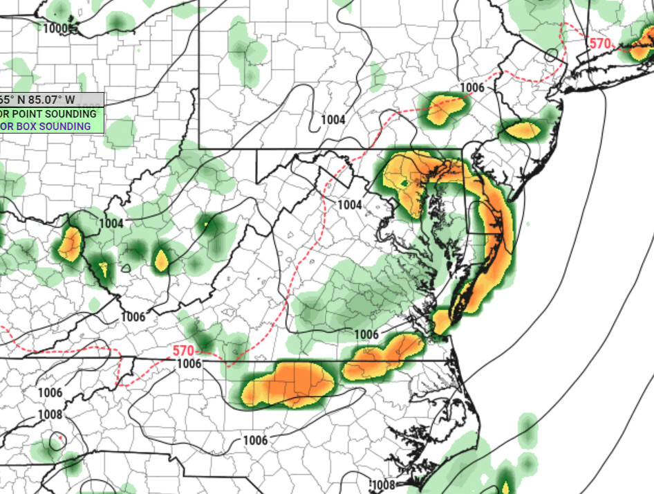
- 2,785 replies
-
- 5
-
-
- severe
- thunderstorms
- (and 3 more)
-
2023 Mid-Atlantic Severe Wx Thread (General Discussion)
Kmlwx replied to Kmlwx's topic in Mid Atlantic
Unfortunately these days it feels like marginal is the new general thunder, slight is the new SEE TEXT and so forth. I honestly think we will see even fewer moderate risk days in our region with the introduction of the enhanced category. -
2023 Mid-Atlantic Severe Wx Thread (General Discussion)
Kmlwx replied to Kmlwx's topic in Mid Atlantic
Here's a screenshot of part of the wind profile from a 12z NAM nest sounding for Monday afternoon - SRH has increased on modeling too it seems.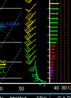
- 2,785 replies
-
- 1
-
-
- severe
- thunderstorms
- (and 3 more)
-
2023 Mid-Atlantic Severe Wx Thread (General Discussion)
Kmlwx replied to Kmlwx's topic in Mid Atlantic
12z NAM (12km) has some beefy soundings in the area for Monday. Timing (at least for now) looks good - I'm onboard (for now)- 2,785 replies
-
- 2
-
-
- severe
- thunderstorms
- (and 3 more)
-
2023 Mid-Atlantic Severe Wx Thread (General Discussion)
Kmlwx replied to Kmlwx's topic in Mid Atlantic
From a superstitious weenie standpoint...I'll take it. Last thing we need is a D3 slight or enhanced going to crap.- 2,785 replies
-
- 1
-
-
- severe
- thunderstorms
- (and 3 more)
-
2023 Mid-Atlantic Severe Wx Thread (General Discussion)
Kmlwx replied to Kmlwx's topic in Mid Atlantic
12z CIPS run roundup - At the 84hr timeslot, on the domain/sector that is most aligned with our area, most analogs don't have much for our area. Last analog #15 is June 1/2, 2012. If you use the box that is still relevant to us but a little further west, that June 1/2, 2012 analog goes to #12. A few analogs on there as well that got us some severe. Hour 108 has July 23, 2008 (will have to look that up) and a bunch of more toned down events. Interestingly - there's a few analogs that were seemingly minor events but centered on or near the Mid-Atlantic.- 2,785 replies
-
- 1
-
-
- severe
- thunderstorms
- (and 3 more)
-
A rumble of thunder or two here - heavy rain now in Colesville, MD
-
2023 Mid-Atlantic Severe Wx Thread (General Discussion)
Kmlwx replied to Kmlwx's topic in Mid Atlantic
I'm going to sound like a broken record - but we have tossed around this discussion in the past - anecdotally I remember a lot more "solid squall lines" in the 90s and earlier 2000s and severe events since then have seemed to be more shorter line segments or more spotty. Interesting that some of the analogs have had a lot of 1990s events in the mix - and that looks like a pretty long/solid line portrayed on the GFS. Again - just me with my pointless musings.- 2,785 replies
-
- 1
-
-
- severe
- thunderstorms
- (and 3 more)
-
2023 Mid-Atlantic Severe Wx Thread (General Discussion)
Kmlwx replied to Kmlwx's topic in Mid Atlantic
12z GFS suggests best mid-level lapse rates go mostly south of DC. But sim reflectivity panels still look excellent - damn impressive for a model that isn't the short range/higher res stuff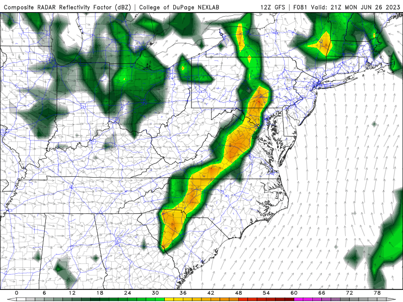
- 2,785 replies
-
- 1
-
-
- severe
- thunderstorms
- (and 3 more)
-
Thinking like you is either a really good sign (weather smarts) or a really bad sign (total weather cynic). It's definitely not as prolific as June 2006 - but just how the "band" of precip is moving - almost the anniversary too!
-
I just pulled up the radar from June 26, 2006 - nowhere near as widespread (I figured) but again - it's a loose match.
-
Not saying it will be anything close to (it won't be) this event - but the radar at this moment reminds me a bit of June 2006...downpours lining up on a SSW-->NNE trajectory.
-
2023 Mid-Atlantic Severe Wx Thread (General Discussion)
Kmlwx replied to Kmlwx's topic in Mid Atlantic
Latest GFS runs have backed off a bit on the quality of the remnant EML. That said - we do have a Day 4 15% outlook area from SPC for portion of the region. -
2023 Mid-Atlantic Severe Wx Thread (General Discussion)
Kmlwx replied to Kmlwx's topic in Mid Atlantic
Impressive sim reflectivity signal on the 18z GFS for Monday afternoon/evening.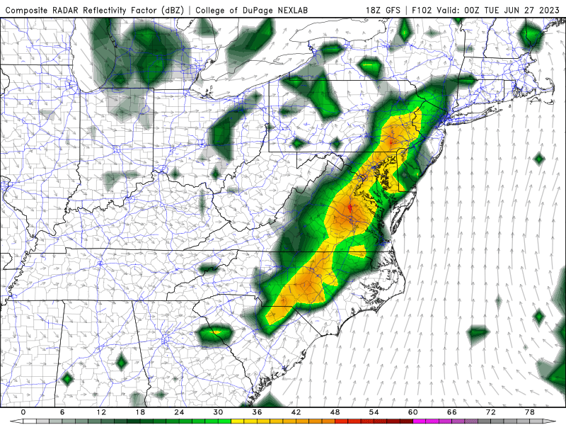
- 2,785 replies
-
- 3
-
-
- severe
- thunderstorms
- (and 3 more)
-
2023 Mid-Atlantic Severe Wx Thread (General Discussion)
Kmlwx replied to Kmlwx's topic in Mid Atlantic
12z CIPS guidance has decent severe signal at 84, 108 AND 132. Best threat window we've had all year. June 4, 2008 is now the top analog on the 84hr frame! (for our domain/sector) June 1, 2012 is showing up in the analog mix at the 108hr mark as well - though not one of the higher analogs.- 2,785 replies
-
- 3
-
-

-
- severe
- thunderstorms
- (and 3 more)
-
2023 Mid-Atlantic Severe Wx Thread (General Discussion)
Kmlwx replied to Kmlwx's topic in Mid Atlantic
The CIPS analogs from the 0z suite had some decent ones mixed in. I saw June 4, 2008 lol- 2,785 replies
-
- 2
-
-
- severe
- thunderstorms
- (and 3 more)
-
2023 Mid-Atlantic Severe Wx Thread (General Discussion)
Kmlwx replied to Kmlwx's topic in Mid Atlantic
You're in here talking dirty to the severe weenies... Paging @Eskimo Joe - get us an EML and we can be sub-par on some other factors and still perform. -
2023 Mid-Atlantic Severe Wx Thread (General Discussion)
Kmlwx replied to Kmlwx's topic in Mid Atlantic
CIPS had a decent severe potential signal on the 168hr frame on the 0z suite.- 2,785 replies
-
- 1
-
-
- severe
- thunderstorms
- (and 3 more)
-
I might be misremembering - but I think the last time LWX was down for either part of SLEP or a major failure - we all thought it was going to be like a 10 day outage and it was back up on like the 6th day or something.
-
It figures that we start to see a potential uptick in severe potential in the coming days to next week while the LWX radar is down...Thanks for the answer! I also feel like they tend to work very fast on these - NWS ROC seems to underpromise and overdeliver at least in my experience with repair timelines. I'm guessing we could see it back in service early if the weather cooperates.
-
2023 Mid-Atlantic Severe Wx Thread (General Discussion)
Kmlwx replied to Kmlwx's topic in Mid Atlantic
Yep! I see we got a bit of a mention in the D4-8 outlook.- 2,785 replies
-
- 2
-
-
- severe
- thunderstorms
- (and 3 more)
-
I'm mainly using TIAD. Seems the feed from TBWI has been thready at best the last few weeks - lots of downtime. TDCA seems to miss some stuff over me - and I wonder if it's because it's a lower elevation versus areas to the west. Can the KLWX radar maintenance proceed even during rain?
-
737-500 I believe. At least that's what showed up on the website.
