

Kmlwx
-
Posts
13,549 -
Joined
-
Last visited
Content Type
Profiles
Blogs
Forums
American Weather
Media Demo
Store
Gallery
Everything posted by Kmlwx
-

2023 Mid-Atlantic Severe Wx Thread (General Discussion)
Kmlwx replied to Kmlwx's topic in Mid Atlantic
100% agreed. Despite the other radars being obviously worse than LWX for many areas - it is great having so many failovers. -
2023 Mid-Atlantic Severe Wx Thread (General Discussion)
Kmlwx replied to Kmlwx's topic in Mid Atlantic
Despite the terminal radars, not having the KLWX radar has been a major detriment. Nonetheless - looking at the KDOX radar seems to show a decent (albeit messy) cluster of storms forming. Seems many areas that missed out yesterday should at least pickup some thunder and rainfall if sub-severe. -
2023 Mid-Atlantic Severe Wx Thread (General Discussion)
Kmlwx replied to Kmlwx's topic in Mid Atlantic
PWS picking up lightning now. 5 strikes so far today. At least we'll get some rain! -
2023 Mid-Atlantic Severe Wx Thread (General Discussion)
Kmlwx replied to Kmlwx's topic in Mid Atlantic
Really it's just because you yelled.- 2,785 replies
-
- 4
-

-

-

-
- severe
- thunderstorms
- (and 3 more)
-
2023 Mid-Atlantic Severe Wx Thread (General Discussion)
Kmlwx replied to Kmlwx's topic in Mid Atlantic
DCAPE is seemingly always a factor that performs for us even in potentially marginal events.- 2,785 replies
-
- 2
-
-
- severe
- thunderstorms
- (and 3 more)
-
2023 Mid-Atlantic Severe Wx Thread (General Discussion)
Kmlwx replied to Kmlwx's topic in Mid Atlantic
HRRR looks semi decent for at least storms today - severity to be determined.- 2,785 replies
-
- 2
-
-
- severe
- thunderstorms
- (and 3 more)
-
2023 Mid-Atlantic Severe Wx Thread (General Discussion)
Kmlwx replied to Kmlwx's topic in Mid Atlantic
lol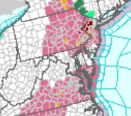
- 2,785 replies
-
- 3
-
-
- severe
- thunderstorms
- (and 3 more)
-
2023 Mid-Atlantic Severe Wx Thread (General Discussion)
Kmlwx replied to Kmlwx's topic in Mid Atlantic
Actually pretty amusing to see the storm tracks. The ones in PA are heading almost straight north, while the stuff that was in VA is heading east. Would have been tough to draw up a more perfect DC screwjob.- 2,785 replies
-
- 1
-
-
- severe
- thunderstorms
- (and 3 more)
-
2023 Mid-Atlantic Severe Wx Thread (General Discussion)
Kmlwx replied to Kmlwx's topic in Mid Atlantic
LWX must have turned on a storm repellent while the radar was down. I did see a single drop of rain (but it may have been a bird pissing) when I got out of the car coming home from work. That's about what today amounted to IMBY.- 2,785 replies
-
- 2
-
-
- severe
- thunderstorms
- (and 3 more)
-
Link to a Tweet with a map - the map claims 50 states...but literally not a peep has been announced for anything over the DMV region. I guess if I have to haul my butt up to Gettysburg...you'd think if they were going to make a very public showing all of this event...they'd make it easier to see. Even the PA one just has a sectional map showing the flight path and a general announcement that it will be over the PA State House at noon. Not helpful.
-
2023 Mid-Atlantic Severe Wx Thread (General Discussion)
Kmlwx replied to Kmlwx's topic in Mid Atlantic
Yeah - radar looks awful for many of us. That Ellicott City cell is okay -
2023 Mid-Atlantic Severe Wx Thread (General Discussion)
Kmlwx replied to Kmlwx's topic in Mid Atlantic
Too early to tell how it will play out - but @Eskimo Joe's call of below I-66 event is looking money if those radar trends continue (looking at TIAD and seeing most stuff focused S of 66. ) -
2023 Mid-Atlantic Severe Wx Thread (General Discussion)
Kmlwx replied to Kmlwx's topic in Mid Atlantic
TIAD is updating fine for me in Radarscope on Mac- 2,785 replies
-
- 1
-
-
- severe
- thunderstorms
- (and 3 more)
-
2023 Mid-Atlantic Severe Wx Thread (General Discussion)
Kmlwx replied to Kmlwx's topic in Mid Atlantic
85/71 back home in Colesville, MD per the PWS. -
2023 Mid-Atlantic Severe Wx Thread (General Discussion)
Kmlwx replied to Kmlwx's topic in Mid Atlantic
Too bad we can't have a 19, 20, and 21z sounding too. -
2023 Mid-Atlantic Severe Wx Thread (General Discussion)
Kmlwx replied to Kmlwx's topic in Mid Atlantic
Remember, though - EJ is more of a mid-level lapse rate guy.- 2,785 replies
-
- 1
-
-
- severe
- thunderstorms
- (and 3 more)
-
2023 Mid-Atlantic Severe Wx Thread (General Discussion)
Kmlwx replied to Kmlwx's topic in Mid Atlantic
Any rotation at range should be taken with a grain of salt - you're seeing a higher level of the storm than you would be if the radar was closer. -
2023 Mid-Atlantic Severe Wx Thread (General Discussion)
Kmlwx replied to Kmlwx's topic in Mid Atlantic
I figured somebody already had it ready to go- 2,785 replies
-
- 1
-
-
- severe
- thunderstorms
- (and 3 more)
-
2023 Mid-Atlantic Severe Wx Thread (General Discussion)
Kmlwx replied to Kmlwx's topic in Mid Atlantic
Oh how I love you guys.- 2,785 replies
-
- 2
-
-
- severe
- thunderstorms
- (and 3 more)
-
2023 Mid-Atlantic Severe Wx Thread (General Discussion)
Kmlwx replied to Kmlwx's topic in Mid Atlantic
Are you *trying* to get us to call you old?- 2,785 replies
-
- 2
-
-
-
- severe
- thunderstorms
- (and 3 more)
-
2023 Mid-Atlantic Severe Wx Thread (General Discussion)
Kmlwx replied to Kmlwx's topic in Mid Atlantic
Bring us home!- 2,785 replies
-
- 1
-
-
- severe
- thunderstorms
- (and 3 more)
-
2023 Mid-Atlantic Severe Wx Thread (General Discussion)
Kmlwx replied to Kmlwx's topic in Mid Atlantic
At work in Potomac/Rockville - but PWS at home is showing 81.7 temp and 72.2 dew. At least for the moment - MBY at home is still okay on the dew side of things. -
2023 Mid-Atlantic Severe Wx Thread (General Discussion)
Kmlwx replied to Kmlwx's topic in Mid Atlantic
It's almost like a pity meso disguised as a good one -
2023 Mid-Atlantic Severe Wx Thread (General Discussion)
Kmlwx replied to Kmlwx's topic in Mid Atlantic
Bold probs! -
2023 Mid-Atlantic Severe Wx Thread (General Discussion)
Kmlwx replied to Kmlwx's topic in Mid Atlantic
Pretty abysmal hail risk in our region now on the probs, however. Enhanced for wind still, of course. The SPC discussion is a little meh worthy honestly.