

Albedoman
-
Posts
1,379 -
Joined
-
Last visited
Content Type
Profiles
Blogs
Forums
American Weather
Media Demo
Store
Gallery
Everything posted by Albedoman
-

January 25-26 Winter Storm Potential
Albedoman replied to Ralph Wiggum's topic in Philadelphia Region
the media pressure will be too much or model agreement will have to be stupendous and overwheelming once the GFS comes on board. I am concerned with the severe cold afterwards not the amounts of precip. You have an entire generation of drivers that have never driven on powdery snow that is compacted into 4 inches of solid ice with no salt to melt as temps in the single digits. The region better keep the truck drivers off the interstates or we all see 100 car pileups. As an old timer, this situation with the cold though not as severe as 1994 reminds of one thing friends Just look at where everything is lined up in this weather channel video see below The 1994 ice storm (specifically the January 7–8 event) effectively paralyzed the Lehigh Valley, turning routine travel and daily activities into significant hazards. Transportation Impacts Road Closures and Accidents: Freezing rain transformed roads into "ice skating rinks," leading to hundreds of accidents across southeastern Pennsylvania. A notable 16-vehicle pileup occurred on westbound Interstate 78 in Lower Saucon Township due to the sudden icing. Stranded Vehicles: Many motorists were forced to abandon cars on snow- and ice-covered highways. Public transit, including some Greyhound bus services, was suspended, leaving travelers stranded at terminals. Public Transit Standstill: Regional transit systems like SEPTA and Amtrak faced major delays or complete shutdowns, with some services taking nearly a week to return to normal. Airport Disruptions: Lehigh Valley International Airport (then ABE) and other regional hubs like Philadelphia International faced multi-day closures due to icy runways. Impacts on Daily Life Widespread Power Outages: Heavy ice accumulation—up to 1 inch—downed thousands of trees and utility lines. Approximately 400,000 to 590,000 customers in the broader region lost power, with many remaining in the dark for over a week. School and Business Closures: Schools across the Lehigh Valley were closed for multiple days. In some instances, schools that attempted to open had to send students home early as conditions worsened, leading to buses becoming stranded on rural roads. Supply Shortages: Panic buying led to severe shortages of staple items; locals reported that "not a loaf of bread" could be found in some city stores. Hardware stores quickly sold out of generators, kerosene, and salt. Hazardous Conditions: Falling tree limbs and "snapping" sounds like gunshots were common as the weight of the ice became too great for trees to bear. Walking outdoors became extremely dangerous due to the thick coating of ice on sidewalks. Infrastructure Failures: The extreme cold and heavy precipitation during this period contributed to the eventual collapse of the Corporate Plaza building in Allentown due to a massive sinkhole -
January 25-26 Winter Storm Potential
Albedoman replied to Ralph Wiggum's topic in Philadelphia Region
I am not too worried yet. Its dry like this on average years during this time frame. Concerns: 1. Being a neutral year, we are in for a real cold and snowy winter which will definitely help the groundwater tables. See lots of northeaster's and the potential freezing rain/sleet events early in December. Expecting some nice rains by mid October as the warm pattern breaks down. A good tropical storm up the east coast can really help get us out this stubborn pattern. Said this Nov 23 The models have shown only one positive thing in the last two weeks for a major pattern change and a possible major snow event for us but when it will ever occur will just be plain luck. If you old timers recognize the current major pattern shift on the last weeks runs which we have not seen in nearly 6-10 years is identified as the four corner lows which are developing and pushing into the Gulf of America. Then these lows are quickly re-energized with a ton of moisture and are setting up for a good Miller A type of storm event- rain or snow along the east coast. The lows south of New Orleans into Tampa are impressive on the model runs. This is the best look in model runs in a long time as it appears the GOA is opening back up for business, however these low pressure systems are also quickly becoming southern sliders too. The cold dry air that does come through with a cold front is NOT retreating back up into Canada so quickly before the moisture reaches us. Would not be surprised if the Carolina's up to Washington DC sees more accumulating snow then us this year. -
January 25-26 Winter Storm Potential
Albedoman replied to Ralph Wiggum's topic in Philadelphia Region
NAM at 48-56 hours HRRR at 36 to tighten it up. Thursday evening will tell us all what is going to happen, The watches should be out by then -
E PA/NJ/DE Winter 2025-26 Obs/Discussion
Albedoman replied to LVblizzard's topic in Philadelphia Region
This looks promising for the LV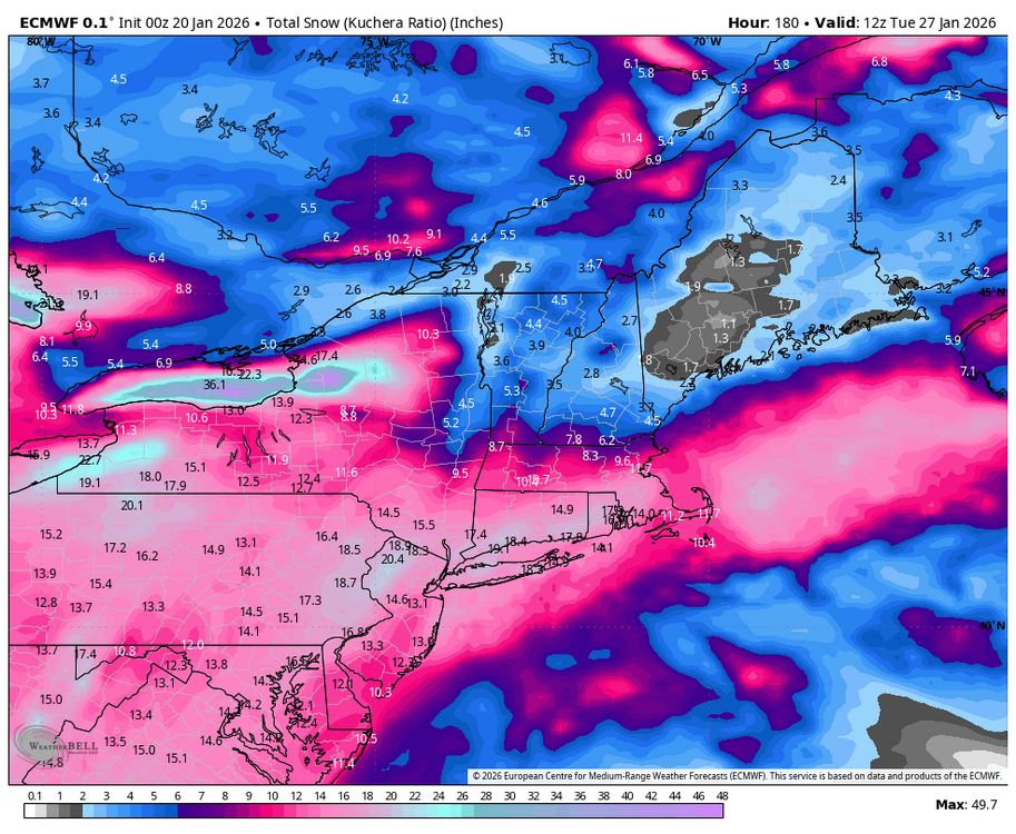
-
E PA/NJ/DE Winter 2025-26 Obs/Discussion
Albedoman replied to LVblizzard's topic in Philadelphia Region
the kicker energy to the north in Canada will pull likley the storm north and the HP over southern Quebec will alsoweaken. This will come to fruition after the missing/scant W PAC data is finally ingested into the Meso models by Thursday 12Z runs Magical points to look for for a MECS/HECS 1. a 1035mb high over southern quebec - we have that, 2. the LP over SW VA with a secondary LP forming directly over the NC Hatteras area- starting to take shape in the last model runs, 3. The secondary LP taking it sweet ass time getting to the Delmarva pennisula-- the sweet spot/Bench mark as the primary LP in W dies on the grapevine do not know yet and 4. An inverted trough setting ip with the LP going negative tilt setting up just off the NJ coast at at least 980 mb --do not know yet Until than trust nothing from social media BS meteorologists. If the 12Z runs on Thursday show something, then Friday winter storm watches should be flowing out. Possible warnings with this storm by the OZ meso runs on Sat if indeed this scenerio unfolds including just about everything in the NWS winter kitchen weather warnings cabinet including freezing spray, blizzard warnings as that criteria will easily be met with the extreme cold but no high winds may prevent them from being issued, Wind chill warnings, cold advisories, ice storm warnings, beach erosion etc, PA NJ and NY would issue state of emergencies Sat morning, major interstates will be shutdown Sat night- the entire winter kitchen cabinet will be emptied folks. Still to early, but I bet your ass that PEMA is looking at this situation right now as the PJM grid system will take a hell of hit too with below zero temps for highs after storm departs. FWIW from the drought guy who has seen every nasty storm in the last 45 years here. -
E PA/NJ/DE Winter 2025-26 Obs/Discussion
Albedoman replied to LVblizzard's topic in Philadelphia Region
Let it hone in Ralph. I said many weeks ago what was going to happen around MLK and dam if it did. Nearly a foot of snow on the ground at my house. Now comes the blistering cold that you will will remember I stated back last Novmeber which I go lambasted for. The storm for this weekend is going to flip flop until the PAC data comes into play by Thursday afternoon. Anything on the mid range models is horse shit IMHO, the models are all are missing vital data. Fun storm to track but if th cold is as deep as shown for thweekend, supression will likley win out. Snow in the teens will be nasty as even salt will not work should be the big headline. Travell could be SOB. Be prepared to huncker down this weekend would be motto if the storm comes north. Personally another 4-6 inches is good enough for me but blowing that shit at 12 degrees is not fun. -
January 18th Back Door NW Trend Snow OBS Thread
Albedoman replied to Mikeymac5306's topic in Philadelphia Region
I agree- way too conservative and Bobby has not the experience of storms like this. This sscenario happens only a few times in a decade. In his next breath, he will now call this an overperformer- in whose eyes though?- not mine. I called it for my township on the nose. -
January 18th Back Door NW Trend Snow OBS Thread
Albedoman replied to Mikeymac5306's topic in Philadelphia Region
yep I have just about 3 inches today. 9 inches in 24 hours- I will take. I am not cleaning this stuff until I see what happens this evening- it maybe all for naught. Could have 12 inches by this evening from this two day storm event on the ground the way these storms are going. Somone in the NE is going to get whacked with a norlun trough still. -
E PA/NJ/DE Winter 2025-26 Obs/Discussion
Albedoman replied to LVblizzard's topic in Philadelphia Region
close to a norlun trough yoou never know when tilts lol -
E PA/NJ/DE Winter 2025-26 Obs/Discussion
Albedoman replied to LVblizzard's topic in Philadelphia Region
final total 5.8 at my house Overperformer fo sure. I am becoming real concern that tommorrows snow is going into a negative tilt with someone getting a norlun trough situation from eastern pa up to Conn area. another 4-6 inches is not out of the realm right now if you believe the NAM run at noon. Winter storm watches maybe issued -
E PA/NJ/DE Winter 2025-26 Obs/Discussion
Albedoman replied to LVblizzard's topic in Philadelphia Region
Pushing 6 in here now Macungie. Overperformer fo sure -
E PA/NJ/DE Winter 2025-26 Obs/Discussion
Albedoman replied to LVblizzard's topic in Philadelphia Region
I have nearly 4 inches on the ground here in Macungie. Puking snow I said after the 15th and near the 22nd weeks ago. Hit it good on the prediction back in December. Actually will have to bring out my snow thrower - have not done that in almost year -
E PA/NJ/DE Winter 2025-26 Obs/Discussion
Albedoman replied to LVblizzard's topic in Philadelphia Region
I posted this on the 12/27 Winter is going to take a brief break after this BS first of the year storm of only 1-3 inches if we are really lucky. I see no snowstorms until after the 15th and it will warm up into the upper 40's to 50's . I do think we will pay the piper for this brief warm up by Marin Luther Kings day-- seems to be the pattern the last 5 years. All I can say is the drought situation in our area is only going to worsen as the Gulf storm production is shut down for business. Believe me, dried up wells and sinkhole formation with dropping groundwater tables with waterline breaks galore will be the talk of the town in the next three weeks as the ground starts to thaw out with what little moisture is in it. The base flows of the creeks will begin to drop again too. We really need a 96 type of storm event asap. Still holding-------- -
E PA/NJ/DE Winter 2025-26 Obs/Discussion
Albedoman replied to LVblizzard's topic in Philadelphia Region
Mods should set as separate policy on starting new storm threads. For example- The innitial storm post must be shown on at least 2 of the the SR models at 3 days to be an immediate posting. On the LR range models the storm must be shown between 5-7 days on the at least two of the models such as GFS, CMC and or Euro IN AT LEAST TWO CONSECTUTIVE DAILY RUNS. Anything else out further than 7 days is BS and is not immediate. The problem is that the media and youtube hucksters out there pick up one model run 10-15 days out and run with it like it is a major crisis unfolding, like the polar vortex, one Noreaster pattern etc. They are ruining the relaibility of the forecasters on this site right now too. Hyped media is selling the weather story and not professional forecasting. I welcome comments, especially from the long timers here. -
E PA/NJ/DE Winter 2025-26 Obs/Discussion
Albedoman replied to LVblizzard's topic in Philadelphia Region
ralph, For the first time in probably 3-5 years, we have an ARKLATEX low forming on the CMC model at the end of the run. For those youngsters who do not know how real weathermen used to forecast without relying on these crappy models, this type of LP forming forming in this location is harbinger of a major 6-12+ incher snowstorm for our region for a good 75% of the time. Its nice to see one even show up and my forecast of not until the 15th-19th period for a major winter storm could tumble. This is the first track able storm that may realize some good accumulating snow if the Quebec high and blocking are in place. -
Boxing Night Snow/Sleet/Ice Dec 26-27 Storm Thread/Obs.
Albedoman replied to Mikeymac5306's topic in Philadelphia Region
Winter is going to take a brief break after this BS first of the year storm of only 1-3 inches if we are really lucky. I see no snowstorms until after the 15th and it will warm up into the upper 40's to 50's . I do think we will pay the piper for this brief warm up by Marin Luther Kings day-- seems to be the pattern the last 5 years. All I can say is the drought situation in our area is only going to worsen as the Gulf storm production is shut down for business. Believe me, dried up wells and sinkhole formation with dropping groundwater tables with waterline breaks galore will be the talk of the town in the next three weeks as the ground starts to thaw out with what little moisture is in it. The base flows of the creeks will begin to drop again too. We really need a 96 type of storm event asap. -
Boxing Night Snow/Sleet/Ice Dec 26-27 Storm Thread/Obs.
Albedoman replied to Mikeymac5306's topic in Philadelphia Region
This is my typical old fart storm. Yes I agree toss the NAM. This is why 35 years + of experience is also telling me like what I posted on your facebook site today---This is a strictly a soundings location event. Biggest take away- watch for those fatty pancake flakes to accumulate quickly right before the changeover to sleet. The snow winner will be wherever the zero line does not get penetrated and those pancake flakes do not changeover to sleet. LV will be in the thick of it. Elevation means squat in this event for the LV, its where the warm nose tongue aloft sticks out. Hope it shows its tongue as far west as Reading only, then the LV will see 8-12 in. Seen it before. -
Boxing Night Snow/Sleet/Ice Dec 26-27 Storm Thread/Obs.
Albedoman replied to Mikeymac5306's topic in Philadelphia Region
add 3-5 inches to the snow totals in the purple and state that sleet totals maybe bring the final totals down and you would be spot on -
Boxing Night Snow/Sleet/Ice Dec 26-27 Storm Thread/Obs.
Albedoman replied to Mikeymac5306's topic in Philadelphia Region
throw this map out. No way does this storm produce the mixed lines like this. None of these boundary lines follows physical geography. What a waste. Historical weather patterns in my lifetime point to the evolution of the storm producing pingers in the last two hours of the storm event, then to a quick shot of freezing rain and then the final cake frosting of freezing drizzle in the LV with a normal thump of 6-8 inches of snow. That is a safe bet right now. All I can say is it will be one hell of back breaking shoveling event. Snow blower special indeed., Under a winter storm watch now too -
E PA/NJ/DE Winter 2025-26 Obs/Discussion
Albedoman replied to LVblizzard's topic in Philadelphia Region
yep fully aware. I am the Township manager for Lowhill Township. Down and dead ash trees the last year I have been an absolute nightmare for my public works dept. Just as much of nightmare is the traffic signal timing that you have to deal with on Rt 100 for your water deliveries. Working on that too. -
E PA/NJ/DE Winter 2025-26 Obs/Discussion
Albedoman replied to LVblizzard's topic in Philadelphia Region
I seen so much wind this year== whats another day. I am waiting for the flash freeze from a dusting of snow to appear by tomorrow evening. -
E PA/NJ/DE Winter 2025-26 Obs/Discussion
Albedoman replied to LVblizzard's topic in Philadelphia Region
E PA/NJ/DE Autumn 2025 Obs/Discussion Albedoman replied to PhiEaglesfan712's topic in Philadelphia Region in October My forecast did suggest a slow start. Enjoy the fall weather while you can. Come january you will be wishing for temps above 45 . I expect more mix events than anything else in late nov into mid dec as the pattern sets up for january------- well I was pretty close. We will get 1-2 days this week above 45 degrees. Thank god it will melt the .50 in of snow equivalent liquid precip with the expected 1-2 inches of rain. That will help the drought somewhat for the stream base flows but the main problem is that the frost in the soil horizon is already pretty deep especially in the LV. The groundwater is likely not going to be recharged at all. You will see real muddy conditions in the yard for a few days as the topsoil is unfrozen, but then back into the deep freeze. I would love to see t storms Thursday night. The snow will quickly disappear with sublimation from fog and from the heavy rain. The down trees on Friday will be a huge problem from the winds as the soils around the tree roots will soften up just enough to be wind thrown before freezing. Main concern for me, if it rains hard enough Friday afternoon, the expected winds may not dry our the road surfaces from the excessive ponding and we will have flash freeze conditions Friday evening in many areas. Saturday morning may not be very nice around our region. Also, my utility bill is doubled from last year according to my usage and I still have have a 15 days to go. Going to be many homeowners wishing they had not spent so much on Christmas gifts come mid January when they get their utility bill. This chart says it all just posted by Mt Holly. -
E PA/NJ/DE Winter 2025-26 Obs/Discussion
Albedoman replied to LVblizzard's topic in Philadelphia Region
January 6-8 1996 happened you should not have forgotten about that? -
Saturday night/Sunday 12/13-12/14 Jawn
Albedoman replied to Ralph Wiggum's topic in Philadelphia Region
Thats what physical geography can do with the South Mountain Range to the SE and the Blue Mt to the north. Adiabatic winds in banding snows is just like t- storms in the summer coming over the mts and hills and getting blown apart too. Sorry for your loss. SE Lehigh County and much of northern and central Chester Montgomery Bucks Counties was the jackpot area where the heavier band stayed together near the downslope side of S. Mtn and dropped additional precip. Northern Lehigh County had only 3-5 inches because of the way this storm traveled too. I am sure the final snow map from Mt Holly will clearly demonstrate this too -
Saturday night/Sunday 12/13-12/14 Jawn
Albedoman replied to Ralph Wiggum's topic in Philadelphia Region
ABE had officially 5 inches - just reported. Here at my house- nearly 7 inches. South Mountain Screamer for sure. From eastern Chester, Berks , Lehigh, Bucks, Northampton and into NJ all along the South Mountain Range and especially elevation driven - anywhere from 5- 8 inches of snow- take your pick. Geography rules folks. NOUS41 KPHI 141536PNSPHIDEZ001>004-MDZ012-015-019-020-NJZ001-007>010-012>027-PAZ054-055-060>062-070-071-101>106-150336-Public Information StatementNational Weather Service Mount Holly NJ1036 AM EST Sun Dec 14 2025...SNOWFALL REPORTS AS OF 1030 AM...Location Amount Time/Date Provider ...Delaware......Kent County...Smyrna 3.5 SSW 2.0 in 0700 AM 12/14 COCORAHS Clayton 1.5 SW 2.0 in 0730 AM 12/14 COCORAHS Cheswold 2.0 in 0900 AM 12/14 Broadcast Media 3 SW Magnolia 1.4 in 0900 AM 12/14 Public Harrington 2 ENE 0.5 in 0900 AM 12/14 COCORAHS ...New Castle County...Bear 6.8 in 0950 AM 12/14 Broadcast Media Hockessin 6.0 in 0710 AM 12/14 Public Wilmington 5.6 N 5.4 in 0700 AM 12/14 COCORAHS Newark 3.9 SSW 4.6 in 0700 AM 12/14 COCORAHS Newark 1.5 S 4.0 in 0720 AM 12/14 COCORAHS Newark 3.9 in 0950 AM 12/14 Broadcast Media Middletown 4.9 NW 3.8 in 0700 AM 12/14 COCORAHS Middletown 3.8 in 0730 AM 12/14 Trained Spotter New Castle County Airport 3.3 in 0700 AM 12/14 ASOS Newport 2.4 WNW 3.3 in 0700 AM 12/14 COCORAHS ...Sussex County...Seaford 2.3 SSE 0.9 in 0800 AM 12/14 COCORAHS Bridgeville 2.6 W 0.5 in 0700 AM 12/14 COCORAHS Seaford 0.5 in 0700 AM 12/14 COCORAHS 3 ESE Bridgeville 0.5 in 0800 AM 12/14 COCORAHS ...Maryland......Kent County...Chestertown 4.0 in 0850 AM 12/14 Trained Spotter Worton 3.9 NW 3.6 in 0700 AM 12/14 COCORAHS Rock Hall 3.0 in 0800 AM 12/14 Trained Spotter ...Queen Annes County...4 SW Chester 1.0 in 0642 AM 12/14 Public ...New Jersey......Atlantic County...Hammonton 4.0 in 0905 AM 12/14 CO-OP Observer Ventnor City 2.5 in 0903 AM 12/14 Public Estell Manor 1.1 in 0800 AM 12/14 COOP Brigantine 0.9 ESE 1.0 in 0800 AM 12/14 COCORAHS Atlantic City International 0.6 in 0700 AM 12/14 ASOS Linwood 0.7 NNE 0.5 in 0700 AM 12/14 COCORAHS ...Burlington County...Moorestown 7.0 in 0800 AM 12/14 COCORAHS Mount Laurel 5.8 in 0815 AM 12/14 Public Burlington 1.7 E 5.8 in 0835 AM 12/14 COCORAHS Medford Lakes 4.8 in 0830 AM 12/14 COCORAHS Evesham 4.2 S 3.8 in 0700 AM 12/14 COCORAHS Mount Holly WFO 3.6 in 0700 AM 12/14 Official NWS Obs Mount Laurel 3.6 in 0700 AM 12/14 COCORAHS Westampton 3.6 in 0700 AM 12/14 COOP Willingboro Twp 1.3 ESE 3.4 in 0700 AM 12/14 COCORAHS 1 NNE Rancocas 3.4 in 0728 AM 12/14 NWS Employee 2 NW South Jersey Regional A 3.1 in 0630 AM 12/14 NWS Employee Wrightstown 3.0 in 0601 AM 12/14 Public Mount Laurel Twp 3.9 NE 3.0 in 0630 AM 12/14 COCORAHS Medford 1.0 in 0614 AM 12/14 Public ...Camden County...Haddon Township 5.7 in 0840 AM 12/14 Trained Spotter Pennsauken 5.7 in 0930 AM 12/14 Trained Spotter Barrington 0.8 NE 3.3 in 0730 AM 12/14 COCORAHS Winslow Twp. 3.5 W 3.1 in 0715 AM 12/14 COCORAHS 2 SW Chesilhurst 2.3 in 0820 AM 12/14 Trained Spotter ...Cumberland County...Deerfield Twp 2.0 E 1.6 in 0730 AM 12/14 COCORAHS ...Gloucester County...Pitman 5.6 in 0830 AM 12/14 Trained Spotter Washington Twp 5.5 in 0930 AM 12/14 Trained Spotter Greenwich Twp 2.2 ESE 5.0 in 0950 AM 12/14 COCORAHS Monroe Twp 0.6 WNW 4.0 in 1000 AM 12/14 COCORAHS Glassboro 1.6 WNW 3.5 in 0700 AM 12/14 COCORAHS Pitman 0.1 W 3.2 in 0700 AM 12/14 COCORAHS Monroe Twp. 1.8 SE 2.7 in 0800 AM 12/14 COCORAHS ...Hunterdon County...1 WNW Stanton 7.3 in 0930 AM 12/14 Public 1 WNW Pittstown 6.5 in 0815 AM 12/14 Public Frenchtown 0.5 N 6.5 in 0830 AM 12/14 COCORAHS Clinton Twp. 4 N 6.5 in 0845 AM 12/14 COCORAHS Flemington 1.9 SE 6.3 in 0900 AM 12/14 COCORAHS Flemington 2.3 E 6.2 in 0800 AM 12/14 COCORAHS 1 SW Three Bridges 6.2 in 0800 AM 12/14 Trained Spotter Flemington 3 E 6.0 in 0700 AM 12/14 COOP Clinton 6.0 in 0800 AM 12/14 Public 2 ESE Port Murray 6.0 in 0800 AM 12/14 Trained Spotter Flemington 6.0 in 0804 AM 12/14 Amateur Radio Milford 6.0 in 0915 AM 12/14 Public Readington Twp 1.8 ENE 5.9 in 0700 AM 12/14 COCORAHS Lebanon 0.5 E 5.8 in 0800 AM 12/14 COCORAHS Whitehouse Station 5.8 in 0830 AM 12/14 Trained Spotter Holland Twp 2.6 NNE 5.5 in 0700 AM 12/14 COCORAHS Lebanon 2.8 N 5.0 in 0645 AM 12/14 COCORAHS ...Mercer County...Pennington 7.0 in 0855 AM 12/14 Public Trenton Mercer Airport 6.8 in 0815 AM 12/14 CO-OP Observer Hopewell 5.5 in 0700 AM 12/14 COCORAHS Ewing Twp. 5.0 in 0720 AM 12/14 COCORAHS Princeton 2.3 E 4.8 in 0700 AM 12/14 COCORAHS Pennington 1.7 SE 4.5 in 0630 AM 12/14 COCORAHS East Windsor Twp 3.9 in 0700 AM 12/14 Trained Spotter Hamilton Twp 2.6 NNE 3.9 in 0700 AM 12/14 COCORAHS 2 S Mercerville 1.5 in 0616 AM 12/14 Public ...Middlesex County...Cranbury 6.5 in 0900 AM 12/14 Trained Spotter Sayreville 0.9 ENE 5.6 in 0935 AM 12/14 COCORAHS New Brunswick 3 SE 5.4 in 0800 AM 12/14 COOP Edison 5.2 in 0945 AM 12/14 Newspaper New Brunswick 1.8 E 4.8 in 0845 AM 12/14 COCORAHS North Brunswick Twp 1.5 W 3.8 in 0700 AM 12/14 COCORAHS South River 3.8 in 0810 AM 12/14 Trained Spotter 1 NW Concordia 3.5 in 0917 AM 12/14 Trained Spotter Woodbridge 1 ESE 3.1 in 0700 AM 12/14 COCORAHS Woodbridge 3.1 in 0732 AM 12/14 Trained Spotter East Brunswick Twp 3.0 in 0700 AM 12/14 COCORAHS Old Bridge Twp. 5 NE 3.0 in 0700 AM 12/14 COCORAHS Woodbridge Twp. 1 NNE 2.7 in 0600 AM 12/14 COCORAHS ...Monmouth County...Upper Freehold Twp 6.6 in 0912 AM 12/14 Public Upper Freehold Twp. 2.3 S 5.9 in 0830 AM 12/14 COCORAHS Tinton Falls 5.7 in 0912 AM 12/14 Public Freehold 5.0 in 0721 AM 12/14 Trained Spotter Long Branch 5.0 in 0900 AM 12/14 CO-OP Observer Colts Neck Twp 2.4 NW 4.9 in 0845 AM 12/14 COCORAHS Howell Twp 3.7 SSW 3.9 in 0700 AM 12/14 COCORAHS Red Bank 1.9 NNW 3.6 in 0724 AM 12/14 COCORAHS 1 ENE West Long Branch 3.0 in 0730 AM 12/14 Trained Spotter 0.7 SW Long Branch 2.8 in 0630 AM 12/14 COOP Long Branch 0.5 W 2.8 in 0630 AM 12/14 COCORAHS Neptune City 0.1 E 2.5 in 0700 AM 12/14 COCORAHS ...Morris County...Jefferson Twp 3.1 WSW 6.0 in 0800 AM 12/14 COCORAHS Mine Hill Twp. 6.0 in 0815 AM 12/14 COCORAHS 1 SW Netcong 6.0 in 0824 AM 12/14 Trained Spotter Budd Lake 5.8 in 0805 AM 12/14 Public Mount Arlington 5.5 in 0800 AM 12/14 COCORAHS Mendham 3.2 NNW 5.0 in 0700 AM 12/14 COCORAHS Randolph 5.0 in 0850 AM 12/14 Trained Spotter Randolph Twp 2.2 SE 4.9 in 0700 AM 12/14 COCORAHS Rockaway 2.5 N 4.7 in 0830 AM 12/14 COCORAHS Madison 0.8 WSW 4.5 in 0700 AM 12/14 COCORAHS Rockaway 4.5 in 0720 AM 12/14 Public 1 SSW Brookside 4.5 in 0823 AM 12/14 Trained Spotter Mendham 1.5 W 4.4 in 0845 AM 12/14 COCORAHS Butler 0.5 NE 4.2 in 0730 AM 12/14 COCORAHS Chatham 0.6 NE 4.0 in 0700 AM 12/14 COCORAHS Kinnelon 1.4 SE 4.0 in 0800 AM 12/14 COCORAHS Denville Twp 1.5 ESE 3.6 in 0700 AM 12/14 COCORAHS ...Ocean County...1 N Jackson 6.8 in 0913 AM 12/14 Trained Spotter Toms River 5.7 in 0900 AM 12/14 Public 2 N Lavallette 5.1 in 0905 AM 12/14 Trained Spotter Manchester Twp 5.6 NE 4.0 in 0630 AM 12/14 COCORAHS Toms River Twp 4.2 WSW 3.8 in 0700 AM 12/14 COCORAHS 1 WNW Point Pleasant 3.5 in 0930 AM 12/14 Public Point Pleasant Beach 3.2 in 0700 AM 12/14 COCORAHS Berkeley Twp. 2.7 SSE 3.1 in 0700 AM 12/14 COCORAHS 2 E Ocean Acres 3.1 in 0900 AM 12/14 Trained Spotter Toms River Twp 3.1 SSE 3.0 in 0700 AM 12/14 COCORAHS Stafford Twp. 2.1 NW 2.5 in 0800 AM 12/14 COCORAHS Stafford Twp. 2.8 NNW 2.5 in 0800 AM 12/14 COCORAHS Barnegat Twp 2.1 in 0707 AM 12/14 Public Lacey Twp 4.1 ESE 2.0 in 0700 AM 12/14 COCORAHS Brick Twp. 1.5 NNE 0.5 in 0800 AM 12/14 COCORAHS ...Salem County...Woodstown 4.5 in 0830 AM 12/14 Trained Spotter Salem 0.6 ENE 3.8 in 0812 AM 12/14 COCORAHS Pennsville 3.5 in 0638 AM 12/14 Public ...Somerset County...Branchburg Twp 2.0 NE 7.1 in 0800 AM 12/14 COCORAHS Martinsville 7.0 in 0900 AM 12/14 Public Bridgewater 6.6 in 0928 AM 12/14 Trained Spotter Watchung 1.4 WNW 6.5 in 0957 AM 12/14 COCORAHS Franklin Twp 3.8 ENE 6.2 in 0905 AM 12/14 COCORAHS 1 S Manville 6.0 in 0745 AM 12/14 Public Bridgewater Twp 3.3 NW 6.0 in 0800 AM 12/14 COCORAHS Somerville 6.0 in 0800 AM 12/14 Trained Spotter 3 NNW Bridgewater 6.0 in 0836 AM 12/14 Public 1 N Manville 6.0 in 0911 AM 12/14 Public Bernards Twp. 5.6 in 0815 AM 12/14 COCORAHS Bridgewater Twp 0.9 NE 5.2 in 0700 AM 12/14 COCORAHS 1 E Belle Mead 5.0 in 0750 AM 12/14 Trained Spotter Watchung 5.0 in 0755 AM 12/14 Public Bernardsville 4.9 in 0735 AM 12/14 Trained Spotter Manville 4.0 in 0600 AM 12/14 COCORAHS Bernards Twp 0.9 ENE 3.5 in 0700 AM 12/14 COCORAHS ...Sussex County...Stockholm 7.0 in 1010 AM 12/14 Trained Spotter Vernon Twp 3.8 WSW 6.5 in 0700 AM 12/14 COCORAHS Sparta Twp 1.4 SSW 6.5 in 0900 AM 12/14 COCORAHS 1 ENE Hamburg 6.4 in 0845 AM 12/14 Public Sparta Twp 3.3 NW 6.1 in 0831 AM 12/14 COCORAHS Sparta 6.1 in 0910 AM 12/14 Trained Spotter High Point 6.1 in 0915 AM 12/14 Public Newton 7.2 W 6.0 in 0700 AM 12/14 COCORAHS Sparta Twp 3.6 SSW 6.0 in 0700 AM 12/14 COCORAHS Wantage Twp 5.9 in 0730 AM 12/14 Public 4 WSW Wantage Twp 5.8 in 0700 AM 12/14 Trained Spotter 1 WNW Vernon 5.7 in 0645 AM 12/14 COCORAHS 2 NW Vernon 5.7 in 0753 AM 12/14 Trained Spotter Vernon 5.7 in 0800 AM 12/14 Broadcast Media Hardyston Twp 3.2 SE 5.5 in 0730 AM 12/14 COCORAHS Lafayette Twp 5.5 in 0830 AM 12/14 Trained Spotter Montague Twp 2.7 WNW 5.1 in 0700 AM 12/14 COCORAHS ...Warren County...Greenwich Twp 1.6 S 6.3 in 0700 AM 12/14 COCORAHS Hackettstown 5.8 in 0850 AM 12/14 Trained Spotter 2 E Phillipsburg 5.5 in 0700 AM 12/14 Public Washington Twp 2.4 ESE 5.5 in 0700 AM 12/14 COCORAHS Blairstown Twp 2.2 ESE 5.2 in 0700 AM 12/14 COCORAHS 2 SE Mt. Bethel 5.2 in 0700 AM 12/14 COCORAHS Oxford 5.0 in 1000 AM 12/14 Trained Spotter ...Pennsylvania......Berks County...Alburtis 4.7 SW 7.0 in 0700 AM 12/14 COCORAHS Earl Twp 7.0 in 0730 AM 12/14 Trained Spotter New Morgan 1.8 WNW 6.1 in 0800 AM 12/14 COCORAHS Lyons 2.6 SE 6.0 in 0700 AM 12/14 COCORAHS 1 WSW Union Twp 5.8 in 0715 AM 12/14 Public Huffs Church 5.8 in 0755 AM 12/14 Trained Spotter Elverson 2.1 NE 5.5 in 0900 AM 12/14 COCORAHS 1 WSW Amity Gardens 5.4 in 0900 AM 12/14 Public Fleetwood 2 ESE 5.3 in 0700 AM 12/14 COCORAHS Mohnton 2.8 SSW 5.3 in 0800 AM 12/14 COCORAHS Oley 0.9 SSW 5.3 in 0800 AM 12/14 COCORAHS Fleetwood 4.8 ESE 5.0 in 0700 AM 12/14 COCORAHS Hamburg 5.0 in 0700 AM 12/14 COCORAHS Fleetwood 5.0 in 0720 AM 12/14 Trained Spotter 3 ENE New Morgan 5.0 in 0835 AM 12/14 Trained Spotter Mertztown 4.5 in 0830 AM 12/14 Trained Spotter Bernville 1.3 SW 3.3 in 0700 AM 12/14 COCORAHS 1 SSW Sinking Spring 3.1 in 0630 AM 12/14 Public Mohrsville 0.1 W 3.0 in 0700 AM 12/14 COCORAHS Reading 4.7 WSW 3.0 in 0800 AM 12/14 COCORAHS Reading Regional Airport 2.2 in 0700 AM 12/14 ASOS Blandon 2.0 in 0820 AM 12/14 Trained Spotter ...Bucks County...Doylestown 3.4 SW 8.0 in 0800 AM 12/14 COCORAHS Hilltown Twp 7.8 in 0955 AM 12/14 Trained Spotter 1 ESE Tinicum Twp 7.5 in 0837 AM 12/14 Trained Spotter Doylestown 7.3 in 0704 AM 12/14 Trained Spotter Fricks 7.0 in 0700 AM 12/14 COCORAHS Perkasie 0.8 NE 7.0 in 0800 AM 12/14 COCORAHS Souderton 1.4 ENE 7.0 in 0800 AM 12/14 COCORAHS Trumbauersville 7.0 in 0953 AM 12/14 Trained Spotter Newtown 1.6 S 6.0 in 0845 AM 12/14 COCORAHS 1 NNW Langhorne 6.0 in 0950 AM 12/14 Trained Spotter Croydon 0.4 SW 5.2 in 0944 AM 12/14 COCORAHS 1 NW Lahaska 5.2 in 0955 AM 12/14 Trained Spotter Levittown 5.0 in 0711 AM 12/14 Trained Spotter Langhorne 3.4 NNE 3.6 in 0630 AM 12/14 COCORAHS ...Carbon County...Lehigh Twp 8.0 in 0641 AM 12/14 Public Lake Harmony 2.4 WNW 8.0 in 0700 AM 12/14 COCORAHS 1 NE Christmans 8.0 in 0920 AM 12/14 Public Hudsondale 7.0 in 0900 AM 12/14 Public Lehighton 3.3 WSW 5.6 in 0700 AM 12/14 COCORAHS ...Chester County...East Nantmeal Twp 8.8 in 0915 AM 12/14 Public East Nottingham Twp. 8.5 in 0900 AM 12/14 Trained Spotter Malvern 8.0 in 0720 AM 12/14 Public Berwyn 8.0 in 0940 AM 12/14 Public Exton 2.1 SE 7.9 in 0738 AM 12/14 COCORAHS 2 SE Exton 7.9 in 0755 AM 12/14 Trained Spotter Atglen 7.8 in 0700 AM 12/14 Trained Spotter 2 WSW West Sadsbury Twp 7.8 in 0735 AM 12/14 Trained Spotter West Caln Twp 7.5 in 0730 AM 12/14 Public Easttown Twp 7.5 in 0750 AM 12/14 Public Oxford 2.9 SW 7.0 in 0700 AM 12/14 COCORAHS 1 NNW Marshallton 7.0 in 0959 AM 12/14 Public West Chester 2.4 SSE 6.5 in 0700 AM 12/14 COCORAHS Pottstown 3.0 SSE 6.5 in 0730 AM 12/14 COCORAHS East Coventry Twp 6.0 in 0613 AM 12/14 Public Spring City 4.9 W 6.0 in 0800 AM 12/14 COCORAHS Unionville 2.2 NE 5.9 in 0730 AM 12/14 COCORAHS Chads Ford 3 SW 5.2 in 0700 AM 12/14 COCORAHS Chesterbrook 5.0 in 0643 AM 12/14 Public 1 WSW Phoenixville 4.0 in 0844 AM 12/14 Trained Spotter ...Delaware County...1 WSW Bethel Twp 6.5 in 0739 AM 12/14 Trained Spotter Springfield 0.1 NNW 6.0 in 0735 AM 12/14 COCORAHS Upper Chichester 1.4 W 5.5 in 0700 AM 12/14 COCORAHS Morton 4.9 in 0845 AM 12/14 Trained Spotter Aston 4.8 in 0700 AM 12/14 Public Lansdowne 0.4 NE 4.0 in 0920 AM 12/14 COCORAHS ...Lehigh County...Coopersburg 8.0 in 0900 AM 12/14 Trained Spotter Center Valley 7.0 in 0830 AM 12/14 Trained Spotter 1 NW Macungie 6.5 in 0753 AM 12/14 Public Salisbury Twp 6.3 in 0907 AM 12/14 Trained Spotter Wescosville 5.8 in 0628 AM 12/14 Public Allentown 5.6 in 0945 AM 12/14 Trained Spotter 1 NW Schnecksville 5.3 in 0740 AM 12/14 Trained Spotter Schnecksville 1.7 ENE 5.3 in 0800 AM 12/14 COCORAHS Lehigh Valley International 5.0 in 0700 AM 12/14 ASOS Slatington 2.3 SE 4.5 in 0730 AM 12/14 COCORAHS ...Monroe County...Jackson Twp 8.0 in 0900 AM 12/14 Public Delaware Water Gap 6.8 in 0800 AM 12/14 Public Mount Pocono 0.7 N 6.1 in 0700 AM 12/14 COCORAHS Saylorsburg 6.0 in 0830 AM 12/14 Trained Spotter Coolbaugh Twp 5.8 in 1000 AM 12/14 Trained Spotter Arlington Heights 5.0 in 0721 AM 12/14 Trained Spotter Saylorsburg 2.7 ENE 4.0 in 0900 AM 12/14 COCORAHS Canadensis 3.8 in 0700 AM 12/14 COOP ...Montgomery County...Blue Bell 2.3 NW 8.7 in 0927 AM 12/14 COCORAHS 2 NE Worcester Twp 8.5 in 0835 AM 12/14 Public 1 SW Skippack Twp 8.0 in 0800 AM 12/14 Trained Spotter Harleysville 2.1 SW 7.5 in 0731 AM 12/14 COCORAHS Salford Twp 7.5 in 0815 AM 12/14 Trained Spotter West Pottsgrove Twp 7.3 in 0900 AM 12/14 Public Norristown 7.2 in 0845 AM 12/14 Public 1 NE Pottstown 7.1 in 0722 AM 12/14 COCORAHS Pennsburg 2.4 SSW 7.0 in 0700 AM 12/14 COCORAHS New Hanover Twp 7.0 in 0805 AM 12/14 Public 1 SSE Trappe 6.9 in 0900 AM 12/14 Public North Wales 1.3 WSW 6.8 in 0830 AM 12/14 COCORAHS Stowe 6.6 in 0830 AM 12/14 Trained Spotter 1 W Willow Grove 6.4 in 0757 AM 12/14 Trained Spotter Hatboro 0.6 E 6.0 in 0600 AM 12/14 COCORAHS Harleysville 6.0 in 0614 AM 12/14 Public Salford Twp 6.0 in 0800 AM 12/14 Trained Spotter Fort Washington 0.8 NW 6.0 in 0900 AM 12/14 COCORAHS 1 NE Jenkintown 6.0 in 0900 AM 12/14 Trained Spotter Willow Grove 0.6 SW 5.9 in 0800 AM 12/14 COCORAHS Glenside 1.1 NW 5.5 in 0700 AM 12/14 COCORAHS Conshohocken 0.5 N 5.5 in 0830 AM 12/14 COCORAHS 1 ENE Plymouth Twp 5.5 in 0923 AM 12/14 Public King of Prussia 5.2 in 0920 AM 12/14 Trained Spotter Eagleville 5.1 in 0715 AM 12/14 Emergency Mngr Penn Wynne 0.5 NNW 5.0 in 0700 AM 12/14 COCORAHS Willow Grove 0.9 ESE 4.5 in 0700 AM 12/14 COCORAHS Wyncote 4.0 in 0745 AM 12/14 COCORAHS ...Northampton County...1 E Pen Argyl 7.0 in 0747 AM 12/14 Trained Spotter Williams Twp 6.3 in 0910 AM 12/14 Trained Spotter 2 ESE Bethlehem Twp 6.1 in 0730 AM 12/14 Public Nazareth 6.0 in 0648 AM 12/14 Public 2 E Tatamy 6.0 in 0700 AM 12/14 Public Bethlehem 1.8 NW 6.0 in 0830 AM 12/14 COCORAHS Bath 5.5 in 0735 AM 12/14 Trained Spotter 3 E Moore Twp 5.4 in 0740 AM 12/14 Public North Catasauqua 5.3 in 0649 AM 12/14 Public Martins Creek 5.0 in 0700 AM 12/14 COCORAHS Tatamy 5.0 in 0700 AM 12/14 COCORAHS Easton 2.4 N 4.0 in 0800 AM 12/14 COCORAHS ...Philadelphia County...Fox Chase 5.0 in 0953 AM 12/14 Emergency Mngr Rockledge SE 4.9 in 0730 AM 12/14 COCORAHS Bustleton 4.9 in 0923 AM 12/14 Trained Spotter 1 SW Somerton 4.3 in 0900 AM 12/14 CO-OP Observer Philadelphia 3.6 in 0900 AM 12/14 COCORAHS Philadelphia International A 1.3 in 0700 AM 12/14 ASOS &&


