Albedoman
-
Posts
1,379 -
Joined
-
Last visited
Content Type
Profiles
Blogs
Forums
American Weather
Media Demo
Store
Gallery
Everything posted by Albedoman
-

E PA/NJ/DE Spring 2025 Obs/Discussion
Albedoman replied to PhiEaglesfan712's topic in Philadelphia Region
OMG, this Good for shits and giggles (GFS) models are acting like a far left wing reporter by doubling down on successive runs. What a joke. -
E PA/NJ/DE Spring 2025 Obs/Discussion
Albedoman replied to PhiEaglesfan712's topic in Philadelphia Region
This is no longer funny IMHO. If the LR models are this bad, why even believe any of them. What purpose does this map serve? 30 inches of snow is purely comical. A lot of taxpayer monies being spent collecting data and running these models and they provide jack sH&t in predictability outcomes. Its been 2-3 dozen times in the last two months that have shown ridiculous snowfall amounts like this. Please tell me what information does this map actually provide to any forecaster other than a good laugh? -
E PA/NJ/DE Spring 2025 Obs/Discussion
Albedoman replied to PhiEaglesfan712's topic in Philadelphia Region
this shit pattern will never end. -
E PA/NJ/DE Spring 2025 Obs/Discussion
Albedoman replied to PhiEaglesfan712's topic in Philadelphia Region
I am buckled up for another crashing defeat of a warning level snowfall event. 1-3 inches if we are absolutely lucky as hell. Need to see what DR No says on Thursday -
E PA/NJ/DE Spring 2025 Obs/Discussion
Albedoman replied to PhiEaglesfan712's topic in Philadelphia Region
you verified my forecast of .60 yesterday. Thanks Still thinking snow for the weekend. LMAO -
E PA/NJ/DE Spring 2025 Obs/Discussion
Albedoman replied to PhiEaglesfan712's topic in Philadelphia Region
one more round of showers in the next hour, should reach .60 like I first thought. Accurately predicting 1-2 in rains are not in the cards for another few weeks. It's like predicting a 6" snow event ---NADA. The drought lives on. At least things will green up now better late than never. -
E PA/NJ/DE Spring 2025 Obs/Discussion
Albedoman replied to PhiEaglesfan712's topic in Philadelphia Region
First rumble of thunder this year. Raining steadily for about 10 so far minutes. Finally hear rain on the roof. The spring bulbs and grass are going to love this nitrogen infused rain. Convective rainfall infuses tons of natures free nitrogen fertilizer into the ground for the lawns to quickly green up. Just what the doctor ordered. Goodbye yellow grass. -
E PA/NJ/DE Spring 2025 Obs/Discussion
Albedoman replied to PhiEaglesfan712's topic in Philadelphia Region
oh its coming like i said earlier wam bam thank you mam. 2 inches - no way 1 inch remote possibility likely .60 in of rain. keep the spring flowers budding and green up some grass areas. No drought buster for sure. I am waiting for the comments of a 3-6+ in snow event in less than 10 days on both the GFS and CMC evening runs ---what a joke -
E PA/NJ/DE Spring 2025 Obs/Discussion
Albedoman replied to PhiEaglesfan712's topic in Philadelphia Region
From this mornings 4am discussion: hope this happens MT Holly lets cross our fingers. This will help green the lawns bigtime and get water in the soil profile However, cannot rule out some stronger gusts if a low-topped convective line can actually organize. While heavy rain is possible and rainfall rates for a brief period could approach an inch per hour, not really expecting any flooding concerns given how dry it has been. Rainfall amounts when all is said and done will be around an 1-1.5" with amounts up to 2" possible near the coast. -
E PA/NJ/DE Spring 2025 Obs/Discussion
Albedoman replied to PhiEaglesfan712's topic in Philadelphia Region
these rains will not help the drought. Its wam bam thank you mam type of rain event. consisting of a 5-10 minute moderate to heavy rain squall and then 8-12 hours of drizzle and light showers. No more than an inch if we are lucky. This rain event will only help keep the spring bulbs flowering and take some of the yellow out of the lawns. We really need moderate all day rains with these cloudy shitty days we are having. We have so many of these type of cloudy days with no precip in the past 6-8 months, I stopped counting. Todays blown forecasted temps also do not get the spirits up too. The models keep puking 1 in snows for the end of the month and next Friday will be only in the low 40's for highs. It will only rain one day after Sunday--- next Thursday before the cold front which come through dry. The drought lives on. I see more brush fires and red flag warnings by the end of the week too if we get less than a half of inch of rain tomorrow. I did see one budding maple tree today whoopee. -
E PA/NJ/DE Spring 2025 Obs/Discussion
Albedoman replied to PhiEaglesfan712's topic in Philadelphia Region
https://www.drought.gov/states/pennsylvania/county/lehigh https://www.lehighcountyauthority.org/wp-content/uploads/2025/02/LCA-WeeklyReport-DroughtMonitoring-Dashboard-021925.pdf -
E PA/NJ/DE Spring 2025 Obs/Discussion
Albedoman replied to PhiEaglesfan712's topic in Philadelphia Region
yes. The are sections in the Little Lehigh Creek in the upper reaches where its barely deep enough for trout to swim right now. The spring base flows are down big time. There has been no snow melt recharge for the entire watershed while LCA and the industries for 50 to 100 water, soda and other beverage bottling companies plus the food manufacturers are pumping the living shit out of the groundwater system in Upper Macungie Township. Every single bottle of Deer Park, coke, DR pepper, 7 up, Pierre, Nestle, and others for the people in the entire NE USA are bottled right here using the Little Lehigh ground and surface water , the cleanest urbanized stream in the country. Believe me, you may think I am Bull shitting you guys, but the industrial people as well as LCA are in panic mode up here. Rationing water between the industries and the residents may become an issue soon if we do not get some decent rains. -
E PA/NJ/DE Spring 2025 Obs/Discussion
Albedoman replied to PhiEaglesfan712's topic in Philadelphia Region
sorry do not know as they are closed. I expect they water is down because there is no snow pack anywhere except man made. https://www.alltrails.com/trail/us/pennsylvania/bushkill-falls-red-and-blue-trail -
E PA/NJ/DE Spring 2025 Obs/Discussion
Albedoman replied to PhiEaglesfan712's topic in Philadelphia Region
make this say "bring rain" and here you go -
E PA/NJ/DE Spring 2025 Obs/Discussion
Albedoman replied to PhiEaglesfan712's topic in Philadelphia Region
-
E PA/NJ/DE Spring 2025 Obs/Discussion
Albedoman replied to PhiEaglesfan712's topic in Philadelphia Region
the levels in the Little Lehigh are the lowest I have everseen in the last 40+ years for the spring. Its rough as the base flows of the stream are srt to dry up quickly as the vegetation and trees come out of dormancy. Its only going to get worse. The dense morning fog by the end of the week will help some with the extremely dry humidity but we really need a stationary front over us for two weeks at this rate. The recent dry winds of 35 + are killing us. . I see nothing significant until April. An onion snow will do nothing for the drought too. we need a 16 inch wet snow to at least get the grass green. I have never seen this yellow in march ever. -
still here busy today with my job. I said this on Monday and I was close ----New years eve all over again on Wednesday evening folks That is the last time we had t storms and significant rains. 1-3 inches of rain will be a billion dollar rain event for farmers and landscapers in eastern PA and will definitely help this years crops and finally reestablished green lawns again. However, this rainfall event will only put a dent in the long term drought but it will be a significant dent in getting water back into the ground. The combination of warmer temps of 50 degrees on Tuesday into the weekend with the heavy rain will thaw out the entire frozen soil profile quickly. With no extreme overnight cold temps like over the past weekend, the greener lawns and budding of trees, daffodils and other bulbs popping up will be noticeable by the end of the weekend. Their is also a real good chance of a squall line with severe t- storms, straight line winds and a severe t- storm tornado watch being issued. Best potential weather event all winter. But after this event, it is back to the SOS again with wind and dry temps. At least the fire danger will be gone.---- I was only wrong on the fire threat. The last two days were brutal with relative humidities below 30% and 40 mph wind gusts. and the fire threat remains. Any soil moisture has been somewhat removed from the rain and will be really gone for sure by next Wednesday with temps in the mid 60's. . The BS showers on Thursday will be pittance in the bucket. Mt Holly issues a special statement for tomorrow too about the fire threat. W really need a week of cloudy moderate rainfall for 5 + days instead of these similar Santa Ana winds downsloping the Blue MTs. The pattern has to break soon. My lawn is a little greener but is not much to say. Mostly yellow. The bulbs are popping up but again not remarkable.
-
yep after 3 runs the MECS is gone . I love this video clip
-
no support from me until 48-72 hours and it shows up on the NAM Even that is a stretch after this winter. Next-----
-
hey right on the 12Z
-
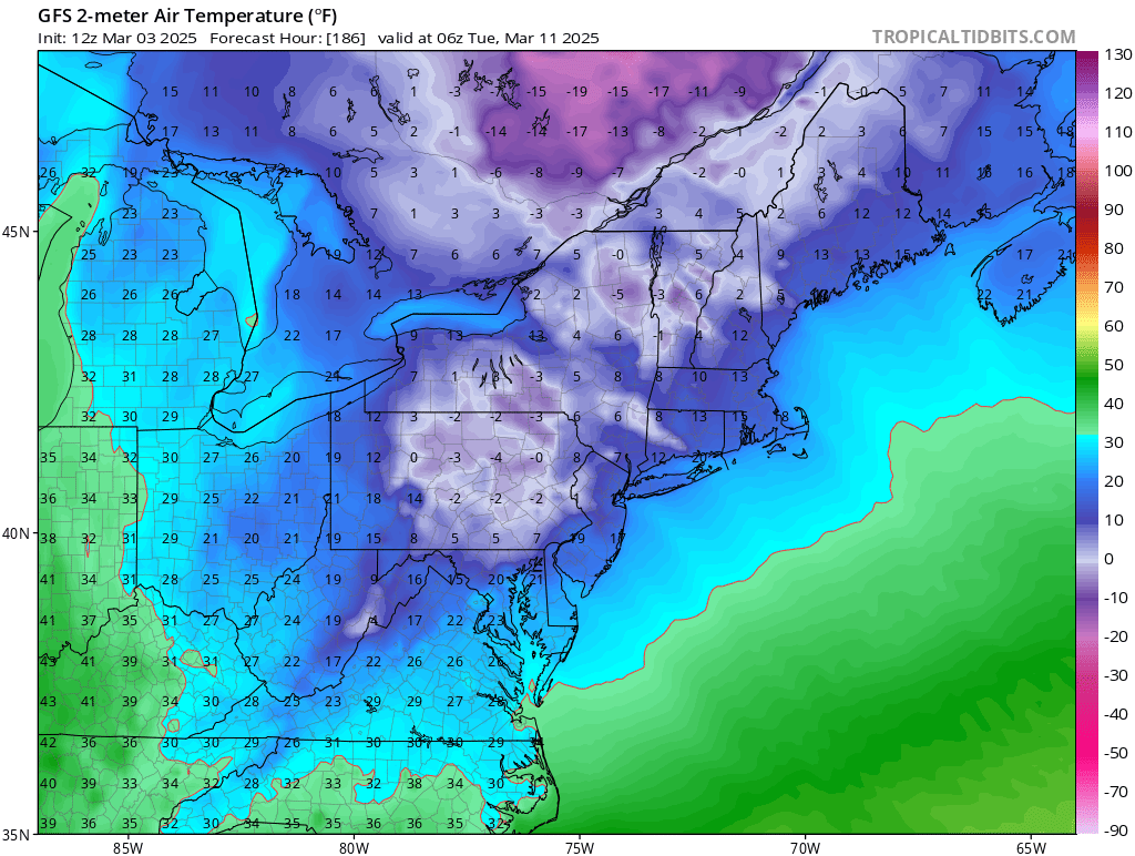
I will one up you and say wind advisory criteria will be met with a brief shower as the LP moves away . Personally this is graupel type of storm event as unstable cold air advects. I tell you what really made me LOL almost made me piss my pants was the aftermath of this BS storm event with the temps as seen below. When is the last time we saw -4 temps in middle march?

-
THis is what I think of this model run. https://www.gettyimages.com/detail/video/president-george-w-bush-delivers-his-famous-fool-me-once-news-footage/1271658781
-
New years eve all over again on Wednesday evening folks That is the last time we had t storms and significant rains. 1-3 inches of rain will be a billion dollar rain event for farmers and landscapers in eastern PA and will definitely help this years crops and finally reestablished green lawns again. However, this rainfall event will only put a dent in the long term drought but it will be a significant dent in getting water back into the ground. The combination of warmer temps of 50 degrees on Tuesday into the weekend with the heavy rain will thaw out the entire frozen soil profile quickly. With no extreme overnight cold temps like over the past weekend, the greener lawns and budding of trees, daffodils and other bulbs popping up will be noticeable by the end of the weekend. Their is also a real good chance of a squall line with severe t- storms, straight line winds and a severe t- storm tornado watch being issued. Best potential weather event all winter. But after this event, it is back to the SOS again with wind and dry temps. At least the fire danger will be gone. Once the cold front tracks through the area late Wednesday night, precipitation will diminish as drier air begins to move in from the west. In terms of rainfall amounts, expecting between 0.5-1.0 inches across the Coastal Plain. Across the higher terrain of northeast PA and NJ, including the Lehigh Valley, rainfall amounts between 1-2 inches are expected. Localized higher amounts could be possible.
-
LP not deep enuf Give me a 970 LP
-
why not we got nothing to lose at this point. Love to see the secondary LP form at the BM and smack us with a anafront MIller B storm event of 4-6+ inch of wetsnow if it would stall out. Just wishful thinking.