

Albedoman
-
Posts
1,379 -
Joined
-
Last visited
Content Type
Profiles
Blogs
Forums
American Weather
Media Demo
Store
Gallery
Everything posted by Albedoman
-

-
Many of us have been burned with digesting the LR models now as gospel the last 30 days. Even the SR models have been questionable as the parade of overrunning events over extremely dry air masses and the the basic geography of the Blue Mts are destroying any chances of a nice snowstorm event in Eastern PA. To even see a 3-5 inch event for Saturday is IMHO questionable the air as the conditions must be absolutely perfect for this to happen in this crappy pattern. I still have doubt on a 1-2 inch rain this weekend. most likely .50 to 1 ".
-
Keep the dry air coming baby. Less than .25 in of any type of precip is great for assuring my drought emergency. LMAO MY new motto- Sublimation rules!!!! LOL. Pure ass sleet right now. Another waste of cold air for snow production. The dry air just will not retreat. The poor people who spread salt will have wasted their money in the morning as it turns to plain light rain/drizzle . Predicted high of 52 degrees with rain on Sunday- break out the shorts. Then Monday we go back into the freezer awaiting another batch of wasted arctic dry cold air with no storms. The LR modeling is so undependable right now in this progressive flow pattern. Just about every 10 day run in the last 20-30 days have shown 16 in + of snow for the LV and what do we have to show for all of these wonderful and trustworthy model runs about 3 in of snow and garbage. By Sunday all ice and snow on the ground it will be just a distant memory. Sunday, we actually might get more than .50 in of rain but I am not holding my breath that's for sure. Again no drought buster as the ground is still frozen and it the runoff even on Sunday will all runoff anyway.
-
 the drought lives on baby Every model run and radar is getting drier and drier. I will not be satisfied until a drought emergency is issued by PADEP LMAO. By the way, I warned you guys about the abundance of sinkholes in our general area for the past 3-4 months. I-80 fell into a massive on yesterday and it is getting bigger. This is the late 60's all over again. We need a a 93 superstorm badly. Maybe the first week in March will produce something major and pattern changing because the models tell me jack shite on even getting a WSW event for us for the next two weeks after continuously showing 30+ in of snow for the LV in the past three weeks . Just give at least 3 2" rain events now to hell with the snow. I did not even use the snow shovel for the sleet event, it sublimated away. LOL. https://abc7ny.com/post/north-jersey-traffic-80-wharton-faces-emergency-closure-sinkhole-appears-return/15888495/
 -
I have seen this type of scenario pan out before many times in the last 30 years. The second low essentially becomes a modified but weaker miller B type of storm event as it digs in later and goes rapidly to the northeast as the dying transfer low holds on little longer east of the Apps instead of completely dying in western PA. The key is how long does it take the secondary low to form with bringing a decent wave through central PA . A million dollar question in this progressive pattern. If the wave did happen this way then a winter storm warning upgrade could be needed later Wednesday in the middle of the snow event.
-
this a good map as the screaming progressive winds die off a little. Lets hope it holds
-
fwiw, I posted this earlier. Yes I am disgusted with the models the last few months. It will literally take a miracle of a storm event to get out of this very progressive pattern with no ties to GOA or Atlantic moisture to build upon for our area with storm events. The drought is the king folks for the foreseeable future. I will no longer rely on the models for precip prediction until the progressive pattern changes for weeks rather than for one event. Every model has been horribly operating with wild swings in precip amounts on EVERY SINGLE model run the past two weeks. This happens in a progressive pattern when a single storm event is able to tie into a moisture source like the GOA or the Atlantic. Another fine example of what I am talking about - where the f&*k is the sun today? It was supposed to be mostly sunny not 95% cloudy for 100th time this past six months. The SR models need to be calibrated PERIOD in these progressive patterns and I have been at this game for over 40 years. The air is to damn dry and flowing across the country at break necking speeds. Hard to forecast in these pattern conditions - not faulting MT Holly forecasters as they do a great job analyzing these models but relying on modeling tools appears to be not working even for cloud prediction thats for sure. The accuracy of the current modeling is going backwards not forwards for LR modeling too. Throwing different models out there is not helping either like the Icon Ukie JMA etc. NOAA needs to add additional data sources in the Pacific Ocean and sparse areas to increase the reliability of the data for LR modeling.
-
It will literally take a miracle of a storm event to get out of this very progressive pattern with no ties to GOA or Atlantic moisture to build upon for our area with storm events. The drought is the king folks for the foreseeable future. I will no longer rely on the models for precip prediction until the progressive pattern changes for weeks rather than for one event. Every model has been horribly operating with wild swings in precip amounts on EVERY SINGLE model run the past two weeks. This happens in a progressive pattern when a single storm event is able to tie into a moisture source like the GOA or the Atlantic. Another fine example of what I am talking about - where the f&*k is the sun today? It was supposed to be mostly sunny not 95% cloudy for 100th time this past six months. The SR models need to be calibrated PERIOD in these progressive patterns and I have been at this game for over 40 years. The air is to damn dry and flowing across the country at break necking speeds. Hard to forecast in these pattern conditions - not faulting MT Holly forecasters as they do a great job analyzing these models but relying on modeling tools appears to be not working even for cloud prediction thats for sure. The accuracy of the current modeling is going backwards not forwards for LR modeling too. Throwing different models out there is not helping either like the Icon Ukie JMA etc. NOAA needs to add additional data sources in the Pacific Ocean and sparse areas to increase the reliability of the data for LR modeling.
-
Mt Holly is leaning on the outcome of Tuesday's storm in this morning's discussion- it is no drought buster. No warning criteria for the LV thats for sure with only a couple of inches in the forecast. .A far cry from the 12 + inches in last weeks model runs. The hype by the media will be cured IMHO. It will literally take a miracle of a storm event to get out of this east west progressive pattern with no ties to GOA or Atlantic moisture to build upon for our area. I-95's enjoy your 4-6 inches because it will all be gone with Fridays rain event.
-
actually Ralph, I feel the same way. when the LR models show 40 in snows for 4 to 5 days in a row than nothing- its time for the forum to stop looking at them. GFS and the European could NOT sniff out a pile of dog shit right now at ten days. This progressive pattern with no SE troughs is killing us. Tonights storm was a disaster for the meso's. We need a March superstorm like 93 to break up this shitty drought pattern we are in. This drought is no longer a laughing matter as sinkholes are opening up everywhere in the LV the last two weeks There is absolutely ZERO spring groundwater recharge anywhere south of the Poconos with no snowpack on the ground. The base flows of the stream in the limestone geology are falling rapidly. I guess all we can do is hope the one of the storms dumps some snow on us. The Friday storm that Mt Holly is calling for rain- I bet it does not even rain .50 in. All of that will also run into streams as the ground will still remain frozen. The next winter storm warning will only be issued during the storm event because MT Holly cannot even trust getting 6 in totals in the models before the event LOL
-
How dry is it? The Little Lehigh is a spring fed limestone stream. When we had the -15 degrees temps a few weeks ago, ice formed on the banks of the 55 degree water. Since then, the banks of the stream have remain frozen but the baseflow has continued to drop. The ice hangs over the streams edge by up to a foot above where the original base flow was flowing. I have never seen the base flow of this stream this low in the winter in 30+ years. The sleet tonight will not help much, just make it worse as it freezes the surfaces of the ground and only causes an immediate runoff into the streams from any salted roads without recharging groundwater tables plus its the amount of moisture content is nothing. Its like raining ice cubes on frozen surfaces. The only real melting is from man made salt application or sublimation tomorrow morning when the sun peaks out. At this point, Like what Mike Gorse stated ,I will take 2-3 inch rainstorm over this crap anyday. The dry air preceding every storm since New Years day here has been as so abundant. Its like to get it to snow in Las Vegas for every winter storm event. The models literally cannot handle this scenario on the east coast and they are going wacko with timings of the storm event to total precip amounts. The amount of virga and the progressiveness of the precip is way too fast. The models just cannot see this scenario very well. Its back to old days of waiting for just the right time to get a heavy snow event. Its just not in the cards right now.
-
Wel another forecast down the crapper. Solid sleet. No snow here in macungie. Just like i said earler, the late start has destroyed the snow forecast. Get ready for a possible ice storm update and thundersleet
-
wise decision. The old farts like me always wait until 48-72 hours when the pac buoys are no longer calling the shots for the models for accurate precip totals . That time period starts at the 0Z models tonight. Consistency is what I am looking for, not for actual amounts this far out. 12-18+ has been demonstrated in the models but not proven yet. The more accurate data ingestion in the models the better consistency. Tonights storm is a literal crap shoot. The damn moisture again is being sucked out of the atmosphere before the LP hits our area. I got down to 15 degrees this morningt and my indoor humidifier is running like gang busters again. The only saving grace maybe an upper level low forming in the sw of the Altoona area that may swing buy and give us some thundersleet/snow. That is worth seeing. Also, dendritic growth could be an issue early this evening with half dollar to pancake size flakes forming and can pile up quickly. The snow accumulations are all over the place indicating 2-7 inches tonight on the mesos. I am sticking with the HRRR as it has been somewhat believable in the last few storms for the LV. 3-5 inches of snow appears to be a good bet right now for me but nothing surprises me and the later the start, the less we get as the upper level low will be getting its shiot together further northeast of us and we get screwed again. By the way, my prediction the wording "my roads are caving" will be used a lot in posts later this evening LOL
-
I would not even think about Tuesday snow amount until we see the Pac data gets ingested on the Sunday OZ runs. Thats how it works Bets are out now and 6+ inches looks like a decent bet right now. The models have been consistent for at least that amount thus far. Whats nice right now that no one has commented on is that the OZ NAM has showed 3 in snow for positive snow depth in our area. Would not be surprised if the cold air holds on longer to see lollipops of 5-6 inches Sunday morning. The dense fog too tonightis really helping as the cold air advection comes in more slowly this time with more moisture available near the surface.
-
Nope, I admit I was wrong, came up short only about an 1.10 in of snow sleet and freezing rain. Underperformer for sure. Too much dry air plain and simple. The virga on the radar was unbelievable as the lower layers were really dry. Saturday night hopefully will be different. The atmosphere will be more juiced up from this storm event and Sat nights will hopefully juice it up for Monday nights storm event. For the first time in over a week today, my portable house humidifier stopped running for more than 4 hours. Thats a good sign to me that a change is coming. By the way, a dense fog warning has been issued. Now thats a great sign for Sat nights storm event that there will be more than a couple inches of snow with the higher moisture content in the and no extreme cold air in place.
-
I will take a seasons worth of snow right now in Macungie just to break this fricking drought. Oops, the 18z tonight says I will grant your wish of 40 inches snow in the next two weeks. Give me a break. There is no way in hell I believe that clown map and we have come up short the last three winter storms on even a.25 in of precip. These clown maps should be really called "WET DREAM " maps LMAO.
-
First and most likely my last call for tomorrow night for Macungie - 2-4+ inches of snow and sleet and then a prolong period of light freezing rain and drizzle to form a nice crust. Real bitch to shovel and to drive. Warning, do not scrape off snow/sleet until event is over on the vehicles and walkways. Put down salt tomorrow afternoon. You want the brine on the bottom of this crap By next weekend, we will get crushed. 12-18+ inches for the LV looks promising. with the better model consistency coming into play.
-
Yes this my thought as well. 3 to 6 rather than 2 to 4 on the snow amount o
-
and who will never forget this icing event involving I-78 in 2007. OMG was that bad . I live near I-78 and I will never forget that night https://www.pennlive.com/life/2020/02/marathon-storm-dumped-snow-ice-and-freezing-rain-on-valentines-day-in-2007.html
-
well how am I doing? LOL 20+ inches by Valentines on GFS
-
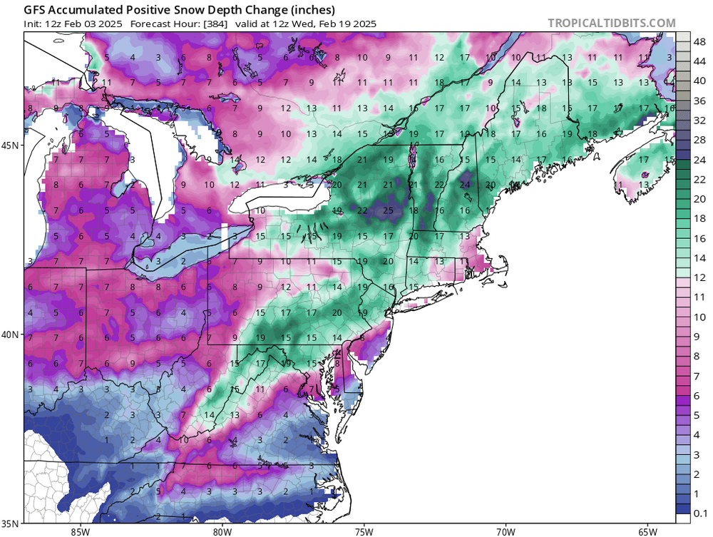
When I see that this much snow being shown on the positive snow depth change map , Its time to get rested for some serious snow shoveling
-
Almost an inch now in macunhie. Moderate snow. Everything covered. By noon tomorrow it may be all gone
-
You are hearing this prediction from me first- mark it down. The potential for major ice jams along the Delaware, Lehigh Schuylkill ,Susquehanna riverine systems with major flooding will be in the media real soon. Once we get a week of 45+ highs in these areas with some major rains of 2-4 inches places, like Trenton, just north of Belvidere/ Portland areas on the Delaware, Kline and Adams Island on the Lehigh are going to be the hotspots for flood damage. I have seen before, we will see this time too.
-
down to 5 degrees at 10:45. heading for another night below zero
-
First and last call 2-4 inches for the LV if we are really lucky with the snow ratios. Just enough to get the ground white. Time to put this storm to rest for the LV. No drought buster for sure. From Philly west to Harrisburg 6-8 in is a good bet --Warning level for them- advisory for the LV. This storm is a Ohio Valley special. From Indianapolis to Columbus to Washington, they get buried. They deserve it as they have been snow starved for years too. Our turn will becoming around Martin Luther King Day. Cold and dry will become the norm like the December 20th-25th time period. January 3 The upcoming pattern change on the 10-12th reverts back to the SOS. This drought is really going to be bad come January. The low flows in the limestone geology streams is beginning to freeze up the normally warm spring fed streams for the lack of a good flowing base flow. The trout population is literally being destroyed. I can only imagine how low the ground water table will be in February and how wells will dry up in the middle of winter. Even with a major snow event and with the ground frozen, no recharging of the groundwater table will take place for months. The latest moderate rains... December 5, 2024 I have been harping on the Enso going neutral and about how this winter could be like bitter cold and dry like 94, which I was right. The next biggie-- a major snow event in and around Valentines day in this current pattern regime. I am not really concern at this time about the potential for a significant ice storm for next week as the saving grace is that the moisture is not around to produce .5 to 1" ice accumulations.


