Albedoman
-
Posts
1,380 -
Joined
-
Last visited
Content Type
Profiles
Blogs
Forums
American Weather
Media Demo
Store
Gallery
Everything posted by Albedoman
-

1/6 snowstorm - nuisance event or something bigger?
Albedoman replied to LVblizzard's topic in Philadelphia Region
Yes, 12 hours ago. Gfs forget it -
1/6 snowstorm - nuisance event or something bigger?
Albedoman replied to LVblizzard's topic in Philadelphia Region
First and last call 2-4 inches for the LV if we are really lucky with the snow ratios. Just enough to get the ground white. Time to put this storm to rest for the LV. No drought buster for sure. From Philly west to Harrisburg 6-8 in is a good bet --Warning level for them- advisory for the LV. This storm is a Ohio Valley special. From Indianapolis to Columbus to Washington, they get buried. They deserve it as they have been snow starved for years too. Our turn will becoming around Martin Luther King Day. Cold and dry will become the norm like the December 20th-25th time period. -
1/6 snowstorm - nuisance event or something bigger?
Albedoman replied to LVblizzard's topic in Philadelphia Region
I will repeat for the naysayers below. Analyze all you want. Tonights 's 0z runs will be exciting for most of you. Has been a few years waiting. The NAM will be the usual suspect. The northward trend at the end of the run is very promising for the philly area. Posted 12 hours ago I have repeatly posted the last 3-5 days, plz wait until the 0z runs tonight. Thats where the W PAC data gets really ingested into the models for the first time. Anyone analyzing every 4-6 hour model run will work themselves into an utter panic attack. This is from 30+ years of modelology experience. Tomorrow nights 0z runs should be quite exciting after this clipper swings by and leaves a trail of bread crumbs to follow for the next snow event. Thats where the true path should come to fruition for next weeks storm. -
I have repeatly posted the last 3-5 days, plz wait until the 0z runs tonight. Thats where the W PAC data gets really ingested into the models for the first time. Anyone analyzing every 4-6 hour model run will work themselves into an utter panic attack. This is from 30+ years of modelology experience. Tomorrow nights 0z runs should be quite exciting after this clipper swings by and leaves a trail of bread crumbs to follow for the next snow event. Thats where the true path should come to fruition for next weeks storm.
-
Firts of all, as I stated yesterday, tomorrow nights Oz run will tell us what we will get. The Pac buoy data will be ingested and will show us how much moisture streams NE. Right now it looks like zippo- just like the other crap we have had in December- cross your fingers that the ealier Euro runs hold 3-5 days ago. Noy good for ending the drought thats for sure Yes Red Sky is spot on- time if the sky clears out, Aurora time. You all should check this site veryday. Flares do affect us https://spaceweather.com/
-
nice t storms tonight. This was even better than a 2-4 inch snow event. Times a changing now.
-
I am sticking to 3-5 days out analysis when the W Pac buoy data gets ingested into the models. No sense even lookig at the LR models now until Jan 2. Now is the time when the Euro and GFS will lose the storms or they get squashed by supression or some other model performance stunt as this is beginnning of a really major upcoming pattern change The 0z run on Thursday morning might show what will really happen going into this new pattern. Anything on the models now is just where the pattern is leaning. The cold temps after this pattern gets set in is what concerns me. I see a huge CAD event aiming for us toward the 20th time frame in our area as these LP's are finally to form along the SE Texas coast as stated in an earlier post with the deep cold and a potential deep snow pack in place. I do not like ice storms like 94. Salt shortages may become an issue again by mid February if this cold pattern stays put This potential salt situation reminds me of the TP hoarding syndrome in 2020 with COVID. A lot of salt will be needed with the cold temps in place unlike previous years. Many municipalities will be ordering more salt which will become problematic as these same municiplaities will be ordering the salt at the same time. Be prepared for long lines at the car washes on sunnier warmer days and salt being gone at places like home depot. This situation with the deep cold/snow pack is exactly what I stated several months ago that would occur when I said the La Nina was weakening going into a neutral pattern. Many posters disagreed. I go by past weather history patterns and events , not just modelology. All it takes is a major pattern change and that is coming next week. The drought conditions are finally but slowly starting to relax now has ralso eally demonstrated this weakening LA Nina pattern too as this new pattern neutrality will eventually break the current drought by the end of Feburary.
-
The 3-5 trusted w pac buoy data has not even been ingested at 10 days. I will not take until five days from the event I have been burned plenty of times.
-
Hey guys, look at this evenings 18Z GFS run. Looks like Dallas to Memphis gets some snow in week or so and oh wait 6 in + for us too. Now where did I hear that scenario before? LOL I love the memphis discussion below for tonight. It is a dream forecast for me to hear booming t- storms at Christmas Hell , we could not even squeeze out one decent t- storm here all last summer with any booming thunder and they get it in the winter. What slap in the face for us. .DISCUSSION... (This evening through next Wednesday) Issued at 205 PM CST Thu Dec 26 2024 Shortwave ridging across the region has allowed mostly dry conditions across the area today. These dry conditions will be short lived as a low pressure system will return showers and thunderstorms later this evening. Depicted on deterministic soundings, a steep inversion will be over the Mid-South this evening. This inversion will keep the gusty winds from mixing to the surface as well as limit surface based instability. A maritime tropical airmass has struggled to move over the region with this inversion as dewpoint depressions are still around 10 degrees or more at this hour. The severe weather threat tonight is very marginal at best. The thunder, however, will be intensified due to the inversion, so prepare for loud thunder to awake you overnight. While the severe threat is limited, heavy rain is still a concern. Precipitable water (PW) values will be in the 90th percentile (around 1.3") for this time of year. Highest rainfall totals will be along and west of the Mississippi River hovering around 2".
-
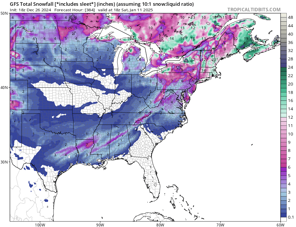
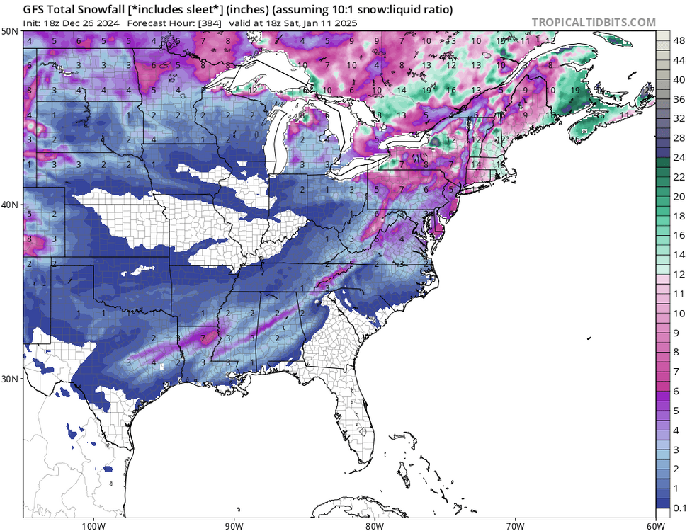
MIller A potentials setting up by mid January. For the first time in 5+ years, I see GOM lows forming off the SE Texas coast in the LR modeling. The 4 corner lows are dipping down into Mexico , going west into the GOM and sucking up the moisture from the GOM, then heading NE. Hope this pattern keeps up. Rule of thumb for the newbies- If it snows in Memphis/Dallas, we usually get 6+ in of snow here. With the lows forming and deepening in Southern MS, we stand a good chance of seeing this scenrio unfold. Lets hope that the CAD situation like 94 does not come a problem if a portion of the Vortex breaks off and hits first. I would love to see a +PNA and at the same time the GOM lows start producing, then the potential for major snow events increases exponentially. Yes, this morning is a local traffic nighmare. The salters came by, did not even melt the residential roads. Hopefully when the sun comes out in a few hours, things will change. Red Sky, I am glad you got your white christmas. Never give up. I went over the Green Lane reservoir yesterday, I was sick to see how far it is down right now. The drought lives on. What water remains is frozen, thus no runoff storage possible from any rains after Christmas. The soil is like concrete right now. We really need a 3 inch rain with 50 degree temps after the New Year before the next major snow event.
-
I will be the first to say that if you are traveling Tuesday morning anywhere in the LV, please wait. Mt Holly has stated no advisories will be necessary issued as it does not meet the criteria( LOL) but they will be criticized come Tuesday morning as a potential 1-2 in snowfall will be a traveling disaster. Why? The roads will be so cold that any snow that falls will imediatley stick. A simple one inch snow on frozen road surfaces where salt will not work is way worse than a 3-4 in snow on warm roads with brine/salt like this past event. Brine will not work and placing salt down will not work. Drivers are also not used to driving on coated and extemely cold road surfaces and accidents will be everywhere. I urge Mt Holly to rethink this situation. A MIllion people now live in the LV where the freight capital of the US exists with the thousands of trucks running through the area. Salt does not work below 20 degrees on road surfaces. Its been over four days of temps below 32 degrees and with temps below 20 degrees for 2-3 days. Todays high will be in the low to mid 20's and the overnight lows tonight will be in the upper teens. After becoming cloudy by this afternnon, no chance of the road temps going up. You make your own choice but for me, I am staying off the roads until the sun comes out on Tuesday afternoon. These are the silly games of meeting criteria for advisories that NOAA needs to wake up on. Temps do matter regardless of the amount of snowfall. Case closed.
-
well Red Sky, you will have your white Christmas like I had promised. The big snow event was last night and not on Christmas eve/day . As I said my earlier posts days ago, if their was a decent snow pack, we would have below zero overnight lows. Well Monday morning wil be a dandy with temp below zero at my house and for many in the LV. I expect a 1-2 inch refresh of the snow pack on Christmas Eve and then it is off to big time moderation with lots of rain maybe an ice storm. This MAJOR pattern change coming up may lead to some decent snow events in mid january
-
3-4 inches in Macungie right now. still snowing
-
2 to 3 in on deck still puking snow
-
bullseye for me but this does not make sense . A norlun trough does not set up like this but I will take the outcome
-
I will take anything at this point. A 1-3 inch snow event would be a huge win in this crappy season thus far and overnight raditional cooling with a snow cover on Sat morning would push the lows in the single digits for sure over the weekend.
-
Well it now appears Christmas day will be brown. NO major snow event anywhere on the models for our area for and after Christmas and in fact after Christmas we get torched. Rain I will take but this crap of having freeze your balls off temps with no snow pack is utterly ridiculous. So many years of this stupid weather pattern is got to end soon. The snow producing storm events never matches up with the deep cold anymore as the deep cold air sticks around only for a few days . We are always on the frozen/liqid precip line too as a result. If we would have had a decent snowpack this weekend, we would have been below zero for overnight lows. I aslo do not know which is worse, the snow drought or rain drought? LOL I am sorry but with my 50+ years of weather history experience, I am realizing that the only way to break this shitty snow producing weather pattern will be a severe ice storm with a real deep and strong cold snap from repeated passing clippers every 2-3 days- kinda like 94. LOL.
-
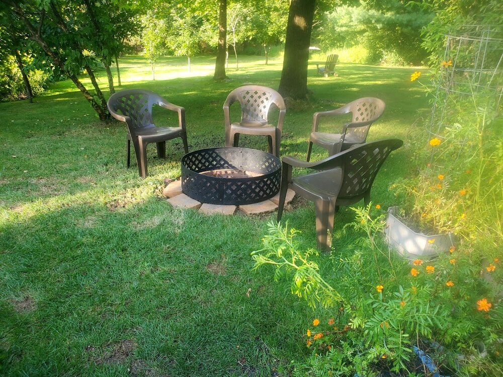
dusting on the deck now- give me a break- no drought buster. The burn ban is lifted now in Lehigh county. Time for a fire with my new fire ring on Tuesday evening. Been waiting a long time almost 3 months. 55 degree high and sunny on Tuesday afternoon. Time to burn the fallen limbs. Last true day of fall before "WINTER IS COMING"
-
too much missing buoy data in the west PAC. Drones on the NJ coast hogging it all LMAO
-
MIne was right at 2" Flurries at the end more today. ...Lehigh County... 1 NE Lynn Twp 2.55 in 1005 PM 12/11 AWS Germansville 2.04 in 1010 PM 12/11 CWOP Slatington 2.03 in 1007 PM 12/11 CWOP New Tripoli 1.97 in 1000 PM 12/11 CWOP Center Valley 1.94 in 1008 PM 12/11 CWOP NEW TRIPOLI 1.91 in 1009 PM 12/11 CWOP Slatington 1.86 in 0930 PM 12/11 HADS Trexler 1.84 in 0943 PM 12/11 RAWS Fogelsville 1.81 in 1000 PM 12/11 CWOP
-
MY update: No drought buster. However it is the heaviest rain since early August for my house in a 24 hour period. Nearly 1.80 inches in the gauge and still raining. Underground weather precip reports mostly range from. 1.5 to 2 inches of rain in Lehigh County with more north near Tamaqua. Its nice to see the Little Lehigh at bankfull for a change. No stream flooding as the ground is taking it all in nicely. I expect this to be all out of here by midnight. There will some big wet snow flakes at the very end of the precip with maybe a coating on the cars. I expect this to happen between 10 pm and midnight Temps are dropping pretty good now high 64 this morning. Now it is 45 and falling Still fishing for a white Christmas - not goiving up just yet
- 1,105 replies
-
- 3
-

-

-
- tropics
- heavy rainfall
- (and 5 more)
-
white christmas on the 18Z hope is still alive
-
its going to be close thats for sure. This needs to be watched, maybe the 26th. Anyway, much needed rain by wed- thursday 2-3 in of rain by the latest runs with the possibility of anafront snowfall of 1-3 inches changeover as the really cold air quickly advects in behind the cold front. This would be nice because the snow that sticks to the ground after the rain will not melt for days. This situation will really help with soil moisture before the ground freezes shut by next weekend.
- 1,105 replies
-
- 1
-

-
- tropics
- heavy rainfall
- (and 5 more)
-
call it whatever the hell you want for the ENSO, but if we do not get substantial rains in the next 3-4 weeks we are in some deep shite. When I say susbsantial, I mean 3-6 inches spread out in a course of 2-3 weeks. The ground is frozen now in some places, Pure runoff does not help as the only benefit would be to hold off the salt water intrusion into the Delaware a few weeks longer. We need the ground to warm up, which we will get in the next few days but the 12th storm event is an absolute joke as a precip maker right now in the models. Sorry but .5 in rains for a few days will not cut it for some droughgt relief unless we became Seattle again, which I do not see with this progressive upper air flow at all My Christmas storm is slowly going away to the dumpster fire after every model run. WE cannot even squeeze out a good rainmaker of a noreaster. All I can say is that we are not the only ones being screwed in this crappy weather pattern. The Midwest, specially north of the Mason Dixon line is way too warm and dry. Without a good snowpack there, were are really screwed here. Any clipper that reaches here will be DOA without moisture. Flurries and snow shower will not cut it. The winners for snow- Great Lakes. Just when their feet of snow melts next week, they get another round. Will the lakes ever freeze up again in my lifetime LMAO? That pece of siberian high that has remained in Russa for the last 3 years needs to get its ass parked right over southern Cannada for 15 days.
- 1,105 replies
-
- 1
-
-
- tropics
- heavy rainfall
- (and 5 more)
-
This drought is rapidly becoming pretty damn serious folks Water supply managers for the Delaware River Basin this week declared an “emergency,” setting the stage for further action if dry conditions persist. The Delaware River Basin Commission declared the “water supply emergency” during its quarterly meeting Thursday. The declaration along with two special permits that were also approved allow the commission to coordinate operations of regional reservoirs, diversion from outside the 42-county basin area and Delaware River flow objectives. The last time commission officials declared such an emergency was in 2016, spokeswoman Elizabeth Brown told lehighvalleylive.com. “We’re essentially getting the table set if conditions continue to deteriorate,” she said. Despite recent precipitation, the potential is still there to reach basin-wide drought operating conditions that would trigger the action authorized Thursday. All but two of the counties in the basin covering communities in Delaware, New Jersey, New York and Pennsylvania are under drought watches or warnings declared independently of Thursday’s approvals. Those two counties are Lackawanna and Wayne in Pennsylvania. “DRBC urges all water users to fully cooperate with Basin state water use restrictions and conservation measures and encourages all Basin water users to maximize water efficiency wherever possible,” the commission said in a news release following Thursday’s approvals. A basin-wide drought declaration would occur if available water storage drops below a certain level in three New York City reservoirs — Cannonsville, Pepacton and Neversink — located in the Delaware River’s headwaters in New York. As of Thursday morning, storage was 25.9 billion gallons above a drought watch. “Over 14 million people rely on the shared waters of the Delaware River Basin,” Executive Director Kristen Bowman Kavanagh states in the release. “During times of drought, the DRBC’s primary responsibility is to conserve and protect water supplies.” The commission is responsible for protecting water supply throughout the Delaware River Basin, including by managing the flow of the Delaware River to repel the salt front of the Delaware River Estuary to avoid fouling drinking water supplies for Philadelphia and millions of other people. “The special permits approved today will set in motion management actions that will maintain access to clean water for the entire Basin, should conditions worsen,” stated New York State Department of Environmental Conservation Interim Commissioner Sean Mahar. Thursday’s approvals would, in part, reduce Delaware River flow objectives at Montague, New Jersey (supported by releases from the New York City Delaware River Basin reservoirs) and at Trenton (supported by releases from the Beltzville and Blue Marsh reservoirs in eastern Pennsylvania). That’s if the dry conditions continue. A separate special permit approved would add water releases from Lake Wallenpaupack and New York’s Mongaup system to assist in meeting the Delaware River flow objectives at Montague and Trenton. As of Thursday morning, the salt front was located at river mile 85.4, which is just south of the Philadelphia Airport. This is roughly 16.4 miles upstream of its normal location for this time of year, but still 24.6 miles downstream from key drinking water intakes.