Albedoman
-
Posts
1,380 -
Joined
-
Last visited
Content Type
Profiles
Blogs
Forums
American Weather
Media Demo
Store
Gallery
Everything posted by Albedoman
-

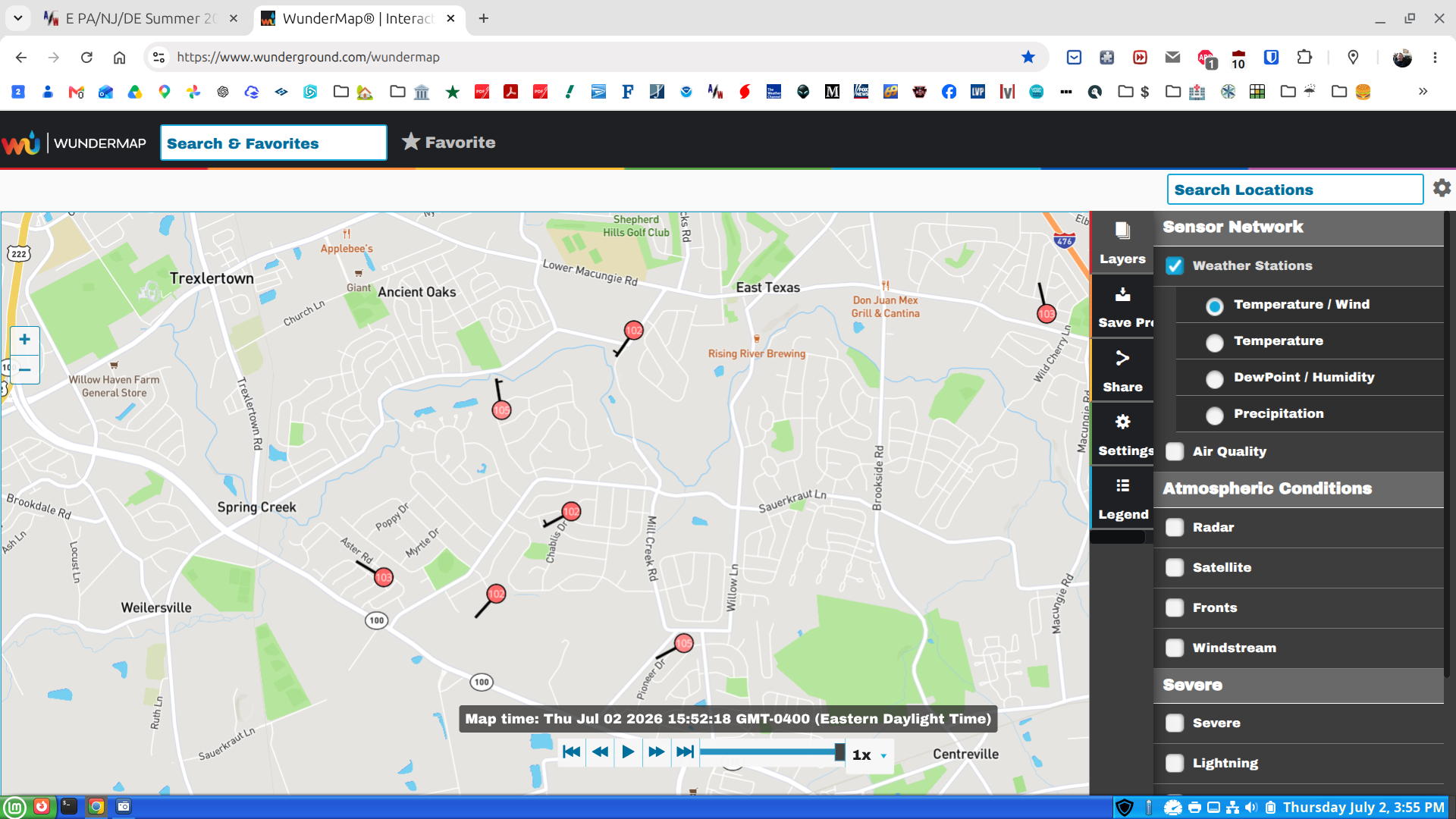
E PA/NJ/DE Summer 2026 Obs/Discussion
Albedoman replied to PhiEaglesfan712's topic in Philadelphia Region
Swing and a miss again . Here comes the drought emergency -
E PA/NJ/DE Summer 2026 Obs/Discussion
Albedoman replied to PhiEaglesfan712's topic in Philadelphia Region
this is what I mean by the winds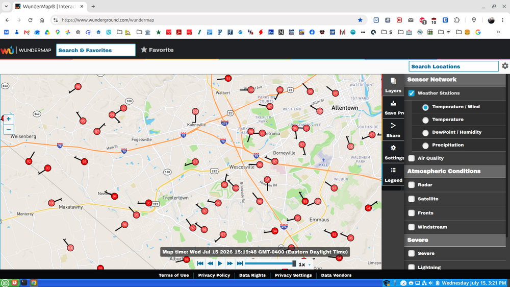
-
E PA/NJ/DE Summer 2026 Obs/Discussion
Albedoman replied to PhiEaglesfan712's topic in Philadelphia Region
Unfortunately, the Lehigh Valley will likely be even hotter today. The stiff, breezy westerly winds bringing wildfire smoke into the region are also acting much like a Santa Ana wind as they descend the Blue Mountains, warming and drying the air. Humidity is very low, and it's already 95°F at noon. I wouldn't be surprised if Allentown and Reading reach 100°F or higher this afternoon, while the Philadelphia area may stay a few degrees cooler because it won't benefit from the same downslope warming effect. -
E PA/NJ/DE Summer 2026 Obs/Discussion
Albedoman replied to PhiEaglesfan712's topic in Philadelphia Region
Total whiff for the lv tonight. Whatever padep or usgs comes up with for drought maps this week, they mean zilch. Let the real drought reports begin. -
E PA/NJ/DE Summer 2026 Obs/Discussion
Albedoman replied to PhiEaglesfan712's topic in Philadelphia Region
Last chance for a t storm following the ne turnpike. It all or nothing for the LV in the next few hours. -
E PA/NJ/DE Summer 2026 Obs/Discussion
Albedoman replied to PhiEaglesfan712's topic in Philadelphia Region
LV swing and a miss strike 3 we are out of t storm chances for today. The 7 10 split lives on. Just incredible outflow boundaries preventing us from getting decent rain. 50 miles on either side of the lv gets 2+ in of rain. This is no longer funny. Another week of no rain and temps near 100 , the little lehigh will go dry in spots. I really see a drought emergency issued by Lehigh County Authority by next weekend. The lawns will be burned if people mow them this week and corn will be spiking. -
E PA/NJ/DE Summer 2026 Obs/Discussion
Albedoman replied to PhiEaglesfan712's topic in Philadelphia Region
LV swing and a miss strike 3 we are out of t storm chances for today. The 7 10 split lives on. Just incredible outflow boundaries preventing us from getting decent rain. 50 miles on either side of the lv gets 2+ in of rain. -
E PA/NJ/DE Summer 2026 Obs/Discussion
Albedoman replied to PhiEaglesfan712's topic in Philadelphia Region
Same here. The lv got screwed again. The models cannot handle the dryness. The corn is smiling again. All we have gotten is the bad wind damage Ling -
E PA/NJ/DE Summer 2026 Obs/Discussion
Albedoman replied to PhiEaglesfan712's topic in Philadelphia Region
Thanks Ron. Have a laughlvulin on me -
E PA/NJ/DE Summer 2026 Obs/Discussion
Albedoman replied to PhiEaglesfan712's topic in Philadelphia Region
Absolutely. In fact that is where the dead ash tree in the streambed is a series problem. . The culverts were blocked a year ago and padot got in trouble by padep for cleaning out the Jordan creek too well. -
E PA/NJ/DE Summer 2026 Obs/Discussion
Albedoman replied to PhiEaglesfan712's topic in Philadelphia Region
This is what I was seeing last night as a potential for training t storms overe my area. I saw this similar setup in the 90,s. That's why I am concerned about down trees acting as debris dams in the flooded streambeds 5 + inches of rain will cause this to be a serious problem on major road bridges. Yes the rain is needed but not in 4 to 6 hours. Really. You should all drive around and look all the fallen dead trees in the streambeds now. It's horrific -
E PA/NJ/DE Summer 2026 Obs/Discussion
Albedoman replied to PhiEaglesfan712's topic in Philadelphia Region
While I only received about 0.75 inches of rain over the last two days, the winds have been quite impressive. With many areas still without power—from Lower Macungie all the way to Quakertown—I have no doubt that numerous fuses, transformers, and sections of the electrical distribution system have been damaged. I have been fortunate. Most of the electrical service in my neighborhood is underground, and the surrounding trees were extensively trimmed after Hurricane Sandy. That has undoubtedly made a difference. It raises an important question: Why aren't we making a greater commitment to underground utility infrastructure? Municipalities should be encouraged to require underground electric service wherever practical, while state and federal grant programs should help utilities such as PPL modernize aging infrastructure. Although the upfront costs are significant, the long-term benefits in reliability, public safety, and reduced storm damage are substantial. Many people also don't realize that restoring power isn't as simple as replacing a wire. Utility crews must first remove fallen trees, inspect miles of damaged circuits, replace transformers and fuses, repair broken poles and conductors, and verify that each section of the electrical system is safe before power can be restored. That process takes time, especially after a widespread wind event. What has made this year particularly challenging is the unprecedented number of dead ash trees killed by the emerald ash borer. As a township manager, I have been urging elected officials to dedicate funding for the safe removal of these hazardous trees, yet the response has largely been silence. These dead ash trees are creating the conditions for our next major disaster—not only through repeated damage to our electrical infrastructure, but also by increasing the likelihood of debris jams in our streams and rivers that can dramatically worsen flooding during future heavy rain events. A single blocked bridge opening or culvert can cause water to back up quickly, flooding roads, homes, and farmland even when rainfall amounts alone might not have produced significant flooding. The reality is that mitigation is almost always less expensive than disaster recovery. Every dollar invested in hazardous tree removal, stream maintenance, and more resilient utility infrastructure can save many times that amount in emergency response, prolonged power outages, property damage, and disaster recovery costs. Waiting until after the next major storm is simply the most expensive way to solve the problem. I am also surprised that there has been relatively little discussion tonight about the potential for our first widespread 3–5 inch rainfall event over the next three days. Forecasts can certainly change, but this is a weather system that deserves close attention. Perhaps many of us have become conditioned by the persistent drought of the past six months and tend to dismiss heavy rainfall forecasts. However, if this event unfolds as currently projected, localized flash flooding, stream flooding, and river flooding could become a very real concern—especially where fallen trees and debris restrict stream channels. Anyway, enjoy the cooler weather, and let's hope the forecast trends downward. But this is definitely one of those situations worth monitoring closely over the next several days. -
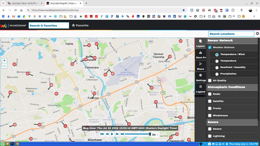
E PA/NJ/DE Summer 2026 Obs/Discussion
Albedoman replied to PhiEaglesfan712's topic in Philadelphia Region
https://www.mcall.com/2026/07/03/lehigh-valley-storm-damage-photos-july-3-2026/ -
E PA/NJ/DE Summer 2026 Obs/Discussion
Albedoman replied to PhiEaglesfan712's topic in Philadelphia Region
Yep my area was the hardest hit from the these storms this evening- from 102 temps down to the mid 70's comes with derecho type straightline winds like I said earlier this week could happen. Only .31 in of rain but the winds were bad. Spent an hour picking up dead limbs/branches in the yard and street. this happened less than 1 mile from the house---- Severe thunderstorms moved through the Lehigh Valley on Friday evening, temporarily dropping temperatures amid the extreme heat, but also causing significant tree damage that cut power to thousands of area residents just as Fourth of July celebrations get started. Some of the worst storm damage was reported in the Alburtis and Macungie areas, where numerous downed trees dotted the landscape. Alburtis declared a “state of emergency” due to the damage. “Please avoid unnecessary travel, stay clear of downed trees and power lines, and follow all guidance from emergency personnel,” according to a post on the borough’s Facebook page around 9:30 p.m. “Updates will be provided as crews continue assessment and restoration efforts.” One tree fell onto a house on West Fifth Street in the borough, tearing away part of the roof. A freight train was also stopped in the borough due to a large tree that fell on the tracks, blocking both railroad crossings on North Main Street and West Penn Avenue. As of 8 p.m., PPL’s outage map reported nearly 12,000 customers without power in Lehigh and Northampton counties. Areas reporting more than 1,000 outages included Washington Township, Upper Milford Township, South Whitehall Township and Lower Macungie Township in Lehigh County, as well as Northampton borough and -
E PA/NJ/DE Summer 2026 Obs/Discussion
Albedoman replied to PhiEaglesfan712's topic in Philadelphia Region
Just got hammered 60 mph wins. 35 in of rain. Nice rainbow. From 102 t0 92 in a few minutes -
E PA/NJ/DE Summer 2026 Obs/Discussion
Albedoman replied to PhiEaglesfan712's topic in Philadelphia Region
yes it is over 103 at my house with the winds now blowing from over the mountains heatint us up even more. Typical day in Southern Cal for me. I see a drought emergecy being delared for Lehigh county by the end of next week if we do get any t- storms after Saturday night. The corn is spiking and soybeans are now shriveling
-
E PA/NJ/DE Summer 2026 Obs/Discussion
Albedoman replied to PhiEaglesfan712's topic in Philadelphia Region
-
E PA/NJ/DE Summer 2026 Obs/Discussion
Albedoman replied to PhiEaglesfan712's topic in Philadelphia Region
-
E PA/NJ/DE Summer 2026 Obs/Discussion
Albedoman replied to PhiEaglesfan712's topic in Philadelphia Region
Over 100 at the house now. missed any rainfall to the ne of me -
E PA/NJ/DE Summer 2026 Obs/Discussion
Albedoman replied to PhiEaglesfan712's topic in Philadelphia Region
Over 100 at the house now. missed any rainfall to the ne of me -
E PA/NJ/DE Summer 2026 Obs/Discussion
Albedoman replied to PhiEaglesfan712's topic in Philadelphia Region
The formation of Derechoes are a good possibility in this pattern. -
E PA/NJ/DE Summer 2026 Obs/Discussion
Albedoman replied to PhiEaglesfan712's topic in Philadelphia Region
Huge 6 alarm fire in allentown -
E PA/NJ/DE Summer 2026 Obs/Discussion
Albedoman replied to PhiEaglesfan712's topic in Philadelphia Region
In lv near lower macungie , I had less than a.5 of rain. Western lehigh missed everything again. A drought emergency will be declared by weeks end -
E PA/NJ/DE Summer 2026 Obs/Discussion
Albedoman replied to PhiEaglesfan712's topic in Philadelphia Region
Today's conditions are exactly why common sense needs to prevail when it comes to open burning. Frankly, a Wind Advisory should have been issued. We have strong southwest winds crossing the Blue Mountain ridge, critically dry vegetation, and a growing rainfall deficit. These are the types of conditions that can turn a routine burn pile into a fast-moving brush fire in minutes. What concerns me even more is not the immediate fire danger, but what these continued dry conditions mean for the long-term health of our water resources. The drought situation is becoming increasingly serious, and too many people are focused on brown lawns instead of the bigger picture. The Little Lehigh Creek is one of the most important cold-water fisheries in Pennsylvania. Its exceptional wild trout habitat is sustained almost entirely by groundwater discharge. Unlike streams that respond quickly to rainfall, the Little Lehigh depends on a healthy aquifer system maintaining adequate base flows year-round. When groundwater levels decline, streamflows decline. When streamflows decline, water temperatures rise. When water temperatures rise, trout populations and the entire aquatic ecosystem suffer. The importance of the Little Lehigh extends far beyond the Lehigh Valley. Anglers, conservationists, and outdoor enthusiasts travel from across Pennsylvania and neighboring states to fish its waters. It is recognized as one of the premier limestone trout streams in the Commonwealth and serves as an indicator of the health of the region's groundwater resources. If base flows continue to decline, the repercussions extend well beyond trout. Reduced groundwater discharge affects wetlands, springs, private wells, agricultural operations, public water supplies, and the overall ecological health of the watershed. Once groundwater levels drop significantly, recovery is often measured in months—not days or weeks. What is often overlooked is the direct connection between the Little Lehigh, the regional aquifer system, and the Lehigh Valley economy. Numerous industries depend on abundant, reliable groundwater supplies. Companies and facilities associated with Nestlé Waters, Coca-Cola bottling operations, Pepsi distribution and beverage facilities, Ocean Spray suppliers, regional breweries, food processors, pharmaceutical manufacturers, and countless other businesses throughout the Lehigh Valley all depend upon the same groundwater resources that ultimately sustain streamflows in the Little Lehigh and surrounding watersheds. A prolonged drought does not simply affect trout streams. It can result in mandatory conservation measures, restrictions on water withdrawals, increased pumping costs, reduced groundwater recharge, higher treatment expenses, and operational challenges for water-dependent industries. When water supplies become stressed, the economic impacts ripple throughout the region through higher costs, reduced production capacity, and increased pressure on both public and private water systems. This is not simply a local issue. The Little Lehigh watershed plays a critical role in supporting downstream water resources throughout eastern Pennsylvania. Healthy base flows help maintain water quality, aquatic habitat, groundwater recharge, and ecological stability across the broader Lehigh River system. At the same time, dry conditions dramatically increase wildfire risk. The combination of low fuel moisture, gusty southwest winds, and abundant dry vegetation creates conditions where a single escaped burn pile can threaten woodlands, homes, farms, and emergency responders. The larger concern is that the Little Lehigh is essentially a window into the health of the region's aquifer system. When sustained reductions in base flow occur, it is often an indication that groundwater reserves are under increasing stress. That should concern every resident, every farmer, every business owner, and every municipality that relies on those same groundwater resources. The Little Lehigh is not important simply because it is a trout stream. It is important because it is one of the best indicators of groundwater conditions in eastern Pennsylvania. The trout are merely the first to tell us there is a problem. Long before municipal wells begin showing stress, long before industries face water restrictions, and long before consumers see increased costs, the Little Lehigh starts sending warning signals through declining base flows and rising water temperatures. If the Little Lehigh were ever to experience a significant and sustained reduction in groundwater-fed flows, it would be a warning sign for everyone—from homeowners with private wells, to farmers irrigating crops, to municipalities supplying drinking water, to major employers and manufacturers throughout the Lehigh Valley. Drought is not just an inconvenience. It is a public safety issue, an environmental issue, and an economic issue. Every day without meaningful rainfall places additional stress on our groundwater reserves, our streams, our industries, and the ecosystems that depend on them. Until significant precipitation returns and streamflows recover, extreme caution is warranted. The consequences of continued drought and unnecessary burning extend far beyond any one property—they affect the water resources, economy, and environmental health of the entire region. -
E PA/NJ/DE Summer 2026 Obs/Discussion
Albedoman replied to PhiEaglesfan712's topic in Philadelphia Region
I am on it. As I thought LCA is defietely worried about the base flow conditions of the Little Lehigh. We are down bigtime and near emergency status. The Little Lehigh and its watershed is the primary source of water for Lehigh County LCA-WeeklyReport-DroughtMonitoring-Dashboard-06152026.pdf