-
Posts
1,338 -
Joined
-
Last visited
Content Type
Profiles
Blogs
Forums
American Weather
Media Demo
Store
Gallery
Everything posted by Albedoman
-
Central PA Winter 2022/2023
Albedoman replied to Blizzard of 93's topic in Upstate New York/Pennsylvania
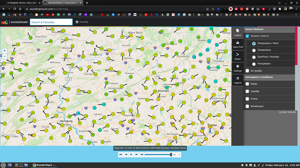
Please somebody tell MT Holly whats up with the temps and thermometer at ABE? 36 degrees at ABE and 60 degrees at my house at 4 in the morning in a span of ten miles. One hell of an inversion I would say or something definitely wrong with the instrument. Has to be one of the warmest overnight temps in Feb ever recorded. One for the record books. Many areas are in the low 60's at 4 am 10 02:51 NW 3 10.00 Fair CLR 36 35 97% NA NA 29.74 1007.4 10 01:51 Calm 6.00 Fog/Mist CLR 39 38 96% NA NA 29.75 1007.5 10 00:51 Calm 8.00 Fair CLR 42 39 56 42 89% NA NA 29.75 1007.7 09 23:51 Calm 10.00 A Few Clouds FEW080 44 41 89% NA NA 29.77 1008.3 09 22:51 NE 3 10.00 A Few Clouds FEW095 45 42 90% NA NA 29.78 1008.6 09 21:51 Calm 10.00 A Few Clouds FEW100 47 42 83% NA NA 29.81 1009.8 -

E PA/NJ/DE Winter 2022-2023 OBS Thread
Albedoman replied to Ralph Wiggum's topic in Philadelphia Region
Please somebody tell MT Holly whats up with the temps and thermometer at ABE? 36 degrees at ABE and 60 degrees at my house at 4 in the morning in a span of ten miles. One hell of an inversion I would say or something definitely wrong with the instrument. Has to be one of the warmest overnight temps in Feb ever recorded. One for the record books. Many areas are in the low 60's at 4 am 10 02:51 NW 3 10.00 Fair CLR 36 35 97% NA NA 29.74 1007.4 10 01:51 Calm 6.00 Fog/Mist CLR 39 38 96% NA NA 29.75 1007.5 10 00:51 Calm 8.00 Fair CLR 42 39 56 42 89% NA NA 29.75 1007.7 09 23:51 Calm 10.00 A Few Clouds FEW080 44 41 89% NA NA 29.77 1008.3 09 22:51 NE 3 10.00 A Few Clouds FEW095 45 42 90% NA NA 29.78 1008.6 09 21:51 Calm 10.00 A Few Clouds FEW100 47 42 83% NA NA 29.81 1009.8 -

E PA/NJ/DE Winter 2022-2023 OBS Thread
Albedoman replied to Ralph Wiggum's topic in Philadelphia Region
I am telling all of you now, that the chances of a severe drought this spring and summer are exponentially increasing every week we go with NO snow on the ground. People better start talking about it. The above precip in December all ran off and left us nothing in the ground for recharge since much of it ran off over frozen tundra soils. Facts: 1. 35 in of annual snowfall amount for the LV is currently non existent. Over 1/2 of the LV lies over a limestone bedrock aquifer which supplies a large chunk of bottled water/beer/soda/and juices to the entire NE corridor. With no recharge and no huge precipitation events on the horizon for Feb into March, I am getting quite concerned. 2. The current streams hydrology are currently running at base flow but they are also beginning to drop now. As soon as leaf out out begins in early April (maybe even March this year), this will greatly effect the streamflows and ground water table. Drought watches should be issued at this point if we do not get sustainable snowfall/rainfall. 3. It will take a 1.5' foot snow event or a 3-5 in long duration rainfall event to even get us out of this drought threat. I am sorry but I do not see that anywhere in the cards in the 3-4 weeks in this current pattern. I only see it getting way worse. More later 4. I rely on analogy of La Nina years going into a neutral period for severe droughts. They are real good indicators. The big one was in 2001-2002 and again in 2016-2017 https://www.farmanddairy.com/news/2002-was-marked-by-widespread-us-drought-and-the-return-of-el-ni241o/1713.html -

E PA/NJ/DE Winter 2022-2023 OBS Thread
Albedoman replied to Ralph Wiggum's topic in Philadelphia Region
Not enough snow for the rest of Feb to wipe my --------windshield off --- LMAO. These models are comical ---one model run 14 in of snow the next run it disappears with a warm rain--- WAM- Wake me up before I go go as these models go yo yo. Face it winter is DOA in Feb. Lets hope for a March bloomer. -

Central PA Winter 2022/2023
Albedoman replied to Blizzard of 93's topic in Upstate New York/Pennsylvania
absolute BS. Scxrew the winds. A partly sunny day at 9 am to a dam entire cloudy day at 10 am six days out of the week is enough. I am so sick of this shite. Can someone please do a study on how many cloudy nights we have had since last June? My utility bill cannot take it anymore. The lack of radiant heat to warm up the house during the day is killing my budget. No snow is one thing to talk about but these excessive cloudy nights in the summer holding in the heat killed by AC bill and now the cloudy days are killing my heating bill and we should all be talking about that. This pattern sucks, is rare and I have had enough of it. By the way, I I have seen every imaginable weather pattern and weather anolmaly/feature like tornadoes , bizzards etc in my 64 years on this earth and IMHO this current weather pattern can GO STRAIGHT TO HELL -
A potent cold front marking the leading edge of a very cold Arctic air mass will approach from the northwest late Thursday night into early Friday morning. Both the deterministic and ensemble suites continue to indicate bitterly cold conditions Friday night into Saturday morning especially. This may rival the cold we had the week before Christmas in terms of intensity, though the good news is it will not be as prolonged with temperatures already looking to moderate back to normal by Sunday.
-

Central PA Winter 2022/2023
Albedoman replied to Blizzard of 93's topic in Upstate New York/Pennsylvania
dam, I rather have good short range model that was more reliable and can put out in a nice event like this one -

Central PA Winter 2022/2023
Albedoman replied to Blizzard of 93's topic in Upstate New York/Pennsylvania
give me a break ten days away. Mid range models suck -

E PA/NJ/DE Winter 2022-2023 OBS Thread
Albedoman replied to Ralph Wiggum's topic in Philadelphia Region
dusting to .5 of an inch. A real attention getter LMAO -
dusting ti .5 of an inch whoopee here in the LV
-

E PA/NJ/DE Winter 2022-2023 OBS Thread
Albedoman replied to Ralph Wiggum's topic in Philadelphia Region
my god those 12z runs are ugly on all models. Winter is gone until March. Some of the runs had 60+ and not one run after this weekend indicates wintry precip. March is going to be fantastic compared to Feb at this rate if you are wanting snow. -
Iconic (LOL) says differently but the SER will send that extreme cold back to Canada until March real quick. With the MJO in the Phase 3-4 range and circling around the COD for the next 2-4 weeks, I see a major accumulating March snowstorm event - as likely outcome as the MJO attempts to head toward Phase 8 and the La Nina pattern slowly dies off with a relaxing SER in late Feb. I have seen this same type of dying pattern unfold many times in my lifetime at the end of a dying La Nina/El Nino pattern. Until then, need to joke around some more. Not saying another 1993 superstorm is in the works but a 1958 March type of snowstorm is not out of the realm of storms threats for our area in March. Winter will not be dead until after Easter IMHO. https://www.mcall.com/news/weather/mc-nws-1958-noreaster-lehigh-valley-20180320-story.html https://arcfieldweather.com/blog/2021/3/18/715-am-the-great-blizzard-of-march-18-21-1958one-of-the-worst-snowstorms-ever-in-eastern-pennsylvania
-
Hot damn finally a gif that fully explains our perfect MJO model this year if ever I have seen it - dancing around the COD with pouring rain perfect explanation LMAO
-

E PA/NJ/DE Winter 2022-2023 OBS Thread
Albedoman replied to Ralph Wiggum's topic in Philadelphia Region
Exactly like Christmas snow event --dusting to an inch and thats it . Wishcasting these models now will not work. -
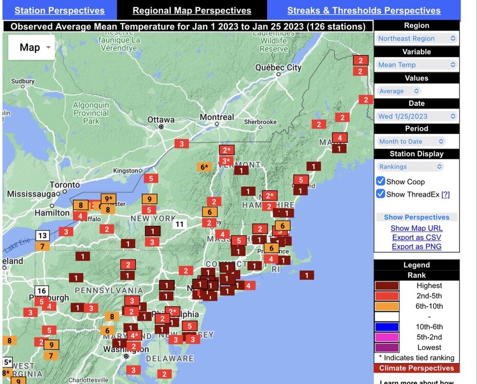
Another abysmal cold spell top remind us of this lackluster winter- 2-3 days after Ground Hogs day with virtually no snow on the ground again- the pity hits just keep coming this winter. Gotta talk about this last gasp of winter since the rest of February appears to be toasty. Even the ground Hog has a message for all of us after this cold outbreak:
-

E PA/NJ/DE Winter 2022-2023 OBS Thread
Albedoman replied to Ralph Wiggum's topic in Philadelphia Region
I am actually shocked at the image from the 18Z GFS run i just observed below. I have been alive for 64 years, lived in Wi, Tn, Ca and pretty much traveled throughout the country. Yet, it appears I will actually finally experience a great plain weather scene next weekend where the temps are near zero with no snow on the ground. I say good because every dam nuisance bug will be killed after that cold spell on our area for sure, including the ash borer, box elders, stink bug, lantern fly and maybe some mosquitoes to boot. Finally something good to talk about in the pattern. I will be looking forward to less bugs -

E PA/NJ/DE Winter 2022-2023 OBS Thread
Albedoman replied to Ralph Wiggum's topic in Philadelphia Region
This is not only bad- it is just outright disgusting. One run for the records. The LR thermals indicate us back into the 60's after the end of next week. This year will be aka "The little winter season engine that could" https://www.prindleinstitute.org/books/the-little-engine-that-could/ -

E PA/NJ/DE Winter 2022-2023 OBS Thread
Albedoman replied to Ralph Wiggum's topic in Philadelphia Region
OMG. I have to wipe the tears out of my eyes from laughing so much. The point forecast for my house tonight is literally a joke. No sunshine until Thursday. I edited it for your enjoyment too ++++++++++++++++++++++++++++++++++++++++++++++++++++++++++++++++++++++++++++++++++++++ Tonight Increasing clouds, with a low around 30. South wind 5 to 10 mph. Saturday Increasing clouds, with a high near 46. West wind 10 to 15 mph. (So it is just cloudy enough for you in the LV yet so we will keep increasing the clouds until it is?) Saturday Night Mostly cloudy, with a low around 31. South wind around 5 mph. Sunday A slight chance of rain and snow showers before 10am, then a chance of rain showers. Mostly cloudy, with a high near 47. Southwest wind 5 to 15 mph. Chance of precipitation is 30%. Little or no snow accumulation expected. (Yep it is true, snow is not allow to accumulate for longer then 8 hours in the LV before melting away) Sunday Night A slight chance of showers before 1am. Cloudy, with a low around 34. Southwest wind 5 to 15 mph becoming northwest after midnight. Chance of precipitation is 20%. Monday Mostly cloudy, with a high near 45. Monday Night Mostly cloudy, with a low around 29. Tuesday Mostly cloudy, with a high near 36. Tuesday Night A chance of snow after 1am. Partly cloudy, with a low around 25. Chance of precipitation is 40%. Wednesday A chance of snow showers, mixing with rain after 10am, then gradually ending. Partly sunny, with a high near 36. Chance of precipitation is 40%. Wednesday Night Mostly cloudy, with a low around 23. (whoopee -- ice to deal with on my car as the melted snow freezes- my favorite) Thursday Partly sunny, with a high near 33. (Hot dam-- what the hell is that yellow ball in the sky that I see today?) Thursday Night Partly cloudy, with a low around 17. Friday Sunny, with a high near 33. (Finally all day sunshine but no again snow on the ground and now it is below freezing for a high -- typical screw job) -

E PA/NJ/DE Winter 2022-2023 OBS Thread
Albedoman replied to Ralph Wiggum's topic in Philadelphia Region
-

E PA/NJ/DE Winter 2022-2023 OBS Thread
Albedoman replied to Ralph Wiggum's topic in Philadelphia Region
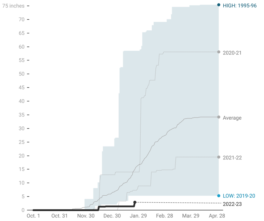
Yearly snowfall amounts in LV and where we stand this year. Pitiful as the snow we received yesterday is already gone. As far as I am concerned, its still a shutout as no snow has been on the ground for the entire day -

E PA/NJ/DE Winter 2022-2023 OBS Thread
Albedoman replied to Ralph Wiggum's topic in Philadelphia Region
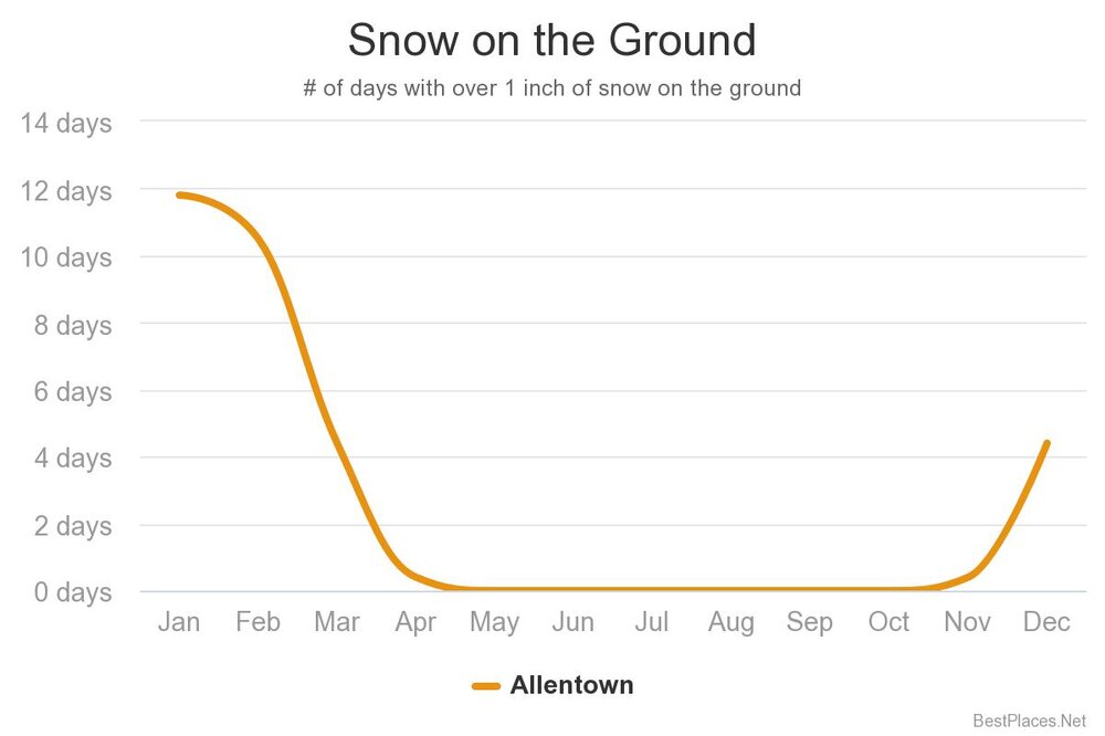
I tell you what a pathetic winter is. When it does actually snow nearly 3 inches and the snow cannot even stay on the ground for longer than 8-12 hours. The snow cover is basically gone in the LV area. We have had nearly 4 inches of snow this wonderful year and none of it has been on the ground 12 hours later. That should count for jack shite for snowfall totals Its like pulling the rug out. Somebody please provide us posters who like a good winter season with info on when the last snow that was on the ground for longer than three days in the LV or SE PA. Otherwise as far as I am concerned I am afraid this winter season is over even with yesterdays snow as I see no significant snow being on the ground longer than 24 hours on any model run period in the foreseeable future. In summation, winter is not a true winter unless snow is on the ground for longer than a week. -

E PA/NJ/DE Winter 2022-2023 OBS Thread
Albedoman replied to Ralph Wiggum's topic in Philadelphia Region
Rephrase Please "what could possibly go right!" LMAO


