Albedoman
-
Posts
1,392 -
Joined
-
Last visited
Content Type
Profiles
Blogs
Forums
American Weather
Media Demo
Store
Gallery
Everything posted by Albedoman
-

E PA/NJ/DE Spring 2023 OBS Thread
Albedoman replied to Hurricane Agnes's topic in Philadelphia Region
just received my 2-5 minute spotty light shower. Real gully washer , LMAO But alas, the bird crap is still on the sidewalk and driveway. well something is better than nothing -
E PA/NJ/DE Spring 2023 OBS Thread
Albedoman replied to Hurricane Agnes's topic in Philadelphia Region
heck no way, just enough to seal the pollen to the glass LOL -
E PA/NJ/DE Spring 2023 OBS Thread
Albedoman replied to Hurricane Agnes's topic in Philadelphia Region
Just wow. Drizzle around noon. Air too stable to even spit out enough moisture to wet the road. The front is already falling apart as I type this . May get here with just some sprinkles to wet the blades of the parched grass. Thats it. I mowed the yard and some parts are already starting to be stressed crazy but not from the heat but the lack of humidity as dewpoints are not being achieved from the dry winds. Folks, this is getting pretty serious. I see no significant rain until AFTER THE FIRST WEEK IN JUNE. The farmers just seeded the dust fields in Lehigh County with corn/soybeans. That planting will not come up for weeks now. Late harvests may have normal yields if we get good rains in late June into July especially when the soil temps were already two - three weeks behind with the cool spell in early May. Again, stream flow is my big concern. As people really start sucking water out of the ground to keep their garden going and lawn and golf course from being stressed and turning yellow so early, the water tables will fall even faster and stream flows will begin to disappear, especially in the karst topography areas of south central and eastern PA. -
E PA/NJ/DE Spring 2023 OBS Thread
Albedoman replied to Hurricane Agnes's topic in Philadelphia Region
tell the person that the Bermuda High is on Vacation until further notice. Tell her the Niagara Falls High has taken over LOL -
E PA/NJ/DE Spring 2023 OBS Thread
Albedoman replied to Hurricane Agnes's topic in Philadelphia Region
well here comes the misery time: The last day of the month indicates ont eh latest run of the GFS daytime temps rebounding from the cool 70's right into the 90 degree oven with no rain. Talk about a farmers nightmare. Seed is finally in the ground this week, no moisture to sprout the plant and now the sun bakes the dry soil even more. Not a good combination thats for sure. The lawns will begin to yellow once we get into the upper 80's at the end of the month without some rain. Just like 2002 again. -
E PA/NJ/DE Spring 2023 OBS Thread
Albedoman replied to Hurricane Agnes's topic in Philadelphia Region
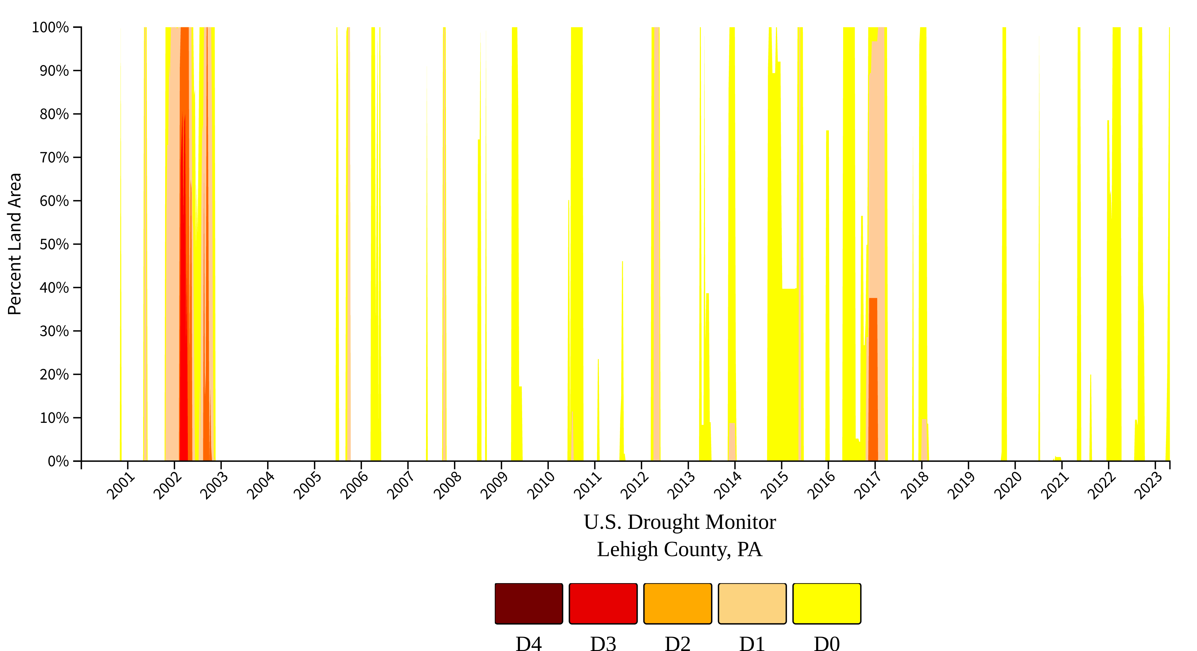
This issue is not just "droughty" but historical. Folks, we are in serious trouble for historical disappearing ephemeral streams and low major stream base flows in the next two months without some serious weather pattern change. Yes a tropical storm can change the pattern but we cannot wait until September. I am sorry to say but we need an "Agnes" type of tropical storm event in June and I just do not see that happening. Its the late 60's and early 2000's all over again. here is my proof
-
E PA/NJ/DE Spring 2023 OBS Thread
Albedoman replied to Hurricane Agnes's topic in Philadelphia Region
I know that you guys may not like to hear this, but not having any precip in two weeks in the middle of Spring is not a good thing. The heavy rain we had at the end of April only served to help green us up. The stream levels are down big time as the base flow was was not even touched in the streams, especially the LV and other karst areas of central and eastern PA. We are still in a moderate drought for streamflow. We really need days of daily convective t- storms to help recharge the stream base flows since we had no snow this year. I see no convective type weather for us until maybe the end of the first week of June, if we are lucky. You all may like this cooler 70 degree weather and little to no rain showers but believe me , the farmers sure don't. It will be another 2-3 weeks before the corn even sprouts and maybe longer if we do not get any significant rain. Corn yields will be down significantly if we do not get some type of convective weather pattern going in the next few weeks. -
for our baseball fans- umpires are going away? The Phillies LV Iron Pigs demonstrates robotic umpires this Saturday. Going to the game. Comments? https://www.lehighvalleynews.com/arts-culture/entertainment/from-man-to-machine-ironpigs-prepare-for-debut-of-robot-umpires
-
E PA/NJ/DE Spring 2023 OBS Thread
Albedoman replied to Hurricane Agnes's topic in Philadelphia Region
When will we see crackin t -storms again? Its been so long it seems like years. These piddly rain showers with embedded heavier rain is pathetic. I want all of the tree pollen bags off the trees and not dangling in the limbs just to pour out in a slight breeze. -
E PA/NJ/DE Spring 2023 OBS Thread
Albedoman replied to Hurricane Agnes's topic in Philadelphia Region
in my 35+ years of living here, I have never seen a chance of snow this close to the LV in May. The current radar indicates snow/rain mix near Hazleton but the NWS is even calling for thunder snow/mix in the point forecast for the Jim Thorpe area. Really unique. I hope this a tell tale sign for next winter. Today Showers likely, mainly between 10am and 2pm. Cloudy, with a high near 46. West wind 10 to 15 mph. Chance of precipitation is 70%. New precipitation amounts of less than a tenth of an inch possible. Tonight A chance of rain showers before 4am, then a chance of rain and snow showers. Mostly cloudy, with a low around 36. West wind around 10 mph. Chance of precipitation is 30%. Little or no snow accumulation expected. Wednesday Rain likely, possibly mixed with snow showers before 8am, then rain showers. Some thunder is also possible. High near 48. West wind around 5 mph. Chance of precipitation is 80%. Little or no snow accumulation expected. -
E PA/NJ/DE Spring 2023 OBS Thread
Albedoman replied to Hurricane Agnes's topic in Philadelphia Region
I am here. I watch this page daily. Nothing to comment on as it has been pretty stagnant weather so far. I want to see some convective production with temps in the low 80's. Yes, this weekends rain will put in a moderate dent in our rainfall deficit but the base stream flows are down big time because of the lack of snow cover this past winter. We need weeks of this type of moderate rain to put a significant dent in the drought. The trees, grass and gardens are drinking big time right now as they green up but the groundwater levels are still falling. -
E PA/NJ/DE Spring 2023 OBS Thread
Albedoman replied to Hurricane Agnes's topic in Philadelphia Region
I can validate this big time. My severe short term drought is over after today. I live in the Ancient Oaks area. My rain gauge had 3.5 in of rain. I was at my sons house near Telford all day , - he received only .05 in. When I got home this evening, I was floored . Debris from the flooded street was in my driveway. Had a little water in the basement. That is hardest rain in four years here. I am just glad that we got rain. That was a million dollar plus rain for the farmers in western LV. Salisbury Township and areas near my house had quarter size hail and flooded streets. The pollen was knocked off the trees and I can breathe again. -
E PA/NJ/DE Spring 2023 OBS Thread
Albedoman replied to Hurricane Agnes's topic in Philadelphia Region
Brush fire in eastern Berks County threatens homes Crews responded to a 3- to 4-acre brush fire in the area of Huffs Church Road and Cherry Drive in District Township Brush fire in eastern Berks County threatens homes By KEITH DMOCHOWSKI | [email protected] | Reading Eagle PUBLISHED: April 12, 2023 at 3:21 p.m. | UPDATED: April 12, 2023 at 4:44 p.m. Fire crews responded Wednesday afternoon to a two-alarm brush fire in the area of Cherry Drive and Huffs Church Road in District Township. Calls around 2:10 p.m. reported a 3- to 4-acre fire moving toward properties on Cherry Drive. Crews from multiple fire companies responded shortly after, and a second alarm was struck. An air drop was requested about 2:50 p.m. and numerous spot fires were reportedly breaking out. Firefighters were battling the flames with several hose lines as well as leaf blowers, and water was drawn from a large pond on Cherry Lane, according to emergency reports. Additional assistance was requested from Montgomery and Lehigh County fire departments. The flames were stopped by a creek on one side, and crews were containing the blaze and awaiting an imminent air drop at 3:40 p.m. The airdrops largely extinguished the active fire, and crews were moving back in for cleanup at 4:15 p.m. More information will be provided as it becomes available. -
E PA/NJ/DE Spring 2023 OBS Thread
Albedoman replied to Hurricane Agnes's topic in Philadelphia Region
https://www.lehighvalleynews.com/environment-science/lehigh-valley-under-red-flag-warning-as-massive-fire-burns-in-new-jersey -
E PA/NJ/DE Spring 2023 OBS Thread
Albedoman replied to Hurricane Agnes's topic in Philadelphia Region
One of the most prevalent varieties of pine trees in PA is “Pinus strobus,” commonly known as the Eastern White Pine. This pine tree is tall – growing quickly to a height of up to 100’ – with a full crown of dark needles and pinecones that drop every year. If you haven’t noticed the pinecones on the tree, you’ve certainly noticed them on the ground! Especially this year. Have you ever wondered “why are there so many pinecones this year?” It boils down to survival. Trees have different reactions based on the climate and weather around them. In years with a healthy amount of rain, the tree will focus more on growth and less on seed production. However, in years where there just isn’t enough rain (like this past winter/spring) the tree will compensate by producing an abnormal number of seeds (to encourage propagation). On a pine tree, these seeds are found in pinecones that will eventually drop to the ground. -
E PA/NJ/DE Spring 2023 OBS Thread
Albedoman replied to Hurricane Agnes's topic in Philadelphia Region
URGENT - FIRE WEATHER MESSAGE National Weather Service Mount Holly NJ 924 AM EDT Wed Apr 12 2023 PAZ054-055-060>062-070-071-101>106-130000- /O.UPG.KPHI.FW.A.0001.230412T1500Z-230413T0000Z/ /O.NEW.KPHI.FW.W.0002.230412T1500Z-230413T0000Z/ Carbon-Monroe-Berks-Lehigh-Northampton-Delaware-Philadelphia- Western Chester-Eastern Chester-Western Montgomery- Eastern Montgomery-Upper Bucks-Lower Bucks- 924 AM EDT Wed Apr 12 2023 ...RED FLAG WARNING IN EFFECT UNTIL 8 PM EDT THIS EVENING FOR GUSTY WINDS AND LOW RELATIVE HUMIDITY FOR EASTERN PENNSYLVANIA... The National Weather Service in Mount Holly has issued a Red Flag Warning for gusty winds and low relative humidity, which is in effect until 8 PM EDT this evening. The Fire Weather Watch is no longer in effect. * AFFECTED AREA...Carbon, Monroe, Berks, Lehigh, Northampton, Delaware, Philadelphia, Western Chester, Eastern Chester, Western Montgomery, Eastern Montgomery, Upper Bucks and Lower Bucks. * TIMING...Wednesday. * WINDS...West 10 to 15 mph with gusts up to 30 mph. * RELATIVE HUMIDITY...As low as 25 percent. * TEMPERATURES...Afternoon high temperatures in the upper 70s to low 80s. * IMPACTS...Critical fire weather conditions are expected. There will be increased risk for rapid wildfire growth and spread. PRECAUTIONARY/PREPAREDNESS ACTIONS... A Red Flag Warning means that critical fire weather conditions are either occurring now, or will shortly due to a combination of strong winds, low relative humidity, and dry fuels. Any fires that develop may quickly get out of control and become difficult to contain. -
E PA/NJ/DE Spring 2023 OBS Thread
Albedoman replied to Hurricane Agnes's topic in Philadelphia Region
PAZ054-055-060>062-070-071-101>106-121015- /O.NEW.KPHI.FW.A.0001.230412T1500Z-230413T0000Z/ Carbon-Monroe-Berks-Lehigh-Northampton-Delaware-Philadelphia- Western Chester-Eastern Chester-Western Montgomery- Eastern Montgomery-Upper Bucks-Lower Bucks- 346 PM EDT Tue Apr 11 2023 ...FIRE WEATHER WATCH IN EFFECT FROM WEDNESDAY MORNING THROUGH WEDNESDAY EVENING FOR GUSTY WINDS AND LOW RELATIVE HUMIDITY FOR EASTERN PENNSYLVANIA... The National Weather Service in Mount Holly has issued a Fire Weather Watch for gusty winds and low relative humidity, which is in effect from Wednesday morning through Wednesday evening. * AFFECTED AREA...Carbon, Monroe, Berks, Lehigh, Northampton, Delaware, Philadelphia, Western Chester, Eastern Chester, Western Montgomery, Eastern Montgomery, Upper Bucks and Lower Bucks. * TIMING...Wednesday. * WINDS...West 10 to 20 mph with gusts up to 25 mph. * RELATIVE HUMIDITY...As low as 30 percent. * TEMPERATURES...In the lower 80s. * IMPACTS...Critical fire weather conditions are expected. There will be increased risk for rapid wildfire growth and spread. PRECAUTIONARY/PREPAREDNESS ACTIONS... A Fire Weather Watch means that critical fire weather conditions are forecast to occur due to a combination of strong winds, low relative humidities, and dry fuels. Listen for later forecasts and possible Red Flag Warnings. -
E PA/NJ/DE Spring 2023 OBS Thread
Albedoman replied to Hurricane Agnes's topic in Philadelphia Region
yep, the drought weenie called it LOL 249 AM EDT Tue Apr 11 2023 ...ELEVATED RISK OF WILDFIRE SPREAD THIS AFTERNOON AND EARLY THIS EVENING... A combination of low relative humidity, gusty westerly winds, and dry fine fuels will lead to an elevated risk for fire spread with any potential fire starts this afternoon across New Jersey and southeast Pennsylvania. Minimum relative humidity values this afternoon will range from 20 to 25 percent across the region. Winds will be sustained from 10 to 15 mph with gusts around 20 to 25 mph, highest around mid to late afternoon. Fine fuel moisture may be somewhat of a limiting factor, mainly across southern New Jersey, due to rainfall last Friday. Residents are urged to exercise caution if handling any potential ignition source, including machinery, cigarettes, and matches. Be sure to properly discard all smoking materials. Any dry grasses, dead leaves, and other tree litter that ignite will have the potential to spread fire quickly. For more information about wildfire danger, burn restrictions, and wildfire prevention and eduction, please visit your state`s forestry or environmental protection website. -
E PA/NJ/DE Spring 2023 OBS Thread
Albedoman replied to Hurricane Agnes's topic in Philadelphia Region
Red Flag warnings a coming by next weekend. Underbrush fires appear to be a problem this week. -
E PA/NJ/DE Spring 2023 OBS Thread
Albedoman replied to Hurricane Agnes's topic in Philadelphia Region
wow, a retrograding low at the end of the forecast period- pretty rare for this time of the year. Cloudy cool days with drizzle- how boring -
E PA/NJ/DE Spring 2023 OBS Thread
Albedoman replied to Hurricane Agnes's topic in Philadelphia Region
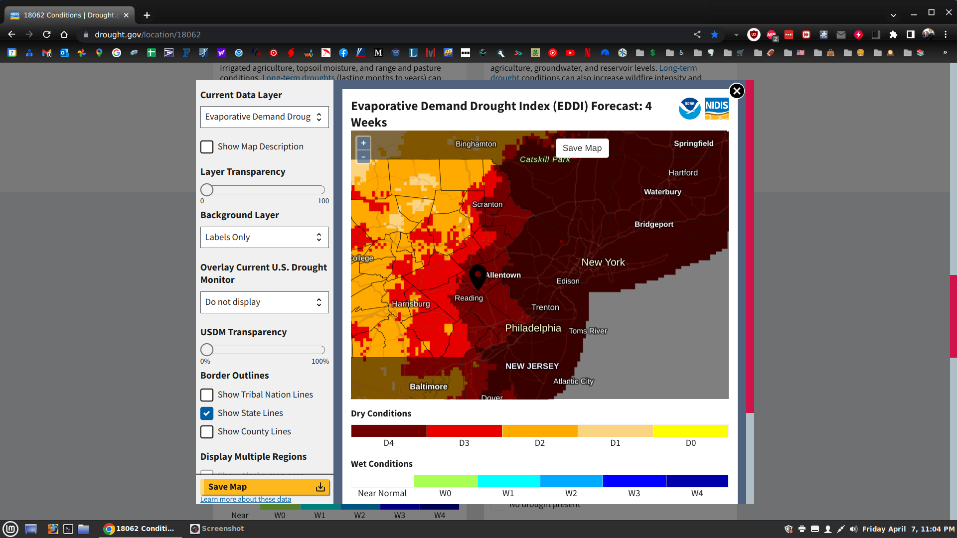
believe me, after this week, this map will change big time. Much of this info is based on existing USGS streamflow, well yields data and evap rates. When the water resources are getting sucked out of the ground by our citizens through watering their gardens/lawns/golf courses, washing their vehicles to get the constant pollen and dust off their vehicles (yellow and green haze- which by the way will seem unusually thick this year) and basic spring cleaning chores along with drinking more water because it will be in the mid 80's next week, that map will be history. The models indicate one slim chance of rain on or near the 19th and thats it for the next 10-15 days. We really need a Noreaster right now with 2-3 in rains over several days. The farmers will be plowing dust in the air in the next few weeks. I will bet somewhere in our region, , the media will take pictures of the excessive pollen dust on the vehicles or the plows blowing up dust storms. Thats how they work-- sensationalism. -
E PA/NJ/DE Spring 2023 OBS Thread
Albedoman replied to Hurricane Agnes's topic in Philadelphia Region
can you say sucking the living hell out of the soil moisture and lowering the groundwater tables in the next 4 weeks.
-
E PA/NJ/DE Spring 2023 OBS Thread
Albedoman replied to Hurricane Agnes's topic in Philadelphia Region
the infamous winter donut hole LMAO -
E PA/NJ/DE Spring 2023 OBS Thread
Albedoman replied to Hurricane Agnes's topic in Philadelphia Region
too late, we are all getting stung. I see no appreciable rainfall in the next week or so. I believe drought watches will be hoisted by the end of next week as stream flow levels are in drought conditions already exist in our area. The wells levels will drop significantly as people begin to water their plants and gardens as the releafing process is ongoing this next week. Less than .25 inch of rain tonight is not cutting it- just dusting down the parched soils. I expect that we are in the beginning of a nasty drought coming at the end of the this La Nina year which is very typical and I have been stating this all winter in this thread. -
E PA/NJ/DE Spring 2023 OBS Thread
Albedoman replied to Hurricane Agnes's topic in Philadelphia Region
Nice cloud to ground lightning, gusty winds but what the hell, hardly any rain. All day long, only received less than . 50 in the bucket. I have seen a much worse storm in the Lehigh Valley thats for sure. C'mon I need at least 1-2 inches of rain on Wednesday. The stiff NW winds today will parch everything pretty quickly. We really need a rain producer before the trees releaf.