Albedoman
-
Posts
1,372 -
Joined
-
Last visited
Content Type
Profiles
Blogs
Forums
American Weather
Media Demo
Store
Gallery
Everything posted by Albedoman
-

E PA/NJ/DE Winter 2023-2024 OBS/Discussion
Albedoman replied to The Iceman's topic in Philadelphia Region
I am not the only one saying this either ------below is also from the respected meteorologist from the Pit. central PA forum ++++++++++++++++++++++++++++++++++++++++++++++++++++++++++++++++++++++++++++++++++++++++++++++++++++++++++++++++++++++ I definitely like the look of the pattern from a 500mb standpoint with the below average heights over the southern US with above in Canada, eventually progged to center west of Hudson Bay in central (and then western) Canada . We’ll eventually score something if we continue to maintain that suppressed storm track look, which is generally shown across the guidance. My big problem for the time being is temps. It’s going to rear it’s ugly head again with the storm next week that has been pretty consistently on guidance in that Dec 27-28ish period. Gonna try to cut but it looks like it’s going to be forced to reform on the coast. If say today’s 12z GFS scenario played out there’s no decent antecedent cold air in place with the initial low trying to drive well west and the coastal beginning to form and it’s too far displaced N for the northeasterly flow of the coastal to draw it down (similar to what just happened). That storm looks to be a part of the overall pattern reshuffle but I don’t think we’re going to have a snow threat out of it, certainly not in the Sus Valley but probably not in this part of PA either. Notably above average temps in Canada and X amount of the Northern US depending on the flavor of longer range model guidance (weeklies, GEFS extended) has been a constant theme. As such I don’t expect a big time arctic air intrusion probably thru at least mid month Jan. Not that we need it, but the big thing that you can see now in regular ensemble guidance is the 500 ridging shifting to western Canada by about New Years. That would at least ensure airmass source directed from Canada and not the Pac, which should get us cold enough to pair up with a storm track which has honestly been pretty favorable for us this season so far. paweather, Mount Joy Snowman, canderson and 1 other 4 Quote Michael Glunt PSU class of '10 -
E PA/NJ/DE Winter 2023-2024 OBS/Discussion
Albedoman replied to The Iceman's topic in Philadelphia Region
by the way, the LR GFS keeps kicking any potential weather pattern change into the second week of January since before Thanksgiving . I have given up any hope of cold air coming our way. When the PAC jet is raging, LR models go literally to shit and you can only rely on 3-5 day models for any pattern changes. -
E PA/NJ/DE Winter 2023-2024 OBS/Discussion
Albedoman replied to The Iceman's topic in Philadelphia Region
zilcho snow in macungie. Creek still flooded. Again, no artic air until mid january means little chance of snow on the ground for more than 3 days anyway. Drenching rain , flurries, brief cold warm up and then drenching rain again. Typical Tn Valley weather we are having above the mason dixon line. I will go out and say our first big 3-5 inch accumulating snow in our area will be with associated with clipper if we even get one before the first week in January. Simply no arctic air to intrude in these Nor'easters -
E PA/NJ/DE Winter 2023-2024 OBS/Discussion
Albedoman replied to The Iceman's topic in Philadelphia Region
drought over LMAO 3.80in. and still pouring. Roads closed all around Ancient Oaks , even RT 222 off ramps -
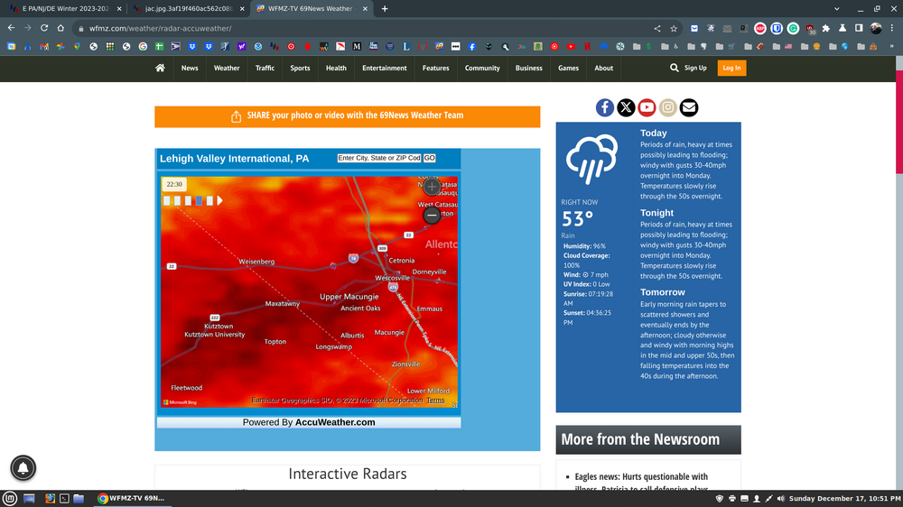
Moderate-High Impact Storm Noon Sun Dec 17, 2023 - 4PM Mon Dec 18. Flooding rain I95 corridor northwestward, coastal tidal flooding, brief periods of damaging 50 MPH+ wind gusts LI/CT Monday, ends as a little wet snow interior elevations Tue morning.
Albedoman replied to wdrag's topic in New York City Metro
lehigh valley getting crushed with rain. Over 2 in and still pouring for the next 3 hours- radar indicates a wave of water coming at us. Flooding now occurring everywhere -
E PA/NJ/DE Winter 2023-2024 OBS/Discussion
Albedoman replied to The Iceman's topic in Philadelphia Region
on cue. approaching 2 inches inches of rain. Flood warning by 5am should be issued next as Little Lehigh is already out of its banks in my backyard. PAC077-095-181045- /O.EXT.KPHI.FA.Y.0216.000000T0000Z-231218T1045Z/ /00000.N.ER.000000T0000Z.000000T0000Z.000000T0000Z.OO/ Lehigh PA-Northampton PA- 210 AM EST Mon Dec 18 2023 ...FLOOD ADVISORY NOW IN EFFECT UNTIL 545 AM EST EARLY THIS MORNING... * WHAT...Flooding caused by excessive rainfall continues. * WHERE...A portion of east central Pennsylvania, including the following counties, Lehigh and Northampton. * WHEN...Until 545 AM EST. * IMPACTS...Minor flooding in low-lying and poor drainage areas. Rises in small streams and normally dry arroyos. Water over roadways. Overflowing poor drainage areas. Some low-water crossings may become impassable. * ADDITIONAL DETAILS... - At 209 AM EST, Doppler radar indicated heavy rain. Minor flooding is ongoing or expected to begin shortly across portions of the advisory area. Between 1 and 2 inches of rain have fallen. An additional inch of rain will fall. - Some locations that may experience flooding include... Allentown, Bethlehem, Northampton, Hellertown, Lehigh University, Catasauqua, Fountain Hill, Coplay, North Catasauqua, Freemansburg, Fullerton, and Hokendauqua. - This includes Interstate 78 in Pennsylvania between mile markers 62 and 67. - http://www.weather.gov/safety/flood -
E PA/NJ/DE Winter 2023-2024 OBS/Discussion
Albedoman replied to The Iceman's topic in Philadelphia Region
-
E PA/NJ/DE Winter 2023-2024 OBS/Discussion
Albedoman replied to The Iceman's topic in Philadelphia Region
pouring its ass off right now in Macungie . Creek levels coming up quickly. Flash flood advisory should be issued in the next hour or so -
E PA/NJ/DE Winter 2023-2024 OBS/Discussion
Albedoman replied to The Iceman's topic in Philadelphia Region
those guys in the NYC forum are bonkers- 5-7 inches. They are dry slotted right now. -
E PA/NJ/DE Winter 2023-2024 OBS/Discussion
Albedoman replied to The Iceman's topic in Philadelphia Region
a bunch of BS for any snow until next year. The models cannot even agree right now from run to another eight hours later. 3 consecutive runs at 36 hours before the event showing accumulating snow - thats believable. Until then hook line and sinker for the gullible ones -
E PA/NJ/DE Winter 2023-2024 OBS/Discussion
Albedoman replied to The Iceman's topic in Philadelphia Region
I think payback time with the increased snow chances will be coming around Martin Luther KIng's Birthday. Otherwise, until then - welcome to the typical winter for Tn cold with rainy conditions. -
E PA/NJ/DE Winter 2023-2024 OBS/Discussion
Albedoman replied to The Iceman's topic in Philadelphia Region
yep, local storm reports confirm my outcome. Strictly elevation driven snowfall along S Mtn. Snows gone anyway Gusty winds now from the LP winding up in Maine ..Pennsylvania... ...Berks County... Huffs Church 2.3 in 0725 AM 12/11 Public Alburtis 4.7 SW 2.2 in 0700 AM 12/11 COCORAHS Fleetwood 2 ESE 1.3 in 0700 AM 12/11 COCORAHS New Morgan 1.8 WNW 1.3 in 0800 AM 12/11 COCORAHS Fleetwood 4.8 ESE 1.1 in 0700 AM 12/11 COCORAHS Mohnton 2.8 SSW 0.8 in 0800 AM 12/11 COCORAHS Hamburg 0.1 in 0700 AM 12/11 COCORAHS Reading 3.5 SW 0.1 in 0700 AM 12/11 COCORAHS ...Bucks County... 1.2 NE Springtown 0.8 in 0715 AM 12/11 COOP ...Carbon County... Lake Harmony 2.4 WNW 4.6 in 0700 AM 12/11 COCORAHS 1 E Christmans 4.0 in 0547 AM 12/11 Public Jim Thorpe 0.2 in 0700 AM 12/11 COCORAHS ...Chester County... West Caln Twp 1.5 in 0700 AM 12/11 Trained Spotter East Nantmeal Twp 0.8 in 0708 AM 12/11 Trained Spotter ...Lehigh County... Salisbury Twp 2.0 in 0820 AM 12/11 Trained Spotter Macungie 0.3 in 0618 AM 12/11 Trained Spotter Lehigh Valley International T in 0700 AM 12/11 ASOS -
E PA/NJ/DE Winter 2023-2024 OBS/Discussion
Albedoman replied to The Iceman's topic in Philadelphia Region
snow all gone- melted as soon as the sun popped out. 2.6 in of rain here for the storm total with some flooding. Nothing too bad. No more rain/snow until next year on the LR worth looking at -
E PA/NJ/DE Winter 2023-2024 OBS/Discussion
Albedoman replied to The Iceman's topic in Philadelphia Region
strictly elevation driven. Ridges on S mtn 2-3 inches maybe LV floor allentown coating to an inch. The cold air is just not deep enough and is taking its time getting here -
E PA/NJ/DE Winter 2023-2024 OBS/Discussion
Albedoman replied to The Iceman's topic in Philadelphia Region
real disappointed, no convective issues. Just not unstable enough. Winds are really not bad either. 1-3 in for snow still in the cards however. The heavy rain total thus far is over 1.5 now easily and still moderate rain. I see a flood advisory maybe for my area if the rain keeps up. Cold front has come through with temps falling into low to mid 40's in macungie. -
E PA/NJ/DE Winter 2023-2024 OBS/Discussion
Albedoman replied to The Iceman's topic in Philadelphia Region
After seeing this morning NAM runs- my original forecast 1-3 in of snow for the LV northern Bucks Montgomery areas yesterday morning seems the best outcome. I have got learn to stick to my original guns. The ground will be simply too wet an and warm to support higher amounts as it really needs to snow hard to even accumulate. The ridges around the LV will see some accumulation especially Bear Creek ski resort area in Macungie. It really does not matter anyway as this stuff as most of it will be gone by the evening when the sun pops out. 2-3 inches of rain will really get the feet wet for vegetation before a good cold snap hits later in december. I think the 40 mph wind gusts with the heavy rain will feel awful this evening too. Personally rather see a good line of convectivness with a squall line thunderstorm. It seems that we have not had a thunderstorm in 4 months. 1-3 inch snow may seem a lot now to ask for but asking for a good t storm seems to be more of a challenge -
E PA/NJ/DE Winter 2023-2024 OBS/Discussion
Albedoman replied to The Iceman's topic in Philadelphia Region
my quote for this morning still holds. This old geezer here is telling you all that this storm is dynamically an open door policy for snow for extreme snow growth generation- I have seen this situation unfold a dozen times in my 45 years of forecasting as a hobby. Half dollar flakes and bigger- pancake flakes? as the snow growth should be incredible for some areas as well as for the higher elevations. The key is whether the cold can be sucked down quick enough for the precip to change to allow for accumulation and if the LP coastal forms more east in the Chesapeake Bay. Thunder snow maybe? But it could fall apart if the LP forms further west. I would love to see 2-4 inch rates of snow per hour but I really think a good thumping of snow for a few hours at 2-3 " or more per hour is all that can get squeezed out before the LP races off to the NE. I Any snow will be pretty as the limbs will have a nice paste job with the gusty winds in place. The changeover will be quick too. -
E PA/NJ/DE Winter 2023-2024 OBS/Discussion
Albedoman replied to The Iceman's topic in Philadelphia Region
a very clear sign that tomorrow afternoon/evening is going to be a royal rumbler with flooding rains. The atmosphere is loading up for the show with all of the warm air advection going on. Seen this scenario unfold many times in December. T storms, squall lines and very damaging winds coming our way. I will state emphatically right now that since this storm will be so dynamic with all of this moisture loading up at this time of the year and the fact it is already in the mid 40's at my house this morning., we will be under severe t- storm watch tomorrow afternoon , mostly for damaging straight line winds. The flooding rains will be the main by product this time but you will not forget about the winds. The front is so dynamic that I also say half dollar size snowflakes with a 1-3 inches of snow and very gusty winds will be on our doorstep Monday morning is very possible scenario for the LV and northern Montgomery/Bucks area. -
E PA/NJ/DE Winter 2023-2024 OBS/Discussion
Albedoman replied to The Iceman's topic in Philadelphia Region
If many of the posters are like me, we are all sick and tired of looking at model runs that indicate snow at one run and 12 hrs later zilch. The only model run worth looking at this time is the NAM/ HRR at 36 hours. I am also so sick of seeing daily forecasts bust in the past several months for sky conditions as well. P Sunny does not mean 98% cloudy. So many wasted days under cloudy skies the last four months that were supposed to be mostly sunny. Its like we live in the far west as high cirrus/altostratus clouds covering the entire sky with a milky appearance is rare for us but has happen a dozen times in the past month. It does bring nice sunset colors though. I am ready for a good old fashion Miller A storm. The GOM has been shut down for so long as we could not even get a decent tropical storm this year up in our area. I am telling you this, as the old timer of the forum, this current weather pattern has all of the appearances of another type of Superstorm of 93 forming. It was dead city around here until that storm formed in the northern GOM near the panhandle of Fla. I believe another storm will form in the same area this winter and present the same issues. Not quite as stong but the pattern is leaning in that direction. Just hoping for some snow before Christmas. The Dec 18-21 time period looks promising but the event keeps being kicked down the road. I am hoping or least a few clippers this year too to keep the topping fresh -
E PA/NJ/DE Fall 2023 OBS/Discussion Thread
Albedoman replied to Rtd208's topic in Philadelphia Region
yes its only one model run but the writing is all over the wall. Dec 5-8 usually is the first accumulating snowfall event for the area--- aka Pearl harbor day snow bombing run. This year is no different. I will be more hopeful if I see this same scenario unfolding as below on the model runs on Friday. These models have been hinting some type of snow event for the last week in the same time frame but they keep appearing and disappearing on each model run. -
E PA/NJ/DE Fall 2023 OBS/Discussion Thread
Albedoman replied to Rtd208's topic in Philadelphia Region
The last two days of model runs have really gone downhill for snow production in the LV in the first week of December . I hope that changes after this storm passes. The 10 minutes of light sleet this morning should have been called "mood Pellets" -
E PA/NJ/DE Fall 2023 OBS/Discussion Thread
Albedoman replied to Rtd208's topic in Philadelphia Region
The evapotranspiration rates have been negligible the last few weeks as the colder nights reaching dew points have set in. In other words, not much of the stream flow is being utilized from the lack of intense heat now. The second main reason is that leaf photosynthesis production as ceased, thus ground water water is not being pulled out the soil for the tree roots. The combination has help keep the stream flows going. Tonights rain is a lifesaver and helps get the trees feet wet before the soil freezes in the next two weeks plus keep wildfire threats down. -
Central PA Autumn 2023
Albedoman replied to Itstrainingtime's topic in Upstate New York/Pennsylvania
Channel 69 news ran with this BS tonight. Boy the weenies are coming to the surface now. https://www.wfmz.com/news/area/lehighvalley/69-news-meteorologist-discusses-european-weather-model-forecasting-december-snow-in-lehigh-valley-that-took/article_7af2db2c-8263-11ee-bfee-7b74ff14fc43.html -
E PA/NJ/DE Fall 2023 OBS/Discussion Thread
Albedoman replied to Rtd208's topic in Philadelphia Region
well I posted this on saturday- guess what Channel 69 picks it up this evening and runs with the story with a video too LMAO big time now. https://www.wfmz.com/news/area/lehighvalley/69-news-meteorologist-discusses-european-weather-model-forecasting-december-snow-in-lehigh-valley-that-took/article_7af2db2c-8263-11ee-bfee-7b74ff14fc43.html -
E PA/NJ/DE Fall 2023 OBS/Discussion Thread
Albedoman replied to Rtd208's topic in Philadelphia Region
for the ultimate snow weenie in all of us. This was pushed out in the EC models for snow amounts at Christmas. Give me a break. Talk about a dream run. This BS run beats all of the EC runs for the weenies. One hell of a Christmas wish. Having fun LMAO