Albedoman
-
Posts
1,380 -
Joined
-
Last visited
Content Type
Profiles
Blogs
Forums
American Weather
Media Demo
Store
Gallery
Everything posted by Albedoman
-

Two Mdt to high impact events NYC subforum; wknd Jan 6-7 Incl OBS, and mid week Jan 9-10 (incl OBS). Total water equiv by 00z/11 general 2", possibly 6" includes snow-ice mainly interior. RVR flood potential increases Jan 10 and beyond. Damaging wind.
Albedoman replied to wdrag's topic in New York City Metro
lets wait for the NAM run on Wed evening. The potential for accumulating snow is there for sure but WSW criteria will be hard to achieve even in Allentown. We first want to get a better picture for the exact transfer location (sweetspot) nd HP energy in Quebec. The we can talk how much. 48 hours from now will tell us everything on the NAM -
Two Mdt to high impact events NYC subforum; wknd Jan 6-7 Incl OBS, and mid week Jan 9-10 (incl OBS). Total water equiv by 00z/11 general 2", possibly 6" includes snow-ice mainly interior. RVR flood potential increases Jan 10 and beyond. Damaging wind.
Albedoman replied to wdrag's topic in New York City Metro
I agree with your analysis. The biggest issue IMHO for this event --- if the snow falls Saturday afternoon into the evening as currently shown, the ground melting will cave quickly. I can easily see us reaching a foot if that happens by Sunday mid morning especially if dendritic growth becomes expansive. and if any frontogenesis occurs too. I will assume that the moisture content of the snowflake itself will be very high too. That will lead to serious medical issues throughout the region as many are not used to shoveling wet heavy snow in the last 3-4 years because of the light in moisture content with snowfalls in the past La Nina years. I too rely on the positive snow depth change totals in the 5 day LR models then work up from there based on the aforementioned factors. The NAM models as well as the HRRR models will fine tune and sniff out the final snow accumulations, usually with 36-48 hours of the event . In my past years forecasting , I alway relied on the LR Euro at 5 days and if the SR NAM backed the totals too, it was pretty a dam accurate forecast for snowfall events.- 3,610 replies
-
- 2
-

-
- snow
- heavy rain
- (and 5 more)
-
E PA/NJ/DE Winter 2023-2024 OBS/Discussion
Albedoman replied to The Iceman's topic in Philadelphia Region
for shitz and giggle Old Henry Margusity is throwing out this snow map. C'mon man, the storm has not even shown up on the NAM models yet -
Two Mdt to high impact events NYC subforum; wknd Jan 6-7 Incl OBS, and mid week Jan 9-10 (incl OBS). Total water equiv by 00z/11 general 2", possibly 6" includes snow-ice mainly interior. RVR flood potential increases Jan 10 and beyond. Damaging wind.
Albedoman replied to wdrag's topic in New York City Metro
Walter Drag, I find this really unusual that Henry would post such a map in a topsy turvy weather pattern we are in right now. There is no set weather pattern at this time This amount of snow he is depicting is not even on the NAM 84 hours yet? This type of snow hype is nonsensical. Whatever happened to realistic forecasting? -
Two Mdt to high impact events NYC subforum; wknd Jan 6-7 Incl OBS, and mid week Jan 9-10 (incl OBS). Total water equiv by 00z/11 general 2", possibly 6" includes snow-ice mainly interior. RVR flood potential increases Jan 10 and beyond. Damaging wind.
Albedoman replied to wdrag's topic in New York City Metro
thanks just want to give you guys a heads up- 3,610 replies
-
- 2
-
-
- snow
- heavy rain
- (and 5 more)
-
Two Mdt to high impact events NYC subforum; wknd Jan 6-7 Incl OBS, and mid week Jan 9-10 (incl OBS). Total water equiv by 00z/11 general 2", possibly 6" includes snow-ice mainly interior. RVR flood potential increases Jan 10 and beyond. Damaging wind.
Albedoman replied to wdrag's topic in New York City Metro
walt as the old timer around here, I absolutely agree with you. The consequences of a 8-12 in snow then a 2-4 inch follow up rain event would be disastrous to the Lehigh Valley. I have recorded over 11 inches of rain in December already with another five inches of precipitable water in wet snow and rain hitting the ground will produce widespread riverine flooding and not just local streams. The karst ghost lakes have also appeared in the karst areas of the LV with roads still under water in places three days after last weeks rain. This is the fist time I have see them in over five years and they usually appear after the ground has been frozen. The ground is not frozen yet which is a real concern and justifiably so. So what does this mean? The Delaware, Raritan, Schuylkill and Passaic rivers will be flooding big time if the second storm becomes a firehose. All the media crap of an atmospheric river present in California will be nothing to what we have experienced the last 45 days here in eastern PA/NJ with flooding rains and the the what the models are depicting. This is absolutely historical in nature and you are spot on by your synopsis. In my 45+ years of meteorological experience, I have only seen such a flooding scenario open up like what is being modeled and that was January 96 and believe me if this scenario unfolds as the models are hinting , we will see a 96 redux of this historical flooding situation again in our region. Many of the posters in these forums were in diapers or not even born in 96 and have no idea how bad the flooding can be. I will be watching closely believe me- 3,610 replies
-
- 12
-
-

-
- snow
- heavy rain
- (and 5 more)
-
E PA/NJ/DE Winter 2023-2024 OBS/Discussion
Albedoman replied to The Iceman's topic in Philadelphia Region
Posted on Dec 27 for those who are dejected and wishing to cancel winter based on the latest model runs do not fret ---- I am an historical meteorologist . You may ask what the hell is that? I rely on my personal weather pattern experiences over the last 50 years since I have been old enough to enjoy the knowledge of weather since I was 12 years old. I learned much weather from uncle who was the regional head forecasting meteorologist for NOAA (NWS) in the western US. I also was an air traffic controller in the Navy and graduated with a BS physical geography degree with a concentration in atmospheric science(Before many meteorological schools were even around). I do not rely solely LR daily model runs until the storms are within 48-72 hours period. Anything else is simply conjecture. I only rely on LR models to help establish the future temp/precip ranges and the possibilities of changes in the long term weather patterns. That is it. I was using my personal experiences and senses in the early 70's to 80's when there were no daily 8 hour model runs and the only models were spit out in a past weekly bulletin on the weeks previous storm events. I spent more time analyzing the storm patterns such as neutral, el nino and la nina patterns instead of relying just on LR computer model ensembles. Weather has been boiled down to a simple game of statistical chances by using computer model ensembles. Right or wrong, I side with past history Right now I see nothing but cold polar air bottled up in northern Canada with pacific cold fronts flowing zonally across the country Alberta Canada is where we get our cold air from except for an occasional backdoor cold front. There is nada coming from either direction right now. The southern jet stream is buckling but the northern stream will not come down into mid USA period to phase and deepen the lows. Until we get an LP over Alberta forming a clipper bringing that locked up polar air in Canada to the central US and introducing a potential pattern change, there is nothing we can do but watch models kick the potential 3-6 in snow events further into the 10-15 day time frame. WE must have sustainable cold- WE HAVE NONE. The potential of a 2-4 or 3-6 in snow event keeps showing up during the Jan 9-11 time frame but that is all it is. When I see it show up on the NAM at 36 hours- thats doable IMHO. My past personal history for those who believe in what I do, compares this year to 1993 where we had a crappy el nino winter 2-4 inches of snow until late February where we did get some accumulating snow event followed by the March superstorm which was a triple phaser. The el nino years below in a sample ranking chart . Please note 1958 has been thrown in the rankings for your forum too in February. (Morgantown blizzard) The winters are definitely back loaded for heavy snow sure in these years with some cold. It is just that we usually get cold sustainable cold in neutral years from the passage of continuous clippers as the el nino pattern is dying-- last gasp storm event before going into a neutral year. Remember how the severe cold in early 1994 set in that was attributable from weakening neutral year with the combination of MT Pinatubo eruption? We have not had a neutral winter in a long time. 3+ years. Lets see what the second to third week of January can throw at us? Yes once this event is in Wednesday evening's run on the NAM, I will be on board. The fire hose scenario afterwards would be be terrible as far as basement flooding and local stream flooding. We need no more rain period for two weeks. Cetronia Rd near my house is still under water after 4 days and there is no creek within 1.5 of this area that is flooded. Natural closed depressions in the farm fields are abundantly full of standing water. That is why you see so much geese flying north. They love standing water in corn/soybean fields in Karst geology areas that are not frozen. Give the freezing temps now please. -
E PA/NJ/DE Winter 2023-2024 OBS/Discussion
Albedoman replied to The Iceman's topic in Philadelphia Region
hell I am still in the game for the Jan 7-11 storm event. 2-4 in of snow is still on the table in the LR even though it keeps disappearing every other run. May not be much of anything but it is still something. I compare this possible snow event to like a typical Pearl Harbor day snow event - just a month late -
E PA/NJ/DE Winter 2023-2024 OBS/Discussion
Albedoman replied to The Iceman's topic in Philadelphia Region
what the hell-- giving up already? Have a brewski man. The party will start after the third week in January as I have stated the past three weeks or so. MY past history with this type of pattern indicates that the cold air must get back to Canada by Valentines day. When the clippers come in succession, so does the sustainable cold air. It will take time. Patience man patience. -
E PA/NJ/DE Winter 2023-2024 OBS/Discussion
Albedoman replied to The Iceman's topic in Philadelphia Region
I informed Elliot from the Eagles and he is ready to kick that 61 yarder to win a game for snow right now. By the way Elliot is from my alma mater University of Memphis as well as Gainwell. The UM Tigers play in 30 minutes in the Liberty Bowl. I told Elliot to kick the ball for last nights 00Z GFS run like it is for the game and playoffs. -
E PA/NJ/DE Winter 2023-2024 OBS/Discussion
Albedoman replied to The Iceman's topic in Philadelphia Region
my backyard today made the news - not happy about it https://www.wfmz.com/news/area/lehighvalley/crews-work-to-restore-customers-power-after-heavy-rain-floods-some-lehigh-valley-roads-causes/article_71b06976-a5c7-11ee-bd24-0ff2784b933a.html#tncms-source=More-from-newsroom-(right-column) -
E PA/NJ/DE Winter 2023-2024 OBS/Discussion
Albedoman replied to The Iceman's topic in Philadelphia Region
I hear you. I am over 11 in for the month now with just rain with 3+ more inches in the gauge now. This is utterly ridiculous. The sinkholes will really open by Feb when the water tables to fall again from frozen grounds. A bunch of dead ash trees fell in this storm from the ash borer too in the woods behind my house as the winds were really gusty because of the water logged soils. That was unexpected -
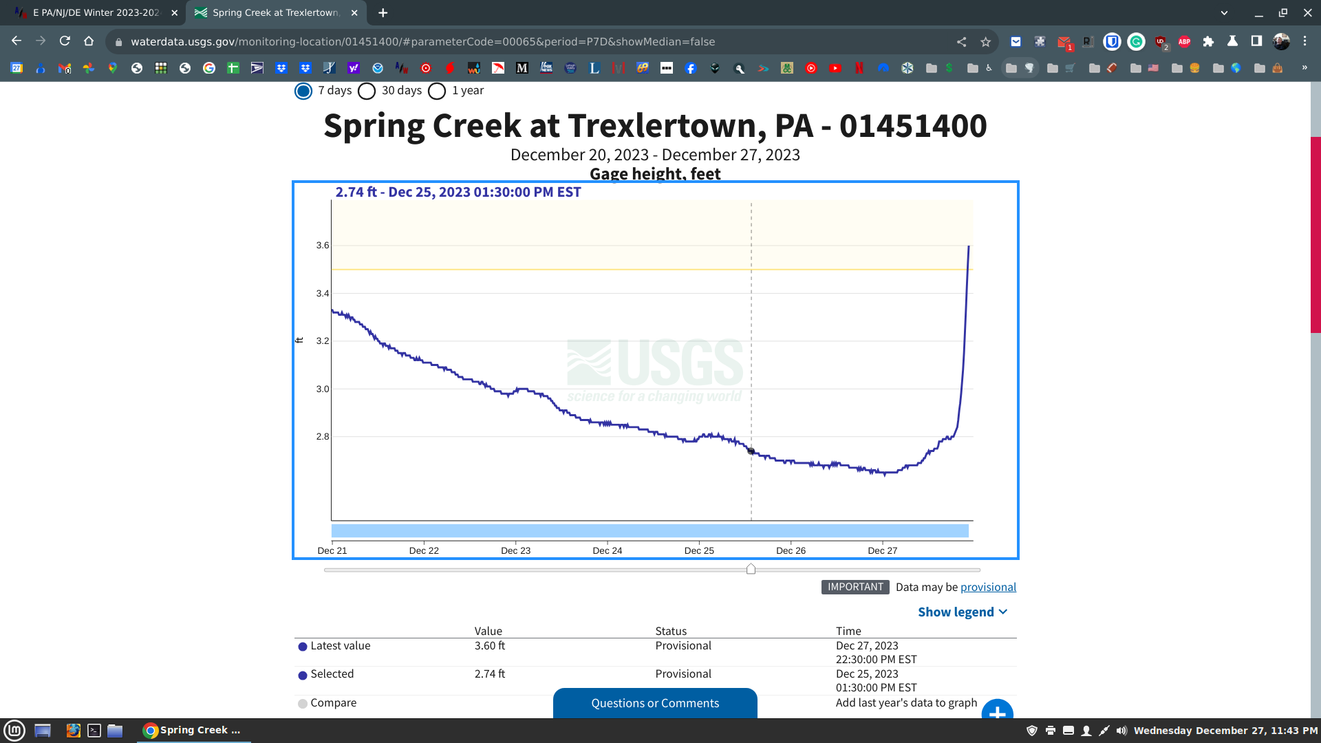
here in the lehigh Valley- have 2.5 inches in my gauge thus far-- flooding getting bad. ABE will destroy its all time record for total precip for the month of December tonight. Thats a huge headline. 9 inches is closing in for total rainfall for the month with much more at my house . I am hitting around 11 inches thus far at my house where the fire hose keeps coming at us
-
2.5 inches of rain thus far at my house near Allentown PA. Allentown is approaching 9 in of rain for the month smashing the all time record tonight Flooding really getting bad
-
E PA/NJ/DE Winter 2023-2024 OBS/Discussion
Albedoman replied to The Iceman's topic in Philadelphia Region
-
E PA/NJ/DE Winter 2023-2024 OBS/Discussion
Albedoman replied to The Iceman's topic in Philadelphia Region
the drought guy still here trying to stay dry. LOL So far 2.20 in of rain here in Ancient Oaks Macungie since 6pm. The row boats coming out again for the Little lehigh behind my house. Spring creek rd will be under water tomorrow morning. I expect Allentown LV will be in the news Heavy rain - the fire hose has been opened up for hours and it is still coming down hard -
E PA/NJ/DE Winter 2023-2024 OBS/Discussion
Albedoman replied to The Iceman's topic in Philadelphia Region
spoke too soon-- they did not wait until midnight Flood Warning National Weather Service Mount Holly NJ 912 PM EST Wed Dec 27 2023 DEC003-PAC011-017-029-045-077-091-095-280815- /O.NEW.KPHI.FA.W.0083.231228T0212Z-231228T0815Z/ /00000.0.ER.000000T0000Z.000000T0000Z.000000T0000Z.OO/ New Castle DE-Berks PA-Bucks PA-Chester PA-Delaware PA-Lehigh PA- Montgomery PA-Northampton PA- 912 PM EST Wed Dec 27 2023 ...FLOOD WARNING IN EFFECT UNTIL 315 AM EST THURSDAY... * WHAT...Flooding caused by excessive rainfall is expected. * WHERE...Portions of northern Delaware, including the following county, New Castle and Pennsylvania, including the following counties, Berks, Bucks, Chester, Delaware, Lehigh, Montgomery and Northampton. * WHEN...Until 315 AM EST Thursday. * IMPACTS...Flooding of rivers, creeks, streams, and other low-lying and flood-prone locations is imminent or occurring. * ADDITIONAL DETAILS... - At 910 PM EST, Doppler radar and automated rain gauges indicated heavy rain. Flooding is ongoing or expected to begin shortly in the warned area. Between 0.5 and 1.5 inches of rain have fallen. - Additional rainfall amounts of 0.5 to 1.5 inches are possible in the warned area. - Some locations that may experience flooding include... Allentown, Reading, Wilmington, Newark, Easton, Middletown, West Chester, Bethlehem, Norristown, Chester, Pottstown and Phoenixville. - http://www.weather.gov/safety/flood PRECAUTIONARY/PREPAREDNESS ACTIONS... Turn around...don`t drown when encountering flooded roads. Most flood deaths occur in vehicles. Be especially cautious at night when it is harder to recognize the dangers of flooding. && LAT...LON 4027 7607 4065 7597 4077 7569 4086 7529 4097 7512 4086 7505 4075 7520 4057 7519 3986 7534 3962 7559 3957 7554 3947 7557 3942 7553 3933 7576 3972 7579 3972 7614 3973 7609 3987 7599 4011 7594 4014 7587 -
E PA/NJ/DE Winter 2023-2024 OBS/Discussion
Albedoman replied to The Iceman's topic in Philadelphia Region
I can arrange that LMAO. Mt Holly decided this afternoon to leave out the LV in a flood watch. Just changed their tune real quick and has just issued one. I expect flood advisories to be issued for my neck of the woods by midnight. This is the most rain I have seen in 30+ years here in the LV in December. We will break the record. ABE rain gauge must have a hole in it if we do not break the record. LOL -
-
for those who are dejected and wishing to cancel winter based on the latest model runs do not fret ---- I am an historical meteorologist . You may ask what the hell is that? I rely on my personal weather pattern experiences over the last 50 years since I have been old enough to enjoy the knowledge of weather since I was 12 years old. I learned much weather from uncle who was the regional head forecasting meteorologist for NOAA (NWS) in the western US. I also was an air traffic controller in the Navy and graduated with a BS physical geography degree with a concentration in atmospheric science(Before many meteorological schools were even around). I do not rely solely LR daily model runs until the storms are within 48-72 hours period. Anything else is simply conjecture. I only rely on LR models to help establish the future temp/precip ranges and the possibilities of changes in the long term weather patterns. That is it. I was using my personal experiences and senses in the early 70's to 80's when there were no daily 8 hour model runs and the only models were spit out in a past weekly bulletin on the weeks previous storm events. I spent more time analyzing the storm patterns such as neutral, el nino and la nina patterns instead of relying just on LR computer model ensembles. Weather has been boiled down to a simple game of statistical chances by using computer model ensembles. Right or wrong, I side with past history Right now I see nothing but cold polar air bottled up in northern Canada with pacific cold fronts flowing zonally across the country Alberta Canada is where we get our cold air from except for an occasional backdoor cold front. There is nada coming from either direction right now. The southern jet stream is buckling but the northern stream will not come down into mid USA period to phase and deepen the lows. Until we get an LP over Alberta forming a clipper bringing that locked up polar air in Canada to the central US and introducing a potential pattern change, there is nothing we can do but watch models kick the potential 3-6 in snow events further into the 10-15 day time frame. WE must have sustainable cold- WE HAVE NONE. The potential of a 2-4 or 3-6 in snow event keeps showing up during the Jan 9-11 time frame but that is all it is. When I see it show up on the NAM at 36 hours- thats doable IMHO. My past personal history for those who believe in what I do, compares this year to 1993 where we had a crappy el nino winter 2-4 inches of snow until late February where we did get some accumulating snow event followed by the March superstorm which was a triple phaser. The el nino years below in a sample ranking chart . Please note 1958 has been thrown in the rankings for your forum too in February. (Morgantown blizzard) The winters are definitely back loaded for heavy snow sure in these years with some cold. It is just that we usually get cold sustainable cold in neutral years from the passage of continuous clippers as the el nino pattern is dying-- last gasp storm event before going into a neutral year. Remember how the severe cold in early 1994 set in that was attributable from weakening neutral year with the combination of MT Pinatubo eruption? We have not had a neutral winter in a long time. 3+ years. Lets see what the second to third week of January can throw at us? Ranked El Niño Events by 3-Month Season Rank DJF JFM FMA MAM AMJ MJJ JJA JAS ASO SON OND NDJ 1 1983 1983 1983 1983 1983 1997 1997 1997 1997 1997 1997 1997 2 1998 1998 1998 1998 1992 1983 1987 1987 1987 1982 1982 1982 3 1973 1992 1992 1992 1998 1992 1972 1972 1972 1972 1972 1972 4 1931 1931 1931 1987 1987 1987 1983 1982 1982 1987 1902 1930 5 1992 1973 1987 1941 1941 1941 1905 1905 1905 1902 1930 1965 6 1966 1919 1941 1931 1993 1993 1982 1902 1965 1930 1987 1902 7 1919 1987 1926 1926 1900 1900 1902 1965 1902 1965 1941* 1991 8 1926 1941 1958 1993 1997 1905 1941 1957 1930 1941 1965* 1941
-
for those who are dejected and wishing to cancel winter based on the latest model runs do not fret ---- I am an historical meteorologist . You may ask what the hell is that? I rely on my personal weather pattern experiences over the last 50 years since I have been old enough to enjoy the knowledge of weather since I was 12 years old. I learned much weather from uncle who was the regional head forecasting meteorologist for NOAA (NWS) in the western US. I also was an air traffic controller in the Navy and graduated with a BS physical geography degree with a concentration in atmospheric science(Before many meteorological schools were even around). I do not rely solely LR daily model runs until the storms are within 48-72 hours period. Anything else is simply conjecture. I only rely on LR models to help establish the future temp/precip ranges and the possibilities of changes in the long term weather patterns. That is it. I was using my personal experiences and senses in the early 70's to 80's when there were no daily 8 hour model runs and the only models were spit out in a past weekly bulletin on the weeks previous storm events. I spent more time analyzing the storm patterns such as neutral, el nino and la nina patterns instead of relying just on LR computer model ensembles. Weather has been boiled down to a simple game of statistical chances by using computer model ensembles. Right or wrong, I side with past history Right now I see nothing but cold polar air bottled up in northern Canada with pacific cold fronts flowing zonally across the country Alberta Canada is where we get our cold air from except for an occasional backdoor cold front. There is nada coming from either direction right now. The southern jet stream is buckling but the northern stream will not come down into mid USA period to phase and deepen the lows. Until we get an LP over Alberta forming a clipper bringing that locked up polar air in Canada to the central US and introducing a potential pattern change, there is nothing we can do but watch models kick the potential 3-6 in snow events further into the 10-15 day time frame. WE must have sustainable cold- WE HAVE NONE. The potential of a 2-4 or 3-6 in snow event keeps showing up during the Jan 9-11 time frame but that is all it is. When I see it show up on the NAM at 36 hours- thats doable IMHO. My past personal history for those who believe in what I do, compares this year to 1993 where we had a crappy el nino winter 2-4 inches of snow until late February where we di get some accumalting snow event followed by the March superstorm which was a triple phaser. The el nino years below in a sample ranking chart . Please note 1958 has been thrown in the rankings for your forum too in February. (Morgantown blizzard) The winters are definitely back loaded for heavy snow sure in these years with some cold. It is just that we usually get cold sustainable cold in neutral years from the passage of continuous clippers as the el nino pattern is dying-- last gasp storm event before going into a neutral year. Remember how the severe cold in early 1994 set in that was attributable from weakening neutral year with the combination of MT Pinatubo eruption? We have not had a neutral winter in a long time. 3+ years. Lets see what the second to third week of January can throw at us? Ranked El Niño Events by 3-Month Season Rank DJF JFM FMA MAM AMJ MJJ JJA JAS ASO SON OND NDJ 1 1983 1983 1983 1983 1983 1997 1997 1997 1997 1997 1997 1997 2 1998 1998 1998 1998 1992 1983 1987 1987 1987 1982 1982 1982 3 1973 1992 1992 1992 1998 1992 1972 1972 1972 1972 1972 1972 4 1931 1931 1931 1987 1987 1987 1983 1982 1982 1987 1902 1930 5 1992 1973 1987 1941 1941 1941 1905 1905 1905 1902 1930 1965 6 1966 1919 1941 1931 1993 1993 1982 1902 1965 1930 1987 1902 7 1919 1987 1926 1926 1900 1900 1902 1965 1902 1965 1941* 1991 8 1926 1941 1958 1993 1997 1905 1941 1957 1930 1941 1965* 1941
-
E PA/NJ/DE Winter 2023-2024 OBS/Discussion
Albedoman replied to The Iceman's topic in Philadelphia Region
Yes I have punted until about third week in January for a major snow event of 6+ inches for our area . The event on Jan 9-12 looks legitimate at this time if there is enough cold air in place over our area from a typical pacific cold frontal passage in place (ana frontal snow?) after a couple of days with an LP forming on the dragging cold front near the carolinas and is definitely not an alberta clipper that I was talking about. Any snow that accumulates will only be on the ground for a few days anyway but this could be a considered a legitimate snow event threat based based on the lack of snowfall in the last two years. We could see more snow from this single event than we got all last year so yes, I agree Ralph this potential snowfall event is is a threat no matter how little the accumulations are. 2-4 inches at the best as my first call if the event occurs. -
E PA/NJ/DE Winter 2023-2024 OBS/Discussion
Albedoman replied to The Iceman's topic in Philadelphia Region
wow, the record for rainfall in December for ABE is 7.89 inches in 1973. We should break the record by the end of the week. In Macungie I have had over 7.5 inches thus far this month with 2 to 3 inches expected by the end of the week. No drought here, thats for sure. The nasty part is that the groundwater table will be much higher than usual as the precip has been able to infiltrate into the ground with the ground remaining unfrozen. 1. Any runoff after one inch will be 100% runoff as the ground cannot take much more. Localized flooding will be a HUGE concern, especially in low spots such as closed depressions in our Karst geological areas with many ghost lakes appearing in farm fields and over roads 2. Sinkholes will be opening up everywhere. Here is one near my house in the Macungie area next to the road last week below from the the four plus inch rainfall event. The eye of the sinkhole went under the road 3. Flat road areas will pond water easily and freeze over. 4. Winter Springs will be popping up everywhere, leading to heavy ice accumulations on roads where underdrains are not located. Be careful. Literally dump truck loads of salt will be poured in these areas where the springs come up even in the middle of the roads as water will be flowing for weeks. One particular bad spot RT 63 in near Rt 563 near the ridge top will be bad with numerous potholes forming in the shale geology 5. Basements will have some major water issues thats for sure with sump pumps running full time. -
E PA/NJ/DE Winter 2023-2024 OBS/Discussion
Albedoman replied to The Iceman's topic in Philadelphia Region
I would love to be wrong but even a legit threat has no staying power. It will be gone in afew days. We have to have highs stay below the mid 20,s with no sun. No polar air anywhere -
E PA/NJ/DE Winter 2023-2024 OBS/Discussion
Albedoman replied to The Iceman's topic in Philadelphia Region
1. Cold air is in Northern Canada- locked uped for a while 2. Only a deep Alberta clipper will move out eh warm humid air now. When it comes is anyone's guess. When does come, watch out for major EC snowstorm following the passage 3. I agree. Thats why the upper midwest is baking right now 4. see statement two answer- a HECS event coming if the clipper hits us first 5. This our normal until the third week in January- thats when the pacific tuna fish can lid will be opened and the pac air goes bye bye to the far south - back into the GOM. Some say I am dead wrong- let the old timer prove them wrong. You can keep looking at those ensembles and analyze until the cows come home but the pattern will not change until we get a decent clipper passing over us period. From the historical weather forecaster we are a raity in this AI technology.