-
Posts
1,338 -
Joined
-
Last visited
Content Type
Profiles
Blogs
Forums
American Weather
Media Demo
Store
Gallery
Everything posted by Albedoman
-
E PA/NJ/DE Winter 2023-2024 OBS/Discussion
Albedoman replied to The Iceman's topic in Philadelphia Region
for those who do not know: 1. Winter storm warnings were issued for those areas where the 5 in snowfall criteria for issuing the warning has been met in the models. Unfortunately Montgomery/Bucks county were split down the middle with the existing WSW snowfall criteria levels for winter storm warnings. This is one scenario where me and the NOAA do not agree on. One inch snow accumulation difference in a metropolitan area of nearly 1-2 million people like the LV and northern Montgomery/Bucks county (more population than many states) does not make sense whatsoever . I hope they revise the winter weather advisories to WSW warnings and issue one for the northern Montgomery/Bucks county and the LV, especially since they calling for 8 in in the point forecast for Macungie PA and the criteria is 6 in. This is one storm I would err and be cautious about because of the higher snow ration and colder temps and blowing snow. There will be lots of accidents Friday night rush hour with drivers trying to beat the storm to ge to their destinations as many roads will be snow packed quickly 2. Blowing snow was also inserted into the forecast. Thank you Mt. Holly. This storm event will be discussed by all the posters and the media as being remembered for the blowing snow, frigid temps and lower visibilities and not just for high snow accumulations. This is the type of storm the old folks like me really remember of how winter should be and not just having the back breaking 20 inch snow events. Macungie point forecast Tonight A chance of snow, mainly after 3am. Cloudy, with a low around 23. Southwest wind around 5 mph becoming calm in the evening. Chance of precipitation is 40%. Total nighttime snow accumulation of less than a half inch possible. Friday Snow. High near 28. Northeast wind around 5 mph. Chance of precipitation is 100%. New snow accumulation of 3 to 7 inches possible. Friday Night A chance of snow, mainly before 10pm. Cloudy during the early evening, then gradual clearing, with a low around 12. Wind chill values as low as zero. Northwest wind 5 to 15 mph. Chance of precipitation is 30%. New snow accumulation of less than one inch possible. Saturday Areas of blowing snow. Mostly cloudy, with a high near 21. Wind chill values as low as -1. Blustery, with a northwest wind 10 to 20 mph, with gusts as high as 35 mph. Saturday Night Areas of blowing snow. Mostly cloudy, with a low around 13. Blustery, with a northwest wind 15 to 20 mph. Sunday Sunny, with a high near 27. Blustery. -

E PA/NJ/DE Winter 2023-2024 OBS/Discussion
Albedoman replied to The Iceman's topic in Philadelphia Region
sorry, Mike my age is showing. The current winter weather advisory should be continued into Saturday morning based on perhaps satisfying part of this criteria below Blowing snow advisory (WSW) – Sustained winds or frequent gusts of 25 to 35 miles per hour (40 to 56 km/h) accompanied by falling and blowing snow, occasionally reducing visibilities to 1⁄4 mile (0.40 km) or less, will occur for at least three hours. Discontinued beginning with the 2008-2009 winter storm season and replaced by the Winter Weather Advisory for Blowing Snow.[24] If the criteria is not meant, then a special hazardous statement maybe issued similar to when there is black ice.. Anyway, blowing snow will be an issue in the rural areas. Its been a real long time - before 2009 - since we have had this type of weather with high snow ratios and winds together and drivers will not be used to it thats for sure too. -

E PA/NJ/DE Winter 2023-2024 OBS/Discussion
Albedoman replied to The Iceman's topic in Philadelphia Region
Said this yesterday: this model indicates near 5.5 inches for my location. I say bring it on. LMAO . But folks its not the snow amounts that interest me at this time. For the first time in at least five years or more, we will have what I call the 3F's 1. fluffy high ratio snows, 2. frigid temps and 3. frequent gusts of high winds near 35 mph. The 3F's will produce a pretty good amount blowing of snow and drifting on local flat and or steep roads, especially in the countryside. As soon as the plows open them up, they will be be clogged again within a few hours with drifting snow. Now thats a real winter to me. Mt Holly has not included blowing snow in their forecasts this evening. That is troublesome to me but I expect them to issue a special statement on the blowing snow scenario for Saturday by Friday afternoon Cannot wait for the blowing snow statement- just as good as a winter storm warning- Eye candy -

E PA/NJ/DE Winter 2023-2024 OBS/Discussion
Albedoman replied to The Iceman's topic in Philadelphia Region
this model indicates near 5.5 inches for my location. I say bring it on. LMAO . But folks its not the snow amounts that interest me at this time. For the first time in at least five years or more, we will have what I call the 3F's 1. fluffy high ratio snows, 2. frigid temps and 3. frequent gusts of high winds near 35 mph. The 3F's will produce a pretty good amount blowing of snow and drifting on local flat and or steep roads, especially in the countryside. As soon as the plows open them up, they will be be clogged again within a few hours with drifting snow. Now thats a real winter to me. Mt Holly has not included blowing snow in their forecasts this evening. That is troublesome to me but I expect them to issue a special statement on the blowing snow scenario for Saturday by Friday afternoon -

E PA/NJ/DE Winter 2023-2024 OBS/Discussion
Albedoman replied to The Iceman's topic in Philadelphia Region
Just what the pixie fairy called for good grief. Throw a tooth under the pillow too -

E PA/NJ/DE Winter 2023-2024 OBS/Discussion
Albedoman replied to The Iceman's topic in Philadelphia Region
why anyone would be looking at global models for tonights snow totals is a definite snow weenie. The NAM , RGEM and HRRR thats it baby. There needs to be a blend of all these models for SR forecasting of snow totals within 36 hours of the event, Then many people can hype that instead of whats on the LR -

E PA/NJ/DE Winter 2023-2024 OBS/Discussion
Albedoman replied to The Iceman's topic in Philadelphia Region
what will it take to make you happy- two back to back SECS? Let those who are starved to see a real winter of a white ground and lows near ten degrees for longer than 48 hours in the last three years enjoy their two inches from this snow event for the next week or so. I am so tired of seeing 3-6 in snows be gone in less than three days. What a waste of a good snowpack. By the way this so called lousy 2-4 in snow event will save the ski resorts this year and give snow removal companies some money. These individuals need this pixie dust and pity flakes more than you anyway LOL -

E PA/NJ/DE Winter 2023-2024 OBS/Discussion
Albedoman replied to The Iceman's topic in Philadelphia Region
Friday event is icing on the cake snow event for Tuesday and not an issue as long it is not another 2 inch rain event. My motto with this event -- SCOGFAM -----snow cover our ground for a month SC method -

E PA/NJ/DE Winter 2023-2024 OBS/Discussion
Albedoman replied to The Iceman's topic in Philadelphia Region
even though the squall Sunday is not a true clipper, it maybe enough to break the crappy pattern ushering in the arctic air with a strong cold front , even for a week. The models are coming back with the snow this morning for Tuesday too. Not a foot but a moderate snowfall I expect 2-4 or 4-6 would be in line. The best part of all this, we get snow on the ground for longer than 3 days and lows near the single digits Now thats winter too me. I said around the third week? So I am off a few days. I said this a month ago. We take -
I just want a 12 in snow pack on the ground for 2 weeks with lows in the single digits and teens. Dam, when did that happen last in the valleys?
-

E PA/NJ/DE Winter 2023-2024 OBS/Discussion
Albedoman replied to The Iceman's topic in Philadelphia Region
About 13 inches of rain for many areas in our forecast region IN 30 DAYS IS NOT NORMAL, especially in DEC - JAN. That is over 30% of annual precipitation on semi frozen with little or no evapotranspiration on saturated grounds in less than 8 weeks. Completely different scenario than a summer tropical storm event. I have the absolute right to flip out a little as this crappy rainy weather pattern has never been experienced by the majority of us in our lifetime including me solely in the winter months. 2011 was the last time we had 13 or more inches of rain in any two consecutive months - back to back tropical storms Irene and Lee in August and Septemeber https://www.extremeweatherwatch.com/cities/allentown/most-monthly-precipitation. You are now enjoying something that has never been seen in over 125 years of weather recorded history. That is 100 times more interesting than tracking a dam snow storm to a weather buff. The stupid media not picking up on this weather history situation is beyond me. -

E PA/NJ/DE Winter 2023-2024 OBS/Discussion
Albedoman replied to The Iceman's topic in Philadelphia Region
better late than never LOL. No more flooding rains hopefully. -
the pac buoy info is being ingested into the models the last two days. That will not be the case after tomorrow night. Everyone calm down. The snow will come. Once the buoy info is gone and the LP is positioned in Canada, the location of the LP along the coast will be clearly defined.
- 1,593 replies
-

E PA/NJ/DE Winter 2023-2024 OBS/Discussion
Albedoman replied to The Iceman's topic in Philadelphia Region
hell no I will not flip out. 1-2 inch rain is nothing now. a cakewalk. The major sewer lines in our area are fully surcharged and overflows are occuring from inflow from leaky pipes. This does not bode well for the municipalities of the Lehigh County. The township people today pulled the sewer lid out in front of my house and the pipe was full and it was not blocked after they jetted the collector line. Can you say the shit has already hit the fan with these rainfall amounts in the last 30 days? Bring on the cold and snow , I am ready -
Walt, if we can get a decent cutter to come across that polar air in the midwest and drag it over the Appalachians, we are in the game for some decent and memorable snowfall events after next Tuesday. Many posters either do not remember 96 or were not alive but I sure the hell do. It only takes one good cutter with a deep trough and an -NAO to phase LP's some good storms along the east coast. We just need some of that polar air to get the engine fine tuned. That polar air locked in the midwest and Ohio Valley IMHO next week transferring just a few days over to us by a clipper would be like putting is like putting Sea Foam in your V8 carburetor. LOL
-

E PA/NJ/DE Winter 2023-2024 OBS/Discussion
Albedoman replied to The Iceman's topic in Philadelphia Region
The drought guy here saying any chance of drought now will not return until late summer at the earliest. Personally if I see another 2-3 inch rainfall event after Saturday, I give up on winter LOL. I have measured nearly 15 inches of rain in less than 30 days at my domain. To put that in perspective, that is almost 35% of our annual total rainfall in just 30 days with little to no evapotranspiration. That is 100% recharge into the aquifers with unfrozen soils and what does not recharge is 100% runoff. All wells are at max levels and all impoundments for public water supply our at max for our area too. Any snow we get is a real plus now. Spring growth should be fantastic this year with blooming flowers along with those who love to mow because the of all the free nitrogen in the rainfall. The grass will be very green in Late March. I said in earlier posts that the third week of January (21st) would be the trigger. I am real close. The snow conveyor belt is about to begin as cold air is trying is dam hard to blow over the appalachians mountains by the middle part of next week. If a clipper shoots down in our direction, we will get some of that polar air too to set up the parade of storms as the GOM is finally opening its doors after a 5+ year hiatus . Lets cross our fingers. -

E PA/NJ/DE Winter 2023-2024 OBS/Discussion
Albedoman replied to The Iceman's topic in Philadelphia Region
actually as legitimate snow weenie LOL, I am pretty pissed tonight that Memphis TN will experience a true winter on MLK way before us. What do I mean? The highs on Monday will be in the teens with snow 2-3 inches in memphis. Not alot of snow but dammit, the ratios will be so high with the extreme cold temps and it will be on the ground for days. What really gets me cranking as their overnight lows will be near zero on Monday night. Please make this f*&king rain go away. 15 inches of rain in less than 30 days enough. -

Two Mdt to high impact events NYC subforum; wknd Jan 6-7 Incl OBS, and mid week Jan 9-10 (incl OBS). Total water equiv by 00z/11 general 2", possibly 6" includes snow-ice mainly interior. RVR flood potential increases Jan 10 and beyond. Damaging wind.
Albedoman replied to wdrag's topic in New York City Metro
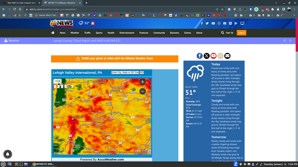
first of several squall lines forming.Expect 50 mph gusts any time here in the LV. approaching 2 inches of rain now. The fire hydrant is opened full wide at my house in Macungie- 3,610 replies
-
- snow
- heavy rain
- (and 5 more)
-

Two Mdt to high impact events NYC subforum; wknd Jan 6-7 Incl OBS, and mid week Jan 9-10 (incl OBS). Total water equiv by 00z/11 general 2", possibly 6" includes snow-ice mainly interior. RVR flood potential increases Jan 10 and beyond. Damaging wind.
Albedoman replied to wdrag's topic in New York City Metro
thanks- 3,610 replies
-
- snow
- heavy rain
- (and 5 more)
-

Two Mdt to high impact events NYC subforum; wknd Jan 6-7 Incl OBS, and mid week Jan 9-10 (incl OBS). Total water equiv by 00z/11 general 2", possibly 6" includes snow-ice mainly interior. RVR flood potential increases Jan 10 and beyond. Damaging wind.
Albedoman replied to wdrag's topic in New York City Metro
University of Memphis 1979-1986 Awarded B.S. Degree in Physical Geography with an Environmental Science Concentration and a Geology Minor in 1981. Obtained post-graduate experience in Environmental and Urban Planning Resource Management from 1984 to 1986. Highlights - Masters of Fellowship Award-only awarded to one graduate student in all 17 graduate schools-twice awarded for independent research and high GPA average. President of Gamma Theta Upsilon National Honor Society in 1981. Deans List awarded-1981. Technical Background - Air/Remote Sensing, Quantitative Analysis, GIS Systems, Water Quality Analysis, including Hydrogeological Studies, and Urban Land Use Studies.- 3,610 replies
-
- snow
- heavy rain
- (and 5 more)
-

Two Mdt to high impact events NYC subforum; wknd Jan 6-7 Incl OBS, and mid week Jan 9-10 (incl OBS). Total water equiv by 00z/11 general 2", possibly 6" includes snow-ice mainly interior. RVR flood potential increases Jan 10 and beyond. Damaging wind.
Albedoman replied to wdrag's topic in New York City Metro
this map says it all. Notice the precip over the Poconos/LV. The snowpack will not hold in the precip, its already saturated enough now. The Delaware River will rise ten feet or more in less than 6 hours on Wednesday morning. The tributaries like the Lehigh River will make the flooding even worse as the snow pack will be completely erased. Little or no sublimation will take place as a result of this type of snowmelt. Fog would have really helped us out but the warm SE winds will melt the crap out the snow before evaporation can take place. IMHO, that is a major game changer because several times during a winter season, a good fog will slowly destroy a snow pack. This time no such luck. The soil profile horizons are supersaturated completely from the A Horizon all the way to the C horizons. Springs are really flowing heavily right now (Shale soils especially) as the ground is frozen only a few inches and not in feet like it should be. I expect major flooding. Anyone doubt me, I am a NRCS certified hydrologist. Simply stated, there is no room from water to be stored- its all going to runoff. Better get your waders on.- 3,610 replies
-
- 1
-

-
- snow
- heavy rain
- (and 5 more)
-

Two Mdt to high impact events NYC subforum; wknd Jan 6-7 Incl OBS, and mid week Jan 9-10 (incl OBS). Total water equiv by 00z/11 general 2", possibly 6" includes snow-ice mainly interior. RVR flood potential increases Jan 10 and beyond. Damaging wind.
Albedoman replied to wdrag's topic in New York City Metro
The idea of a gravity wave Walt is exactly what I was thinking as well. Mixing the winds down through a squall line will yield a tremendous amount of straight line wind damage, especially for those on ridges, hills and deep valleys. The second storm this week on Sat is very concerning as well as their will be absolutely no more stormwater storage in manmade structures and in the soils and anything that falls will be 100% runoff to the rivers. Even a 1.5 in of rain event will be create serious flooding. Another thread should be created for this storm event after Wednesday. The mid atlantic region is experiencing its own atmospheric river right now and the media should be picking up on this fact. Never in my lifetime have I seen so many 2-3+ in rain events occur in less than a month and especially in December and January for our area. If the artic cold was present at each event, we would be talking nearly 100 inches of snow for our region already.- 3,610 replies
-
- 1
-

-
- snow
- heavy rain
- (and 5 more)
-

Two Mdt to high impact events NYC subforum; wknd Jan 6-7 Incl OBS, and mid week Jan 9-10 (incl OBS). Total water equiv by 00z/11 general 2", possibly 6" includes snow-ice mainly interior. RVR flood potential increases Jan 10 and beyond. Damaging wind.
Albedoman replied to wdrag's topic in New York City Metro
Walt, I am at a loss. Many posters have no clue what will be upon them Wed morning. 45-60 mph winds with 3-4 inches of rain over a 6-12+ inch snow pack in NE and EPA/NJ. I really hope the flooding is curtailed but I have never seen the ground as saturated as it is right now in my 45 years living in the NE US. Posters discussing about 1- 2 inch snows in the major cities will be the least of their worries. I will make the same comparison as this storm being like Issac but not quite as bad as Sandy. I am sure they all remember those storms. The big difference will be the high sustainable SE winds over super supersaturated soils causing wind thrown trees everywhere. The trees are not used to blowing in that direction in the winter, thus their root structure is susceptible to be pulled out of the ground easily too. You add all the diseased ash trees weakened over the last few years from the ash borer in eastern PA and NJ and you have one hell of a down tree problem. Furthermore, the stormwater basins will not absorb any water as they do in the summer as the soils in these basins are clay lined/semi frozen and saturated so they will fill quickly and runoff into the creeks and rivers quickly too. Totally different stormwater reactions and output from a typical summer storm. This storm event might as well be considered a tropical winter storm event that has the possibility of t- storms with straight line wind squall lines and if you add the existing snow melt on saturated grounds will be like receiving 5-6+ inches of rain in a tropical storm. As I said before, this event may not reach the magnitude of the flood of 96, but it will be close. I am not trying be a debbie downer but a realist. This scenario unfolding is not a joking matter over who gets the most snow. The media should be playing this situation up not worrying when the snow plow comes by your street. Its a shame because I will see many posters post how bad the flooding will be on Wednesday . I just hope they get prepared.- 3,610 replies
-
- 6
-

-

-
- snow
- heavy rain
- (and 5 more)
-

Two Mdt to high impact events NYC subforum; wknd Jan 6-7 Incl OBS, and mid week Jan 9-10 (incl OBS). Total water equiv by 00z/11 general 2", possibly 6" includes snow-ice mainly interior. RVR flood potential increases Jan 10 and beyond. Damaging wind.
Albedoman replied to wdrag's topic in New York City Metro
we had 5-8 in here in the Lehigh valley in most places. All I can say is that if you try to shovel this stuff, it is super wet. My snow thrower was having troubling handling it. I see many having heart issues if they try to shovel this stuff in the morning. Its like shoveling pure slush. The snow ratio had to be less than 6:1. I have not seen this wet of a snow in five years here. The flakes were pancakes coming down for a few hours. Oh how I dread Tuesday night as the soils are now super saturated and not frozen. Wind thrown trees and huge flooding problems coming our way for sure from this tropical like storm in January. Instability in the soundings talking some thunder too on Tuesday night The water content in tonight's storm event of 6 inches of snow has to be at least one inch or more. Add that to the potential of 2-3+ inches of expected rain and we have record flooding.- 3,610 replies
-
- snow
- heavy rain
- (and 5 more)
-
Yes yesterday or on Thursday I said they should post winter storm warnings for the LV. I have over 6 inches IMBY here in Macungie. Guess what, as usual, they issue a winter storm warning just now. Too late to stop people from clogging up the roads with accidents but whatever. URGENT - WINTER WEATHER MESSAGE National Weather Service Mount Holly NJ 822 PM EST Sat Jan 6 2024 PAZ061-062-071100- /O.UPG.KPHI.WW.Y.0001.000000T0000Z-240107T1100Z/ /O.EXB.KPHI.WS.W.0001.000000T0000Z-240107T1100Z/ Lehigh-Northampton- Including the cities of Allentown, Bethlehem, and Easton 822 PM EST Sat Jan 6 2024 ...WINTER STORM WARNING IN EFFECT UNTIL 6 AM EST SUNDAY... * WHAT...Heavy wet snow. Additional snow accumulations of up to 3 inches. Winds gusting as high as 35 mph. * WHERE...Lehigh and Northampton. * WHEN...Until 6 AM EST Sunday. * IMPACTS...Travel could be very difficult. * ADDITIONAL DETAILS...The heaviest accumulations will be in northern and western parts of the counties across the higher elevations. PRECAUTIONARY/PREPAREDNESS ACTIONS... If you must travel, keep an extra flashlight, food, and water in your vehicle in case of an emergency. The latest road conditions for the state you are calling from can be obtained by calling 5 1 1.


