Albedoman
-
Posts
1,379 -
Joined
-
Last visited
Content Type
Profiles
Blogs
Forums
American Weather
Media Demo
Store
Gallery
Everything posted by Albedoman
-

E PA/NJ/DE Autumn 2025 Obs/Discussion
Albedoman replied to PhiEaglesfan712's topic in Philadelphia Region
now it is showing up on tonights run. First flakes of the year?
-
E PA/NJ/DE Autumn 2025 Obs/Discussion
Albedoman replied to PhiEaglesfan712's topic in Philadelphia Region
noon runs look like an overunning situation possibly forming after a cold frontal passage near 11/13 with cold enuf temps to have frozen precip. Something to watch. The cold frontal passage on the 10th will bring hard freezes with temps in low 20's and high in the upper 30's. -
E PA/NJ/DE Autumn 2025 Obs/Discussion
Albedoman replied to PhiEaglesfan712's topic in Philadelphia Region
All I know is this scenario model run better not happen. After looking at the CMC noon run, this would make Sandy look like a baby. With all of the dead ash trees in Eastern PA now and especially in the LV and urbanized and major riverine flooding, this would be a one hell of a disaster for our area. I would see unbelievable debris dams in the waterways from these fallen limbs and trees that would wipe out major bridges in our area. The power outages would be unmanageable and you will not find a generator in stock for 250 miles from our region. The fact this scenario is already showing up for one week away warrants further discussion by all pro's. Even a slight hit would be a huge concern. There will nothing left at the NJ beaches for next year beaachgoers and NYC will get one hell of test of its new subway drainage pumping system. Definitely will keep an eye on these model runs as the media and so-called internet weather gurus on facebook/youtube will play this up real good in the next few days if the the model runs continue to show this tonight and tomorrow. Can you say Panic? -
E PA/NJ/DE Autumn 2025 Obs/Discussion
Albedoman replied to PhiEaglesfan712's topic in Philadelphia Region
Just had a thundershower- light ---here in lower macungie -
E PA/NJ/DE Autumn 2025 Obs/Discussion
Albedoman replied to PhiEaglesfan712's topic in Philadelphia Region
My forecast did suggest a slow start. Enjoy the fall weather while you can. Come january you will be wishing for temps above 45 . I expect more mix events than anything else in late nov into mid dec as the pattern sets up for january -
E PA/NJ/DE Autumn 2025 Obs/Discussion
Albedoman replied to PhiEaglesfan712's topic in Philadelphia Region
sorry, I was not living here in PA at the time so I never experienced what was going on. I was down in Memphis Tn at the time. I had other hurricanes to deal with down there at the time Elena but more importantly, Memphis had over a foot of snow in one storm in the winter of 85 . That would be like a 3 ft snow here. -
E PA/NJ/DE Autumn 2025 Obs/Discussion
Albedoman replied to PhiEaglesfan712's topic in Philadelphia Region
Million dollar t storms right now -
E PA/NJ/DE Autumn 2025 Obs/Discussion
Albedoman replied to PhiEaglesfan712's topic in Philadelphia Region
Drenching downpours are coming in the next two days says the drought guy. Million dollar rains for landscapers and for fall colors -
E PA/NJ/DE Autumn 2025 Obs/Discussion
Albedoman replied to PhiEaglesfan712's topic in Philadelphia Region
I am not too worried yet. Its dry like this on average years during this time frame. Concerns: 1. Being a neutral year, we are in for a real cold and snowy winter which will definitely help the groundwater tables. See lots of northeaster's and the potential freezing rain/sleet events early in December. Expecting some nice rains by mid October as the warm pattern breaks down. A good tropical storm up the east coast can really help get us out this stubborn pattern. 2. The leaves are scorched brown and falling off. No color until we have temps in the 40's again and highs only in the low 60's. Do not see that happening until the second week of October folks. 3. I agree. We need some decent rain by Wednesday, otherwise burn bans will likely go into effect in the next week or so. The canopies are dry and the scorched leaves falling are not helping. 4. Even the tent caterpillars died off in this early warm spell before autumn. This is been the latest I have run the AC in a real long time as overnight lows struggle to get to the 50's -
E PA/NJ/DE Autumn 2025 Obs/Discussion
Albedoman replied to PhiEaglesfan712's topic in Philadelphia Region
what are talking about? The drought ended back in July for the LV. Hell, I had 2.5 in of rain two days ago at my house. I would be more worried about us having a neutral winter this year and record cold come mid December . Enjoy your Halloween as the frigid air will come back near Thanksgiving this winter with more nor'easter chances. -
E PA/NJ/DE Summer 2025 Obs/Discussion
Albedoman replied to Hurricane Agnes's topic in Philadelphia Region
2.15 inches at house in LMT= still raining -
E PA/NJ/DE Autumn 2025 Obs/Discussion
Albedoman replied to PhiEaglesfan712's topic in Philadelphia Region
Getting hammered. Best t storms in a long time. Lighting hitting homes in our area. Thunder shaking the whole house. Picked up nearly an inch so far. This rain helped the corn and soybean yields -
E PA/NJ/DE Summer 2025 Obs/Discussion
Albedoman replied to Hurricane Agnes's topic in Philadelphia Region
1.25 at my house. Nice steady downpours tonight. There is no drought now with over 3.5 in the past week. The soybeans are the greenest I have seen them in a long time. Dewpoints in the 40's will be welcomed- more evening fires in the fire pit. -
E PA/NJ/DE Summer 2025 Obs/Discussion
Albedoman replied to Hurricane Agnes's topic in Philadelphia Region
https://www.mcall.com/2025/08/13/severe-storms-lehigh-valley-power-outages/ -
E PA/NJ/DE Summer 2025 Obs/Discussion
Albedoman replied to Hurricane Agnes's topic in Philadelphia Region
2.45 in of rain thus far. Million dollar rain for the spike corned -
E PA/NJ/DE Summer 2025 Obs/Discussion
Albedoman replied to Hurricane Agnes's topic in Philadelphia Region
holy snikes. I am getting shit kicked out of me as far as downpours.go. It is raining at a full 2 inches+ an hour here in lower macungie at 4:45 pm. Flash flood warnings will be issued soon. -
E PA/NJ/DE Summer 2025 Obs/Discussion
Albedoman replied to Hurricane Agnes's topic in Philadelphia Region
I am still waiting for a winter storm warning event LOL. You know its dry when another sinkhole opens up a 100 ft wide crater right across the street from the Amazon Center in Palmer Township. The hurricane in a few weeks will take care of any drought conditions. Planting grass seed is impossible in these conditions. This is seal your driveway or paint the fence weather dry and hot. -
E PA/NJ/DE Summer 2025 Obs/Discussion
Albedoman replied to Hurricane Agnes's topic in Philadelphia Region
Drought guy says cmon baby. Only a major hurricane riding up the coast will be our savior. The corn is already spiking in western lehigh county. Everone else east of s mountain got inches of rain as we got zilch .....lots of complaints about turning off the normal rain pattern in july. This what you get brown lawns everwhere here in lower macungie. We have been the screw zone since mid july. -
E PA/NJ/DE Spring 2025 Obs/Discussion
Albedoman replied to PhiEaglesfan712's topic in Philadelphia Region
Mike Gorse, fwiw,--the current point forecast for Ancient Oaks in Lehigh County does not display the current flood warning- strangeIt maybe because Its for Perkiomen stream only and not the Little lehigh. I guess Thanks -
E PA/NJ/DE Spring 2025 Obs/Discussion
Albedoman replied to PhiEaglesfan712's topic in Philadelphia Region
https://water.noaa.gov/gauges/trep1 -
E PA/NJ/DE Spring 2025 Obs/Discussion
Albedoman replied to PhiEaglesfan712's topic in Philadelphia Region
2.25 inches of rain at my house - Spring Creek is at flood stage and rising quickly. Been a long time since we have reached flood stage. Yes I will declare this drought over guys at this time. These long duration rains are now bringing up the base flows of the streams. Corn is coming up nicely in my area of Lehigh County. If the farmer is trying to plant it now, it could be a loss. The loss however is not just the rain but with the extreme cooler temps. Usually by now, we have temps in the mid to upper 80's with a few days of 90's. In fact, we maybe back in the 40's for overnight lows and highs only in the upper 60's for June 1 ------ Coolest I have seen for us in June but it does save on the AC bills. But after Wednesday, we go back into the oven. Watch the mold counts grow big time. -
E PA/NJ/DE Spring 2025 Obs/Discussion
Albedoman replied to PhiEaglesfan712's topic in Philadelphia Region
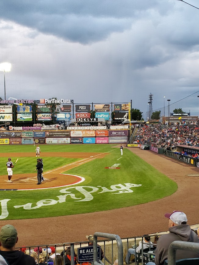
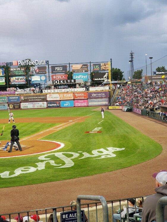
I attended the Iron Pigs game last night. Cold unstable air mass showers popping up throughout the game. Observed three rainbows with one of them being a double rainbow. However, if you look directly over the US foods advertising board, in these photos in right field, there appears to be a cold air funnel forming with the cold unstable air mass in place. I would like Mike and his team to look at these photos for verification. It did not appear to be a simple rain shaft but actually appeared to have rotation and looked like a funnel. If this was indeed a cold air funnel, this would be extreme for our area but I would not doubt its formation with this very cold unstable air mass above in late May.
-
E PA/NJ/DE Spring 2025 Obs/Discussion
Albedoman replied to PhiEaglesfan712's topic in Philadelphia Region
LMAO- Guess its time to change my alias to flood guy now -
E PA/NJ/DE Spring 2025 Obs/Discussion
Albedoman replied to PhiEaglesfan712's topic in Philadelphia Region
Thanks Mike I should have said "possible" left out the word. Sorry. It appears to be an EF0 after looking at the tree damage video more closely but FWIW to shear of tree tops and twist them like that would have easily destroyed a home if the funnel actually reached the ground and was not over a forested area, which why I said a possible EFI . -
E PA/NJ/DE Spring 2025 Obs/Discussion
Albedoman replied to PhiEaglesfan712's topic in Philadelphia Region
well even though Macungie got zilcho rain from this storm, Bangor area in Northampton County got hail and an EF1 tornado that was on video. Tree tops sheared right off and twisted (not straight line wind damage) and no doubt that it was a tornado with hail from this very localized supercell -should have chased that one down. Mt holly storm damage specialists I am sure will out there to inspect tomorrow. https://www.wfmz.com/weather/it-took-out-almost-every-tree-on-my-property-tornado-touches-down-in-northampton-county/article_8f50d7e4-d6a2-4ae0-9709-dd23a3a73bc7.html#tncms-source=More-from-newsroom-(right-column)