Newman
-
Posts
2,484 -
Joined
-
Last visited
Content Type
Profiles
Blogs
Forums
American Weather
Media Demo
Store
Gallery
Everything posted by Newman
-

Central PA Winter 2022/2023
Newman replied to Blizzard of 93's topic in Upstate New York/Pennsylvania
I actually just checked Parker Dam, cheap cabins so will consider it -
Central PA Winter 2022/2023
Newman replied to Blizzard of 93's topic in Upstate New York/Pennsylvania
Having serious thoughts of "chasing" this storm out there in central PA, lots of similarities to Dec 1992. Anybody know of any good State Parks I could rent a cabin at in that general area of Blair and Clearfield counties? -
Central PA Winter 2022/2023
Newman replied to Blizzard of 93's topic in Upstate New York/Pennsylvania
Euro is HUGE for much of central PA, west of the river -
Latest CIPS analog guidance no surprise has Dec 1992 as the #1 analog It's interesting to note the slightly further west NAO blocking we have this time around compared to 1992 (sitting squarely over the Hudson Bay on the 12z GFS, compared to east of it). Will that make a difference?

-
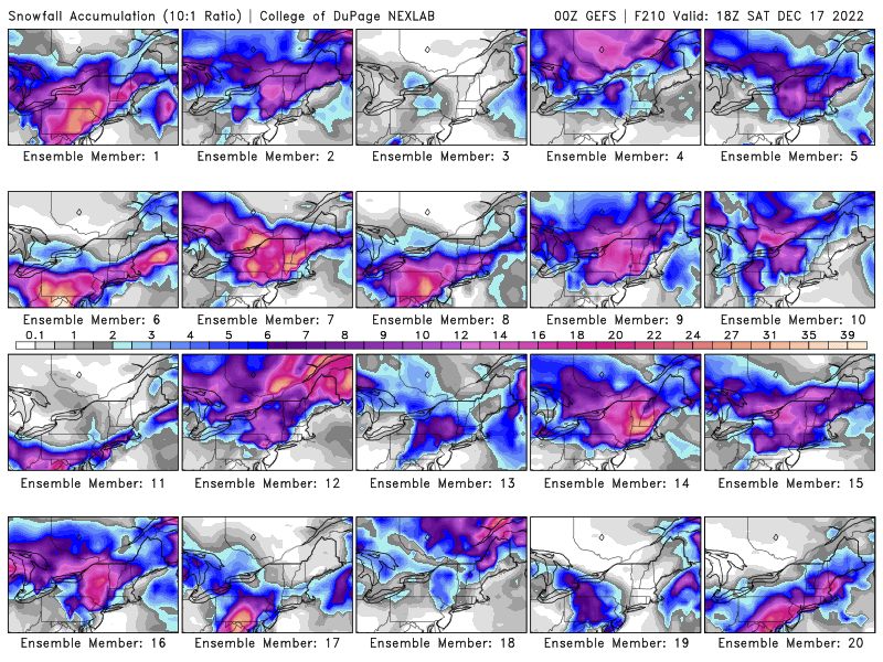
6z GEFS... look at member 14. Right now the GEFS are catching back up to the other guidance, so not as many hits. But there are still quite a few solid hits
-
Central PA Winter 2022/2023
Newman replied to Blizzard of 93's topic in Upstate New York/Pennsylvania
0z GEFS showing some pretty big hits
-
There's some pretty big solutions showing up on the GEFS, especially for the interior but even some for the coast
-
Central PA Winter 2022/2023
Newman replied to Blizzard of 93's topic in Upstate New York/Pennsylvania
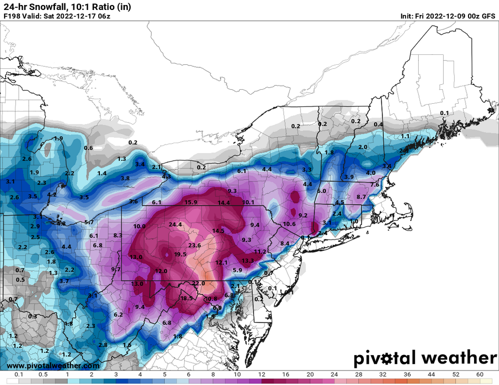
0z GFS with an absolute crusher next weekend. I really like Central PA's prospects for next weekend. Big cutter in the plains gonna get forced under the block and reform off the coast. Lots of cold air.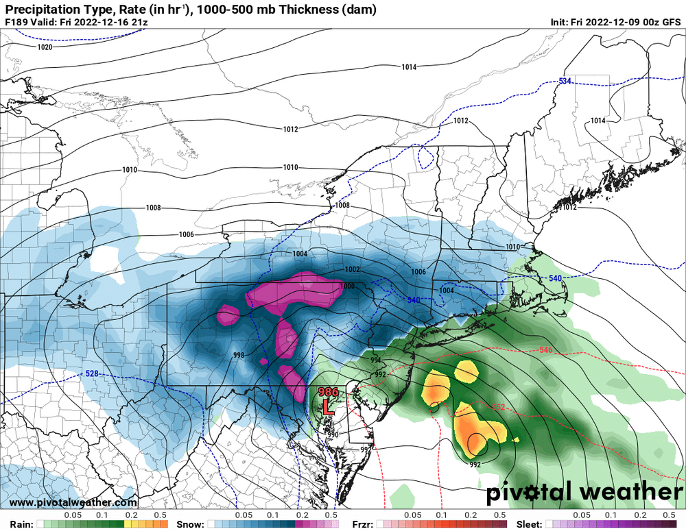
-
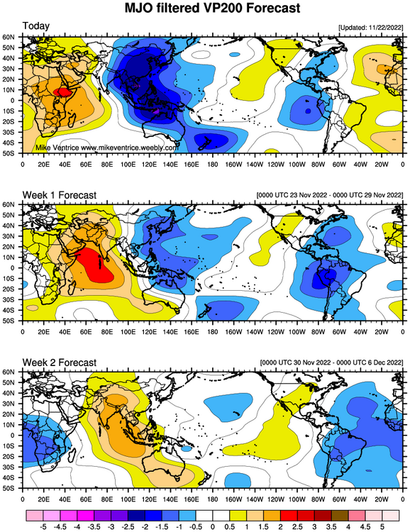
I would agree with you and John that we will likely need to wait until mid-December to see snow chances. However, what I don't like heading into the winter is the persistent convection in MJO 5-7(which aren't the ideal phases for EC snow chances). You can see it on the OLR maps and the Velocity Potential time series which I'll attach here as a link: (https://www.cpc.ncep.noaa.gov/products/precip/CWlink/ir_anim_monthly.shtml#:~:text=Velocity potential anomalies are proportional,to be enhanced (suppressed).) With the Pacific modeled in the long range, it by itself will not produce wintry weather. However, the high latitude blocking and potential for a ridge bridge in the long range is encouraging, and will be necessary, if we don't push the Aleutians ridge into the PNA region.
-
- 852 replies
-
- 1
-

-
- hurricane
- tropical storm
- (and 1 more)
-
Record low max forecast at KRDG tomorrow. NWS forecast is 34, current record is 35 from 1951
- 852 replies
-
- 1
-
-
- hurricane
- tropical storm
- (and 1 more)
-
I think some of the higher elevations NW will see their first snow this week. Probably non-accumulating in most areas
- 852 replies
-
- 2
-
-

-
- hurricane
- tropical storm
- (and 1 more)
-
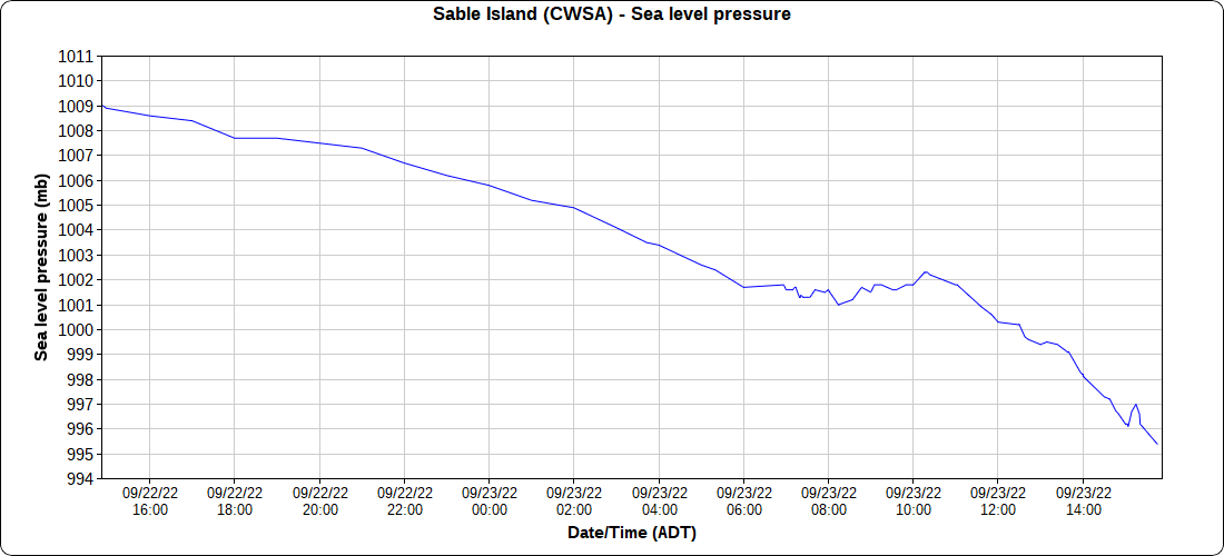
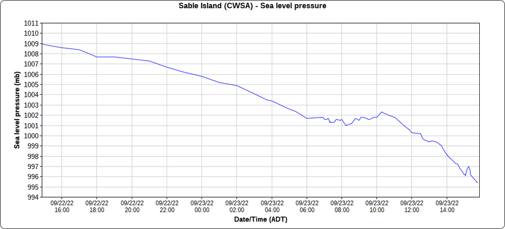
Pressure now down to 995mb on Sable Island. Winds are still fairly calm.
-
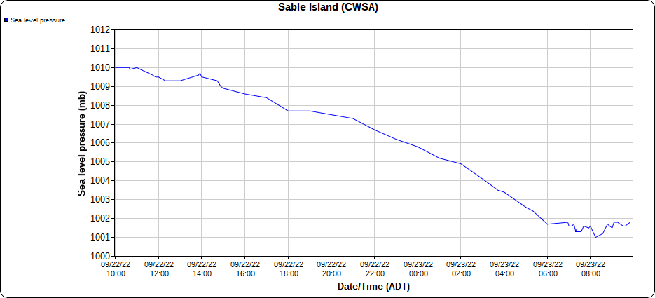
Sea Level Pressure plot from Sable Island from the past 24 hours, you can find these graphs on the MesoWest website: https://mesowest.utah.edu/cgi-bin/droman/meso_base_dyn.cgi?stn=CWSA&unit=1&time=LOCAL&product=&year1=&month1=&day1=00&hour1=00&hours=24&graph=1&past=0&order=1 *And to note, on the left hand side of that website, you can change between metric and English units*
-
Sable Island is at the max like 30 feet tall. Cut those 50 foot waves south of the island to like 25 feet and it's still tragic.
-
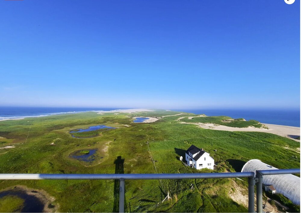
For those that haven't been or seen pictures of Sable Island... This was a picture I took there this summer atop the West Light lighthouse. The island is only 1 mile wide at the largest point, 26 miles long. That white house below is where I stayed for the summer, it was only a 2 minute walk to the north side beach, and maybe a 5 minute walk to the south side beach. I bring this up to mention the true lack of anything there. I can't imagine what surge is going to look like
-
-
I was apart of a research group on Sable Island this summer, so it holds a very special place in my heart. If you don't know where Sable Island is, it's that small crescent Island south of Nova Scotia about 200 miles off the coast. I can't imagine what the scene will be on that island this coming Saturday. They've seen quite their fair share of storms, but this will be truly special. If I had to place a Webcam anywhere, it would be there. The surge could be unheard of. Wind is less of an issue due to minimal infrastructure and blowing of debris. But I am super interested to see how this plays out for Sable and mainland Nova Scotia
-
Here is the current Bermuda radar at 2137 UTC
-
I just got back from backpacking the 28 mile Old Loggers Path this week up north of Williamsport near Canton, PA (Northwest corner of Sullivan County). As I was expecting and prepared for, many many streams were dried up along the trail. Only two reliable streams along the whole loop had any water for drinking. I was on the same trail last summer in July and I made a comparison video of the Pleasant Stream that runs through the trail and must be forded/crossed. I wanted to share with you guys, I thought it was very impressive. It highlights the incredibly dry summer that parts of the Northeast US have seen. And again just for comparisons sake, last summer the "stream" (which flowed more like a raging river) was waist deep when crossed. This summer, it was only a gentle trickle with plenty of rocks to hop on.
-
Tornado warning for Elk County, very solid radar signature with an impressive hook and moving SE
-
Looks more like a potent MCS that could move through according to the NAM
-
Tornado warning just west of Duncannon!
-
SVR Watch coming
-
SVR Watch coming soon