Newman
-
Posts
2,500 -
Joined
-
Last visited
Content Type
Profiles
Blogs
Forums
American Weather
Media Demo
Store
Gallery
Everything posted by Newman
-

E PA/NJ/DE Winter 2022-2023 OBS Thread
Newman replied to Ralph Wiggum's topic in Philadelphia Region
-
E PA/NJ/DE Winter 2022-2023 OBS Thread
Newman replied to Ralph Wiggum's topic in Philadelphia Region
Euro looks just like the GEM at hour 72, nothing like the GFS with it's handling of the PV lobe that acts as our confluence. -
E PA/NJ/DE Winter 2022-2023 OBS Thread
Newman replied to Ralph Wiggum's topic in Philadelphia Region
You are right, I went back and checked the 6z and there were more cutters than anything else. Good news there at least -
E PA/NJ/DE Winter 2022-2023 OBS Thread
Newman replied to Ralph Wiggum's topic in Philadelphia Region
There are a couple individual members that cut it to Buffalo, but the mean and lean is certainly SE and off the coast. There's a couple cutters, bombs, and complete whiffs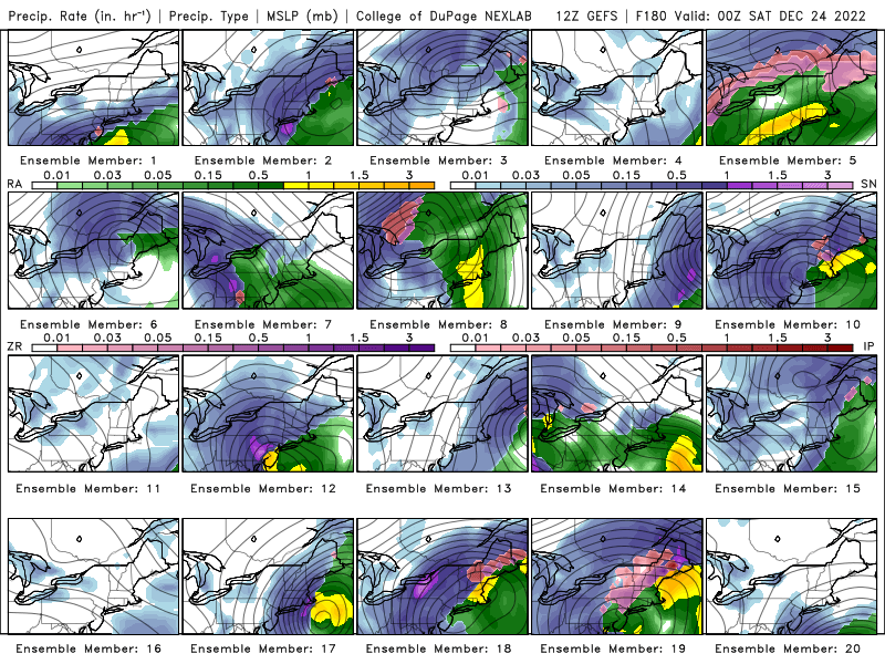
-
E PA/NJ/DE Winter 2022-2023 OBS Thread
Newman replied to Ralph Wiggum's topic in Philadelphia Region
I know we're over a week out still, but I'm gonna need a good Euro run here in an hour to give me a little more hope. The GFS is wonderful, but it's on it's own. I'm really not looking forward to a model war for the next week if that's the case -
E PA/NJ/DE Winter 2022-2023 OBS Thread
Newman replied to Ralph Wiggum's topic in Philadelphia Region
The differences between the CMC and GFS are huge even 5 days out. There is no confluence whatsoever on the CMC -
Central PA Winter 2022/2023
Newman replied to Blizzard of 93's topic in Upstate New York/Pennsylvania
-
E PA/NJ/DE Winter 2022-2023 OBS Thread
Newman replied to Ralph Wiggum's topic in Philadelphia Region
-2 in Altoona and a balmy 58 in Philadelphia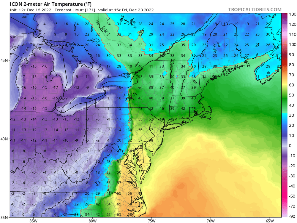
-
E PA/NJ/DE Winter 2022-2023 OBS Thread
Newman replied to Ralph Wiggum's topic in Philadelphia Region
Raleigh NC the place to be on that GFS run, back to back jackpots less than 3 days apart -
Central PA Winter 2022/2023
Newman replied to Blizzard of 93's topic in Upstate New York/Pennsylvania
Is it wave spacing, the fast flow, unlikely "perfect" phase, geographic location, or something else that would make you say the ceiling is a SECS? -
E PA/NJ/DE Winter 2022-2023 OBS Thread
Newman replied to Ralph Wiggum's topic in Philadelphia Region
From Mount Holly This changes as we go to the end of the week. While there are timing and placement differences with the long term guidance, all of the long term models are indicating the potential for a coastal storm to affect the east coast Thursday into Friday. Each have a coastal storm developing to our south, before a disturbance moves in from the west, bringing colder air with it to the area, and strengthening the low as it approaches. This is a week away, so there is plenty of uncertainty, so for now we will stay close to the NBM for the forecast. -
E PA/NJ/DE Winter 2022-2023 OBS Thread
Newman replied to Ralph Wiggum's topic in Philadelphia Region
I've always been a HECS or bust type of person when the ingredients are all on the table. A sneaky 2-4" event two days before? Definitely welcomed. A big dog being progged days to weeks out? Yep, give me the big thing. I will of course take anything for a White Christmas, but I will be chasing this thing for big one potential -
E PA/NJ/DE Winter 2022-2023 OBS Thread
Newman replied to Ralph Wiggum's topic in Philadelphia Region
Agree, the timing was off and we still got widespread 6+". The ceiling is without a doubt 12"+ widespread, but guidance showing warning level snows even with the pieces sloppy is encouraging -
E PA/NJ/DE Winter 2022-2023 OBS Thread
Newman replied to Ralph Wiggum's topic in Philadelphia Region
Happy Hour GFS with a nuke! -
E PA/NJ/DE Winter 2022-2023 OBS Thread
Newman replied to Ralph Wiggum's topic in Philadelphia Region
-
Snowing again, mid-level warm layer is crashing and can see mix line moving back south on correlation coefficient.
-
E PA/NJ/DE Winter 2022-2023 OBS Thread
Newman replied to Ralph Wiggum's topic in Philadelphia Region
-
E PA/NJ/DE Winter 2022-2023 OBS Thread
Newman replied to Ralph Wiggum's topic in Philadelphia Region
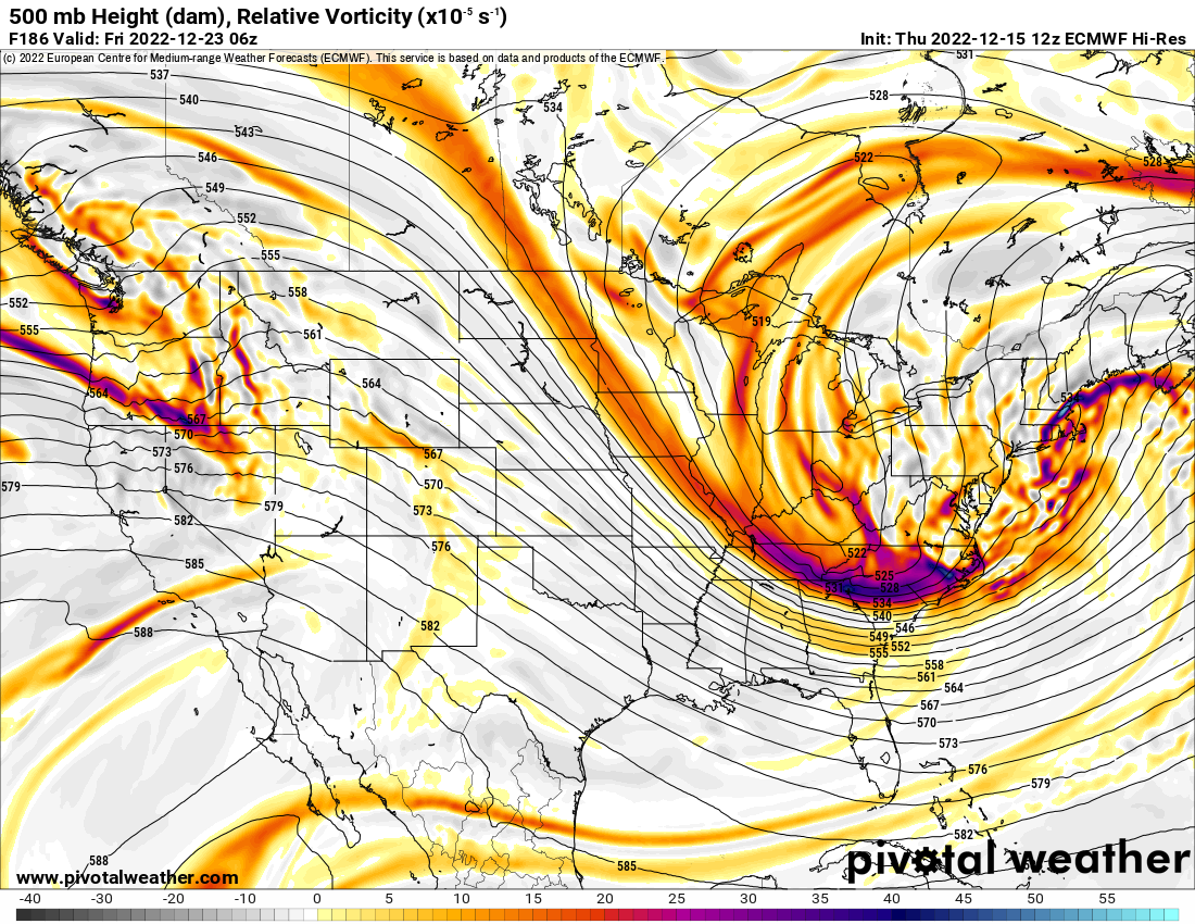
Euro is soooo close. Verbatim still gives the entire area light snows, but we're talking miles and it could've been another bomb. This 500 look is out of the NESIS textbook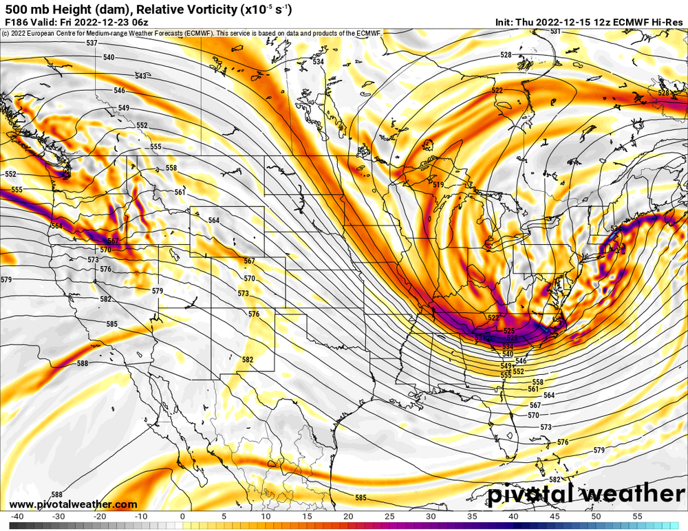
-
Central PA Winter 2022/2023
Newman replied to Blizzard of 93's topic in Upstate New York/Pennsylvania
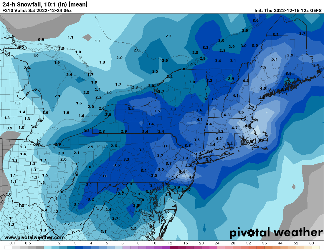
Current mean on the GEFS for the 23rd system is very impressive being 8 days out. Some huge hits, and the miss right now would be a SE scraper, not NW and a cutter.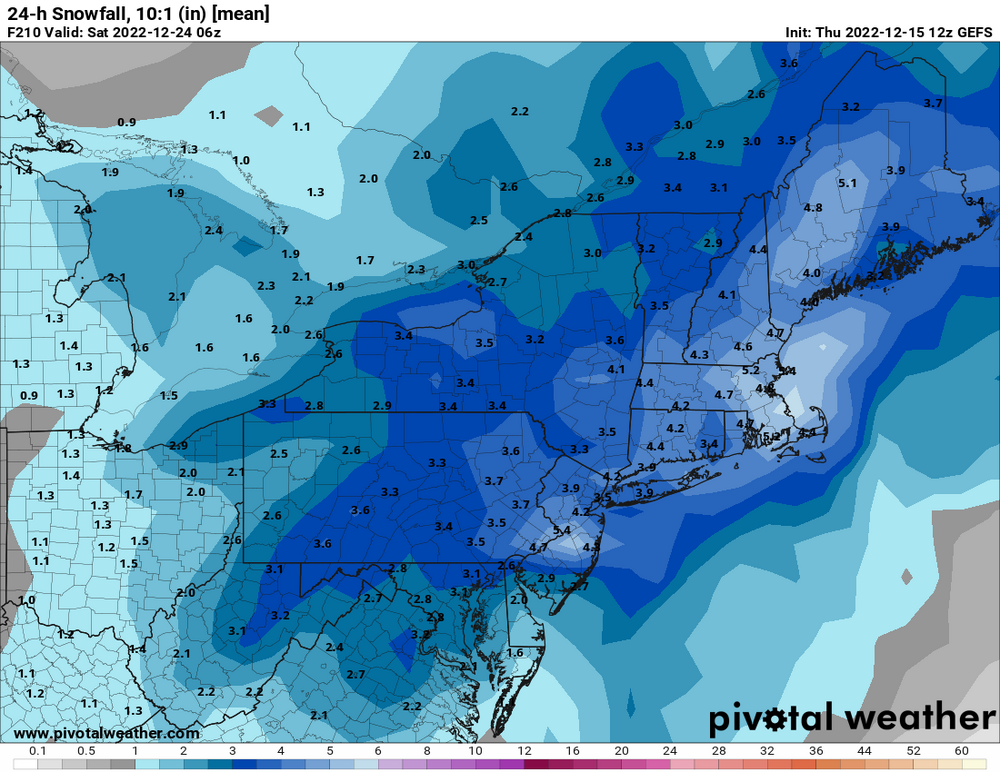
-
E PA/NJ/DE Winter 2022-2023 OBS Thread
Newman replied to Ralph Wiggum's topic in Philadelphia Region
There are some huge indi GEFS members this run. Some faster on the 23rd, some slower on the 24th. Multiple hits, and the lean right now would be a SE scraper, not NW and a cutter. The mean 8 days out is an advisory, borderline warning level, snowstorm
-
E PA/NJ/DE Winter 2022-2023 OBS Thread
Newman replied to Ralph Wiggum's topic in Philadelphia Region
Christmas Day wind chills -
E PA/NJ/DE Winter 2022-2023 OBS Thread
Newman replied to Ralph Wiggum's topic in Philadelphia Region
Closed low opens up and just squeaks by to our SE that it's mainly a coastal bomb. It was so close to being a widespread MECS -
E PA/NJ/DE Winter 2022-2023 OBS Thread
Newman replied to Ralph Wiggum's topic in Philadelphia Region
GFS with a bomb incoming -
Sleet mixing back in, temp has dropped to 30 with the onset of precip. Can see mix line on correlation coefficient radar very well
-
HUGE snowflakes coming down now, mostly snow. Some flakes the size of my palm, no joke. Like almost 2" in diameter