eduggs
-
Posts
5,951 -
Joined
-
Last visited
Content Type
Profiles
Blogs
Forums
American Weather
Media Demo
Store
Gallery
Everything posted by eduggs
-
Back to back daytime 1-2" events with lollis to 3" on a weekend. That would be enjoyable if it happened. A little less for eastern/coastal areas with the first and more with the second.
-
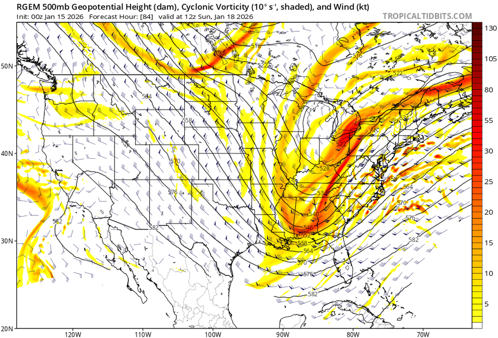
Ideally you don't want multiple shortwaves stacked such that the northerly ones are displaced right of the trof axis like the entire thing is toppling over. That inhibits neutral/negative tilting of the trof. Or more precisely it indicates that the overall flow isn't conducive to negative tilting. The RGEM isn't a bad run - we're still in the game - but it has clear flaws.
-
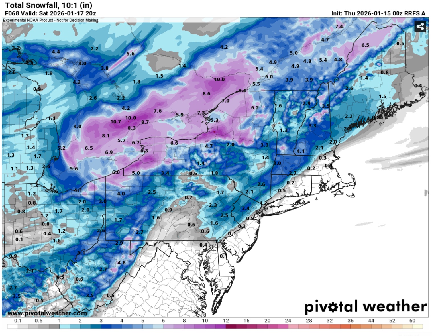
RGEM pretty snowy Sat.
-
Yeah both GFS-AI and ECM-AI ticked better.
-
-
Yup! The GEFS members are clustered well southwest of both 18z and 12z and precipitation is also much further west. Interestingly the mean trof position isn't improved.
-
Yes. And at 84 there is no snow yet from the developing coastal but it looks like it would be at least a minor event along the coast.
-
The GEFS are much wetter along the Gulf in MS, AL, and GA compared to previous runs. This makes sense with the base of the trof further west and approaching the Gulf. Not sure yet if the moisture will translate northward along the coast or shift mostly offshore. Looks like a close call.
-
The RRFS has a couple inches on Sat. N&W
-
Borderline warning snows on the GDPS for NYC
-
Yeah plenty of time to shift either way. I'd like to see the trof a little sharper so the SLP tracks with more of a north component than east. That would also strengthen the SLP and mid-level lows to wrap more moisture west.
-
More for LI. And could be solid ratios too.
-
Starts west but dampens at h5 and slides east. A nice run but not 12z.
-
Going to be more Gulf inflow on the GFS.
-
Yeah, it looks really good. An improvement over the 12z GDPS. It's a little faster than the 18z GFS, but actually a little west of it at the surface. That's a plowable snowfall incoming on the model.
-
So far everything ticked a little better at 0z. That's better than the opposite. Looks like a burst of snow or rain on Sat. and a close call for something Sunday. Still a little time to trend better.
-
Seems like not much changed overall. The GFS is the strongest western outlier and a model blend would bring a near miss or scraper. Multiple micro-lows and vorticity near the Lakes works against us. The optimal solution involves a vormax near the base of the trof to sharpen it up and involve Gulf moisture. With some ridging out ahead of the trof, that would bring precipitation up the coast and keep a SLP more closely tucked. Otherwise this ends up more offshore.
-
Anything beyond 5 days was long range 15 years ago. There were fewer publicly available models, some of which ran only once or twice a day. Most people viewed models on the NCEP site instead of 3rd party vendors where you can quickly toggle between models & runs. Social media was also in its infancy.
-
It kind of looks like the better snow threat (at least away from the immediate cost) is Sat the 17.
-
ICON and RDPS are 1-4" for Saturday. We take.
-
I think the snow talk is referring to Saturday. Yes that's the best snow threat at this juncture. So far 18z is worse for the Sun/Mon coastal threat. You don't want shortwave troffing (concave up) northeast of the vortmax at the base of the trof. That's a recipe for a late trof evolution and OTS solution. The 12z ECMWF moved a vorticity-laden shortwave through OH and NY early Sunday, which ruined the coastal threat. The 18z NAM/ICON increased troffing (concave up) in this area. By comparison, the 12z GFS had subtle shortwave ridging (concave down) over NYS.
-
You don't want shortwave troffing (concave up) northeast of the vortmax at the base of the trof. That's what sabotages the coastal threat on the 12z ECMWF and that's that the 18z NAM/ICON shifted more towards. By comparison, the 12z GFS had subtle shortwave ridging (concave down) over NYS.
-
There aren't any GEPS or GEFS members either.
-
Yes snow on Saturday is more likely at this point than Sunday or Monday.
-
You are wishcasting. The 18z is unmistakably a shift towards the ECMWF. But the differences are relatively minor and there's still time to improve this.