eduggs
-
Posts
5,951 -
Joined
-
Last visited
Content Type
Profiles
Blogs
Forums
American Weather
Media Demo
Store
Gallery
Everything posted by eduggs
-
Extreme Cold, Snow & Sleet: SECS 1/24 - 1/26
eduggs replied to TriPol's topic in New York City Metro
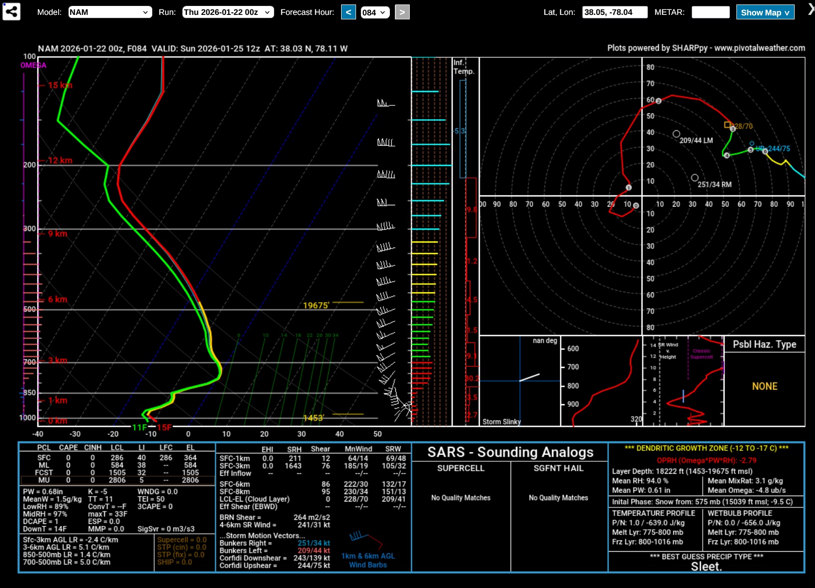
This is the kind of NAM sounding that makes me nervous about sleet on Sunday. It's valid at 12z Sunday morning about 50 miles NW of Richmond, VA. Super cold surface & 850mb temps with 700mb temps -2C or -3C and the ptype is SLEET because of a pronounced warm layer near 750mb. The surface high can't save us from that. If the upper levels are amped and the mid-level lows which will track to our west are slow to weaken, our sounding could end up looking like that on Sunday afternoon/evening. That would be a bummer considering the depth of saturation through that column... would be a lot of QPF wasted as sleet.
-
Extreme Cold, Snow & Sleet: SECS 1/24 - 1/26
eduggs replied to TriPol's topic in New York City Metro
3 out of 30 GEFS members develop a significant and deepening coastal SLP on Monday between NJ and LI (like the 0z ICON) and extend precipitation into early Tue. -
Extreme Cold, Snow & Sleet: SECS 1/24 - 1/26
eduggs replied to TriPol's topic in New York City Metro
Love the mounting evidence for a 1"+ liquid event. That's big dog stuff. -
Extreme Cold, Snow & Sleet: SECS 1/24 - 1/26
eduggs replied to TriPol's topic in New York City Metro
FWIW, I'm seeing about 1.3" for the UK and 1.1" for the GFS on Pivotal -
Extreme Cold, Snow & Sleet: SECS 1/24 - 1/26
eduggs replied to TriPol's topic in New York City Metro
With that prolonged easterly fetch some of the spots in SENJ and EMA that are favored for ocean enhancement could approach 2" liquid - a lot of which could be frozen. Great to see both the ICON and UK well over 1" liquid across most of our area. -
Extreme Cold, Snow & Sleet: SECS 1/24 - 1/26
eduggs replied to TriPol's topic in New York City Metro
The UKIE is ICON-esque! Maybe a tick warmer than the ICON but better than 12z IMO. Threatens a mix/dryslot or at least lull, but redevelops on Monday! Sweet run! -
Extreme Cold, Snow & Sleet: SECS 1/24 - 1/26
eduggs replied to TriPol's topic in New York City Metro
Through 18z Sat the UK is a little flatter than 12z. Still amped but a tick less. I'd prefer small run-to-run changes anyway, especially if they are in the right direction. -
Extreme Cold, Snow & Sleet: SECS 1/24 - 1/26
eduggs replied to TriPol's topic in New York City Metro
It's actually one of the best global models in the world. The only clearly superior model in terms of verification is the ECMWF. -
Extreme Cold, Snow & Sleet: SECS 1/24 - 1/26
eduggs replied to TriPol's topic in New York City Metro
I feel like the CMC has been doing better than the GFS this year. It's purely anecdotal but I don't trust the GFS at all. -
In Europe, the ICON is considered a superior model to the GFS particularly out to 72 hours and across mid-latitudes. The GFS does not have the dominant perch amongst global models that it used to have.
-
Extreme Cold, Snow & Sleet: SECS 1/24 - 1/26
eduggs replied to TriPol's topic in New York City Metro
The 0z RGEM is also a tick less amped than 18z but still pretty amped. -
Extreme Cold, Snow & Sleet: SECS 1/24 - 1/26
eduggs replied to TriPol's topic in New York City Metro
FWIW, the 0z NAM matches up pretty well with the 12z CMC at 500mb. But it also ticked a little less amped the past 2 runs. -
Extreme Cold, Snow & Sleet: SECS 1/24 - 1/26
eduggs replied to TriPol's topic in New York City Metro
The 0z ICON is a dream run for pretty much our entire forum - CNJ north. There is a precip. lull Sunday night but it redevelops on Monday and stays mostly snow. I said after 18z that a slight shift south would produce an excellent long duration event and that's exactly what the model shows. Very widespread heavy snow event for most of the northeast, which is uncommon! -
Extreme Cold, Snow & Sleet: SECS 1/24 - 1/26
eduggs replied to TriPol's topic in New York City Metro
The 18z ICON is relatively warm and amped, but it also shows a pathway to really big totals and a longer duration event. With a full phase there is a sharp trof back to the west Sunday night. This partly captures the surface low over the Atlantic and induces another round of precipitation in EPA, NJ, SENY, and SNE on Monday after nearly dryslotting late Sunday. Notice the 18z ICON isn't done snowing at 120hrs. It shows a nearly stalled and intensifying 995mb low just off NY Harbor with light to moderate snow throughout the area. A few model runs (and several individual ensemble members) have blown up this coastal low adding several tenths of QPF on Monday. Shift the ICON slightly south with the overrunning and you have a very significant and long duration event.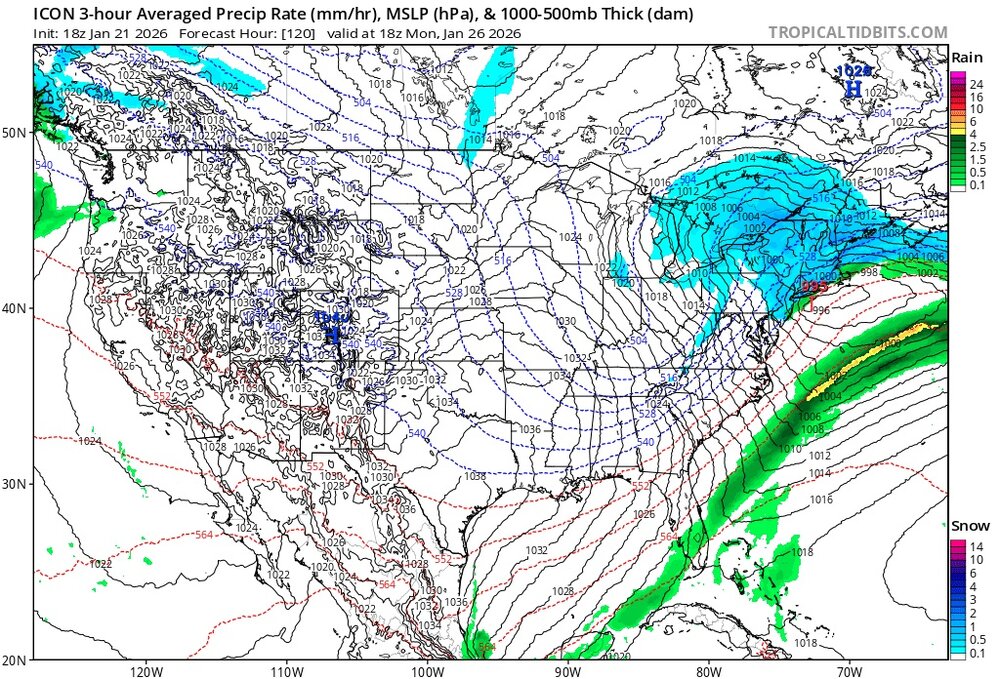
-
Extreme Cold, Snow & Sleet: SECS 1/24 - 1/26
eduggs replied to TriPol's topic in New York City Metro
Check 500mb. This is very helpful for visualizing the movement of storms. Surface features like surface highs and lows affect surface parameters like wind and surface temperature. But they don't affect shit aloft. They RESULT FROM upper level features. They get steered by the upper levels, not the other way around. -
Extreme Cold, Snow & Sleet: SECS 1/24 - 1/26
eduggs replied to TriPol's topic in New York City Metro
The warmest layer might not be 850mb. It could be higher up. -
Extreme Cold, Snow & Sleet: SECS 1/24 - 1/26
eduggs replied to TriPol's topic in New York City Metro
Don't assume it can't trend even worse. -
Extreme Cold, Snow & Sleet: SECS 1/24 - 1/26
eduggs replied to TriPol's topic in New York City Metro
The GFS has not been good lately relative to the Euro, CMC, and UKMET. I don't trust it at all, especially when it's an outlier. I like the ECM-AI as a model - it's a little less amped than the other 3 so it gives me some encouragement. -
Radar shows an impressive line of reflectivity associated with a warm front from KY to SPA pointed straight at us. HRRR says it all dries up before reaching the ground, but I'm still hoping to sneak a few flurries or maybe even a dusting out of it.
-
Extreme Cold, Snow & Sleet: SECS 1/24 - 1/26
eduggs replied to TriPol's topic in New York City Metro
Careful locking in a foot Imagine how you would feel looking out the window at a dryslot and 5" of snow as BGM and ALB sail past 18" on their way to 24". Think you would feel good about your major snowstorm? -
Extreme Cold, Snow & Sleet: SECS 1/24 - 1/26
eduggs replied to TriPol's topic in New York City Metro
I feel like I'm one of the few being even keeled. I'm describing the situation as it is - not how I wish it were. It's a legit big snowstorm threat. But there are concerns, particularly with recent trends. It's weather forecast discussion... not a pants tent meme party. -
Extreme Cold, Snow & Sleet: SECS 1/24 - 1/26
eduggs replied to TriPol's topic in New York City Metro
There are several individual ensembles that show less than 6" including some that show a complete miss. There is also still time for modeling to shift much further north or south. We can all see what model consensus is right now. But that doesn't mean we can guarantee a future outcome. -
Extreme Cold, Snow & Sleet: SECS 1/24 - 1/26
eduggs replied to TriPol's topic in New York City Metro
True worst case from 4 days out is almost always 0. A reasonably plausible low low end is probably in the range of 2-4". A baseline target would be 6". -
Extreme Cold, Snow & Sleet: SECS 1/24 - 1/26
eduggs replied to TriPol's topic in New York City Metro
Mixing signals the end of the main show, because once 700mb - 850mb rises above freezing, the WAA is over... lift has moved to our north. The duration before the main show ends has decreased over the past day or two. Mixing is associated with dryslot and a shorter duration of snow, which is why I'm concerned about it. -
Extreme Cold, Snow & Sleet: SECS 1/24 - 1/26
eduggs replied to TriPol's topic in New York City Metro
Yes mixing is clearly a concern now with the upper level support well to our northwest on Sunday. Heights and thickness values are surging during the day on Sunday. The CMC shoots the initial shortwave south of Chicago to near Detroit and Buffalo. Then on Monday the ULL is near Sault Ste. Marie... super amped! The Euro isn't too far off. If that's correct, we'll probably have more mixing issues faster than modeled on Sunday. We may not see it until Fri when the NAM is fully in range. The ski areas of the North Country are starting to look great for a long-duration snow event. That's usually a bad sign. The 500mb chart at 0z Monday would look like a rainstorm if you didn't see the preceding panels. I think we should pump the breaks on the Kuchera and NBM snowfall maps and hope for a flatter trof evolution in subsequent model runs.