eduggs
-
Posts
5,951 -
Joined
-
Last visited
Content Type
Profiles
Blogs
Forums
American Weather
Media Demo
Store
Gallery
Everything posted by eduggs
-
Extreme Cold, Snow & Sleet: SECS 1/24 - 1/26
eduggs replied to TriPol's topic in New York City Metro
I don't mind a little sleet. But with the way the UK, ECM, and CMC are evolving, the duration of overrunning is shortening. The ptype mix is indicating that the best dynamics have shifted north and we get dryslotted. If precip. blossoms thereafter as the hang-back trof approaches and a new surface reflection forms south of LI, then that would change the tenor and mitigate any lull. It could be the difference between a relatively quick hitting 6-10" and a long duration 10-18". -
Extreme Cold, Snow & Sleet: SECS 1/24 - 1/26
eduggs replied to TriPol's topic in New York City Metro
The ECM and CMC show upper 20s at NYC late Sunday night. With flatter solutions a day ago, this was low 20s. -
Extreme Cold, Snow & Sleet: SECS 1/24 - 1/26
eduggs replied to TriPol's topic in New York City Metro
Only if the upper levels as depicted are too amped. If future runs are a little "flatter," the primary will weaken sooner. -
Extreme Cold, Snow & Sleet: SECS 1/24 - 1/26
eduggs replied to TriPol's topic in New York City Metro
The ECMWF is 12-18 hours of snow then light mix/dryslot with possibly some steadier mix or snow at the tail end. That would include a very solid "thump." -
Extreme Cold, Snow & Sleet: SECS 1/24 - 1/26
eduggs replied to TriPol's topic in New York City Metro
Surface features aren't in control. A surface high can't block anything. Surface features, including highs and lows, are the result of the upper levels. Look at this 500mb chart. We're pushing 560dm with a vorticity packet and shortwave headed for the Lakes. That absolutely can send a strong primary to southern Ontario. We're lucky we have a good cold airmass in place, otherwise this would be ice to rain. -
Extreme Cold, Snow & Sleet: SECS 1/24 - 1/26
eduggs replied to TriPol's topic in New York City Metro
With a full phase there's nothing to stop a primary surface low from tracking to southern Ontario. The mid-level lows are well west of us. Several EPS members were even more amped than the 0z ECM OP. On tonight's runs this is starting to look like a supercharged SWFE. I'm really curious if this keeps trending in the same direction or adjusts back in the opposite direction with a less-clean phase. I prefer the longer-duration event where we stay on the cold side even if it means less QPF. -
Extreme Cold, Snow & Sleet: SECS 1/24 - 1/26
eduggs replied to TriPol's topic in New York City Metro
The 0z Euro looks a lot like the UKMET. -
Extreme Cold, Snow & Sleet: SECS 1/24 - 1/26
eduggs replied to TriPol's topic in New York City Metro
The GEFS has a single member that takes a UKMET-like track through NYS. The 12 GEPS has 2. And the 18z EPS has 4 or 5 including a few that are more amped than the UKMET. -
Extreme Cold, Snow & Sleet: SECS 1/24 - 1/26
eduggs replied to TriPol's topic in New York City Metro
30+ hours of wintry precip would be fun. Would be a high impact event. Even better if this turns out to be a little less amped than the 0z UK and we can stay all snow. -
Extreme Cold, Snow & Sleet: SECS 1/24 - 1/26
eduggs replied to TriPol's topic in New York City Metro
Flips back to snow on the UK. Wild solution. Can't completely discard it though. Shift that a little less amped and you have a great long-duration event. -
Extreme Cold, Snow & Sleet: SECS 1/24 - 1/26
eduggs replied to TriPol's topic in New York City Metro
Spectacular moisture feed from the Pacific through the Yucatan and then into the Gulf States. A mini-atmospheric river. That's exactly what we want to see pointing at the cold dome in the northeast! -
Extreme Cold, Snow & Sleet: SECS 1/24 - 1/26
eduggs replied to TriPol's topic in New York City Metro
Love the major snowstorm on the CMC for next Thurs. the 29th - lol! -
The RGEM is showing a little snow north of NYC on Wed. night. There is virtually no support... maybe a dusting shown on the NAM3km or a few other mesos... so it's probably not real. But sometimes with cold air in place a surprise minor impulse can produce a quick inch here or there.
-
Extreme Cold, Snow & Sleet: SECS 1/24 - 1/26
eduggs replied to TriPol's topic in New York City Metro
On the EPS individuals I count 13 misses and 11 big hits out of 50. The rest are light to significant hits. ~25% miss rate is still pretty high. Still plenty of variability. -
Extreme Cold, Snow & Sleet: SECS 1/24 - 1/26
eduggs replied to TriPol's topic in New York City Metro
12:1 is a good first guess for ratios IMO. Interior, mountainous regions get great ratios because they get great lift combined with cold. High ratio snow along the coastal plain is usually confined to snow squalls and heavy banding. Long-duration light-moderate snow might not coincide with enough lift in the snowgrowth zone to get higher ratios. Locking in 15:1 could lead to disappointment. -
This looks like a good candidate for ocean enhancement in the favored spots of EMA and SE NJ. Pretty high potential locally if we can avoid the GFS-type solution.
-
Extreme Cold, Snow & Sleet: SECS 1/24 - 1/26
eduggs replied to TriPol's topic in New York City Metro
The positive spin is the ECM and ECM-AI are clearly worse aloft at 12z than the previous 2 runs. The phase is "less clean"... and yet they both still produce a major snowstorm. That's encouraging. It suggests outcome resiliency and a buffer against negative trends. The negative spin is that the ECM and ECM-AI were clearly worse aloft at 12z in a direction that, if it continued to trend, would lead to a GFS-like solution. -
Extreme Cold, Snow & Sleet: SECS 1/24 - 1/26
eduggs replied to TriPol's topic in New York City Metro
That would be great if this were a 36 hour forecast. I'm just sensitive to any negative trends because this could disappear quickly if any piece doesn't align. The AIs and ensembles still aren't fully on board. -
Extreme Cold, Snow & Sleet: SECS 1/24 - 1/26
eduggs replied to TriPol's topic in New York City Metro
The 12z ECMWF is a step back from 6z and 0z. The phase is not as clean. It's still a great storm as depicted, just not as favorable as the past 2 runs. -
Extreme Cold, Snow & Sleet: SECS 1/24 - 1/26
eduggs replied to TriPol's topic in New York City Metro
I'm happy it's the GFS showing the miss and not the CMC, ECMWF, or UK. But big snowstorms are uncommon - everything has to go right and usually doesn't. So it's reasonable to be on guard for what might go wrong. Any signs of trending towards the GFS should be concerning if you want a big snow event. -
Extreme Cold, Snow & Sleet: SECS 1/24 - 1/26
eduggs replied to TriPol's topic in New York City Metro
If we trend towards the GFS-family, this could be a non-event. The 12z ECM-AI was actually a step towards that solution aloft, despite what it printed out in terms of QPF. If we get a 6z ECMWF, 12z UK/ICON/CMC event, then this is definitely a NESIS/KU event with significant snow from Richmond to Boston. I'm far from comfortable characterizing reasonable QPF expectations at this point. First I want to get more confidence that the 12 GFS solution is unlikely. -
Extreme Cold, Snow & Sleet: SECS 1/24 - 1/26
eduggs replied to TriPol's topic in New York City Metro
The models and ensemble members that have a better phase are slower with the overrunning arrival and longer in total duration (CMC, UK, 6z ECM-AI). The worse phasing models (GFS, GFS-AI, 12z ECM-AI) are faster to arrive and shorter duration. -
Extreme Cold, Snow & Sleet: SECS 1/24 - 1/26
eduggs replied to TriPol's topic in New York City Metro
The 12z ECM-AI clearly has more wave interference than 6z. Slower ULL ejection and worse phasing. It's not as favorable a solution as last run, which was very good. -
Extreme Cold, Snow & Sleet: SECS 1/24 - 1/26
eduggs replied to TriPol's topic in New York City Metro
Everything is dependent on the height field orientation and evolution. The cold air is in place to the north. There is ample moisture to the south. If the isoheight lines are oriented mostly west to east (zonal) on Sat & Sun from North Texas to North Carolina (e.g., GFS), then this is likely a southeast and mid-Atl snowstorm. If the isoheight lines evolve with more of a north-facing component (meridional), the moisture will track further north. The more meridional the height field, the more QPF we will likely get up in our region. The placement of surface features (highs, lows, precip. field) are a reflection of the mid-and upper-level height field. To get a favorable height field we need the ULL to eject east and a favorably timed northern stream shortwave to partially or fully phase. -
Extreme Cold, Snow & Sleet: SECS 1/24 - 1/26
eduggs replied to TriPol's topic in New York City Metro
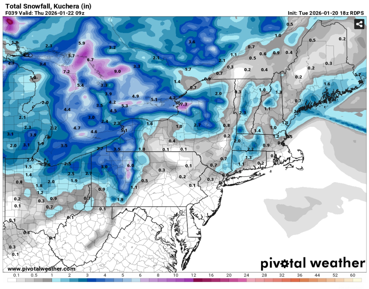
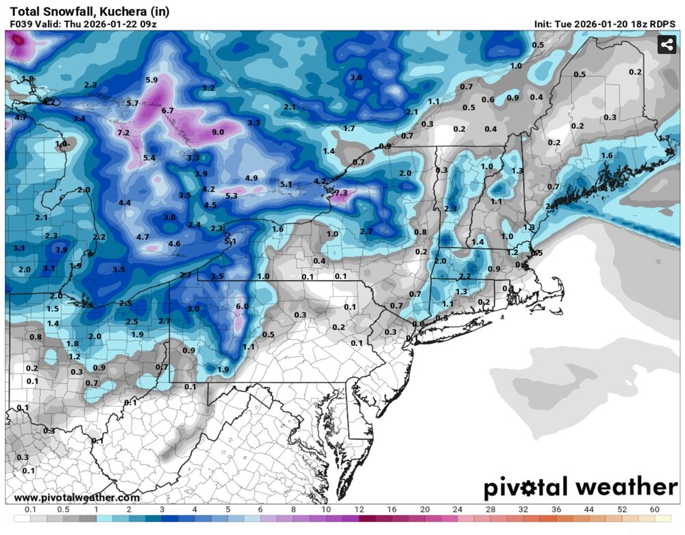
Most of the area is over 0.75" liquid on the CMC. ELI and parts of SWCT are over 1". It's much "wetter" than the GEFS mean.