eduggs
-
Posts
5,951 -
Joined
-
Last visited
Content Type
Profiles
Blogs
Forums
American Weather
Media Demo
Store
Gallery
Everything posted by eduggs
-
I've followed him for multiple years and he has a poor track record with medium and long range forecasting. I respect his enthusiasm a lot, but he is not yet a good forecaster. Brooklyn does not know what he does not know. He is young and inexperienced and has an unrelenting positive bias. It's relatively straight-forward to describe long-range ensemble anomaly charts in numerical terms and translate that to known pattern configurations. But that doesn't make you a good forecaster at all. Of the hundreds of times he has created an animation to illustrate a positive trend, exceedingly few have preceded a snowy outcome. If you knew me personally or bothered to read my posts, you would know that I am not a troll. I believe in facts and science, not BS and voodoo.
-
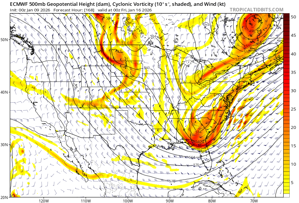
The ECM-AI is another model that looks worse than 6z. Even as early as 5 days out, it's clear aloft that Thurs. will be a miss. There is still time, but synoptic details and trends do matter at this time range.
-
The point remains. The closer a threat, the clearer we can see its flaws. E.g, ensemble means blend and hide shortwave details that appear in closer ranges. Choosing the 2nd showcase because we don't like the look of the 1st isn't always correct. Jan 15 at one time had a very favorable "look" too.
-
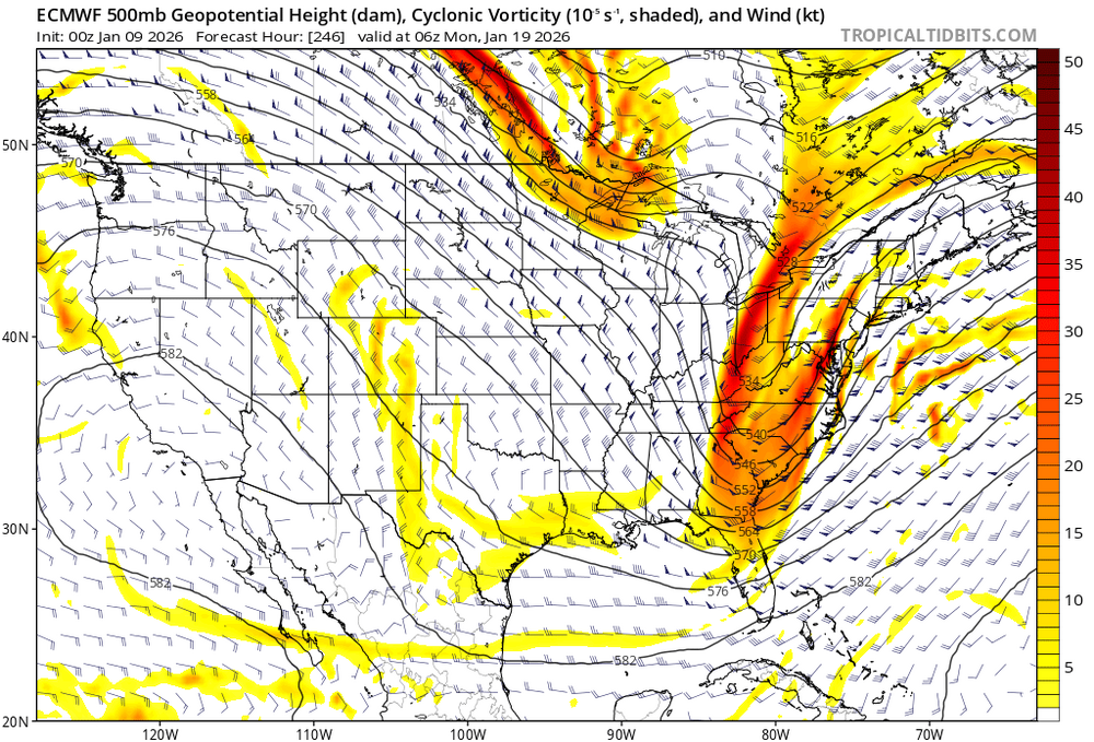
The 0z ECM at 168hr looks remarkable similar to 246hr. It easy to say now that we prefer the later threat, but when that threat gets nearer it might not look any better.

-
12z GFS is closest to an east coast snowstorm. It has a thin, high amplitude trof that rapidly takes on a negative tilt. This is at the extreme end of its multi-day ensemble spread. And it still misses well east. Then look at the CMC, ICON, and UK. All not close. GFS-AI and ECM are less dreadful but not great. Any reasonable look at this would have to conclude that an east coast snowstorm next week is a longshot at this juncture. I really really hope it changes for the better. But if we want to be rational, we should acknowledge the situation for what it is.
-
It wasn't a good 12z cycle because the modeled trof structure got more hostile for a big east coast event on every single model. And this is occurring during a time period where the run-to-run variability begins to significantly decrease. This is a difficult setup to get high QPF along the coast. There's a reason why so few individual ensemble members on the EPS, GEFS, or GEPS over the past few days have shown big hits. It could definitely happen next week - and I'm rooting as hard as anyone. But right now, statistically, we are more likely to be skunked than to get a major snowstorm.
-
Good luck with that.
-
We need a surface reflection in the southeast for the Thurs. event. Otherwise it's likely light rain/warm or an offshore low. Shortwave energy and low surface pressure in the Lakes region torches our lower levels. It's a symptom of a positively tilted trof collapsing on itself. We need more PVA in the south, not the Lakes. But we are moving away from that idea.
-
Disappointing 12z runs. Guidance starting to converge on a miss next week just as we approach a more reliable model time frame. Ensembles have consistently shown very little snow through the end of next week. Next weekend's potential event is still in fantasy land so hard to get excited about anything that far away.
-
ECM-AI a noticable improvement over previous runs for next week. Still a miss/fringe event but close enough to take seriously. The day 9 event is a hit though largely disregarded due to being in fantasy land.
-
Shame there's no surface reflection to key on in the Gulf and even a partial phase w/southern stream to initiate the trof maturing processes sooner. So we're left hoping for a helacious trof tilt and retrograding SLP.
-
It's a bummer we can't buy a Gulf Coast low. It will take tremendous vorticity advection and a negatively tilted trof to spawn a surface reflection close to the coast in this setup. We are likely stuck with the primary over the lakes and a weak secondary reflection well offshore until the wave gets past New England latitudes. Even a little bit of southern stream interaction with the ULL could generate the surface low we need to initiate the self amplifying processes of surface deepening and trof sharpening. Without that to key on, this looks like a long shot.
-
CMC not looking great either through 120hrs. Similar to GFS.
-
CMC a bit GFS-like so far through 120hr. Probably not going to look great either through 7 days.
-
The GFS is not good for next week. But the AI-GFS looks somewhat promising. And it continues a multi-run improving trend.
-
I'm not sure it means anything, but the 0z GFS-AI looks much better for next week than the GFS. It's also an improvement over 18z. The only time this year that the GFS consistently gave our area snowy runs was Dec 26. And it was wrong. Pretty much any other time it has differed from other guidance and didn't show a wintry outcome, it was right.
-
GFS doesn't look great through 120hr. The developing trof axis is very far east and the ULL is completely shut out. It's looking like we'll still be 8+ days out from anything promising on the GFS.
-
It's never a lock. Just a constant long-range tease. The trick is to get a solid threat inside 7 days on multiple models for consecutive runs. That has been extremely elusive in recent years. Long range average ensemble anomaly charts don't accurately predict storm threats. That's because the favorable "patterns" and "looks" usually don't look so favorable when they shift from blended long range averages to the intricacies and complex interactions of actual 500mb height fields.
-
12z ICON tracked the northern stream shortwave through Wyoming and phased in the ULL early. The 0z is much further east and misses the phase with the ULL. No Gulf low as a result. Also a more positively tilted trof and an Atlantic SLP along the offshore baroclinicity like other guidance. The 12z seemed unlikely since it had no support. But it showed the type of evolution that gives us our best shot at getting a significant coastal snowstorm.
-
On the 0z ICON, the northern stream shortwave tracks further east (Dakotas vs. WY/MT) as it dives southeastward to carve out the longwave trof. The ULL in the southeast is left behind and doesn't phase. No Gulf low and a positively tilted trof structure as a result.
-
The 0z ICON looks nothing like the 12z. It shifted away from a "miller A" type evolution towards model consensus of a positively tilted trof and a weak offshore SLP.
-
The 18z ICON at 120hr isn't going to phase as much of the southern stream into the longwave trof as 12z. Kind of a bummer, but not surprising since it has so little support. It still looks better than the GFS, for example, but it's a little more evidence that the best model outcome is probably wrong.
-
Except for UK, GFS, GFS-AI, ECM-AI, and GEFS.
-
EPS are better than 0z - you could even say much better. The mean shows light precipitation in the Thurs-Fri timeframe whereas 0z was mostly offshore. Several individual members are moderate hits but the majority are still light or misses.
-
It does. The trof structure and evolution is very clear at 12z Thurs. That's a squashed, progressively tilted trof. What happens for the next wave for the weekend and beyond is unknown.