

eduggs
-
Posts
5,951 -
Joined
-
Last visited
Content Type
Profiles
Blogs
Forums
American Weather
Media Demo
Store
Gallery
Everything posted by eduggs
-
It's not great to have the key shortwave missing or in an unfavorable location on the ICON and GDPS... and also the short range NAM and RDPS. Even by 72 hours it's clearly missing... that's approaching short term modeling range.
-
GEFS finally support the op and the UK is hugely improved. Yes precipitation is lacking across all guidance relative to the mid-levels. Is that a function of meager lift and lack of overrunning or will it beef up as we get closer?... If I had to guess right now based on the GFS/ICON/UK general evolution, I would expect locally heavier QPF but a lack of a widespread precipitation shield. In other words, I think the lack of classic overrunning out ahead of a surface low decreases the overall magnitude of QPF that we would normally expect with a strong system... but locally, deformation is probably being undermodeled at this stage by the global models.
-
GFS-AI is a little worse again. It looks like we're still firmly in a wait and see mode. Still really big intermodel and intramodel (ensemble) variability. Huge spread for 4.5 days out. Way too few big QPF solutions for my liking.
-
It's interesting how different the CMC is from the GFS and ICON. The CMC completely lacks the intense follow up shortwave that drops from MN to TN and explosively amplifies the trof. On the Canadian the shortwave and its vorticity is closer to the Lakes and connected to the PV. It this feature on the GFS isn't real, the exotic solutions disappear. Heck even with the GFS evolution we get fringed. I love tracking these types of potential events for the excitement and drama, but they usually don't produce widespread snow.
-
The ICON is still too neutrally tilted. The best PVA is well offshore. We'd want to see vorticity wrapping all the way around the mid-level low towards the coast like the 12z GFS. Otherwise the SLP will track east and away from us.
-
With the possible exception of the GFS (esp 12z), the solutions depicted are primarily deformation precipitation with little or no overrunning frozen precipitation. This makes it more difficult to get a high QPF event. This partly explains the low snow means on the ensembles and AIs. It's only when the solution is extreme (12z GFS) that the big QPF appears.
-
The ULL in interior Quebec is more of an impediment to trof amplification than the shortwave near North Dakota IMO.
-
Looked like a clear improvement to me. Several runs in a row now. But the GFS-AI went the opposite direction. With the ICON also worse, it's kind of a wash. Theoretical high end potential but so many failure modes.
-
I don't think the "kicker" is really negatively interacting much with the lead wave. Typically in fact a lead wave will amplify a trof structure if it's downstream of another wave embedded in the longwave trof. The bigger issue IMO is the ULL in Quebec and its interactions with the developing trof.
-
We talk about a kicker ‘pushing’ a storm, but nothing in the atmosphere is really shoving anything else. The air and pressure features are all just parts of one continuous fluid flow. When a new disturbance approaches, the larger pattern around it changes shape—like ripples on a pond or waves on a rope. The systems all move together because the wind field evolves, not because one feature physically kicks another.
-
Agreed. The UK is pretty damn close to something good. Great 12z so far with GFS, GFS-AI, ICON, and UK upping the ante. Only the Canadian is being stubborn.
-
This shortwave feature may not be well resolved by ensembles. It is what triggers the explosive amplification and the mid-level cutoff on the GFS (and 12z ICON).
-
A caution flag on relying on ensembles for next week. First I should say that I'm a big fan of ensemble modeling. But there is a theory that they do not perform well with explosive and anomalous trof amplification. Seeing the GFS operational at only 5 days out with its superior resolution have virtually no support from its ensembles for more than one run should raise a caution flag. Add to that the GFS-AI and ECM-AI which tend to dampen waves compared to operational models looking more amplified than the CMC, UK, and ECM. It is possible that a relatively fine-scale shortwave with embedded vorticity might contribute to rapid amplification that is not well resolved by ensemble modeling. I would not be so bold as to predict this. But I think it's something to consider.
-
Yeah. Negatively tilted trof with cutoff pretty far south... somewhat like recent GFS runs. I'm less interested in the surface outcome at this point. Gives some support to event potential.
-
The state of the PNA is loosely correlated to local snowfall in our area. That is a shout out to Don S. But there is no predictive, causal link between the two. Now that we are in range of global weather modeling, the state of the PNA has no bearing on the likelihood of seeing snow next week. We can't predict the exact future state of the PNA any better than we can the exact synoptic evolution. As always, it will come down to minor details in the mid- and upper-level height structure and evolution... as yet unresolved.
-
If you look at the ECM, CMC, UK, EPS, GEFS, and GEPS, you think next week has very little chance. We're moving from fantasy land solidly into the mid-range now, and those models don't look very encouraging. But the ECM-AI has improved over the past few runs. And several individual ECM-AI ensembles from 0z also were pretty good hits. That has me at least a little intrigued. Significant snow is still unlikely at this point IMO. Let's start there. But the GFS has shown a negatively tilted trof for multiple runs and we have a second model offering some support. The ECM was also better at 6z than 0z even thought it was not nearly enough. Anomalous trofs are often not well signaled by ensemble modeling.
-
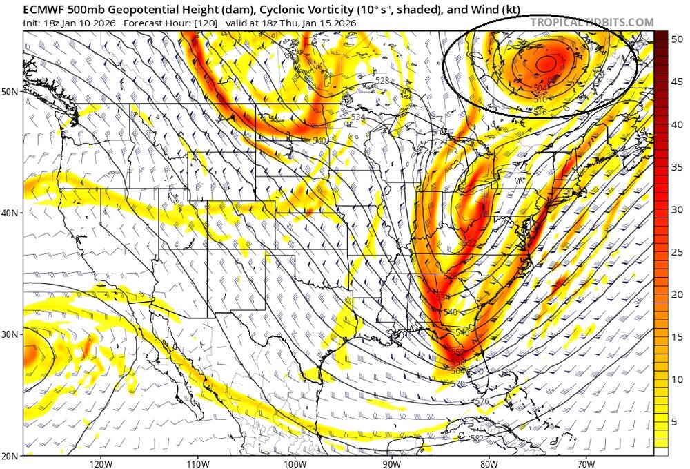
Those maps show two different waves due to timing differences. The first event, roughly slated for Thurs the 15th is already downstream in the Atlantic on the GDPS and the next wave is rolling in. It showed a progressively and positively tilted trof for wave 1. The GFS is wrapped up and cut off southeast of NY harbor so it is much less progressive aloft. Wave 2 is in the northern US and upper MS valley.
-
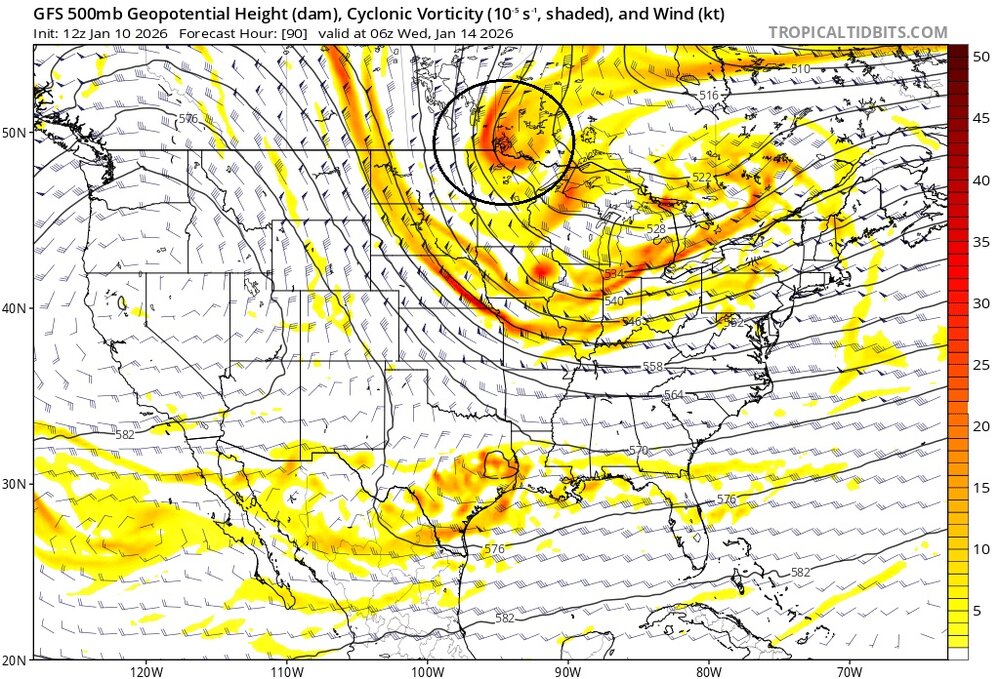
Wow at the 0z GFS aloft. 6z ECM-AI is starting to get a neg tilt look too. It's improved for several runs. But counter to that, the GFS-AI has ticked slightly worse for the same number runs. The GFS in particular shows potential to get a high-end trof alignment even without any southern stream energy rounding the base of the trof... Kind of intriguing. Noteworthy how little support there is for an event near the 15th. 0z GEFS offered a little support, but 6z has withdrew most of it and EPS and GEPS offer almost nothing. The AI models offer more support than the ensembles. This is an interesting test of their relative values. AIs vs ensembles.
-
I said your red tag confers a cloak of expertise that is not deserved. I.E., Bachelor's degree ≠ knowledge & competence. I stand by that. People should be judged based on the quality of their contributions, not a presumption of expertise.
-
I get that for sure. Fully agree. But if you only post positive trends it becomes a boy who cried wolf situation. And your analysis becomes unreliable. That's a meaningful critique.
-
I am responding to your post because I respect you as a poster. I want to limit commentary of a personal nature. I was very clear what I was critiquing with Brooklyn. It only gets murky when multiple people pile on with comments on other comments, and the original context gets lost. Brooklyn made a sarcastic response to someone else's post asking rhetorically if he should "not analyze models." I responded based on his well known propensity to post positive-trend animations that it would be helpful if his "analysis" included both positive and negative trends for a "more balanced" assessment. His response was again sarcastic and insulting. My critique of Brooklyn's style is that his always positive "analysis" regarding long-range charts is not well correlated to sensible weather outcomes. It is not difficult to recognize a favorable "look" on an long-range ensemble chart. ChatGPT does that quite well. There is little value in pointing out these features on 240hr charts. I think he should still be in LEARNING mode more than TEACHING mode. And eventually I think he could offer a lot more than one-sided cheerleading. I am entitled to this opinion, and people can agree or disagree with me if they like. Considering the prolific nature of his posts, Brooklyn should be able to handle legitimate critique. Maybe I'm misjudging him. If he proves me wrong and demonstrates a deeper repertoire, I will happily acknowledge it.
-
I don't want to "attack" anybody. I'm going to stop responding to specific posts that are personal in nature. I've made my point. Wishing deep snow for everybody.
-
I disagree. Prove me wrong. I've been posting on this board for a very long time. I've never read a solid forecast from you. Maybe you only provide them privately. You post the same thing on several sub forums. It's pretty much always the same thing.
-
Legitimate critique. Which you've never offered ever. We can have a competition if you want. Let's compare degrees, or professions, or have a forecasting competition.
-
People like his posts because he is a cheerleader for snow. And that's what people want to hear to make them feel better. But we should be better than that.


