

Daniel Boone
-
Posts
3,544 -
Joined
-
Last visited
Content Type
Profiles
Blogs
Forums
American Weather
Media Demo
Store
Gallery
Everything posted by Daniel Boone
-
Mid to Long Range Discussion ~ 2024
Daniel Boone replied to buckeyefan1's topic in Southeastern States
It's possible. If the EPO is able to extend over the Top and dislodge the Cold and if timed right can drop into the Eastern States. Models are hinting at a -NAO to a degree as well. Odds are low because of the strongly negative PDO and +QBO however ,if you look at it historically. Of course, last Winter went against what would be expected much of the time so, who knows. Sadly, imo, the -PDO is what fouled it up. We need strong cooling of those western PAC SST'S first and foremost and warming in the GOA. In the Atlantic we need cooling of the SST'S off Newfoundland to help support a 50-50 and -NAO. Just this Antique Forecasters Opinion. -
Mid to Long Range Discussion ~ 2024
Daniel Boone replied to buckeyefan1's topic in Southeastern States
The -PDO is the big Dog right now. -
Summer-Fall 2024 Weather Disco Med/Long Range
Daniel Boone replied to John1122's topic in Tennessee Valley
Reached 79.2 here. The longevity and magnitude of the heat is astounding.- 688 replies
-
- 2
-

-
- heat
- thunderstorms
- (and 7 more)
-
Been watching live cams from out there. Nice !
-
Yeah, we've seen that often in recent Winter's.
-
Summer-Fall 2024 Weather Disco Med/Long Range
Daniel Boone replied to John1122's topic in Tennessee Valley
Yeah, my suspicion of a possible warmest Winter on Record is growing, unfortunately.- 688 replies
-
- 1
-
-
- heat
- thunderstorms
- (and 7 more)
-
Good work Chuck. I recently made a possible warmest Winter on Record call on my forum based on how all Drivers are aligned. Now, what you came up with increases my confidence.
-
That may be the case. Winter pf 1971-72 comes to mind
-
Summer-Fall 2024 Weather Disco Med/Long Range
Daniel Boone replied to John1122's topic in Tennessee Valley
Yeah, I am inclined to agree . SST'S look terrible, particularly that never ending Sauna off Japan and south of Aleutians. If that extended into the GOA we'd have better odds at occasional ridging over the top and + PNA. Also a greater likelihood of a+TNH Pattern. NATL. a mess as well. Warm pool off Newfoundland where you want a cold Pool. SST'S look to be set up in a way to create a shot at the warmest on Record. Hopefully not dry as well.- 688 replies
-
- 1
-
-
- heat
- thunderstorms
- (and 7 more)
-
Summer-Fall 2024 Weather Disco Med/Long Range
Daniel Boone replied to John1122's topic in Tennessee Valley
Hopefully not a TC but a strong enough System to move up at the right time and bring us a soaking Rain.- 688 replies
-
- 2
-
-
- heat
- thunderstorms
- (and 7 more)
-
2024-2025 Fall/Winter Mountain Thread
Daniel Boone replied to Buckethead's topic in Southeastern States
Probably just not into it right now with the boring, depressing Pattern we're in and looking at for the foreseeable future. -
Yeah, looks to basically continue the persistent Pattern. When you factor in the strong - PDO, +QBO and Nina along with unfavorable NATL. SST'S that look is what you'd probably expect.
-
Summer-Fall 2024 Weather Disco Med/Long Range
Daniel Boone replied to John1122's topic in Tennessee Valley
With really no to very little help from the STJ, this Winter could be a real barn burner. The MJO at least looks to be able to traverse the colder Phases. Hopefully that continues as should help counter basically everything else unlike the recent round where the intense Convection and LP formation in the Caribbean war'ed against it and helped keep the SER locked in. Hopefully, during favorable MJO Periods we can get a +TNH Pattern. I just don't see much in the way of a - NAO. Strong PV and + QBO. Not good NATL. SST'S. Like you alluded to, things seem a bit off as well. For all we know , everything could go against the Grain. However, We know what the reality is and where it's ultimately going from the greatest book ever written.- 688 replies
-
- 3
-
-
- heat
- thunderstorms
- (and 7 more)
-
Yeah, probably best we can hope for is an occasional +TNH Pattern.
-
Summer-Fall 2024 Weather Disco Med/Long Range
Daniel Boone replied to John1122's topic in Tennessee Valley
Yeah, apparently the strong -PDO , or at least the big warm SST pool out there is what's doing it. Sadly, it's downstream effect has been affecting us as well with the 500 MB Pattern as we know so well from last Winter. I don't really know what it's going to take to finally shift or dissipate that area of warm SST'S. Pacific State is really hurting us.- 688 replies
-
- 2
-
-
- heat
- thunderstorms
- (and 7 more)
-
Summer-Fall 2024 Weather Disco Med/Long Range
Daniel Boone replied to John1122's topic in Tennessee Valley
Same here. From what I gather, some area's to our East are just at Peak now for whatever reason. Peak was about a Week (5-7 days)behind what the average Normal time is here.- 688 replies
-
- 1
-
-
- heat
- thunderstorms
- (and 7 more)
-
Mid to Long Range Discussion ~ 2024
Daniel Boone replied to buckeyefan1's topic in Southeastern States
Probably right. With so many Climate Driver's lined up for warmth in the Eastern US , it has a shot of being one of if not The warmest Winter on Record particularly in the MA and SE.. maybe driest, God forbid -
Mid to Long Range Discussion ~ 2024
Daniel Boone replied to buckeyefan1's topic in Southeastern States
I Remember those late 70's Winter's well. Rivers were frozen and snow covered. Deep Ponds were frozen so thick you could walk across them . For a teenaged snow lover those were like a child living in Toyland. -
Summer-Fall 2024 Weather Disco Med/Long Range
Daniel Boone replied to John1122's topic in Tennessee Valley
Yeah, terrible. -
Summer-Fall 2024 Weather Disco Med/Long Range
Daniel Boone replied to John1122's topic in Tennessee Valley
Not much here but more than what it originally looked like. 0.14"- 688 replies
-
- 1
-
-
- heat
- thunderstorms
- (and 7 more)
-
You mean it needs to warm some
-
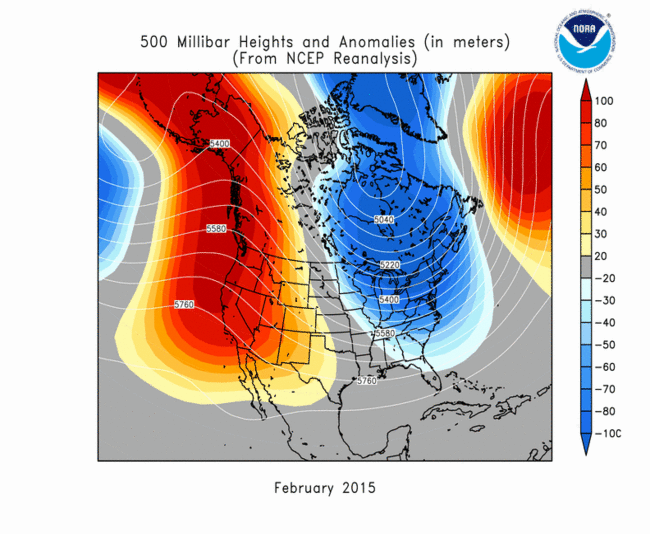
Good points Chuck. If we go back to Feb 2015 we find a +NAO and a Eastern US Trough. +TNH Pattern. If I remember correctly, the QBO was Positive as well. Fly in ointment is definitely the -PDO.
-
Summer-Fall 2024 Weather Disco Med/Long Range
Daniel Boone replied to John1122's topic in Tennessee Valley
If some things connect at the right time, a possibility actually. Timing per usual. -
Summer-Fall 2024 Weather Disco Med/Long Range
Daniel Boone replied to John1122's topic in Tennessee Valley
Noticed Models are hinting at another possible Hurricane hitting Florida somewhere. Some guidance has a similar path as Helene bringing us bountiful Rainfall. Other's going under Ridge and moving East across tip Fla . Apparently contingent on timing and where the HP is. Could have a lot to do with dry or wet next couple weeks. As it stands, westward traversing Convection and developing TC in the Caribbean and along ITCZ in Vicinity seems to be a mechanism helping keep us in locked in HP and Dry. Of course MJO Status is also influencing things.- 688 replies
-
- 1
-
-
- heat
- thunderstorms
- (and 7 more)
-
Summer-Fall 2024 Weather Disco Med/Long Range
Daniel Boone replied to John1122's topic in Tennessee Valley
Yeah it was dry deep then but, the foliage and exposed woodlands are dry enough to support wildfires. The Water levels are not the concern they were then due to what you mentioned.
