gymengineer
-
Posts
3,363 -
Joined
-
Last visited
Content Type
Profiles
Blogs
Forums
American Weather
Media Demo
Store
Gallery
Everything posted by gymengineer
-
This made me laugh out loud. I remember those posts.
-
I've posted about this before- the group of winters when DCA has 2 or more 6" storms is extraordinary in terms of final seasonal totals.
-
Why were you so adamant about the storm being over last night when it was clear on radar it was going to continue? You posted the same thing at 1.5" too. And now, you're reporting around 3" when the lowest report in Montgomery County in the latest PNS is 3.4" and the rest of the reports are 3.6"-6.3". Your neighborhood must just really have a snow-shield microclimate.
-
He had some terrible decisions, like downgrading 2/11/06 to 3-5" just because it was rain/snow mixed in the afternoon. That was the "RAP storm" where Zwyts and company all stayed up late to experience some of the most intense snow bands in the overnight. And he called for 50's and rain multiple times in ice storm/sleet storm situations where CAD was obvious leading into the event. The one major plus side event he nailed was buying the ETA output and declaring the Blizzard of 1996 as a top 5 event for DC on Friday night's 11 pm broadcast, before any other DC TV met did. By the next morning, the events were set in motion for a Saturday pandemonium in preparation for the storm.
-
So, just based on recent reports in this thread, 5" has crossed southern Fairfax County, 4" Falls Church and up to Vienna, the NOVA airports came in at 3" for 7 pm, and Columbia and even BWI were around 2". It looks like the gradient has been more relaxed DC northeastward, and as tight as expected south of DC.
-
This is already the lowest visibility snow since 1/3/22 here in North Bethesda. I wonder if later on, we'll hit 1/2016 type of SN+.
-
I posted this once, and just wanted to reiterate: Dating back to 1957/1958, the minimum seasonal snow total at DCA for any season seeing 2 or more 6” snowstorms is 24”. The sample size is obviously not enormous. But following that pattern, if DCA records 6” on Tuesday, there very well could be 10+” more to come afterwards.
-
Going all the way back to 1957/1958, every single season when DCA has had two or more 6"+ snowstorms, the seasonal total has reached at least 24". That would make sense given that it's not easy to reach 6" in one storm at DCA, so that happening at least twice in one season means generally the winter was a snowy one.
-
I don't know why this gets repeated on here. That's just not true about the days following the 2016 Blizzard. Here's BWI: 2016-01-22 28 19 23.5 -10.4 41 0 0.33 3.7 0 2016-01-23 28 22 25.0 -8.9 40 0 1.80 25.5 12 2016-01-24 34 14 24.0 -9.9 41 0 0.00 T 26 2016-01-25 38 8 23.0 -10.9 42 0 0.00 0.0 24 2016-01-26 52 19 35.5 1.5 29 0 T 0.0 22 2016-01-27 44 24 34.0 0.0 31 0 T 0.0 13 2016-01-28 42 17 29.5 -4.6 35 0 0.00 0.0 10 2016-01-29 41 25 33.0 -1.2 32 0 0.01 T 8 2016-01-30 43 18 30.5 -3.7 34 0 0.00 0.0 8 Here's DCA: 2016-01-22 29 22 25.5 -11.5 39 0 0.51 6.5 0 2016-01-23 29 24 26.5 -10.6 38 0 0.97 11.3 14 2016-01-24 35 19 27.0 -10.1 38 0 0.00 T 18 2016-01-25 42 16 29.0 -8.2 36 0 0.00 0.0 17 2016-01-26 52 30 41.0 3.8 24 0 T 0.0 10 2016-01-27 48 31 39.5 2.2 25 0 T 0.0 4 2016-01-28 40 25 32.5 -4.9 32 0 0.00 0.0 4 2016-01-29 43 28 35.5 -1.9 29 0 T T 3 2016-01-30 42 24 33.0 -4.5 32 0 0.00 0.0
-
I think your definition of a weenie is far too narrow if you do not consider yourself one. Most people who aren’t obsessive in this thread don’t have negative feelings about the wondrous scenes from New Orleans. I loved watching folks being in awe of what was happening. I thoroughly enjoyed January here, and others have expressed the same. Just speak for yourself.
-
Did MCPS just make up a new policy? Not allowing any outdoor activities on a sunny day with a high near 30 because of a county issued “Cold Emergency Alert?” Here’s the text of the announcement: Due to dangerously cold temperatures forecasted for our area, Montgomery County has issued a "Cold Emergency Alert." In response, MCPS is moving all outdoor activities inside, including recess, physical education classes, and any other outdoor activity, for Wednesday, January 15, 2025.
-
LWX just issued a LSR for a 1.3” total for BWI. The 0.5” report was at 1 am.
-
I grew up in Montgomery County, MD in the 80's and 90's, taught in the same county for 15 years, and still live in the county. So, I can make a direct apples-to-apples comparison. Growing up, an overnight snowfall of 2" would result in a 2-hr delay, not a cancellation. 3" was usually a closure, and 4" would definitely be a closure. The 20"+ storms resulted in the full week closed. Into the 2000's, there were a few 2-hr delays that were issued instead of closure that somewhat surprised me- 3/1/05 and 2/25/07. Both were after 4-5" snows, and my side road wasn't plowed by morning. This biggest surprise was that 1/25/00 only resulted in 2 days of closure; the 3rd day was a 2-hr delay and plows had not touched my neighborhood yet. The morning after the early January 2010 1.5-2" clipper was a 2-hr delay that completely made sense. The bigger shift, IMO, started in the 2014-2015 season. 2/26/15 was a closure. 1.5-2" was the range for the county. The snow lasted for me from 4-9 am. A 2-hr delay would have followed what MCPS previously did. There weren't many 6-8" events in the 80's and 90's to "test" what happens the second or third day after the event. Both 2/2/96 and 2/16/96 were on Fridays. 1/26/11 was a 3-day closure, but it's hard to compare because there were so many long-lasting power outages that schools were used as shelters. 2013-2015 did give us some moderate events not on Friday, however: 1/21/14- 5-8" for MoCo, Admin offices closed early day 1, day 2 was closed, 2-hr delay on the 3rd day 3/3/14- 4-7" for MoCo, 2 days closed 3/5/15- 5.5-9" for MoCo, 2 days closed 1/3/22 was only 5-8" in the southeast parts of the county- that resulted in 2 days closed and 2-hr delay on the 3rd day. So, yes, the 3-days closed for MCPS for this past storm seems to have no precedence.
-
Quoting meteorologist MN Transplant in Falls Church, VA: "Yeah, I only tacked on 2.5" from 7am to close yesterday on 0.33" precip. Not even the later snow helped with the ratios (and I didn't get that much from the ULL pass, certainly not 2"). Final, 7.7" on 0.84" precip."
-
Liquid equivalents: BWI- 0.73" DCA- 0.81" IAD- 0.64" Baltimore downtown- 0.57" Millers 4NE- 0.32" None of the airports reached 10:1 ratios.
-
It looks like overall ratio is less than 10:1
-
DCA's already at .73". Are you discounting the possibility of a tenth more tonight?
-
Not a graphic you see every day:
- 1,696 replies
-
- 2
-

-

-
- severe
- thunderstorms
- (and 5 more)
-
2024 Atlantic Hurricane Season
gymengineer replied to Stormchaserchuck1's topic in Tropical Headquarters
I think what that signal indicates, given how the last few weeks have gone, is that even if models don’t coalesce around a specific threat, the conditions are still there for a storm or two (or more) to get going in early November. Models with Milton, Nadine, and Oscar all ID’ed their potential at range, but flickered back and forth, or even to nonexistence with Oscar, until the surface low actually got established. -
The most exciting weather day ever for this subforum's geographical region, IMO. I am guessing most would want to experience that level of wind for the thrill of it.
-
It reads in this thread that the people still posting- in a continuing discussion about storm surge- have all accepted that Milton was a tiny or small hurricane. Milton’s 255 mile extent of tropical storm force winds heading into landfall is not indicative of a small storm. Sure, the extent of hurricane force winds didn’t expand to what was originally modeled, but a 35 mile extent is not tiny, just “regularly” compact. Milton was a large storm with plenty of ground observations showing damaging winds well away from the landfall point on Florida’s west coast. The extent of strong winds didn’t start large and instead increased from the day before steadily into landfall, so this wasn’t a situation with multiple days of huge fetch pushing toward the coast. As for the storm surge discussion, as people have pointed out, coastal Sarasota County and Charlotte County have a dearth of tidal gauges. The video evidence from parts of that coast point to a 10’+ surge. So, I think the NHC Tropical Cyclone Report for Milton will be illuminating and I would guess it would justify the 10’+ forecast for a stretch of the coast Sarasota city southward.
-
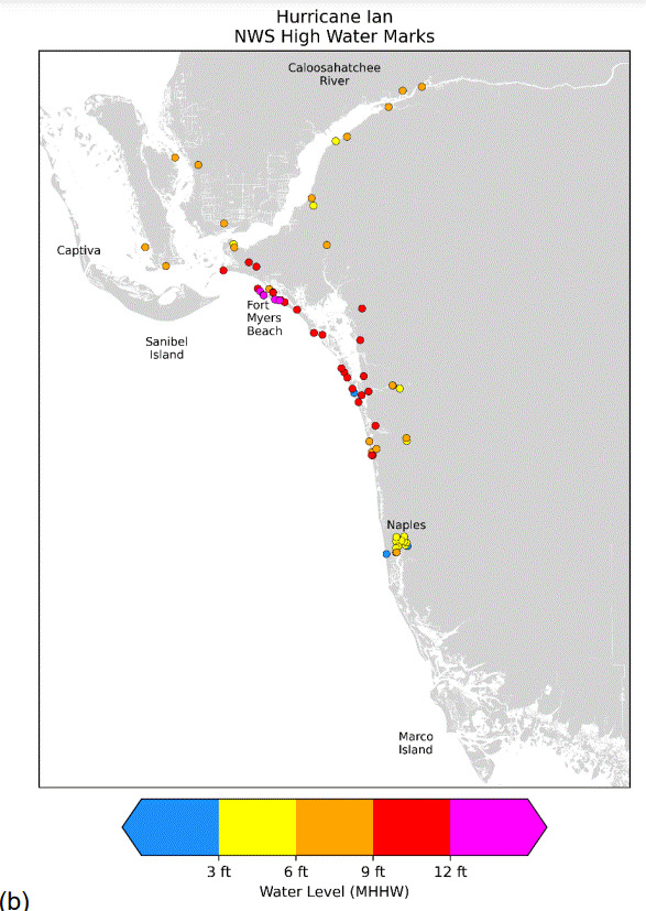
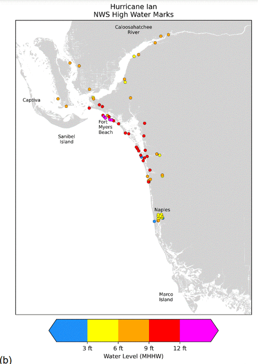
This graphic in the Ian TCR is from the NWS surveys and supplements the USGS sourced one you posted.
-
As you said, footage from Manasota Key, with collapsed structures:
-
Agreed on the complexities of storm surge. Just look at Ivan and Katrina for examples of very high west of landfall storm surges, while many other hurricanes do not have appreciable storm surges in that direction. Or Florence's Neuce River surge outperforming, or Dorian's surge on the backside of Hatteras. The storm surge forecasts are still the "weakest" part of the NHC products because of all the variables. I also want to note that easily verifiable facts are available to us this morning. Milton's storm surge was higher at both Ft. Myers and Naples than Helene's- significantly higher at Naples. Posts in the main thread seem to be speaking about the Tampa area only when comparing to Helene.
-
This banter thread and the main thread are indistinguishable at the moment. It’s always the case the morning after a hurricane landfall that the vacuum of information leads to lots of guess posts. What’s most amusing is the 10’ above normal water level trace near Sarasota, with Helene’s much lower height visible, juxtaposed to these confident posts that the storm surge underperformed.