

caviman2201
-
Posts
1,992 -
Joined
-
Last visited
Content Type
Profiles
Blogs
Forums
American Weather
Media Demo
Store
Gallery
Everything posted by caviman2201
-
The best part was I read it like it was a real update until I saw it... just about spit my drink everywhere... Where did that dude go anyway? Is he still reporting heavy standing water? Flash flooding?
-
one for the ages... losing my shit "Except fucking Georgetown" will be in every DC snow forecast from now until the end of time... its one of those 'board moments' that sticks
-
You're saying Mt. PSU and Mappyland find a way to jack? Say it ain't so...
-
Jan 15-16 Storm Threat Thread: The Return of Hope??
caviman2201 replied to stormtracker's topic in Mid Atlantic
Advisories just went up SW of the metros -
Jan 15-16 Storm Threat Thread: The Return of Hope??
caviman2201 replied to stormtracker's topic in Mid Atlantic
Are we actually on the precipice of a honest-to-god 2-4" run of the mill event? Did Lucy finally decide to let us kick the damn ball even if she deflated it so it didn't go very far?? Sent from my SM-S911U using Tapatalk -
Jan 15-16 Storm Threat Thread: The Return of Hope??
caviman2201 replied to stormtracker's topic in Mid Atlantic
I genuinely would lock up an area-wide 2" snowfall in the upper 20s Sent from my SM-S911U using Tapatalk -
Jan 15-16 Storm Threat Thread: The Return of Hope??
caviman2201 replied to stormtracker's topic in Mid Atlantic
Not sure if anyone's noticed but the mesos have been depicting a pretty good snow squall coming through tomorrow afternoon for several runs now Sent from my SM-S911U using Tapatalk -
Jan 15-16 Storm Threat Thread: The Return of Hope??
caviman2201 replied to stormtracker's topic in Mid Atlantic
It's been a while since we've seen a BWI jack... It won't happen but I'll take my win for a few hours! [emoji16] Sent from my SM-S911U using Tapatalk -
I feel like Walter in Money Pit when he finally loses the last little glimmer of hope and just starts laughing maniacally https://youtu.be/9CJ9EDtZ2p8?si=BayC48ScmEurWTxj
-
This is one of the greatest things I've ever read... I'm inspired to be reaped
-
Jan 15-16 Storm Threat Thread: Do we finally win or get Saltburned?
caviman2201 replied to H2O's topic in Mid Atlantic
You're in the wrong place... following your analogy this board is pretty much a liquor store with a bar in the back...- 425 replies
-
- 1
-

-
- jinx
- kiss of death
- (and 3 more)
-
Jan 15-16 Storm Threat Thread: Do we finally win or get Saltburned?
caviman2201 replied to H2O's topic in Mid Atlantic
You know you won't... addicts always come back. See you there.- 425 replies
-
- 2
-
-
- jinx
- kiss of death
- (and 3 more)
-
Jan 15-16 Storm Threat Thread: Do we finally win or get Saltburned?
caviman2201 replied to H2O's topic in Mid Atlantic
Whats your total since Jan 2022? Is it > 0"? -
Jan 15-16 Storm Threat Thread: Do we finally win or get Saltburned?
caviman2201 replied to H2O's topic in Mid Atlantic
Don't worry... Memphis and Little Rock are about to double their climo by being fringed... by being too far north... -
Jan 15-16 Storm Threat Thread: Do we finally win or get Saltburned?
caviman2201 replied to H2O's topic in Mid Atlantic
He honestly is... if you just simply went with whatever model showed no snow you'd pretty much be batting 1.000 over the past 2 years. Maybe it legit just doesn't snow here anymore under 750ft -
Jan 15-16 Storm Threat Thread: Do we finally win or get Saltburned?
caviman2201 replied to H2O's topic in Mid Atlantic
There's even people who... *gasp*... hate snow... -
Jan 15-16 Storm Threat Thread: Do we finally win or get Saltburned?
caviman2201 replied to H2O's topic in Mid Atlantic
At least Memphis gets a nice 6-10" event out of it consistently on every single model... -
Jan Medium/Long Range Disco 2: Total Obliteration is Coming
caviman2201 replied to Jebman's topic in Mid Atlantic
PSU is gonna be a while with the Ukie...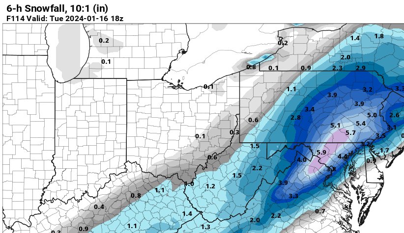
-
Jan Medium/Long Range Disco 2: Total Obliteration is Coming
caviman2201 replied to Jebman's topic in Mid Atlantic
My bar here really is low... I'll be satisfied with >1" of cold smoke... first 1" snow in 2 full years -
Jan Medium/Long Range Disco 2: Total Obliteration is Coming
caviman2201 replied to Jebman's topic in Mid Atlantic
Thats prob not a great trend...
-
Jan Medium/Long Range Disco 2: Total Obliteration is Coming
caviman2201 replied to Jebman's topic in Mid Atlantic
The mean QPF did shift SE significantly though from 00z though -
Jan Medium/Long Range Disco 2: Total Obliteration is Coming
caviman2201 replied to Jebman's topic in Mid Atlantic
EPS looks okay so far... -
Jan Medium/Long Range Disco 2: Total Obliteration is Coming
caviman2201 replied to Jebman's topic in Mid Atlantic
This seems like a very good chance for at least something for the whole area... and a massive improvement over 00z -
FWIW, the 12z GEFS surface low track is still ~75mi or so SE of the GFS op. Op seems to go from Norfolk to Cape May while GEFS goes Nags Head to 150mi E of Chincoteague
-
Jan Medium/Long Range Disco: Winter is coming
caviman2201 replied to stormtracker's topic in Mid Atlantic
Its still snowing at 144.... Edit: and at 147


