tnweathernut
-
Posts
4,927 -
Joined
-
Last visited
Content Type
Profiles
Blogs
Forums
American Weather
Media Demo
Store
Gallery
Everything posted by tnweathernut
-
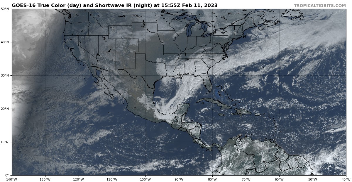
For east TN - Just noting we are in early ish February, with a near perfect track of a surface low, and a great 850 low pass incoming (including a deform band setting up somewhere in east TN) and we are leaning rain, even inside the deform. This satellite picture, knowing the date, should make your mouth water if you like snow. Just goes to show how poorly we do snow in the south. I'm still hopeful some in our region find flakes, but my hopes for a widespread snow event tapered about 36 hours ago.

-
If this turns out to be predominantly rain, the RGEM will have been the most consistent. The euro will turn out to be the biggest failure. JMO
-
Exactly. This is a big problem for our area. Initially we thought there would be an inverted trough across the southern apps. I don’t know where that thought has gone?
-
The biggest thing I don't like for anyone in east TN is the deform band sets up across the plateau and even into middle Tennessee. This isn't the way to get a big snow anywhere near the valley in east TN in light of a very marginal temperature profile. JMO
-
And the solution is poo for snow lovers. lol
-
 Eh, it would be ok........... Here in Tennessee if a donkey farts into the wind and it can throw things off when it comes to snow. As always, appreciate your input.
 -
I'll give Morristown this......................... 9 times out of 10 they will be right about snowfall in our region when playing it down. We (snow lovers) just have to hope this is a 1 of 10 situation.
-
Either the outlier or the leader........... I don't want to think about the latter. lol
-
Continues to trend deeper, further southwest, and more closed off at 500. A little slower and not as progressive and it would have looked very similar to the snowy southern app solutions, IMO.
-
Honestly, the presentation at 500 on numerous modeling has all the earmarks of a southern apps tree snapper.
-
It's always hard to extrapolate, but at 500 it's a touch deeper and sharper at 30. Would be surprised if it doesn't come in further west than 6z. Flow is definitely backing by 36. This one should be further west than 6z.
-
Not saying this one will happen, but our best snowstorms have occurred during the day when temps from 48-72 hours out were projected to be in the low 40's and what ended up happening was 33 and heavy snow. Also in very similar scenarios to this I have witnessed downsloping be a non-factor even though the flow on radar is directly over the mountains from SE to NW. Just a FWIW as we try and figure out if this potential system has legs.
-
I think everyone is out enjoying the 60+ degree weather. Lol 18 Z was definitely some serious eye candy for east TN and the southern apps.
-
Jan 31 - Feb 1 Ice Possibilities
tnweathernut replied to Holston_River_Rambler's topic in Tennessee Valley
Yes, but quicker to realize the sagging south of the final wave of precip where other modeling had it into east TN..... so I guess not great, but good on the back end. -
This one is the low hanging fruit, IMO. Close in, on multiple models, and has that "slider" look. Weak wave FTW........................ for someone.................. hopefully.
-
Fall/Winter Banter - Football, Basketball, Snowball?
tnweathernut replied to John1122's topic in Tennessee Valley
If not for a last second (gimmie) layup allowed by TN reserves at the end of the Georgia game.................. TN would have held GA to 39 points in a game of D1 college basketball. Man this D is good when they lock in. -
January 2023 Medium/Long Range Pattern Discussion Thread
tnweathernut replied to Carvers Gap's topic in Tennessee Valley
TBF - if we get an airmass like that and a 500 profile as indicated on the ensembles................. at some point there'd be a nasty snow/ice overrunning event from TX/OK through the TN/KY region.- 923 replies
-
- 1
-

-
- warm start
- cold
- (and 4 more)
-
January 2023 Medium/Long Range Pattern Discussion Thread
tnweathernut replied to Carvers Gap's topic in Tennessee Valley
Just have to keep systems coming across and at some point over a 7-10 day period........... something would likely be a hit.- 923 replies
-
- 2
-
-
- warm start
- cold
- (and 4 more)
-
January 2023 Medium/Long Range Pattern Discussion Thread
tnweathernut replied to Carvers Gap's topic in Tennessee Valley
Agree, I'd take my chances on wintery for someone in the mid-south with a surface low over NO.- 923 replies
-
- 1
-
-
- warm start
- cold
- (and 4 more)
-
January 2023 Medium/Long Range Pattern Discussion Thread
tnweathernut replied to Carvers Gap's topic in Tennessee Valley
Interesting. It has been rather insistent on suppression, but EVERY op run cuts. lol- 923 replies
-
- 1
-
-
- warm start
- cold
- (and 4 more)
-
January 2023 Medium/Long Range Pattern Discussion Thread
tnweathernut replied to Carvers Gap's topic in Tennessee Valley
As shown by the GEPS and GEFS, it's moving toward a gradient pattern. We would almost have to have a leader follower type setup where the first system drags colder air into the region for the second system to snow on us. The only negatives are we are south of the Ohio River so gradient patterns more often than not leave us on the wrong side of the tracks. Still, just takes one to make a memorable winter and we at least seem to be moving toward "opportunity"............. Any way you slice it, there should be plenty of moisture the next 2-3 weeks.- 923 replies
-
- 3
-
-
- warm start
- cold
- (and 4 more)
-
January 2023 Medium/Long Range Pattern Discussion Thread
tnweathernut replied to Carvers Gap's topic in Tennessee Valley
I'll add............... with that much cold potentially coming south it won't take much to see what is shown as a cutter with all rain now morph into a system that is more frozen (espcially on the front end). Cold air is pretty dense so if we can get it on the move, it may press much further south into coming disturbances than currently shown. I'm just interested in the pattern on a large scale currently. If we head where this is showing the lead time on a wintry system may not be much longer than 3-4 days.- 923 replies
-
- 3
-
-
- warm start
- cold
- (and 4 more)
-
January 2023 Medium/Long Range Pattern Discussion Thread
tnweathernut replied to Carvers Gap's topic in Tennessee Valley
Lots of chaos in the flow. I think the "general" look of a cutter or two pressing the boundary further south and east is more probable than not. As long as we have systems remaining in the flow, you'd think we'd (someone in the mid-south) luck up and hit something at some point the next 10-14 days.- 923 replies
-
- 2
-
-
- warm start
- cold
- (and 4 more)
-
January 2023 Medium/Long Range Pattern Discussion Thread
tnweathernut replied to Carvers Gap's topic in Tennessee Valley
We always have to walk a tightrope in the mid south……. We actually need some SE ridge. Will be fascinating to watch the next couple of weeks play out. Not worried about February yet, just looking for the next possible track. As you mentioned, we found an upslope event to track in the middle of a terrible pattern so it can happen……- 923 replies
-
- 1
-
-
- warm start
- cold
- (and 4 more)
-
January 2023 Medium/Long Range Pattern Discussion Thread
tnweathernut replied to Carvers Gap's topic in Tennessee Valley
With this much cold showing it won’t bother me to see a cutter. Even something that cuts west of the apps can be beneficial for our snow loving members in west (and maybe middle) TN. Wouldn’t be a bad thing to see something cut, drag the boundary deep into the SE and then the next wave have more cold to work with. All in all I’m encouraged for the last week of January.- 923 replies
-
- 2
-
-
- warm start
- cold
- (and 4 more)