tnweathernut
-
Posts
4,927 -
Joined
-
Last visited
Content Type
Profiles
Blogs
Forums
American Weather
Media Demo
Store
Gallery
Everything posted by tnweathernut
-

January 15th-17th 2024 Arctic Blast/Snow Event
tnweathernut replied to John1122's topic in Tennessee Valley
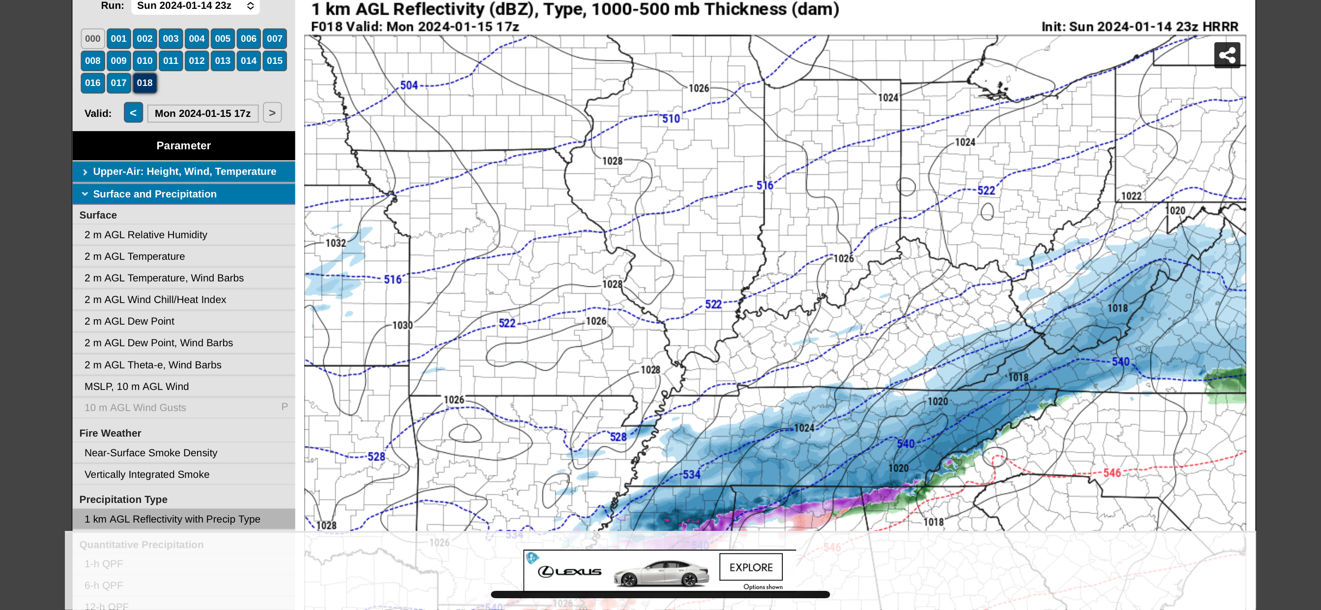
And this is the last hour of that model…. 17z. (12 noon). Most of what falls in east TN comes tomorrow after this time and into the evening. Still looks good to me.
-
January 15th-17th 2024 Arctic Blast/Snow Event
tnweathernut replied to John1122's topic in Tennessee Valley
It makes sense and I’ve mentioned it before, but when any storm involves overrunning, precip normally breaks out faster, is quicker, and the precip shield is often further north than modeled. I know you know this, just trying to piggy back off your comment to add to the discussion. -
January 15th-17th 2024 Arctic Blast/Snow Event
tnweathernut replied to John1122's topic in Tennessee Valley
It doesn’t make sense for the setup we have. I would think it’s likely wrong, but living where I live I never feel totally comfortable until the event has passed. -
January 15th-17th 2024 Arctic Blast/Snow Event
tnweathernut replied to John1122's topic in Tennessee Valley
It’s been a thorn for a couple of days now….. good test of it coming up. It’s definitely on an island. Hope the rest of the 18z models don’t follow. -
January 15th-17th 2024 Arctic Blast/Snow Event
tnweathernut replied to John1122's topic in Tennessee Valley
Thanks for mentioning surface conditions. Just checking the radar to the NAM, precip is breaking out faster than modeled. For everyone following, this is typical in overrunning situations. We can almost discard the globals at this point and go to the short range models. Even beyond that it's time to compare the actual surface to see if those short range models are initializing correct. Good luck everyone, hope the overrunning shield is a bit more robust than models indicate and hope we can keep any thermal issues down for those along the west side of the apps and especially for our brothers and sisters down toward Chattanooga. -
January 15th-17th 2024 Arctic Blast/Snow Event
tnweathernut replied to John1122's topic in Tennessee Valley
I never thought I’d live long enough to see it……. lol -
January 15th-17th 2024 Arctic Blast/Snow Event
tnweathernut replied to John1122's topic in Tennessee Valley
Thanks, that makes sense. Good to see your Jayhawks get the train back on the tracks today. -
January 15th-17th 2024 Arctic Blast/Snow Event
tnweathernut replied to John1122's topic in Tennessee Valley
We haven't discussed this much, but where does the FV3 fit into the equation? I honestly have NO clue. -
January 15th-17th 2024 Arctic Blast/Snow Event
tnweathernut replied to John1122's topic in Tennessee Valley
I agree this is the setup where most should score with little harm from thermal layers off a setup we have waited for ...... for a LONG time. It's not like we have a wrapped up negative tilt system coming at us. What do you think about the modeling consistently showing a warm nose/downslope up the western side of the apps into NE TN? I don't want to assume, but would guess you think this is overdone, solely based on the setup? -
January 15th-17th 2024 Arctic Blast/Snow Event
tnweathernut replied to John1122's topic in Tennessee Valley
RGEM gives southwest NC 1.2 inches of QPF. NAM gives at most .4 Pretty crazy difference -
January 15th-17th 2024 Arctic Blast/Snow Event
tnweathernut replied to John1122's topic in Tennessee Valley
I thought the RGEM and Euro both popped a less side low in SW NC. I figured this was the root cause of thermals getting screwed up in NE TN. -
January Medium-Long Range Discussion
tnweathernut replied to Holston_River_Rambler's topic in Tennessee Valley
Yeah, you are correct. I shouldn’t discount that possibility. From a progression standpoint front end stuff can happen before a changeover. -
January Medium-Long Range Discussion
tnweathernut replied to Holston_River_Rambler's topic in Tennessee Valley
FWIW. That one at the end of the run (if you look at 500) has no chance to be wintry….. should cut straight to the Midwest. Would make sense we relax after the next week. -
January 15th-17th 2024 Arctic Blast/Snow Event
tnweathernut replied to John1122's topic in Tennessee Valley
Euro is trolling us at this point. This system and the next. Poof. lol -
January 15th-17th 2024 Arctic Blast/Snow Event
tnweathernut replied to John1122's topic in Tennessee Valley
I feel attacked here……. lol -
January 15th-17th 2024 Arctic Blast/Snow Event
tnweathernut replied to John1122's topic in Tennessee Valley
I'm not sure who remembers AM Weather (really showing my age), but it was primarily an agricultural/aviation weather program I'd watch before school every morning in the winter time. This map is a fancy version of what you'd see on that program. I like it because it's old school. lol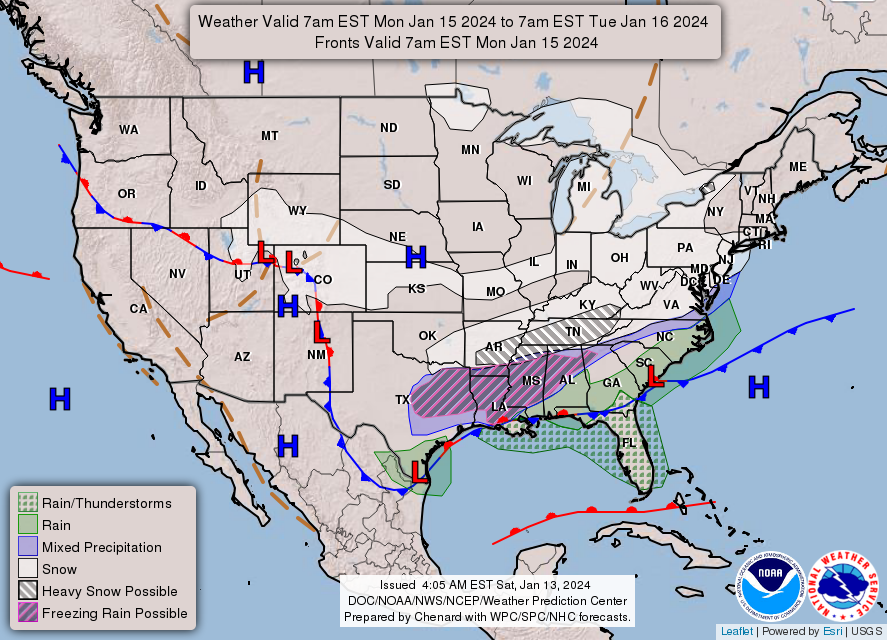
-
January 15th-17th 2024 Arctic Blast/Snow Event
tnweathernut replied to John1122's topic in Tennessee Valley
That was my understanding, but I'm not sure what lead time the person was talking about. If it was less than 24-36 hours that's a lot different than NAM had it nailed from 84. -
January 15th-17th 2024 Arctic Blast/Snow Event
tnweathernut replied to John1122's topic in Tennessee Valley
Yesterday, I was reading some on another forum covering the Chicago snow (can’t remember where I saw it), but was talking about the NAM being the only one not on board with a major snow). It ended up beating all the other models. It’s interesting because our system is projected so much further north than other modeling on the NAM. If it continues to stay north, will be fascinating to see if it can score a similar victory. I will say I have seen numerous overrunning setups in the past be further north and/or have that SW to NE trajectory vs the WSW to ENE trajectory once it starts developing. The good thing is, we don’t have to wait too much longer to find out. -
January 15th-17th 2024 Arctic Blast/Snow Event
tnweathernut replied to John1122's topic in Tennessee Valley
Those snow weenies in the mid Atlantic forum might be about to lose their minds seeing this thing just roll out to sea on the GFS. -
January 15th-17th 2024 Arctic Blast/Snow Event
tnweathernut replied to John1122's topic in Tennessee Valley
0z GFS really does complete the picture by giving everyone in TN something to cheer for. I see you Chattanooga with those 5 kuchera inches……. -
January 15th-17th 2024 Arctic Blast/Snow Event
tnweathernut replied to John1122's topic in Tennessee Valley
Pretty normal oscillations happening, IMO. In the overall scheme of things we see models waffling back and forth about 75-100 miles. Probably not unreasonable. We can all hope the overrunning is a bit more robust when we get to game time. -
January 15th-17th 2024 Arctic Blast/Snow Event
tnweathernut replied to John1122's topic in Tennessee Valley
It shouldn’t be, but I have learned to never discount it completely. -
January 15th-17th 2024 Arctic Blast/Snow Event
tnweathernut replied to John1122's topic in Tennessee Valley
The ICON seems to be putting less emphasis on the low in the Atlantic and more on the low in the gulf. I don’t think it really matters as it relates to the overrunning which spreads across the state, but I did find it interesting. -
January 15th-17th 2024 Arctic Blast/Snow Event
tnweathernut replied to John1122's topic in Tennessee Valley
Agree. I was waiting for the heavier snow bands on the icon to pivot through NE TN. For some reason they just dissipate. Not likely, but I suppose it could have been downslope aided. -
January 15th-17th 2024 Arctic Blast/Snow Event
tnweathernut replied to John1122's topic in Tennessee Valley
ICON spreading the overrunning love here at 0z