tnweathernut
-
Posts
4,927 -
Joined
-
Last visited
Content Type
Profiles
Blogs
Forums
American Weather
Media Demo
Store
Gallery
Everything posted by tnweathernut
-

January 2023 Medium/Long Range Pattern Discussion Thread
tnweathernut replied to Carvers Gap's topic in Tennessee Valley
I don’t want 20-25 BN departures….. let it go westward. I’m still getting pipe claims from the last arctic outbreak.- 923 replies
-
- 2
-

-
- warm start
- cold
- (and 4 more)
-
January 2023 Medium/Long Range Pattern Discussion Thread
tnweathernut replied to Carvers Gap's topic in Tennessee Valley
Looks pretty simple………Stronger low, warmer and west. Weaker low doesn’t necessarily mean less precipitation and would almost certainly mean a chance at a thermal profile more conducive to a winter event somewhere across a larger section of the mid-south.- 923 replies
-
- 1
-
-
- warm start
- cold
- (and 4 more)
-
Fall/Winter Banter - Football, Basketball, Snowball?
tnweathernut replied to John1122's topic in Tennessee Valley
This was the system at one point (briefly) modeled to phase and move due north and slow to a crawl I believe….. giving east TN and the apps a winter storm. Seems it happened, just in the western Atlantic vs the east coast. -
January 12-13 Severe and NWFS Event
tnweathernut replied to fountainguy97's topic in Tennessee Valley
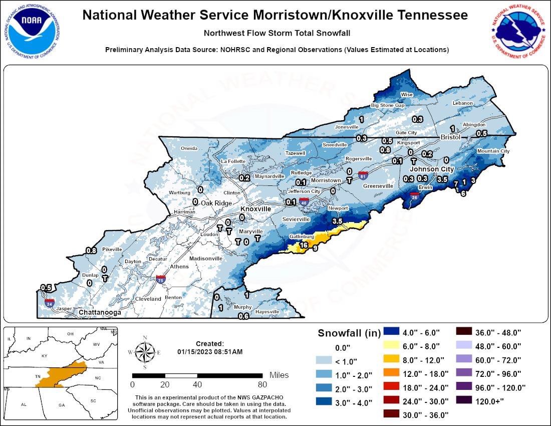
Not sure they have ever taken the care to make an accurate map……. Which is a shame because at some point these maps would be helpful with similar setups. -
January 12-13 Severe and NWFS Event
tnweathernut replied to fountainguy97's topic in Tennessee Valley
Putting a bow on this event.
-
January 2023 Medium/Long Range Pattern Discussion Thread
tnweathernut replied to Carvers Gap's topic in Tennessee Valley
I can’t remember the year, but it’s been fairly recent (last 10 to 12 years I think) when modeling was beginning to head in a great direction for winter lovers and then a SSW popped into view that ended up coming to fruition. Hype was off the charts and the SSW happened. Can kicking happened in near term and that short range pattern never materialized. Then the SSW affected the longer range too in sending the severe cold to the other side of the globe, leaving NA well above average I’m the heart of winter.- 923 replies
-
- 1
-
-
- warm start
- cold
- (and 4 more)
-
January 12-13 Severe and NWFS Event
tnweathernut replied to fountainguy97's topic in Tennessee Valley
Just down the road from you. I can attest, that band was fun. I was driving back from a clients and went through it. At my office (across from Food Lion), zilch. lol -
January 12-13 Severe and NWFS Event
tnweathernut replied to fountainguy97's topic in Tennessee Valley
Also can be said there is sometimes a burst or period of light snow can be achieved right around daybreak. At least I have noticed that here in the Tricities over the years. -
January 12-13 Severe and NWFS Event
tnweathernut replied to fountainguy97's topic in Tennessee Valley
Enjoy. Hope everyone who gets snow can enjoy it. Should be a decent one for the mountains and those above 2500. -
January 2023 Medium/Long Range Pattern Discussion Thread
tnweathernut replied to Carvers Gap's topic in Tennessee Valley
Hate to hear about your sick family member. Duke medical is about as good as it gets………. Hang in there.- 923 replies
-
- 7
-
-

-
- warm start
- cold
- (and 4 more)
-
January 2023 Medium/Long Range Pattern Discussion Thread
tnweathernut replied to Carvers Gap's topic in Tennessee Valley
Was probably a little early when looking at the possible threat for next weekend. Doesn't mean it can trend back to something positive, but overall............. I'm encouraged we will find winter in the mid-south like we do almost every other year. Just might have to wait an extra week or two before something materializes.- 923 replies
-
- 2
-
-
- warm start
- cold
- (and 4 more)
-
Fall/Winter Banter - Football, Basketball, Snowball?
tnweathernut replied to John1122's topic in Tennessee Valley
NW NC the new Buffalo of the south? lol -
Fall/Winter Banter - Football, Basketball, Snowball?
tnweathernut replied to John1122's topic in Tennessee Valley
Calling winter over in early January, after the best blocking we have seen develop in December in probably 20 years..................... is like calling the football game a loss after the FCS school goes down and kicks a FG to go up 3-0 against an SEC school with 11:42 left in the 1st quarter. -
Fall/Winter Banter - Football, Basketball, Snowball?
tnweathernut replied to John1122's topic in Tennessee Valley
I had a friend who laid some money on Ms State to be the first team to 10 points......... He had lost 17 of his last 20 bets. I texted him and told him this of course means TN opens with a 10-0 run. Didn't see 16-0, but he's been on a bad bad losing streak.... lol -
January 2023 Medium/Long Range Pattern Discussion Thread
tnweathernut replied to Carvers Gap's topic in Tennessee Valley
Which big snow? 98? If so, that was an ULL that just sat and spun over the mountains for hours upon hours............... marginal temps, in fact the NWS had us as 1 inch of snow, changing to rain and highs in the low 40's. Sat at 32-33 and wound up with 30+"- 923 replies
-
- 2
-
-
- warm start
- cold
- (and 4 more)
-
January 2023 Medium/Long Range Pattern Discussion Thread
tnweathernut replied to Carvers Gap's topic in Tennessee Valley
I was about to chime in with the same. I thought I remembered Larry proving this. I'm not yet convinced we see a SSW. Getting jostled around is much easier than a true splitting and wind reversal. I guess time will tell, but several of the stratospheric experts are also not on board with a split yet. I'm on record with not wanting a split. Too many unknowns and opportunities for failure. In the south we do failure well in relation to all things winter.- 923 replies
-
- 2
-
-
- warm start
- cold
- (and 4 more)
-
January 2023 Medium/Long Range Pattern Discussion Thread
tnweathernut replied to Carvers Gap's topic in Tennessee Valley
If you got a dusting last night, you got me beat........... lol I agree with the bold above ........One of the companies I represent is working toward 1,000 pipe break claims to show how unique this cold snap has been. They have less than 8% of the market share in the state of Tennessee. State Farm and Farm Bureau have around 50%. I can only imagine how many total water claims there will be from all the companies combined.- 923 replies
-
- 5
-
-
- warm start
- cold
- (and 4 more)
-
January 2023 Medium/Long Range Pattern Discussion Thread
tnweathernut replied to Carvers Gap's topic in Tennessee Valley
If we can manage to realize the lower heights in the Aleutians, it should teleconnect to a +PNA.- 923 replies
-
- 3
-
-
- warm start
- cold
- (and 4 more)
-
January 2023 Medium/Long Range Pattern Discussion Thread
tnweathernut replied to Carvers Gap's topic in Tennessee Valley
I'm beginning to see people in multiple places discuss a possible disruption of the stratospheric polar vortex. I'm going to say I don't want a split to occur. Let's jostle and move it around a bit, but let's keep it together. Biggest concern for a split means sweating things out and having (what seems to be) an 80% chance the cold filters to a place that hurts us more than helps us.- 923 replies
-
- 2
-
-
- warm start
- cold
- (and 4 more)
-
December 2022 Medium/Long Range Pattern Discussion Thread
tnweathernut replied to Carvers Gap's topic in Tennessee Valley
I grew up in Gallatin and went to a small church in Cottontown for a time in my youth. Congrats on the flakes and light accumulation. Always a bonus when it happens during the day. Being so cold, it's also nice to see every flake stick. Doesn't happen very often in Tennessee. Enjoy the snow!- 582 replies
-
- 1
-
-
- snow
- freezing rain
- (and 4 more)
-
December 2022 Medium/Long Range Pattern Discussion Thread
tnweathernut replied to Carvers Gap's topic in Tennessee Valley
Isn’t the precip shown for the 6 hours before (i e. not a snapshot representation of that specific time). Maybe the temperature map IS at that exact hour? Just guessing here……..- 582 replies
-
- 2
-
-
- snow
- freezing rain
- (and 4 more)
-
Historic Christmas Cold & maybe snow?! Dec 23rd-30th
tnweathernut replied to Wurbus's topic in Tennessee Valley
Agree, as shown it's a strengthening storm, but the precip shield doesn't match. With that track, you'd think the north/northwest precip shield would be a bit more robust. -
December 2022 Medium/Long Range Pattern Discussion Thread
tnweathernut replied to Carvers Gap's topic in Tennessee Valley
I remember that also…. Back when easternwx was in operation…- 582 replies
-
- 4
-
-
- snow
- freezing rain
- (and 4 more)
-
December 2022 Medium/Long Range Pattern Discussion Thread
tnweathernut replied to Carvers Gap's topic in Tennessee Valley
I guess there's always a need to change/tweak modeling (as the atmosphere is constantly changing), but I remember back in the day if the Euro and Ukie showed something at Day 4 to 5, you could almost lock it in............- 582 replies
-
- 8
-
-
- snow
- freezing rain
- (and 4 more)
-
December 2022 Medium/Long Range Pattern Discussion Thread
tnweathernut replied to Carvers Gap's topic in Tennessee Valley
Does it bother anyone else the American modeling (GFS) was way off for the system for late this week when it showed a major east coast snowstorm a few days ago, but was dead on for the low traversing the northern gulf region, expected to slide harmlessly beneath us the next 24-48 hours from about the same lead time out? lol- 582 replies
-
- 5
-

-
-
- snow
- freezing rain
- (and 4 more)