All Activity
- Past hour
-
CXY 90?
-
Looks like NWS is starting to ramp up the foothills. All of the models are now quite bullish on snowfall, and from what I can see from about 7k' and up...as well as the Palmer Divide. NWS is highlighting 8.5k' and up, and nothing highlighted for the Palmer Divide.
-
Sent from my motorola edge 5G UW (2021) using Tapatalk
-
All those years were good severe weather years here too...hmmmmmm
-

Severe Weather 4-25 through 4-28-24
Powerball replied to cheese007's topic in Central/Western States

-
They’ve had some ridiculous rad nights in the ASOS period. 21° 5/7/01 31° 6/18/03 40° 7/9/18
-

Central Pa. Spring 2024
Itstrainingtime replied to mahantango#1's topic in Upstate New York/Pennsylvania
MU 5 day projected highs beginning tomorrow through next Wednesday: 60, 82, 86, 86, 82. -
Central Pa. Spring 2024
Itstrainingtime replied to mahantango#1's topic in Upstate New York/Pennsylvania
That kinda sorta exactly matches what I said... -

Central Pa. Spring 2024
Mount Joy Snowman replied to mahantango#1's topic in Upstate New York/Pennsylvania
Here is what I have in my notes from back then.... Hurricane Sandy, worst storm to ever hit Jersey coast & NYC, 80-100mph winds, tons of flooding. We got only 3-6" of rain & 50-60mph gusts. Lancaster set record low pressure of ~960 mb as eye passed right over. Lowest pressure ever recorded for a North Atlantic storm. Storm dumped multiple feet of snow from NC mountains through Laurels. -
Central Pa. Spring 2024
Itstrainingtime replied to mahantango#1's topic in Upstate New York/Pennsylvania
Mow #8 coming in 6 hours. -
Central Pa. Spring 2024
Itstrainingtime replied to mahantango#1's topic in Upstate New York/Pennsylvania
I received 3.42" of rain from Sandy. My station in no way is able to record wind speeds accurately but I do know for certain that we had hours of 50mph+ winds. I had to take many detours the following morning to work, trying to find a road that wasn't closed due to downed trees and power lines. WAY more than a thunderstorm here. The main difference between Sandy and a thunderstorm was the duration of wind - sustained 40+ with gusts near 60 for several hours. - Today
-
wow haven't seen him in years. I know he had been ill
-
If we have westerly vs southerly flow on Mon it should be off to the races. Any downslope component/help and compressional heating near the sea breeze boundary will rocket us up E of the city.
-
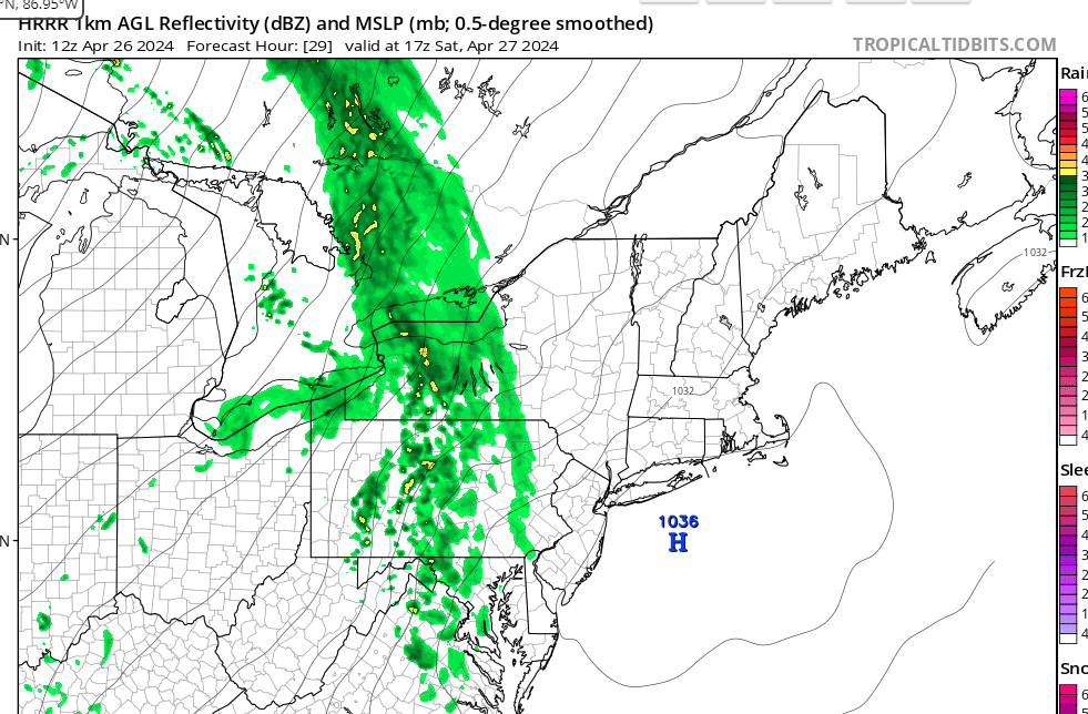
Here is the 12Z HRRR for tomorrow. It does get a bit warmer than 6Z with mid 50's vs. 40's and low 50's.
-
-
Is this how it's often hottest just after a cold front passes?
-
those fronts can give us a small boost from compressional heating
-
The water was too cold for them.
-
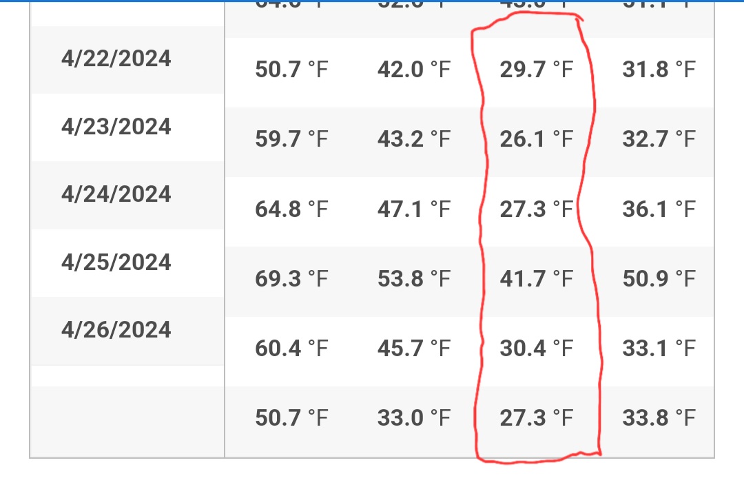
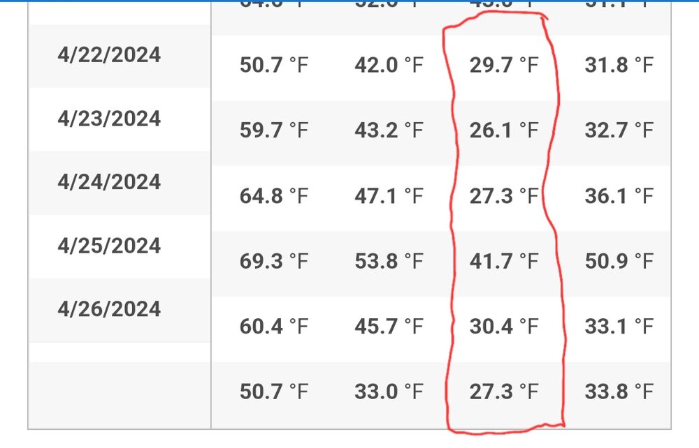
30.8. Trenton tied a record low of 33 that was from 1919.
-
Is that a steam plume in the distance rising from the dog shit in GInxy's yard?
-
Of course, while I was on vacation...no way to cover the fruit trees or other plants that decided to come up early...
-
Meso:s coming in a lot more wet at the last second? Sent from my SM-G970U using Tapatalk
-
My forecast is for cloudy skies with a 30% chance of a few showers later in the day high 59 with a low of 51 Sent from my SM-G970U using Tapatalk
-
Even areas of Long Island closer to the LIE could reach the 80s on Monday ahead of any backdoor cold front.

-
Maybe one last one tonight