All Activity
- Past hour
-

July 2025 Obs/Disco ... possible historic month for heat
kdxken replied to Typhoon Tip's topic in New England
88/67 was the high today at Sterling National. Little warm for my liking but who's to complain.
-

July 2025 Obs/Disco ... possible historic month for heat
Baroclinic Zone replied to Typhoon Tip's topic in New England
Hey another 90+ day in the 2025 book. 93F Thats 5 days this month now. Add that to 11 days in June. -

93L – “Inactive” Season Posting Check-In
Kevin Reilly replied to BarryStantonGBP's topic in Tropical Headquarters
If 93L comes off and can manage a further SW track before turning west then west-northwest then northwest it would stand a much better chance at development over water for a longer period of time. -

July 2025 Discussion-OBS - seasonable summer variability
nycwinter replied to wdrag's topic in New York City Metro
SnoSKi14 don't see that -

2025 Short Range Severe Weather Discussion
frostfern replied to Chicago Storm's topic in Lakes/Ohio Valley
Popups east of 131. WI complex shits the bed over the lake. More popups east of 131. Then it’s all whiffing south along I-80. Maybe I-94 gets some stratiform scraps. I-96 west of 131 desert. -

July 2025 Discussion-OBS - seasonable summer variability
uofmiami replied to wdrag's topic in New York City Metro
Looks to be a brief break of one day only, but it'll be welcomed for sure. -

July 2025 Obs/Disco ... possible historic month for heat
Torch Tiger replied to Typhoon Tip's topic in New England
Hopefully beyond my lifetime, but near-future, SSTs exceed mid-80's to even 90F for those Buzzards Bay type inlets, and so on! And SW, LI sound etc. -

July 2025 Obs/Disco ... possible historic month for heat
Dan76 replied to Typhoon Tip's topic in New England
Alex kintner disagrees. -

July 2025 Discussion-OBS - seasonable summer variability
Brian5671 replied to wdrag's topic in New York City Metro
Wow nice....that's a welcome change for a couple of days. -
The localized drought feedback is real here. Only spot where dewpoints have mixed down into the mid 50s despite a SSW wind.
-

93L – “Inactive” Season Posting Check-In
WxWatcher007 replied to BarryStantonGBP's topic in Tropical Headquarters
Yeah like the other models it has its moments. 93L has a pretty impressive look on IR and radar. Definitely aided by daytime heating but given its location I think this has a solid chance of development. Maybe 60%. -
July 2025 Discussion-OBS - seasonable summer variability
uofmiami replied to wdrag's topic in New York City Metro
.png.fee4d64d6e8c4ed9d1b82d9699f6c458.png)
-
July 2025 Obs/Disco ... possible historic month for heat
Torch Tiger replied to Typhoon Tip's topic in New England
hopefully more and more great whites too. Love this new climate! -

July 2025 Obs/Disco ... possible historic month for heat
Damage In Tolland replied to Typhoon Tip's topic in New England
And the coming Cane -
It has been quite humid and uncomfortable in my option. But I’m a couple miles off the lake. Have only had a couple days I could have the windows open since June 20th
-

July 2025 Obs/Disco ... possible historic month for heat
CoastalWx replied to Typhoon Tip's topic in New England
The water well south of block Island is 76. That rapidly warmed….probably warmer eddy that has migrated north. That will fuel the dews. -
July 2025 Obs/Disco ... possible historic month for heat
CoastalWx replied to Typhoon Tip's topic in New England
Lower dews inland and higher temps. BOS to HFD on south in the Amazon. -
July 2025 Discussion-OBS - seasonable summer variability
nycwinter replied to wdrag's topic in New York City Metro
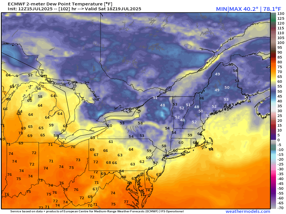
i was watching the weather on news 4 ny and they said dewpoint friday will be in the low 50's and saturday in the upper 40's is that true? -
2025 Short Range Severe Weather Discussion
frostfern replied to Chicago Storm's topic in Lakes/Ohio Valley
Bullshit again. -
SPC now has us in a marginal risk tomorrow and Thursday.
-
July 2025 Discussion-OBS - seasonable summer variability
Brian5671 replied to wdrag's topic in New York City Metro
of course the water warms, but it was below normal and now much above-that's an impressive swing. - Today
-
Guy, I don’t recall seeing you in the last few years here, but your style and the way you come across in your posts this year is often super combative. Chill out, you can still make your points and be less cringey/disagreeable. .
-

July 2025 Obs/Disco ... possible historic month for heat
rclab replied to Typhoon Tip's topic in New England
It should be quite a battle. As always ….
-
The stuff that builds to the West and you just know it will hit the mountains and go poof. It is the reason I have replaced most of my perennials with drought tolerant plants. My sedums have done amazing the last two years.
-

July 2025 Discussion-OBS - seasonable summer variability
psv88 replied to wdrag's topic in New York City Metro
Rain showers around all day today. Never cleared. High of 85. These showers only added up to 0.07, but the middle of the island had another cloudy and miserable day.