All Activity
- Past hour
-

Central Pa. Spring 2024
Itstrainingtime replied to mahantango#1's topic in Upstate New York/Pennsylvania
Temps on steroids now - 13 degree jump in the past 70 minutes. 73 and rising rapidly. -
Not far at all, maybe 3 miles as the crow flies. I recently saw it, didn’t know it was an official site. Good to know.
-

Mountain West Discussion- cool season '23-24
ValpoVike replied to mayjawintastawm's topic in Central/Western States
Final tally was 1.72” liquid. Really great moisture. - Today
-
64 now. If we do reach 80 it'll be late afternoon
-
Starting to wonder if we will reach the forecasted high of around 80 today, temps seem to be struggling a bit. We'll see.
-
0.73" overnight/this morning, so up to 6.30" for April now. Looking really lush out there now.
-
That’s be perfect - have a large concern e I’m in charge of and multiple walking and bus tours start at 11
-
What if it stops at 10:59 AM? Sent from my motorola edge 5G UW (2021) using Tapatalk
-
71°F down in Tyrone Sent from my motorola edge 5G UW (2021) using Tapatalk
-
I reallllly need it to not rain after 11 am Wednesday. It looks more and more like it might ugh
-
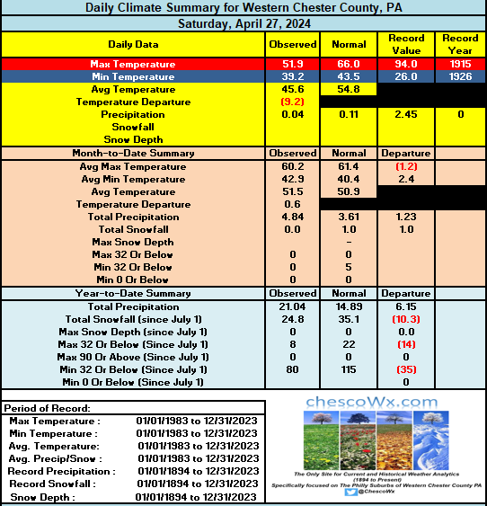
We have a chance to hit 80 degrees here in East Nantmeal for the first time since last September 9th. If not today for sure tomorrow. Mostly sunny both today and tomorrow before shower chances increase by Tuesday PM. Slightly cooler but still above normal temps will close out the work week. Chester County Records for today: High 92 degrees in Phoenixville (1915) / Low 26 degrees at Coatesville (1946) / Rain 2.00" at Devault (1952)
-

E PA/NJ/DE Spring 2024 OBS/Discussion
ChescoWx replied to Hurricane Agnes's topic in Philadelphia Region
We have a chance to hit 80 degrees here in East Nantmeal for the first time since last September 9th. If not today for sure tomorrow. Mostly sunny both today and tomorrow before shower chances increase by Tuesday PM. Slightly cooler but still above normal temps will close out the work week. Chester County Records for today: High 92 degrees in Phoenixville (1915) / Low 26 degrees at Coatesville (1946) / Rain 2.00" at Devault (1952)
-
Still at 56 a 11. It’s cold in the house - 63 inside.
-
Sun recently broke out here. Up to 60. Still 25 to go. Should be a good day for Mow 2 after the soaking yesterday.
-
62°F and sunny at 10:48. Sent from my motorola edge 5G UW (2021) using Tapatalk
-
Received .05" rainfall overnight. Water in the gauge is greenish yellow in color. Pollen season is here.
-
We are primed for a very strong La Niña event. If the IOD goes negative like the CFS monthly is suggesting, it’s really off to the races, i.e. 73-74, 88-89.
-
I think for the winter we might be looking at 1973-74 and 1983-84, warmer version of course. Which means maybe a couple of minor/moderate 4-6 inch events, pac dominated and lack of blocking. But I'm gung ho on a hot and dry summer (at least dry June and July-- August could be wetter depending on TC affecting our region, but dry otherwise.)
-
Way, way too early to think about winter, but just based on the current solar cycle, I would hedge very strongly against a -NAO winter right now. In the last 45 years (since 79-80), we have had 6 -NAO winters. All of them, without exception, occurred during a solar minimum, with a very low number of sunspots and low geomag activity. Definitely not a coincidence and HM wrote up a detailed explanation of why that is years ago. Wish I still had the link to it. But we have the exact 180 degree opposite of that solar setup this year
-

Texas 2024 Discussion/Observations
Ed, snow and hurricane fan replied to Stx_Thunder's topic in Central/Western States
Unfortunately I try to sleep at 1 am, but 12Z HRRR finally gets thunderstorms in Houston, with near 2500 J/Kg MLCape (after midnight!) and 40 knots effective shear. Enhanced Severe on 1300 SWODY1 gets as close to Houston as San Jacinto County. @Stx_Thunderhas access to t-storm probability maps. This begins the time of year when the Corpus Christi 12Z sounding has 4500 J/Kg surface cape but a 99F convective T. Amazing values of CAPE that will not be tapped by storms. -
55 at 10AM. 30+ degrees to go!
-
Rain will move in this evening, until then a cloudy, cool, breezy day. Will only manage mid/upper 30's for a high. Reached mid-60's yesterday with a few showers.
-
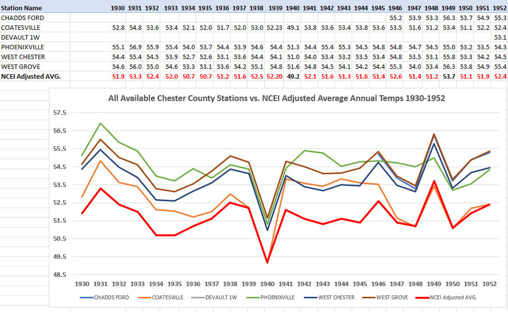
Well again Charlie tell us which stations are as you call them the "warmer parts of the county that were over-represented? they are in fact the only stations we have!! So how the heck are they over represented?? Below are in fact all of the available Chester County PA Stations during that time of greatest post hoc adjustments. While we had less stations we still have at least 4 NWS coop stations represented in the actual data. You will notice yet again that in 21 of these 23 years the NCEI Average temperatures was adjusted downward to below any and all stations in the county. The red numbers and line in the graph show the post hoc adjusted NCEI adjusted County average. Unsurprisingly Coatesville being the furthest NW station and with a bit more elevation ran coolest in most but not all years - but why then take the entire county down below even the coldest station during that time?
-
Hi @ForestHillWx- I see Rutgers just installed a new obs. network site in Chester. Anywhere near your location. Kind of nice to have an official site in your home town.

-
Cloudy/cool mornings are acceptable…but cloudy/cool afternoons? Nah, I’m good on that. I guess the next question will be if we can score some storms this week.