All Activity
- Past hour
-
One year we had a troll who reported rain in Georgetown during a snow event. It's now a running joke. (getting a wee bit tired imho but that's just me it gets the laughs.
-
Bingo. Every set up like this tends to favor the escarpment with a smaller screw zone just east. Typically sets up just east of 77.
-

The “I bring the mojo” Jan 30-Feb 1 potential winter storm
olafminesaw replied to lilj4425's topic in Southeastern States
He has a point, we are still in a relatively delicate position. However, spread will continue to narrow. If we can hold until Tommorow nights runs, we'll be feeling pretty good.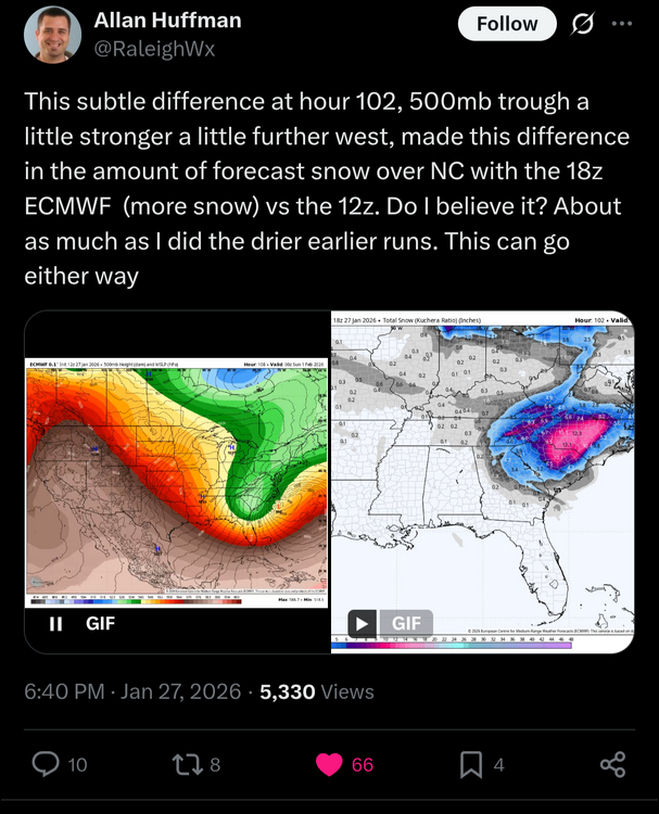
-
Got another day off and my chem exam postponed so I will be staying up for this 00z suite
-

The “I bring the mojo” Jan 30-Feb 1 potential winter storm
RockyKnob replied to lilj4425's topic in Southeastern States
Late January 1996 (heavy snow, with a bout of sleet in the middle of the event) and early February 1996 (sleet). Also had some random snow showers a week after the second storm. I lived in Greensboro at the time and the secondary streets in town were ice covered for three weeks. -
@Weather Willand I were holding the fort down this morning. He was mapping and I was shuffling people to the door. Anybody else who wants to leave stand in the door:

-
Jesus god Almighty the extended thread is a mess.
-

The “I bring the mojo” Jan 30-Feb 1 potential winter storm
BornAgain13 replied to lilj4425's topic in Southeastern States
90 members in the forum right now -
The inclusion of the middle name really adds credence, nice touch
-

The “I bring the mojo” Jan 30-Feb 1 potential winter storm
NorthHillsWx replied to lilj4425's topic in Southeastern States
That’s the good thing here, we’re well inside of where the last storm faded. This starts Friday night, that one was Saturday night/Sunday morning -
Why he say fuck me for
-

E PA/NJ/DE Winter 2025-26 Obs/Discussion
coastal front replied to LVblizzard's topic in Philadelphia Region
18z euro and eps was a huge improvement. Shows you how the smallest changes in tilt and timing have large differences in outcomes. Tilting a closed low 6 hours sooner while being 100+ hours out is not alot to ask. We love to see another day . . -

The “I bring the mojo” Jan 30-Feb 1 potential winter storm
KyleEverett replied to lilj4425's topic in Southeastern States
I can't let myself feel hope again. I've lived in the Metrolina area for a decade now and haven't had anything like this. I've seen so many modelled storms fizzle into nothing or Raleigh gets to have the fun. I'm still waiting for the rug pull. -

Possible coastal storm centered on Feb 1 2026.
ORH_wxman replied to Typhoon Tip's topic in New England
I have another analog https://www.meteo.psu.edu/ewall/NARR/1989/us0224.php#picture Ok, just had to get the childhood PTSD out of the way…I do think this one looks better than that one did. -
I had brunch with Louis W. Uccellini and he said I’d rather be over DC.
-
By the way, it was this far out for the last storm last weekend where the Euro (and the 18z one at that) shifted significantly NW.
-
 It did do something...I got 12 inches at my place in Wilson
 -
The “I bring the mojo” Jan 30-Feb 1 potential winter storm
olafminesaw replied to lilj4425's topic in Southeastern States
Listen, if we have to worry about sleet cutting into our totals, we're talking some pretty epic totals. -
Based on the link I sent, let's see if this checks out... Both the EPS and GEFS have the same weights. 1.2% for each individual member (1.2%*[50+30]=96%)... The GFS has a weight of 4%, so the ensemble snowfall contribution would be, 9 = 8 GEFS + 1 EPS SF_ens = 9 * 0.012 * 6" + 1 * 0.012 * 16" SF_ens ~ 1" NBM snowfall is SF_ens + 0.04*SF_GFS. I don't know what the GFS had for the city at 12z, but it could be calculated; NBM = 5.9" based on the map 5.9" = 1" + 0.04 * SF_GFS SF_GFS = 4.9"/0.04 = a very unrealistic answer... So something is off. Do you have the 6z totals? Mathematically, that's how the NBM (imo) calculates its mean.
-

The “I bring the mojo” Jan 30-Feb 1 potential winter storm
eyewall replied to lilj4425's topic in Southeastern States
That was the most heartbreaking event ever less than a year after the crusher. -

The “I bring the mojo” Jan 30-Feb 1 potential winter storm
NEGA_Dawg replied to lilj4425's topic in Southeastern States
Looks like my area is on the fringe for this. -
Persistent S/SSE swell contributing to a lot of that erosion. Waves parallel to the shore slowly etch away rather than push/pull sand. There's plenty of sand being stored on the bars. Need a swell direction change, and can't be a strong swell either.
-
The “I bring the mojo” Jan 30-Feb 1 potential winter storm
BornAgain13 replied to lilj4425's topic in Southeastern States
NAM should be interesting tonight -
The “I bring the mojo” Jan 30-Feb 1 potential winter storm
BornAgain13 replied to lilj4425's topic in Southeastern States
So is the Euro AI and 18z EPS an off run to? Lol -

The “I bring the mojo” Jan 30-Feb 1 potential winter storm
BooneWX replied to lilj4425's topic in Southeastern States
It’s not a thousand hours out either. This puppy is on our doorstep by Friday afternoon. 60 hrs roughly for western areas.


.thumb.jpeg.f5c6ba9d911ec96b3b124f8606aee58e.jpeg)