All Activity
- Past hour
-

December 2025 regional war/obs/disco thread
40/70 Benchmark replied to Torch Tiger's topic in New England
Heh....I was hoping that idea wouldn't work out, but.... -
You doing good friend. I used to be the one to bore everyone with all the 500 mb vorticity interactions/analysis. Now you can do it lol. It's largely what dictates our sensible weather at the surface as you are discovering. Good stuff!
-
Seems like any back side will be just light stuff. It needs to cool from 850 on down and I think light shit won’t cut it for more than a coating just N and W. We’ll see
-
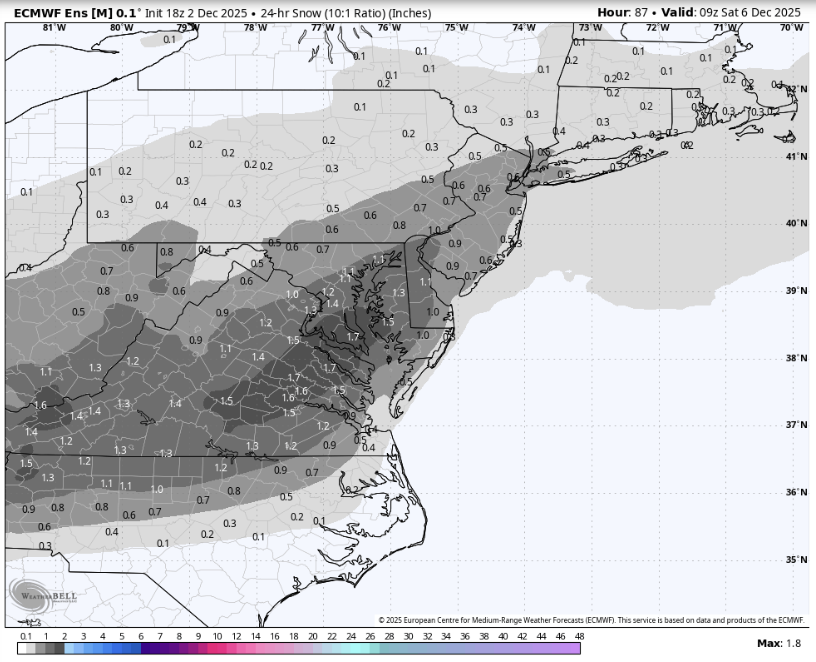
18z EPS shows an even stronger signal than 12z.
-
December 2025 regional war/obs/disco thread
40/70 Benchmark replied to Torch Tiger's topic in New England
Looks like me make through at least 12/9 without anything else noteworthy, so aside from this crap event, my second week idea looks to be working out....this is like 2007. We had one crap event on 12/4, then waited for the second week to really get going. -
Miserable time shoveling the driveway and a stretch of road in front of the driveway. Only took me a bit over an hour but it was moderate rain and I got soaked and the snow on the ground started to get water logged.
-
25.6° SN 7.7” Decent growth Latest core is 3.7”/0.28” Storm total so far is 7.7”/0.63”
-
To be honest the upper winds is where my knowledge gets confused as we went over how the jet forms (I can tell you why the jet increases on the northward heading side of an upper low and decreases when heading south) but didn't go over the practical effect on the surface. I'm currently trying to research it on my own but generally it confuses me as my intuition says that areas of lift should form where winds are accelerating in the upper atmosphere (as it induces lower level lift as air is pulled into the upper flow) yet I know from the 4 quadrant model that understand I have is flawed. Additionally, I would've expected that stronger upper winds generally encourages cyclogenesis and didn't consider that it could actually hurt consolidation (which admittedly does make sense). Basically, what upper wind profile would actually be conductive to forming a strong surface low pressure?
-
Gonna near an inch of rain soon. We QPF.
-
Looks like my 4-8" zone for the all snow areas will work out....I just didn't see the huge rates/amounts with that shitty SG.
-
3 1/2" here in the City per Western Mass News.
-
I don't remember seeing that type of aggressive warm nose in the soundings for FDK. Looked like for the first few hours, temps were around freezing all the way up.
-
29 degrees up here on top of Beech with the balcony covered and parking lot now white. Very nice! Hope we are able to see some heavier stuff later this week.
-
I guess you guys have stumbled into a W.W.A., which, of course, is something you should have had in October.
-

2025-2026 ENSO
brooklynwx99 replied to 40/70 Benchmark's topic in Weather Forecasting and Discussion
to be fair, most patterns are "hostile to KUs." they're rare and require some specific features -
Thank you! We finally got to the actual H5 Jet stream ageostrophic wind etc part of my course last month! Of course, it wasn't anything crazy but its given me just enough tools to begin identifying how the upper air connects to the surface and making predictions. That said, I'm very confident that this is very much a Dunning-Kruger effect where I know just enough to make broad forecasts and identify what I we need models to trend and make predictions from an earlier hour to but I am unable to "correct" model behavior as I just don't have the confidence (wait till Spring 2027 and Synoptic met for that) to do so. So with that said please feel free to correct any mistakes I make as it literally might save my grade! I also should of course mention that a lot of this knowledge was built through posts by you @psuhoffman @brooklynwx99 @high risk @WxUSAF@Terpeast @Bob Chill alongside the many other more occasional in depth breakdowns by our "on-event" posters. It's just this class has finally given me just enough to start synthesizing my own analyses so genuinely thank you.
-
Looks the "stinger" is forming out west. Looks potent but very narrow.
-
I need to go out and measure but I’m eyeballing 4”-5”. Very fluffy snow.
-

December 2025 regional war/obs/disco thread
Snowcrazed71 replied to Torch Tiger's topic in New England
Stop. Just stop posting. You could F$#k up a wet dream. Lol -

Central PA Fall Discussions and Obs
WmsptWx replied to ChescoWx's topic in Upstate New York/Pennsylvania
The five recruits are all going to flip and when the Portal opens, everyone is leaving. Hiring Smith is the only thing that may prevent all of that from happening. -
0.95” - nice to see the QPF do well
-
So don’t read the thread
-
18z gfs shows threats. All I would care about.
-
we just had a 25 page thread for sleet and cold rain. It’s okay to start a thread for this potential
-
I mean the atmospheric models are already showing red flags, which have been pointed out on this very page.