All Activity
- Past hour
-

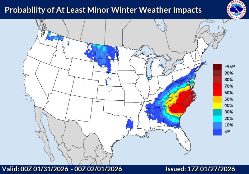
The “I bring the mojo” Jan 30-Feb 1 potential winter storm
SouthboundYank replied to lilj4425's topic in Southeastern States
VERY valid advice here. While I posted a somewhat common sense intepretation from Gemini's interpretation from WeatherNext 2.0 earlier....when I ask the same of Gemini on my GoogleTV, it tells me that highs on Sat/Sun this weekend are going to be in the 50s, with lows in low 40s, with NO precipitation. So yeah, always confirm and double-check AI interpretations...the hallucinations are very real. -
We will learn alot about the models as to how this plays out
-
Baltimore County is closed tomorrow (Wednesday). The 2 hours late may be for Thursday
-
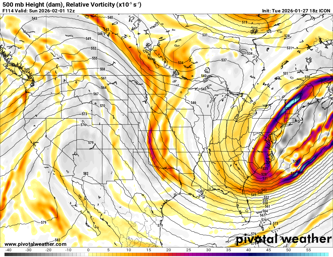
FWIW... the ICON ensemble has a noticeably larger number of lows along the coast compared to 12z. Not sure it follows the op's idea of splitting the energy.
-
the #1 rule of looking at model trends: The trends I like will continue. The trends I don't like are flukes.
-

The “I bring the mojo” Jan 30-Feb 1 potential winter storm
BornAgain13 replied to lilj4425's topic in Southeastern States
Its the ICON, we toss. -
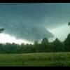
That is an impressive squall... wonder if there will be any thunder with it. Hopefully it strengthens as it moves east
-

The “I bring the mojo” Jan 30-Feb 1 potential winter storm
StantonParkHoya replied to lilj4425's topic in Southeastern States
ICON really not good -

The “I bring the mojo” Jan 30-Feb 1 potential winter storm
Orange county replied to lilj4425's topic in Southeastern States
Nice for them to talk to me like this -

E PA/NJ/DE Winter 2025-26 Obs/Discussion
Kevin Reilly replied to LVblizzard's topic in Philadelphia Region
I’m in until 12z Thursday think we may see some changes at this point coastal sections could still be in trouble due to a strong onshore flow. I cannot ignore what the gfs was selling last week 977 mb east of NJ then lose it only for the Euro to pick it up 18z to 6z Sunday to Monday then lose it. still a lot of waffling I’d like to see play out either way next 25-36 hours I think we will know. Therefore yes I’m in! -

E PA/NJ/DE Winter 2025-26 Obs/Discussion
Newman replied to LVblizzard's topic in Philadelphia Region
A blend of the 12z Allen Iversons (AIs) would put I-95 on the western fringe. -
The “I bring the mojo” Jan 30-Feb 1 potential winter storm
BornAgain13 replied to lilj4425's topic in Southeastern States
Icon didnt close off soon enough. -
The “I bring the mojo” Jan 30-Feb 1 potential winter storm
UpstateSCBud replied to lilj4425's topic in Southeastern States
-
Kind of weird. It somewhat splits towards the end of the run which is very unlike what we've seen on other models

-
The “I bring the mojo” Jan 30-Feb 1 potential winter storm
BornAgain13 replied to lilj4425's topic in Southeastern States
18z ICON similar to 12z maybe a little west but its splotchy with the precip -
huh, flakes in the air. Wasn’t expecting that today. Definitely a deep winter vibe this week.
-

The “I bring the mojo” Jan 30-Feb 1 potential winter storm
ecrugger replied to lilj4425's topic in Southeastern States
Oh, she'd definitely understand. She's a level headed kid. I'm just torn because I want to hang out with her! -

The “I bring the mojo” Jan 30-Feb 1 potential winter storm
Snowncanes replied to lilj4425's topic in Southeastern States
Whiff again at the surface. Need a little less interaction with the 50/50 low in order for it to close off I think. Trended west early on, Didnt close off. Pick your poison -
yea result is even worse that 12z
-
Cecil County schools will be virtual Wednesday Baltimore County 2 hours late
-

E PA/NJ/DE Winter 2025-26 Obs/Discussion
Hurricane Agnes replied to LVblizzard's topic in Philadelphia Region
I was out around that time finishing up getting the snow off the roof of the car (a SUV) and just as I was about to come in, there were some flurries. Currently overcast and 22 with dp 10. Had a low off 11 and high of 23. (have avoided the midrange model freakout but will try to start checking the runs tomorrow ) -

E PA/NJ/DE Winter 2025-26 Obs/Discussion
Ralph Wiggum replied to LVblizzard's topic in Philadelphia Region
Noted. In this case, Im in. -
Icon isn't any better. It extends further west, but the energy stays strung out instead of forming a closed low.
-

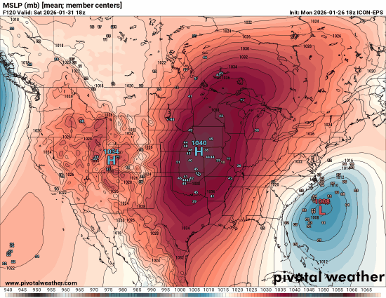
Possible coastal storm centered on Feb 1 2026.
MegaMike replied to Typhoon Tip's topic in New England
The 13z NBM has a 12-18" mean contour for SE MA (looks similar to the map DIT posted). According to dat' link (https://vlab.noaa.gov/documents/6609493/32850490/CONUS_SNOICEACCUM.pdf), snowfall values at 84hr+ are calculated from 30 GEFS members, 50 ECMWF members, and the GFS. Needless to say, some individual members still support this event. 12z GEFS fcst hr 138: 12z EPS fcst hr 138 (last available hour at the moment): -
NWS for Saturday night in Frederick area: Saturday Night A chance of snow. Mostly cloudy, with a low around 11. Chance of precipitation is DC Saturday A chance of snow after 1pm. Mostly cloudy, with a high near 19. Chance of precipitation is 30%. Saturday Night A chance of snow. Mostly cloudy, with a low around 13. Chance of precipitation is 40%.