All Activity
- Past hour
-

December 2025 regional war/obs/disco thread
weatherwiz replied to Torch Tiger's topic in New England
The real problem I think would be if the strong blocking persists. We would probably get chances as the block is materializing and then we'd want to hope for the block to relax or break down a bit and that could come with some chances. But if a big block materializes and becomes established...then we may be screwed -
Meanwhile euro had a nice SWFE. I’d hit it.
-

Central PA Winter 25/26 Discussion and Obs
AccuChris replied to MAG5035's topic in Upstate New York/Pennsylvania
HRRR showing a nasty “squall line” tomorrow morning . -
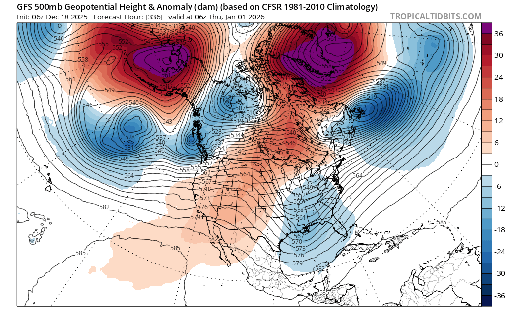
Big blocking would help out going into January imho. Most guidance keeps wanting -PNA and a SE ridge. If you overlay strong blocking, then it reduces the chances of cutters and torches. Lot of uncertainty though with the blocking. But it’s def been increasing on all guidance.
-

Central PA Winter 25/26 Discussion and Obs
pasnownut replied to MAG5035's topic in Upstate New York/Pennsylvania
for the record keepers. 19-22 was the "runnin" average on way to Etown. which was at 25 -
(002).thumb.png.6e3d9d46bca5fe41aab7a74871dd8af8.png)
Central PA Winter 25/26 Discussion and Obs
ChescoWx replied to MAG5035's topic in Upstate New York/Pennsylvania
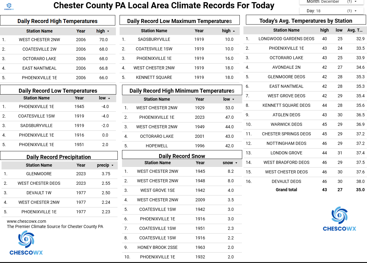
Today will be our mildest day since the day before Thanksgiving with highs in the mid to upper 40's. Rain heavy at times arrives after midnight and continues into tomorrow morning. Combined with the melting snow and ice we could see some local flooding. Temperatures will rise into the low 50's toward morning before a strong cold front passes through with maybe a thunderstorm and then temperatures crash tomorrow during the day reaching near freezing by 5pm. There is a wind advisory in effect tonight into tomorrow so watch for some power outtages in the usual spots across the county. We then look to see temperatures bouncing below normal on Saturday, Monday and near normal Sunday, Tuesday and Christmas Eve. Our next chance of some snow or rain looks possible by Tuesday.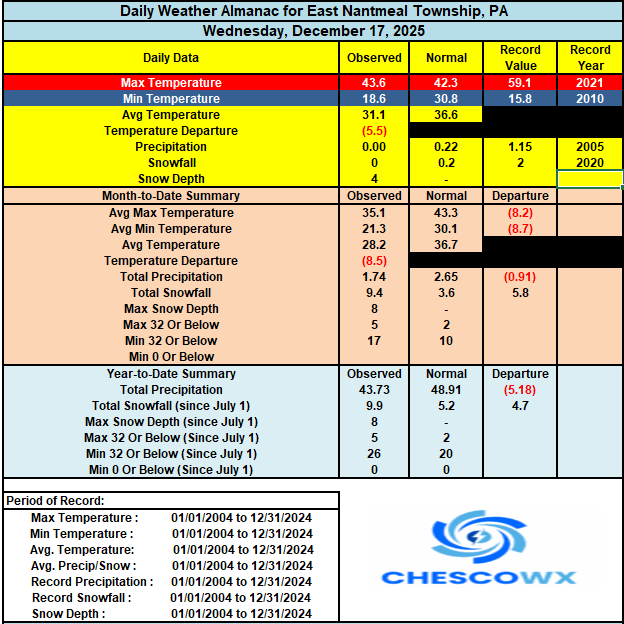
-
E PA/NJ/DE Winter 2025-26 Obs/Discussion
ChescoWx replied to LVblizzard's topic in Philadelphia Region
Today will be our mildest day since the day before Thanksgiving with highs in the mid to upper 40's. Rain heavy at times arrives after midnight and continues into tomorrow morning. Combined with the melting snow and ice we could see some local flooding. Temperatures will rise into the low 50's toward morning before a strong cold front passes through with maybe a thunderstorm and then temperatures crash tomorrow during the day reaching near freezing by 5pm. There is a wind advisory in effect tonight into tomorrow so watch for some power outtages in the usual spots across the county. We then look to see temperatures bouncing below normal on Saturday, Monday and near normal Sunday, Tuesday and Christmas Eve. Our next chance of some snow or rain looks possible by Tuesday.
-
Central PA Winter 25/26 Discussion and Obs
pasnownut replied to MAG5035's topic in Upstate New York/Pennsylvania
absolutely. This has been a very nice December, no matter how it ends, and it doesnt look torchy terrible. Yeah we'll have to suffer a bit, but thats normal and part of the gig. Have a good day all. -
Yep, best way to extinguish a torch is throw some H2O on it.
-

Central PA Winter 25/26 Discussion and Obs
Itstrainingtime replied to MAG5035's topic in Upstate New York/Pennsylvania
Low this morning of 22 which was far lower than I expected after the events of last evening. I had some sort of inversion that sent my temp from 30.2 at 8pm up to 36.8 at 9pm. Temp plateaued there and was still at 35.1 at midnight. Was able to shave off 13 degrees during the early morning hours. -
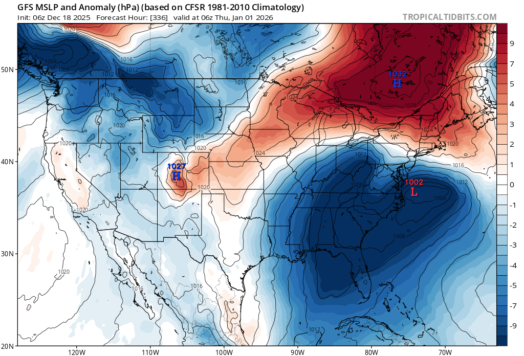
Classic setup with strong surface HP locked in right where we want it because of the block.

-
Central PA Winter 25/26 Discussion and Obs
pasnownut replied to MAG5035's topic in Upstate New York/Pennsylvania
17 lowest i saw on car digi outside of brunnerville this AM. as i stated the other day, pattern twds eoy looks to be flattening, w/ AO/NAO both headed into - territory. PNA/EPO also - which says zonal baby. As blizz suggested, which side of the boundary we are on is the challenge. OP's seem to be catchin onto the regime shift and hopefully adjust to better looks. How long does it last...million$$ question. Lastly the wonky evolution early in the new year is rather fun to see, and a couple models showing wonkiness at varying levels, but we get snow, so I'm in for the ride no matter if we derail or not. -

Central PA Winter 25/26 Discussion and Obs
Mount Joy Snowman replied to MAG5035's topic in Upstate New York/Pennsylvania
Low of 26. Going to enjoy my last day of full snow coverage before the heavy rains hit tonight. Still a beautiful scene out there. Quite a memorable start to December. -
December 2025 regional war/obs/disco thread
weatherwiz replied to Torch Tiger's topic in New England
I love the euro op phasing of a TPV piece with southern stream energy across the Carolinas towards the end of the run lol -
Fwiw, 6z AIGFS has essentially the same threat as the Gfs, just a bit more "realistic"?
.thumb.png.980dfbbe206e7db5e553472cce25398e.png)
-

Central PA Winter 25/26 Discussion and Obs
paweather replied to MAG5035's topic in Upstate New York/Pennsylvania
Looks good Blizz. Hope we can capitalize on one or both of these in the next few weeks -

December 2025 regional war/obs/disco thread
The 4 Seasons replied to Torch Tiger's topic in New England
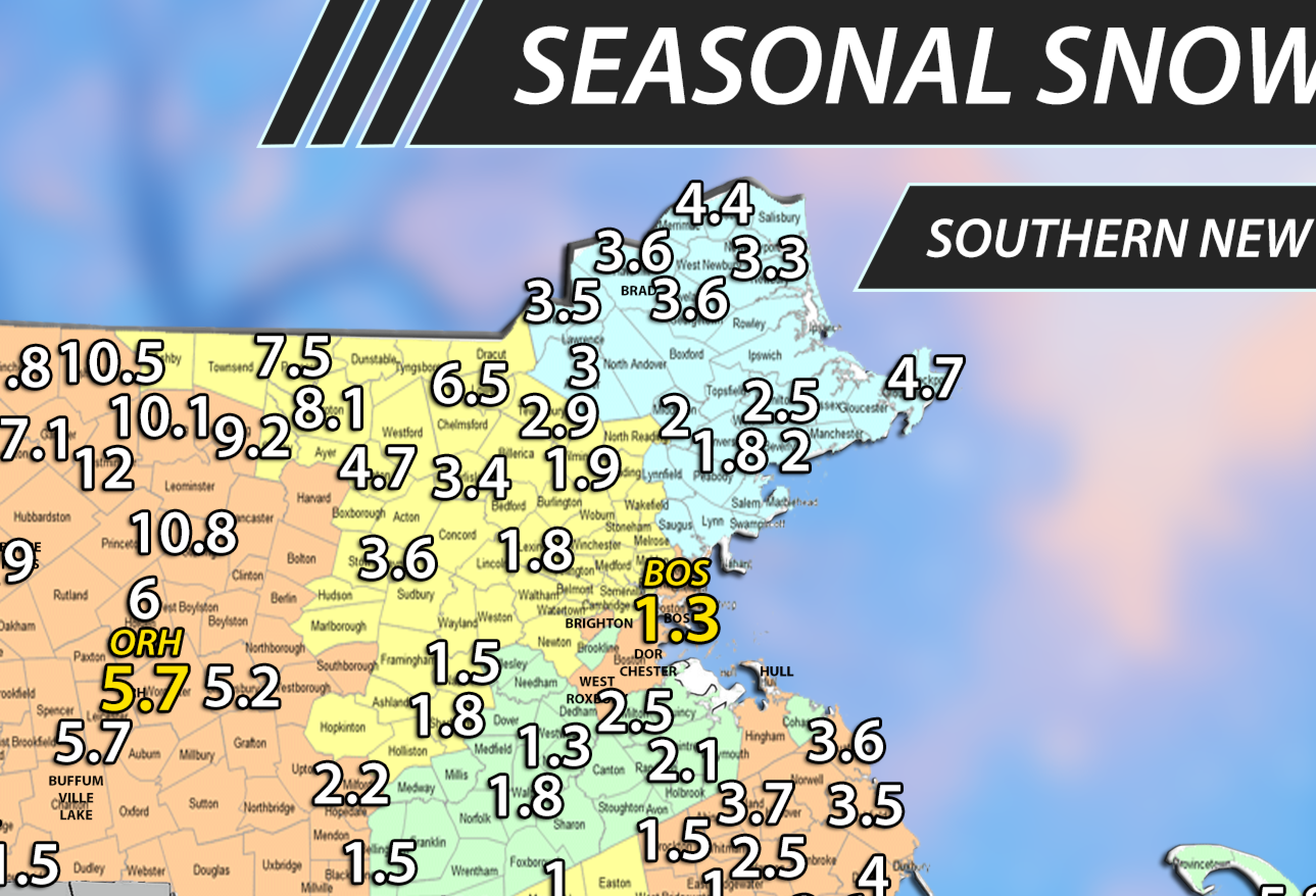
doesnt fit, got 1.7" already in killingly from cocorahs so youll have to settle for that lmao updated -

December 2025 regional war/obs/disco thread
brooklynwx99 replied to Torch Tiger's topic in New England
one of the only things that can really alleviate a shit Pacific with -WPO is a strong west based -NAO… just shunts everything west and changes the Pacific alignment -
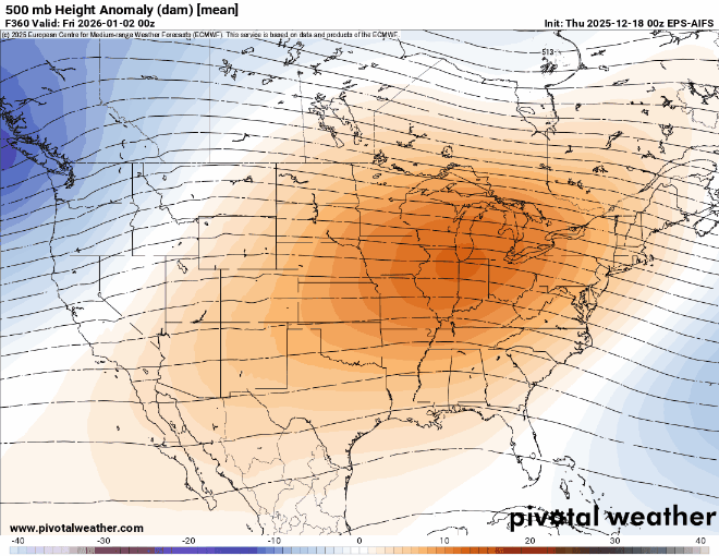
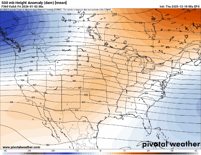
GFS is further expansive east with the ridge and the Euro had a cutoff building NE to SW in the Dec 30 period.
-

December 2025 regional war/obs/disco thread
Kitz Craver replied to Torch Tiger's topic in New England
Just took a look at the 0z EURO, that’s a pretty wild run -
Do you have to let it?
-
December 2025 regional war/obs/disco thread
The 4 Seasons replied to Torch Tiger's topic in New England
oh i put you at 3.5" just based on my quick thinking from last storm you said 1 and the previous 2.5, so i got 3.5 but i can quickly fix that. I have a town overlay so i put everyone in the middle of the town unless i know exactly where they are. ill change it to 3.8
-
This will be a good test for the AIFS EPS coming up since it matches the composite more than the EPS with the further east ridge axis.
-

December 2025 regional war/obs/disco thread
Sey-Mour Snow replied to Torch Tiger's topic in New England
Let’s get a Jan 2016 repeat -

December 2025 regional war/obs/disco thread
40/70 Benchmark replied to Torch Tiger's topic in New England
No question this eclipses the late 80's-early 90's stretch if this season sucks...they are like Brady and Mahomes for suckage spell GOATs right now....but this year would put 2020s ahead.


.png.18456cb895c557208cd91360460b481c.png)