All Activity
- Past hour
-

The “I bring the mojo” Jan 30-Feb 1 potential winter storm
CentralNC replied to lilj4425's topic in Southeastern States
I highly doubt the coastal plain would be the screw zone this time. Think western piedmont and foothills is where we need to be MOST wary of that. Coastals always have a screw zone somewhere on the NW flank. Always. -

The “I bring the mojo” Jan 30-Feb 1 potential winter storm
NorthHillsWx replied to lilj4425's topic in Southeastern States
Gotta say, that coastal plain dry slot is concerning. One of these analog storms, cannot remember which, did that bad over central NC. Starting to see it on most modeling. Could really screw someone in this setup as the coastal takes over -
URGENT - WINTER WEATHER MESSAGE National Weather Service Wakefield VA 238 AM EST Thu Jan 29 2026 NCZ012>017-030>032-102-VAZ092-093-095>098-100-524-525-291700- /O.NEW.KAKQ.WS.A.0002.260131T0600Z-260201T2100Z/ Northampton-Hertford-Gates-Pasquotank-Camden-Western Currituck- Bertie-Chowan-Perquimans-Eastern Currituck-Southampton-Isle of Wight-Norfolk/Portsmouth-Suffolk-Chesapeake-Virginia Beach- Northampton-Newport News-Hampton/Poquoson- 238 AM EST Thu Jan 29 2026 ...WINTER STORM WATCH IN EFFECT FROM LATE FRIDAY NIGHT THROUGH SUNDAY AFTERNOON... * WHAT...Heavy snow possible. Total snow accumulations between 8 and 15 inches possible. Winds could gust as high as 50 to 60 mph along the coast. * WHERE...Portions of northeast North Carolina and eastern and southeast Virginia. * WHEN...From late Friday night through Sunday afternoon. * IMPACTS...Whiteout conditions are possible and may make travel treacherous and potentially life-threatening. Travel could be very difficult to impossible. Strong winds could cause tree damage. PRECAUTIONARY/PREPAREDNESS ACTIONS... Monitor the latest forecasts for updates on this situation.
-

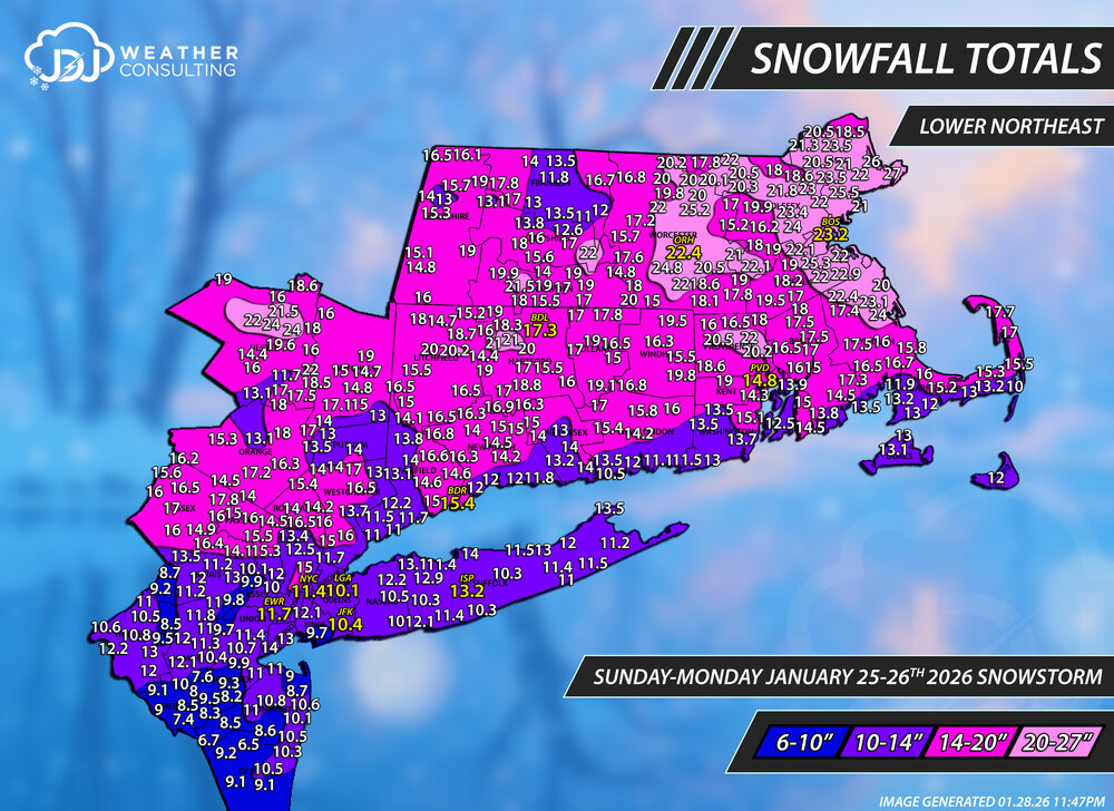
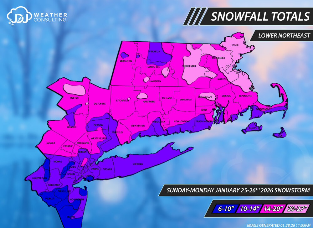
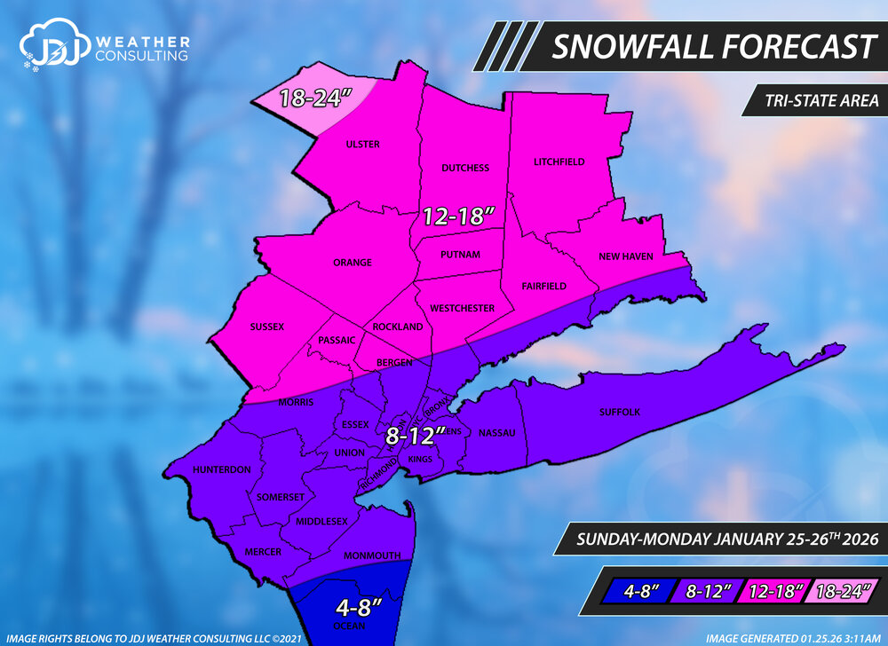
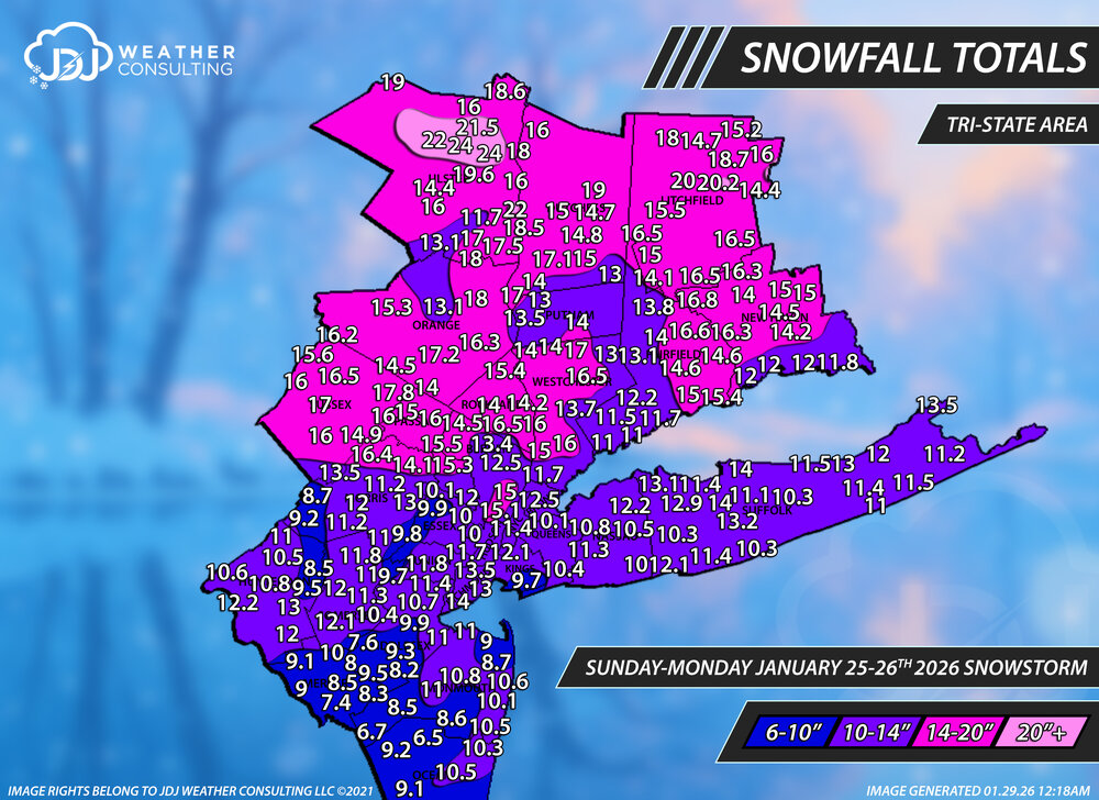
January 25-26th, 2026 Final Storm Totals
The 4 Seasons replied to The 4 Seasons's topic in New England
I sorted all the reports and weeded out all the ones that were early or before it was over and didn't include Monday. Apparently thats final from cocorahs. But it does seem too low, so i tossed it. not in the final map.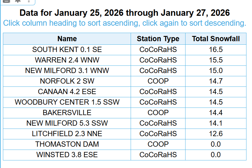
-
Huh. That's what my wife calls me. Now I get where she got it from.
-
Final snowfall totals for the Jan 25-26th Snowstorm. This was a huge undertaking that i've been working on all week sifting through over 1,000 reports. Thank you to everyone who sent me a report or tagged me. I tried to use most of them when i could but some just couldn't fit or multiples for a single town/area. This will be up in the archive once surface and upper level maps come out. The forecast for this was solid overall, though a bit on the conservative side across the board, but still most major cities fell with original 8-12" range across NYC/NJ and LI. I changed the ranges to 6-10/10-14/14-20/20+ to be more fitting with the snowfall totals and so there was less holes/bubbles. These maps are now up on our site in the Winter 25-26 page. https://www.jdjweatherconsulting.com/winter-25-26 Snowfall Totals Final Forecast
-
Figures that the western valley counties like Anderson wouldn't be in it. I'd love 1 good snow before spring. Hope there's still some room for a shift.
-

The “I bring the mojo” Jan 30-Feb 1 potential winter storm
timnc910 replied to lilj4425's topic in Southeastern States
Here are the 06z icon totals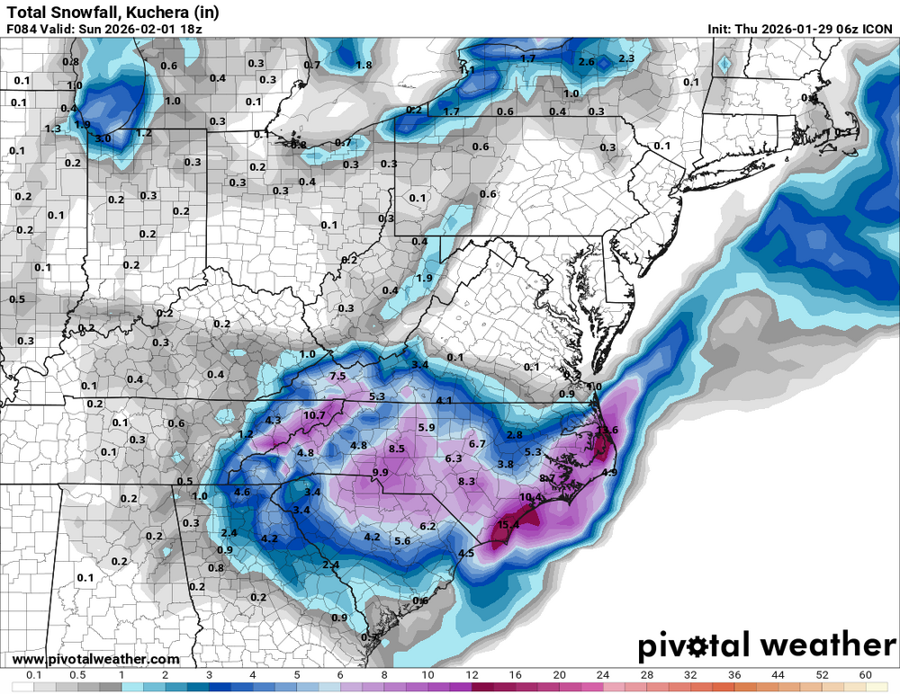
-

The “I bring the mojo” Jan 30-Feb 1 potential winter storm
BornAgain13 replied to lilj4425's topic in Southeastern States
6z ICON not quite as good as 0z but not a huge difference. -

The “I bring the mojo” Jan 30-Feb 1 potential winter storm
JoshM replied to lilj4425's topic in Southeastern States
Well, the euro has a storm for Thursday and Friday next week -
Rabun-Habersham-Stephens-Franklin-Hart-Elbert-Avery-Alexander- Iredell-Davie-Madison-Yancey-Mitchell-Swain-Haywood-Buncombe- Catawba-Rowan-Graham-Northern Jackson-Macon-Southern Jackson- Transylvania-Henderson-Cleveland-Lincoln-Gaston-Mecklenburg- Cabarrus-Union-Caldwell Mountains-Greater Caldwell-Burke Mountains-Greater Burke-McDowell Mountains-Eastern McDowell- Rutherford Mountains-Greater Rutherford-Polk Mountains-Eastern Polk-Cherokee-York-Anderson-Abbeville-Laurens-Union-Chester- Greenwood-Oconee Mountains-Pickens Mountains-Greenville Mountains- Greater Oconee-Greater Pickens-Central Greenville-Southern Greenville-Northern Spartanburg-Southern Spartanburg- Including the cities of Poplar, Fountain Inn, Tuxedo, Tuckasegee, Gastonia, Westminster, Gumlog, Greenville, Clemson, Newton, Crouse, Anderson, Concord, Abbeville, Franklin Springs, Pine Mountain, East Flat Rock, Marion, Hendersonville, Dysartsville, Boydville, Cullowhee, Kannapolis, Oakway, Huntersville, Walhalla, Chimney Rock State Park, Clinton, Royston, Salisbury, Lavonia, Stecoah, Valdese, Robbinsville, Fingerville, Hot Springs, Trinity, Newland, Mooresville, Fletcher, Old Fort, Hickory, Glassy Mountain, Canon, Marshall, Taylorsville, Brevard, Blackstock, Rock Hill, Mocksville, Stony Point, Candler, Mountain City, Middleton, Fero, Indian Trail, Micaville, Glenwood, Cornwell, Mountain Rest, Almond, Banner Elk, Great Falls, Advance, Walnut, Swiss, Sylva, St. Stephens, Wolf Mountain, Black Mountain, Union, Patterson, Inman, Granite Falls, Highlands, Canton, Celo, Mill Spring, Ruckersville, Gaffney, Saluda, Reed Creek, Monroe, Calhoun Falls, Nebo, Ninety Six, Baldwin, Greer, Weddington, Luck, Mauldin, Farmington, Taylors, Spartanburg, Tryon, Charlotte, Busick, Rocky Bottom, Duncan, Ramseytown, Faust, Spruce Pine, Hartwell, Fork Church, Toccoa, Kings Mountain, Catawba, Seneca, Fork Shoals, Dacusville, Pleasant Grove, Franklin, Columbus, Cornelia, Sugar Hill, Woodlawn, Berea, Wellford, Elberton, Asheville, Monarch Mills, Chester, Statesville, Ashford, Cruso, Jonas Ridge, Rutherfordton, Ware Shoals, Dana, Matthews, Bethlehem, Lincolnton, Fortsonia, Burnsville, Easley, Waterville, Shelby, Cove Creek, Millersville, Luada, Clarkesville, Little River, Hollywood, Nuberg, Lyman, Cashiers, Alarka, Rainbow Springs, Sawmills, Demorest, Clayton, Allenstand, Mars Hill, Laurens, Simpsonville, Cedar Mountain, Morganton, Wesser, Landrum, Ellendale, Waynesville, Ingalls, Spindale, Kyle, Kings Creek, Hiddenite, Lenoir, Boiling Springs Sc, Forest City, Etowah, and Bryson City 216 AM EST Thu Jan 29 2026 ...WINTER STORM WATCH IN EFFECT FROM FRIDAY AFTERNOON THROUGH SUNDAY MORNING... * WHAT...Heavy snow possible. Total snow accumulations between 4 and 7 inches east of I-26. Total accumulations between 2 and 4 inches across the remainder of the area. Wind gusts of 25 to 35 mph. * WHERE...Northeast Georgia, western North Carolina, and Upstate South Carolina. * WHEN...From Friday afternoon through Sunday
-
 Reverse psychology It's working
 -
0z euro has our Thursday storm
-
The “I bring the mojo” Jan 30-Feb 1 potential winter storm
BornAgain13 replied to lilj4425's topic in Southeastern States
This storm is such a big deal to most of the forum. I hope we all get in on a good amount even @Brick Tamland!! Lol Where are you Brick? -
Text for the map above..
-

The “I bring the mojo” Jan 30-Feb 1 potential winter storm
WiseWeather replied to lilj4425's topic in Southeastern States
Spring cancelled. Forever winter. . -
The “I bring the mojo” Jan 30-Feb 1 potential winter storm
JoshM replied to lilj4425's topic in Southeastern States
Hey, we can sleep during the spring. -

The “I bring the mojo” Jan 30-Feb 1 potential winter storm
lilj4425 replied to lilj4425's topic in Southeastern States
Surprised this many people are awake right now. -
Will feel more confident tomorrow, but as of now I'm feeling a 1 to 4 inch feast or famine event across Knox county for this one.
-

The “I bring the mojo” Jan 30-Feb 1 potential winter storm
suzook replied to lilj4425's topic in Southeastern States
Going to be a sharp cut off on the western side. Definitely going to be close for you. -
The “I bring the mojo” Jan 30-Feb 1 potential winter storm
JoshM replied to lilj4425's topic in Southeastern States
MBY gets ~ 7 inches of snow on the Kuchera through hour 60 on high res NAM and it’s still snowing -

The “I bring the mojo” Jan 30-Feb 1 potential winter storm
SnowDawg replied to lilj4425's topic in Southeastern States
NAM and GFS Continue to worry me greatly for NE GA and the upstate. I want to lean on king Euro but NAM and GFS match up with what the GSP discussion had to say about the western half of the forecast area. -
The “I bring the mojo” Jan 30-Feb 1 potential winter storm
BornAgain13 replied to lilj4425's topic in Southeastern States
Very true. Hopefully just convective feedback issues -
The “I bring the mojo” Jan 30-Feb 1 potential winter storm
JoshM replied to lilj4425's topic in Southeastern States
High res looks good, but regular 12 km has dry slots and spots of QPF. Just looks weird. -
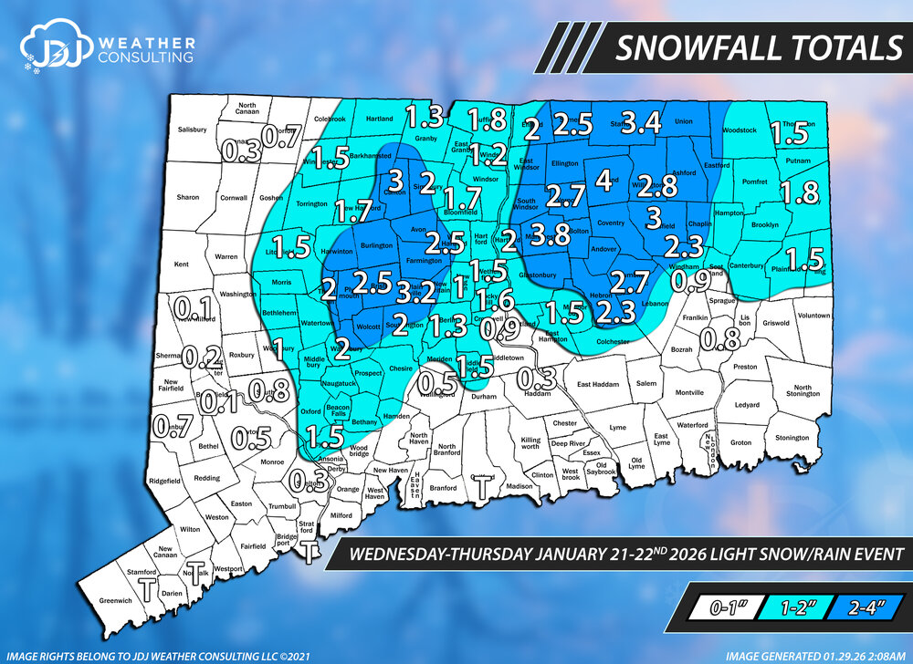
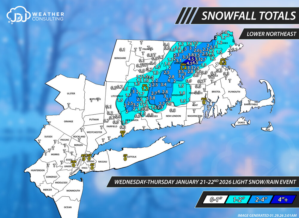
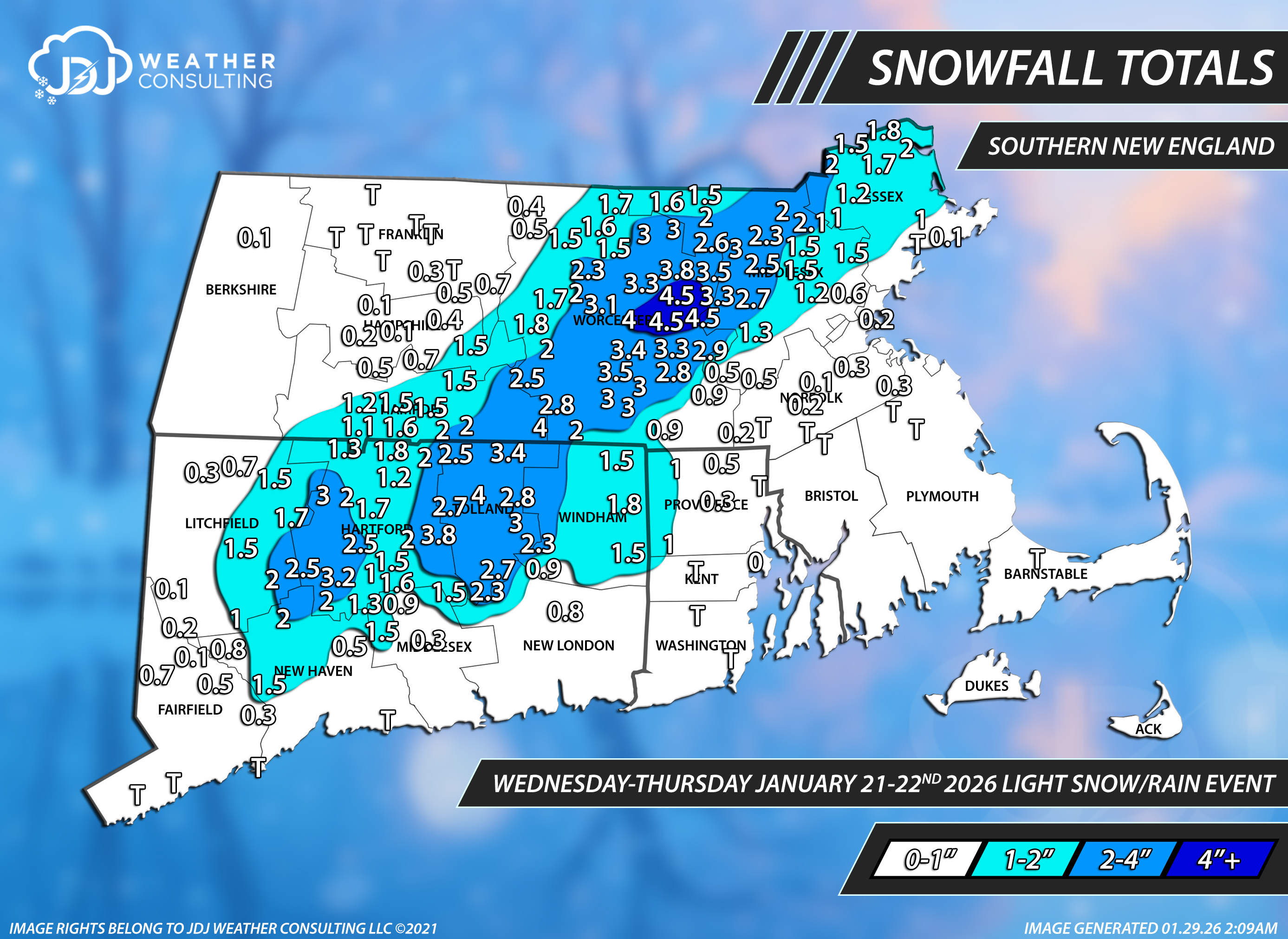
This event is now up as the 7th 3"+ snowfall event of the season with snowfall maps, radar and sfc/upper air maps. https://www.jdjweatherconsulting.com/jan-21-22-2026 Snowfall Totals