All Activity
- Past hour
-
48F. Gorgeous. Can't wait until this low temp is routine and not a just 24-hour aberration between 70F DP lows. I imagine that should occur sometime in January.
-
.thumb.gif.f92b16c631a1d15d405ed77b33f0710d.gif)
Septorcher 2026 Discussion - Endless Summer
Torch Tiger replied to Damage In Tolland's topic in New England
Gfs AI is not far offshore.thumb.png.86c0ccf237d9a021253853c8837a8cb2.png)
-
 canadian pharmacy: online pharmacy canada :: best online canadian pharmacy
 -
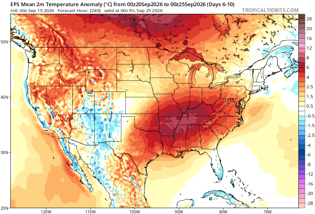
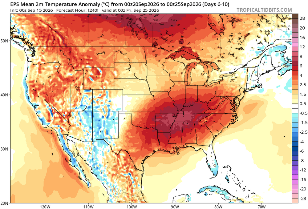
Just taking that [temperature] map from face value, I would take that as just a massive flood of PAC air into North America but the structure of those temperature anomalies I think can be the product of two scenarios: 1. A configuration in which Arctic air is displaced well south (akin to a +PNA/-AO combo) 2. Those colder anomalies in the south are the product of extensive clouds and precipitation, so the anomalies are more of a product of diurnal departures versus the result of a pattern favoring colder air displaced south. If that product is showing extreme cold departures on the other side of the hemisphere, then I would absolutely believe scenario 2. Now, obviously, at our latitude even slightly above temperatures can be fine for snow. So I'm not stating we'll be snowless...but it just adds another difficulty we'd have to contend with. But...the structure of the precipitation anomalies, sort of indicates to me increased potential for cyclogenesis off the SE coast...I'd take chances with bringing storms up the coast and just hoping we can get a far enough offshore storm track and pull in some cold. As you know, a "furnace" in southeast Canada does not mean lack of "cold"
-

2026-2027 Record-breaking El Nino
40/70 Benchmark replied to Stormchaserchuck1's topic in Weather Forecasting and Discussion
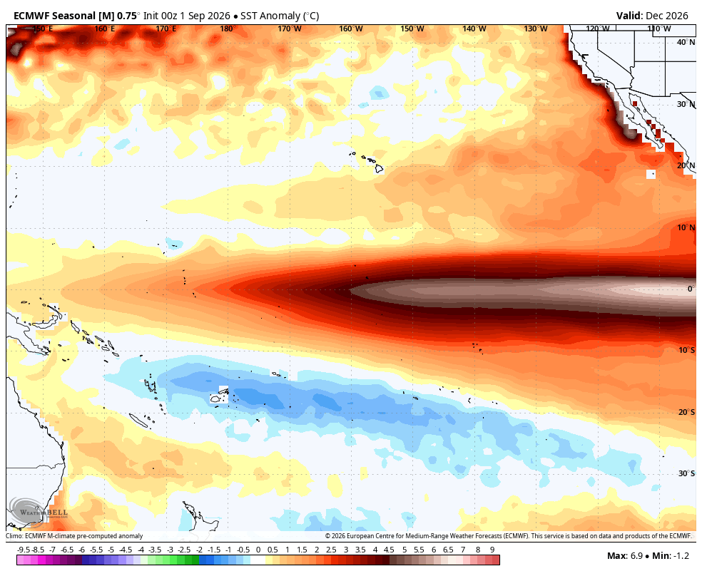
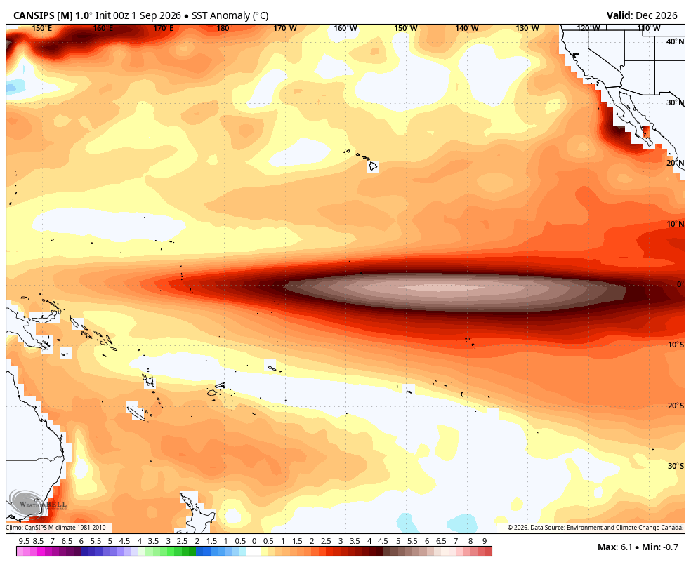
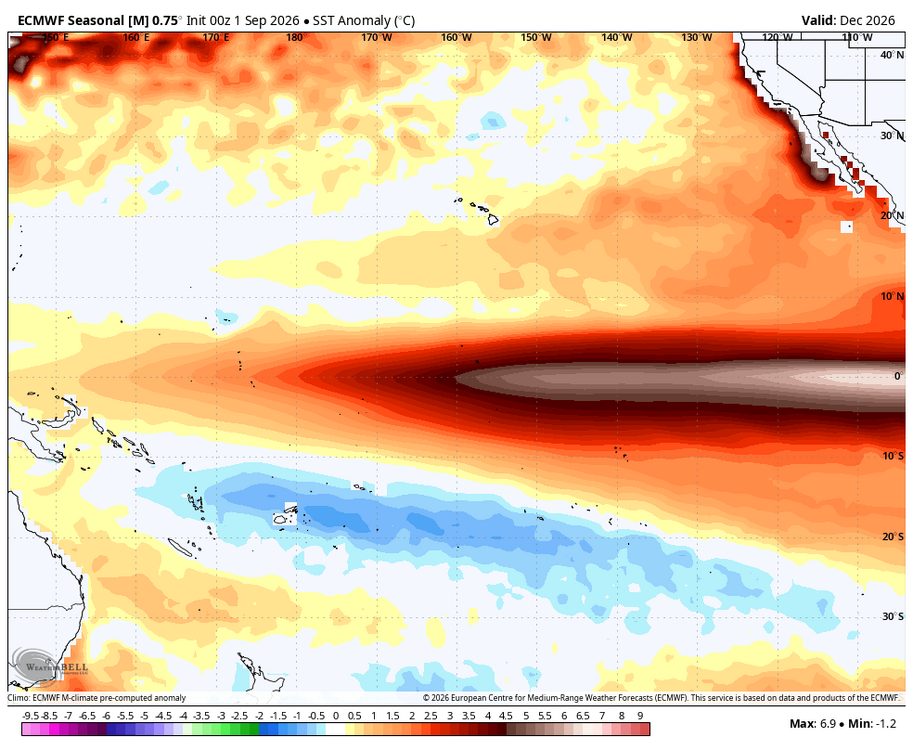
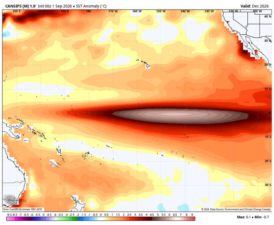
The December output def. seems further off than the DJF mean, though, Nick. -
is mexican pharmacy store legit: mexican pharmacy online reviews or prescriptions from mexico
-
Septorcher 2026 Discussion - Endless Summer
Torch Tiger replied to Damage In Tolland's topic in New England
AI has a few long-range Steinbusters as well -
http://indiagenericstore.com/# online medicine websites
-

Occasional Thoughts on Climate Change
TheClimateChanger replied to donsutherland1's topic in Climate Change
The numbers have been quality controlled. The raw observations do show 103°F but are now shown as missing as they failed the quality control test. Either way, it's a bogus reading that would require 110°F+ on the coastal Plain to be plausible. Mount Pocono was certainly not one of the warmest locations in the State of Pennsylvania, it's invariably one of the coldest due to its elevation. -
2026-2027 Record-breaking El Nino
40/70 Benchmark replied to Stormchaserchuck1's topic in Weather Forecasting and Discussion
If you read on, I noted that. It's come into much better agreement, though. -
49.6 early this morning
-

2026-2027 Record-breaking El Nino
OSUmetstud replied to Stormchaserchuck1's topic in Weather Forecasting and Discussion
-

Central PA Summer 2026 Discussion/Obs Thread
Superstorm replied to Voyager's topic in Upstate New York/Pennsylvania
46.6F at the Lancaster homestead this morning. -
2026-2027 Record-breaking El Nino
OSUmetstud replied to Stormchaserchuck1's topic in Weather Forecasting and Discussion
It's about 35°W with the warmest anomalies. 110°W on the Euro v. 145°W on the CANSIPS. Not trivial. -
Sandistril was the culprit on 2 of them I believe. He was pretty bad last year after good rookie season.
-

Septorcher 2026 Discussion - Endless Summer
dendrite replied to Damage In Tolland's topic in New England
Something tells me he put his weenie balls deep into that d12 00z euro solution -
Good point, I hadn't noticed that...it's actually like +4F.
-
Low of 64.9 and with the lower humidity it finally feels somewhat fall like
-

Septorcher 2026 Discussion - Endless Summer
kdxken replied to Damage In Tolland's topic in New England
Did you stumble upon a model? That's actually correct. -
I don't have an issue with the possibility of an awful winter, sure, but he used the word "never"....sorry, but that is an impossibility around here. Terd season, okay...but snowless? Nope-
-
September 15 1939: Minneapolis experiences a daily record high of 98. 1916: St. Paul receives their earliest recorded snowfall. For Tuesday, September 15, 2026 1752 - A great hurricane produced a tide along the South Carolina coast which nearly inundated downtown Charleston. However, just before the tide reached the city, a shift in the wind caused the water level to drop five feet in ten minutes. (David Ludlum) 1910 - Rains of .27 inch on the 14th and .73 inch on the 15th were the earliest and heaviest of record for Fresno CA, which, along with much of California, experiences a ""rainy season"" in the winter. (The Weather Channel) 1939 - The temperature at Detroit MI soared to 100 degrees to establish a record for September. (The Weather Channel) 1982 - A snowstorm over Wyoming produced 16.9 inches at Lander to esablish a 24 hour record for September for that location. (13th-15th) (The Weather Channel) 1987 - The first snow of the season was observed at the Winter Park ski resort in Colorado early in the day. Eight inches of snow was reported at the Summit of Mount Evans, along with wind gusts to 61 mph. Early morning thunderstorms in Texas produced up to six inches of rain in Real County. Two occupants of a car drowned, and the other six occupants were injured as it was swept into Camp Wood Creek, near the town of Leakey. Late afternoon and evening thunderstorms produced severe weather in central and northeastern Oklahoma. Wind gusts to 70 mph and golf ball size hail were reported around Oklahoma City OK. (National Weather Summary) (Storm Data) 1988 - Thunderstorms brought much needed rains to parts of the central U.S. Rainfall totals of 2.87 inches at Sioux City IA and 4.59 inches at Kansas City MO were records for the date. Up to eight inches of rain deluged the Kansas City area, nearly as much rain as was received the previous eight months. Hurricane Gilbert, meanwhile, slowly churned toward the U.S./Mexican border. (The National Weather Summary) 1989 - Showers and thunderstorms produced locally heavy rain in the Central Appalachians. Virgie VA received 2.60 inches of rain during the evening hours, and Bartlett TN was deluged with 2.75 inches in just ninety minutes. Heavy rain left five cars partially submerged in high water in a parking lot at Bulls Gap TN. Thunderstorms over central North Carolina drenched the Fayetteville area with four to eight inches of rain between 8 PM and midnight. Flash flooding, and a couple of dam breaks, claimed the lives of two persons, and caused ten million dollars damage. Hugo, churning over the waters of the Carribean, strengthened to the category of a very dangerous hurricane, packing winds of 150 mph. (Storm Data) (The National Weather Summary) Observances: 15 Tue Get Ready Day 15 Tue National Online Learning Day 15 Tue National Linguine Day 15 Tue National IT Professionals Day 15 Tue World Lymphoma Awareness Day 15 Tue National Double Cheeseburger Day 15 Tue International Day of Democracy 15 Tue International Dot Day 15 Tue National Hispanic Heritage Month 15 Tue Start of Hispanic Heritage Month (Until October 15) 15 Tue Butterscotch Cinnamon Pie Day 15 Tue Dot Day 15 Tue Felt Hat Day 15 Tue Make a Hat Day 15 Tue National Cheese Toast Day 15 Tue National Creme de Menthe Day 15 Tue National Custom Framing Day 15 Tue National D.A.R.E. Day 15 Tue National Google.com Day 15 Tue National Tackle Kids Cancer Day 15 Tue World Afro Day 15 Tue World Engineers Day 15 Tue Greenpeace Day
-

2026-2027 Record-breaking El Nino
mitchnick replied to Stormchaserchuck1's topic in Weather Forecasting and Discussion
We're going to need the Icon to settle this. Lemme' take a close look with my good eye. -
3 sacks was nice tho.
-

2026-2027 Record-breaking El Nino
GaWx replied to Stormchaserchuck1's topic in Weather Forecasting and Discussion
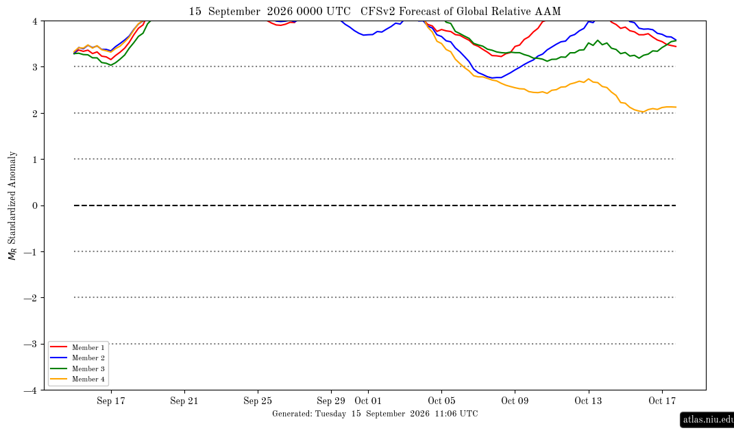
Latest (0Z of Sep 15th) CFSv2 AAM forecast, which is already at a very high >+3, is like yesterday progging an off the charts extreme/historic? +4+ starting by Sep 19th (earliest in the forecast I’ve ever seen) and lasting at least through Sep 24th: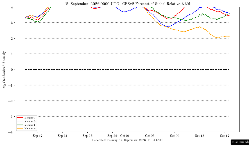
-
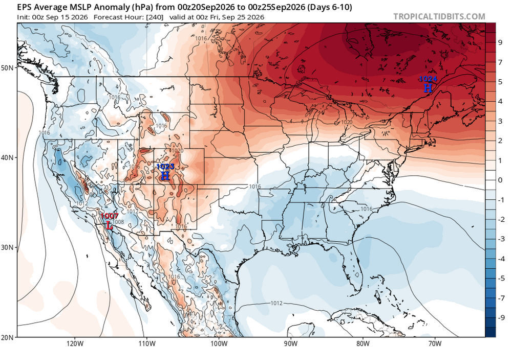
Plenty of easterly flow reducing the maxes is the main reason. It will be interesting to see if we can get a tropical connection established. Since lows often develop underneath the big highs east of New England this time of year.

.png.aedea8dc3a947a213cf748b7a6a5d98f.png)