All Activity
- Past hour
-
It was down to 32 all of the way down to parts of N FL including Cross City, Crestview, and Pensacola! KSAV was 34. Look out tonight for areas that radiate decently to have even colder lows.
-
RIP. Always enjoyed his posts.
-
 That place is so weird lol. That steady roar of the wind ripping through the trees last night was wild. It's been since Sandy since I've heard a steady roar like that. I haven't been out yet but I need hear chainsaws in the distance. That made the event for me. I love the little things. Give me a lion roar front and I'm happy. I'm a simple man.
 -
hoping some of the east breaks off and heads east.
-
 Canaan reportimg 8" new snow this morning and still coming down.
 -
off to san diego tomorrow. will report on the heatwave for all my amwx'ers
-
Yeah overall it truly was a bust yesterday and even on air meteorologists are basically saying the same. They are taking a beating today.
-
Also a lot of moisture still flowing in from TN along the border so there still should be some accumulation today in places.
-
Yeah no kidding. Both it and the Euro have had some big misses this season but the gfs has hanged tough for the most part.
-
 Seeing some pic of social media of damage near Camden & Federica that looks very tornado like. I'm thinking at least one of those warnings may verify. 33 this morning! lol, March gonna March
 -
My bad. I misinterpreted the high wind report categories. Now I realize that there were none of 65 knots+ and there also were no large hail reports.
-
Any tornadoes reported in NJ? Everyone who has a tree down or part of a fence is claiming there was one. The FB groups are going wild.
-
Also this is impressively cold for this time of the year. At my place according to the almanac I hit a record low of 15 degrees and today's highs will be some 25 to 35 degrees below normal. Highs will range probably from the 20s to the 30s and teens again tonight.
-
It’s impressive how bad the gfs performed coming into winter, then it woke up from coma swinging with brass knuckles.
-
def lighting bug also purple stroke density or bust
-
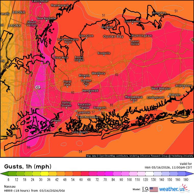
Yeah, the HRRR did a great job with this event.

-
Those were not 65+ knots. Those would be marked in black.
-

2025-2026 Fall/Winter Mountain Thread
Buckethead replied to Buckethead's topic in Southeastern States
I'm at 75" as of 7am Sent from my Pixel 10 Pro using Tapatalk -

2025-2026 Fall/Winter Mountain Thread
Upstate Tiger replied to Buckethead's topic in Southeastern States
Impressive! -
Also the GFS did the best job on this again. The Euro wasn't even close.
-
potholes about to go crazy
-
 2.5 of rain yesterday. Snowed last night, icy this morning.
 -
Correction on my snow totals. I forgot about the last big snow. Currently im sitting at 30.5 inches for the year.
-
Records: Highs: EWR: 78 (1990) NYC: 75 (1945) LGA: 74 (1945) JFK: 69 (2003) Lows: EWR: 16 (1981) NYC: 9 (1916) LGA: 15 (1967) JFK: 13 (1967) Historical: 1841: March 16-18, A heavy snowstorm dropped up to 30 inches of snow in the Tidewater area, measured in areas unaffected by wind. (Ref. Virginia Weather History) 1892 - A winter storm in southwestern and central Tennessee produced 26 inches of snow at Riddleton, and 18.5 inches at Memphis. It was the deepest snow of record for those areas. (David Ludlum) 1906 - The temperature at Snake River, WY, dipped to 50 degrees below zero, a record for the U.S. for the month of March. (Sandra and TI Richard Sanders - 1987) 1952: The ban on using the word "tornado" issued in 1886 ended on this date. In the 1880s, John P. Finley of the U.S. Army Signal Corps, then handling weather forecasting for the U.S., developed generalized forecasts on days tornadoes were most likely. But in 1886, the Army ended Finley's program and banned the word "tornado" from forecasts because the harm done by a tornado prediction would eventually be greater than that which results from the tornado itself. The thinking was that people would be trampled in the panic if they heard a tornado was possible. The ban stayed in place after the Weather Bureau; now, the National Weather Service took over forecasting from the Army. A tornado that wrecked 52 large aircraft at Tinker Air Force Base, OK, on 3/20/1948, spurred Air Force meteorologists to begin working on ways to forecast tornadoes. The Weather Bureau also began looking for ways to improve tornado forecasting and established the Severe Local Storm Warning Center, which is now the Storm Prediction Center in Norman, OK. The ban on the word "tornado" fell on this date when the new center issued its first Tornado Watch. 1970: Chicago, IL had their greatest snowstorm for so late in season as 14 inches fell. (Ref. Wilson Wx. History) 1985: A strong F3 tornado tore through Venice, FL during the early morning hours. 55 homes were destroyed and 220 were damaged. Two people were killed and 45 were injured. (Ref. Wilson Wx. History) 1987 - A powerful spring storm produced severe thunderstorms over the Central Gulf Coast States, and heavy snow in the High Plains Region. A tornado caused three million dollars damage at Natchez MS, and six inches of rain in five hours caused five million dollars damage at Vicksburg MS. Cactus TX received 10 inches of snow. Western Kansas reported blizzard conditions. (The National Weather Summary) (Storm Data) 1988 - A winter storm produced heavy snow from the northeast Texas panhandle to the Ozark area of Missouri and Arkansas. Up to fifteen inches of snow was reported in Oklahoma and Texas. Snowfall totals in the Ozark area ranged up to 14 inches, with unofficial reports as high as 22 inches around Harrison AR. (The National Weather Summary) (Storm Data) 1989 - Strong northerly winds ushered snow and arctic cold into the north central U.S. Winds gusted to 58 mph at Sydney NE and Scottsbluff NE, Cadillac MI received 12 inches of snow, and International Falls MN reported a record low of 22 degrees below zero. (The National Weather Summary) (Storm Data) 1990 - Showers and thunderstorms associated with a slow moving cold front produced torrential rains across parts of the southeastern U.S. over a two day period. Flooding claimed the lives of at least 22 persons, including thirteen in Alabama. Up to 16 inches of rain deluged southern Alabama, with 10.63 inches reported at Mobile AL in 24 hours. The town of Elba AL was flooded with 6 to 12 feet of water causing more than 25 million dollars damage, and total flood damage across Alabama exceeded 100 million dollars. Twenty-six counties in the state were declared disaster areas. (The National Weather Summary) (Storm Data) 2002: A Pacific storm system with lots of moisture caught forecasters by surprise, dumping 25.7 inches of snow at Anchorage, AK in 24 hours, easily surpassing the old record of 15.6 inches. (Ref. Wilson Wx. History) The record was not merely broken, it was smashed. Anchorage AK Int’l Airport received 28.7 inches. Snow in a 24-hour period almost doubling its old record of 15.6 inches. The SE side of Anchorage was “downsloped” so much less snow fell; Rabbit Creek had 6 inches. (Ref. Weather Guide Calendar with Phenomenal Weather Events 2012 Accord Pub. 2011, USA)
-
Are you saying that the front itself produced that many 65+ knot reports? If so, wow!