All Activity
- Past hour
-
Been a LONG time since the Boston Metro has gotten a blocked low, conveyer belt QPF bomb. Much different storm at the synoptic scale, but that radar across EMass looks like March 2013. Huge returns pivoting in off the Bay, RI and South Coast slotting
-
And more boomers..judging by the radar, that line is blossoming just offshore, maybe we can get it to pivot back west for a little more action
-

Central PA Spring 2025
Itstrainingtime replied to canderson's topic in Upstate New York/Pennsylvania
My wife gets cold too...and she knows exactly where to find her sweatshirts. -
Probably the second half of June…
-
Not even close to 90 yet here. Not even that many 80s and the next couple weeks looks cool and wet. May is already around average rainfall and 2-3 inches seems likely through the end of the month.
-
Out on the town and it seems like the customers from the shirt sales back in the day are still pleased.
-
So I haven’t heard a single rumble of thunder all day. wtf
-
We get our jackpots when we don’t usually want em but I’m glad to see the piles of pollen being washed away with brute force this time around. This storm has been more than impressive so far and it’s still coming down steadily. We must be over 4” by now too.
- Today
-
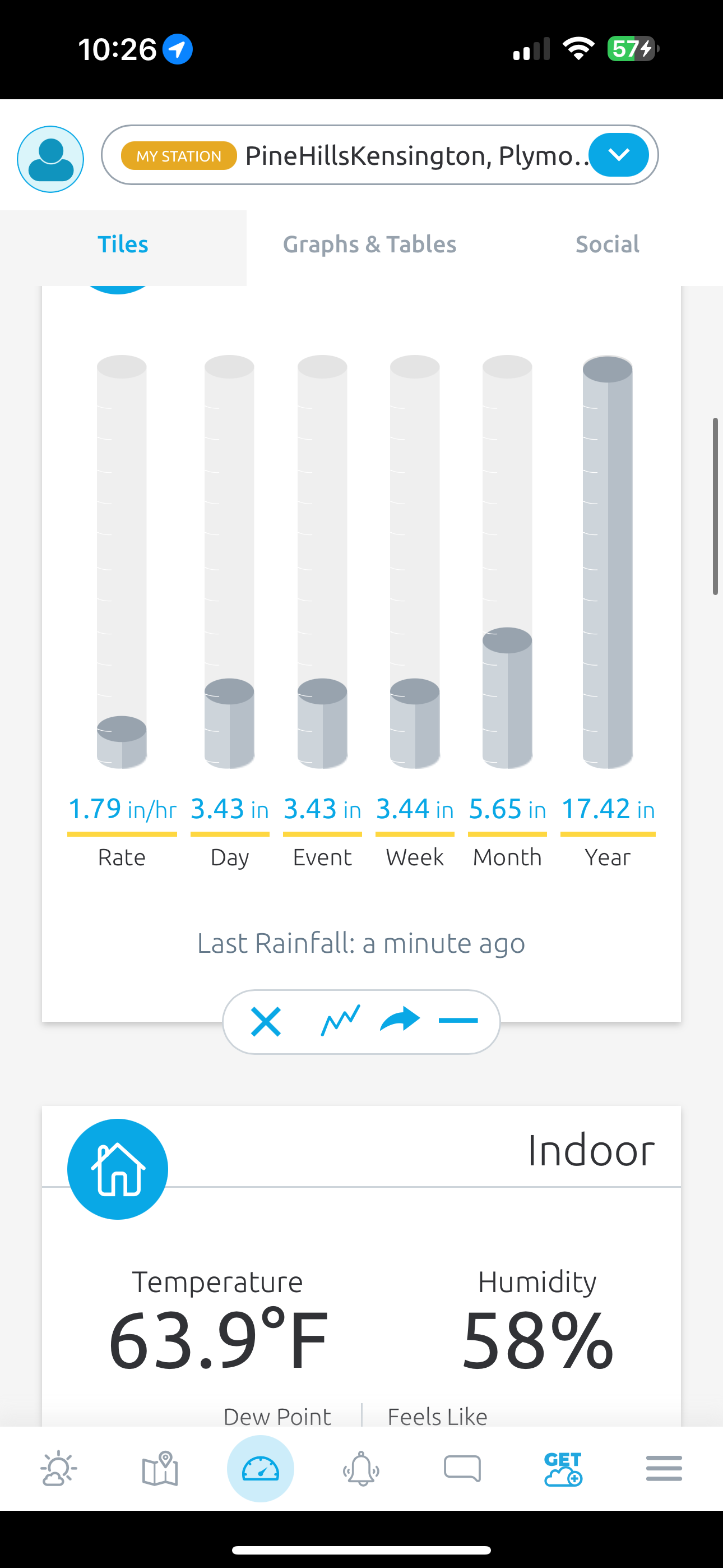
0.78" Yesterday (5/21) 0.39" Today (5/22) Event Total: 1.17" Not bad. I'll take that and run. Everything is really green right now within the neighborhood. Walked in the light rain this afternoon. Couldn't complain Currently 56/54
-
No stein there. Climo evens out. Your bread and butter (ha) type heavy precip event for you guys… a coastal low crushing.
-
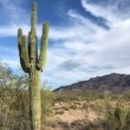
It’s my first time out here, and I’m impressed by this desert sun lol. Really wish I could’ve gotten out to Death Valley but just didn’t have enough time.
-
Pretty impressive stuff. And better now than Saturday-Monday.
-
Some decent ltg earlier. Looks like 5-6” amounts rt 3 from near Norwell to PYM. just about 4” here
-
METARS you don’t expect to see in late May. KBOS 230154Z 03024G38KT 1 3/4SM +TSRA BR SCT008 BKN011 OVC017CB 08/07 A2973 RMK AO2 PK WND 04038/0151
-
Not too often to see a 24 hours like this. Miserable weather.
-
Yet we can't have this in January with a cold high over W Quebec? It's been .25" of rain per hour since 6pm
-
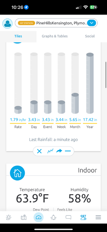
Almost 3.5 inches at my location in Eastern Plymouth, Ma, crazy couple of hours including thunder and lightning. .
-
Impressive for late May...
-
Hey if we get a few more events like this over the next couple weeks, us dew crewers might see it happen soon! If only it would come without all the damn ants that love to descend on every sugar granule and crumb left behind.
-
Low of 61, high of 85. Dew points in the low 50's made for a pretty decent day.
-

E PA/NJ/DE Spring 2025 Obs/Discussion
LVLion77 replied to PhiEaglesfan712's topic in Philadelphia Region
49.9F and about an inch of rain for the event (regional precip total map a lot more uniform for this event than just about any other event this spring!)A lot less rain over the next 7 days but still lots of clouds unfortunately. We need a week of dry sunny warmth. . -
I was it was 100 here…but over a 75 dewpoint
-
Just heavy precipitation rotating up through the eastern NE (esp SNE) zones. SE and E Mass look to be getting smoked. Impressive radar loop.
-
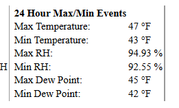
Abundance of sun here as well, managed a late afternoon high of 102 today off a low of ~72. Our warmest of the year thus far. Currently sitting at 100/21, dewpoints have been in the upper teens and low 20s all day. Looks downright miserable back in the coastal plain of NNE, I certainly don't miss these late May/June debacles.
-
Thunder in Fenway area


.thumb.png.4150b06c63a21f61052e47a612bf1818.png)