All Activity
- Past hour
-
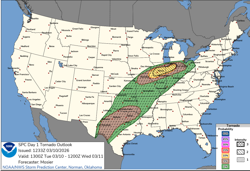
So we are getting cute and hashing 90% of the area as increased tornado threat and the other 10% is supposed to be enhanced due to other reasons? Doesn’t really make sense.
-
Someone should start a thread for late Thursday into Friday. Euro and GFS hinting at a period of snow for some of the region.
-
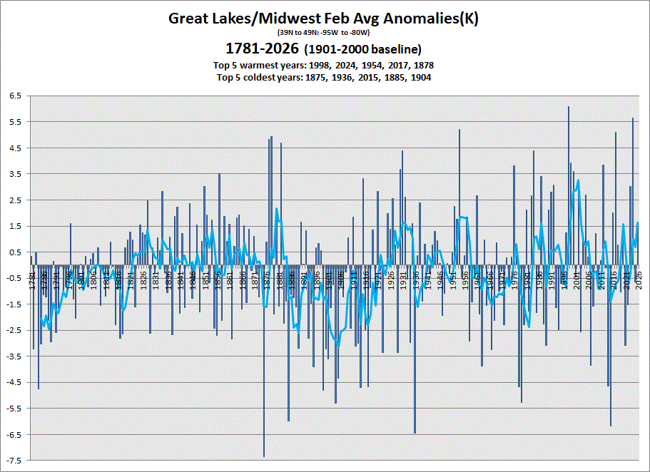
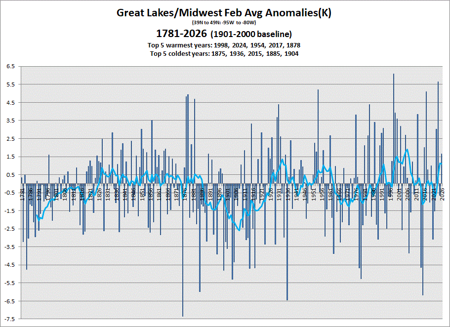
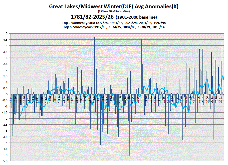
Early data in for Feb. Warmer Feb with an avg Winter in the books. 5 & 10 yr trend charts shown respectively.

-
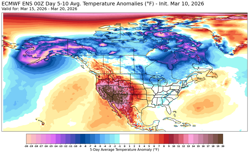
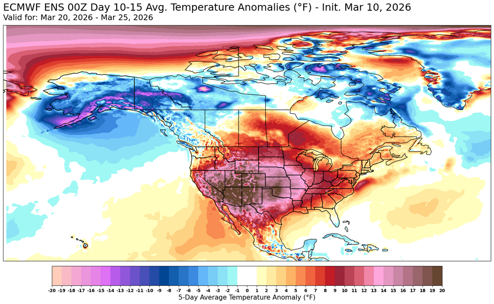
There’s so much cold not far away in Canada. Right thru end of Morch that PV just sits up there and models show cold up there. I don’t think we are done yet. Suggest we enjoy today
-
I am still trying to gauge this new conditional intensity thing. But I am with you...seems odd the entire thing isn't filled in and what additional value does this have over the regular hatching? But I guess its to highlight what the "max intensity" may be. IDK...I feel like this is going to cause more uncertainty or even hype that isn't needed
-
lol, so ugly but also, let's go
-
Enjoy today, rest of the month looks fairly miserable.
-
I haven’t followed these new SPC products.
-
Why would they not hash that whole Enhanced area?
-
Snowmelt will become more accelerated Wednesday night as dewpoints climb into the 50s and most of the snowpack outside of the Berkshires will likely be depleted by Thursday
-
He can’t handle it
-
It will be interesting to see if this pattern continues into the summer with pieces of the Western heat coming east from time to time.
-
Masts raised?
-
When was the last snowy March, regionally? Seems like ages
-
Records: Highs: EWR: 81 (2016) NYC: 79 (2016) LGA: 78 (2016) JFK: 71 (2006) Lows: EWR: 10 (1984) NYC: 12 (1929) LGA: 12 (1984) JFK: 12 (1984) Historical: 1884: John Park Finley issued the first experimental tornado prediction. Finley studied the atmospheric parameters that were present during previous tornadoes. Many of these same criteria are still used by operational forecasters today. But the use of tornado forecasts would be banned just a few years later and remain forbidden until 1952. 1912 - The barometric pressure reached 29.26 inches at Los Angeles, CA, and 29.46 inches at San Diego CA, setting all-time records for those two locations. (David Ludlum) 1922 - Dodge City, KS, reported a record 24 hour total of 17.5 inches of snow. (The Weather Channel) 1960: Snowstorm in southeast U.S. gave GA 10.0 inches of snow and TN had 22.0 inches, VA 15.0 inches and KY had 24 inches. Four to 15 inches fell across Virginia with drifts much higher. North Carolina recorded drifts from 3 to 30 feet! Many buildings collapsed from the accumulative weight of the snow and structural damage totaled into the millions. (Ref. Virginia Weather History) 1964: The maximum temperature for the date is 77 °F in Washington, DC. (Ref. Washington Weather Records - KDCA) 1972: Chicago, IL's temperature rose from 15° on this date to 73° on the 11th. The 58 degree rise ties the biggest day-to-day rise on record. The city experienced a similar jump in temperature in February 1887. (Ref. Wilson Wx. History) 1986: Severe thunderstorms and tornadoes hit Indiana, Kentucky, and Ohio. A total of 19 tornadoes occurred. Three of the tornadoes in Indiana reached F3 intensity. A densely populated subdivision of Southeast Lexington, Kentucky, was heavily damaged by a tornado. Twenty people were injured, and 900 homes were destroyed or demolished. A very strong thunderstorm downburst hit the Cincinnati area. At the Greater Cincinnati Airport, windows were blown out of the control tower, injuring the six controllers on duty. At Newport, Kentucky, 120 houses were destroyed by winds estimated from 100 to 140 mph. 1987 - Strong northwesterly winds ushered arctic air into the eastern U.S. Gales lashed the middle and northern Atlantic coast. Winds gusted to 50 mph at Manteo NC and Cape Hatteras NC. (The National Weather Summary) (Storm Data) 1988 - A winter storm produced snow and high winds in the Central Rocky Mountain Region. Snowfall totals in Utah ranged up to 42 inches at Alta, with 36 inches reported at the Brian Head Ski Resort in 24 hours. Winds gusted to 72 mph at La Junta CO and Artesia NM. (The National Weather Summary) (Storm Data) 1989 - Thirty-four cities in the central and southwestern U.S. reported new record high temperatures for the date. The high of 85 degrees at Hanksville UT was a record for March, and Pueblo CO equalled their March record of 86 degrees. Hill City KS warmed from a morning low of 30 degrees to an afternoon high of 89 degrees. (The National Weather Summary) 1990 - Thunderstorms developing along a warm front produced severe weather from southeast Iowa to central Indiana and north central Kentucky. Thunderstorms produced wind gusts to 65 mph at Fort Knox KY, and hail two inches in diameter west of Lebanon IN. Evening thunderstorms over central Oklahoma deluged Guthrie with 4.5 inches of rain. (The National Weather Summary) (Storm Data) 1996: Record high barometer reading of 30.91 inches today the highest pressure at Annandale Weather Center since February 26, 1990 when the barometric pressure read 30.94 inches. (Ref. Annandale Weather Records) 2003: 90% of the surface of the Great Lakes was covered by ice, the most since February 1994, as a cold winter continued to grip the region. (Ref. Wilson Wx. History) 2006: A powerful winter storm hit southern California through the 11th. A waterspout came ashore in Encinitas causing trees to fall over a railroad track halting traffic. Hail was widespread throughout San Diego County and even accumulated in places with one inch diameter hail reported in Escondido. Snow fell as low as 1500 feet in elevation. 36 inches fell at Big Bear Lake and Lake Arrowhead. (Ref. Wilson Wx. History) 2010 - As many as four people are injured, one is killed and homes were damaged in Center Hill and Pearson, AR, by an EF2 tornado.
-
B+ A very good winter indeed, based on 66 years of observation. In relative terms it was an "A".
-
First go around with an intensity 2 for tornadoes (also have it for hail in Texas). Very curious to see how this changes or enhances public communication or if it just adds confusion. I wonder what @OceanStWx thoughts on this conditional intensity addition is.
-
Still looks like a remarkably well handled back door front arrives to kill the fun like 9 pm flickering blue lights for tomorrow. It's true though that Thursday should really remove the remainder of flat expanse coverage down to mud and field if today doesn't. It'll be windy warm DP air with 60s out ahead of that front. It's the difference between dropping ice in the sink, versus then turning on the warm water.
-
49 / 48 clear. On the way to mid / upper 70s and stray 80 possible (last Oct 7 / 5th) in NJ. Front and clouds arrive tomorrow but it still may be warm enough ahead of the cooler air to hit 70 (for some that make 4 straight days). Showers and light rain with the front rainfall near 0.10 for most Wed evening into Thu morning. Clouds stick around Thu / part of Fri - cooler near - below normal between the 3/12 - 3/15th then below / much below avg Tue / Wed next week as trough moves into the EC. Moderation towards normal overall between 3/20 end the close back and forth.
-
It's a bit early for my liking as well. Permanent DST would feature some incredibly dark winter mornings especially when it's cloudy
-
Nahhh... everyone lost 1/3 to 1/2 of their snow under 68 F and beating sun, yesterday. Just because you can't yet see bare ground, doesn't mean warmth was defeated. Man, the filtration that goes on in here looks like reality rendering at times
-
Yep it's a mess out there-alot of work for landscapers and public works-not to mention all the potholes from the freeze/melt cycle of the snowfalls
-
We broke 70 here yesterday…truck was 72 and 73. Can we go 75 plus today?
-
It’s Tue morning. If you rewarm sector tomorrow night it will be ravaged by dews.
-
I loved that storm. I just moved into my apartment in West Roxbury the day before. Woke up to this epic storm. I think we ended up with 30". It was my first day taking the train to Boston from West Rox. I was surprised that the train was on time...until I was told that the train I boarded was 2 hours late from earlier.


.thumb.png.4150b06c63a21f61052e47a612bf1818.png)


