All Activity
- Past hour
-

2025 Atlantic Hurricane Season
BarryStantonGBP replied to BarryStantonGBP's topic in Tropical Headquarters
-
0.07” with that shower at CON…0.27” MTD now. Nothing here yet. 67.6° BKN
-
Pop up showers on the Cape too.
-

2025-2026 ENSO
40/70 Benchmark replied to 40/70 Benchmark's topic in Weather Forecasting and Discussion
Yea, lock that. Been obvious for awhile. I snowman will point out how it doesn't matter when its weak, but it does when you have an easterly QBO near solar max reenforcing a weak/east-based cool ENSO regime. -
Another paper that might become relevant this coming year: https://www.nature.com/articles/ngeo760
-
Based on the last few times it'll either be upper 90s in the first week, a week of mid/upper 80s in the 2nd or 3rd week, or an 80+ around Halloween.
-
2025-2026 ENSO
40/70 Benchmark replied to 40/70 Benchmark's topic in Weather Forecasting and Discussion
Matches my polar composite well. -
2025-2026 ENSO
40/70 Benchmark replied to 40/70 Benchmark's topic in Weather Forecasting and Discussion
https://easternmassweather.blogspot.com/2025/08/preview-of-extra-tropical-pacific-for.html
-
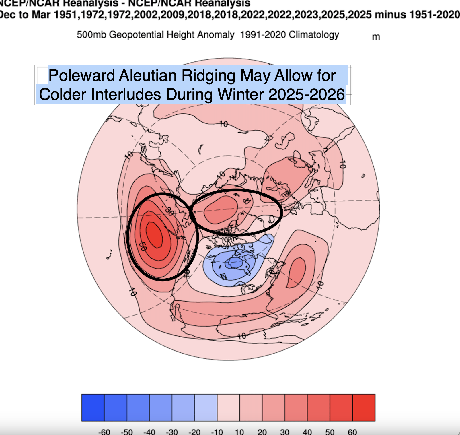
Preview of the Extra Tropical Pacific for Winter 2025-2026 Above Average Confidence Relative to Extended Lead Time Brief ENSO Update The August update from the International Research Institute (IRI) offered very little change with respect to the expectations for ENSO moving ahead into winter 2025-2026. Although the La Niña criteria as per the Climate Prediction Center of 5 consecutive ONI periods of -0.5 or lower is highly unlikely to be met, there is still likely to be at least a meager cool ENSO influence around the hemisphere during the coming winter. This is due to a combination of factors, which includes the likelihood that IRI guidance is likely to correct a bit cooler in conjunction with a Multivariate ENSO Index (MEI) and Relative Ocean Nino index (RONI) that will be reflective of a solidly weak La Niña event that will perhaps even approach moderate at peak. A more elaborate discussion of the ENSO forecast was posted in July and should be referenced for a more elaborate explanation of the aforementioned expectations moving forward. Indeed, although a more meager ENSO influence implies a reduced impact on the extra tropical Pacific per se, there is still a degree of utility in comparing preferred ENSO composites with those derived from the analysis of other key drivers. Weak, East-Based La Niña Impact on Extra Tropical Pacific The expectation for both a weaker and east-based La Niña influence during winter 2025-2026 remains consistent with earlier analysis this summer. Note that the behavior of the subsurface during the month of August was anticipated quite well last month, and continues to set the stage for an eastern biased event centered around 120 degrees longitude. Historically speaking, in east-based La Niña winter seasons there is both a high latitude blocking signature and a prevalent poleward Aleutian ridge displaced to the northwest, off of the west coast of the CONUS relative to the central-based and Modoki La Niña composites. These are shared features with the weak La Nina composite, which is similar due to the fact that the majority of east-based events are also weaker cool ENSO episodes . Thus it is not surprising that the composite of the three primary El Niño Modoki Index analogs of 1995, 2017 and 2021 were all centered in the vicinity of 120 West longitude, and 2/3 were weak events; with the 2021-2022 La Nina representing the lone moderate season. Nor is it a shock that the pronounced Aleutian ridging positioned off of the coast and protruding poleward in conjunction with some degree of NAO blocking is also very evident. If La Niña were stronger, there would be higher confidence in this type of regime being prevalent throughout the majority of winter 2025-2026. However, the relatively paltry anticipated strength of this particular cool ENSO event leaves greater doubt as to the final outcome, thus it is paramount to be both eclectic and exhaustive in approach when diagnosing the extra tropical regions for the ensuing winter season. Given the fact that one of the most telling indicators is an overwhelmingly strong signal from any of the major teleconnections, the record monthly -PDO value just recorded is of particular interest. Record July Strength of Pacific Cold Phase is Telling The -4.00 value of the Pacific Decadal Oscillation (PDO) that was recently recorded for the month of July represents the lowest monthly value on record dating back to January 1854, which is very significant given that fact that were only 10 cool ENSO seasons during that 171 year sample that recorded a July PDO value of even -2 or lower, never mind -4. Every single one (10/10) of those subsequent seasons averaged a -PDO during the DM period, thus it is a very safe assumption that that will also be the case this season. The mean DM PDO value for this data set is -1.61, thus the expectation for winter 2025-2026 is that the DM PDO value will fall within a range of 1-46 to -1.76. The expectation for a negative PDO is consistent with La Niña seasons. The behavior of the extra tropical pacific is usually relatively predictable during a cool ENSO event such as the present one and vice versa. Intense negative PDO episodes are usually accompanied by La Nina because the two share a symbiotic, mutually reenforcing and sustaining relationship. La Nina represents the cold phase of ENSO and cooler waters present during episodes of La Nina such as the one observed this season tend to be generally supportive of a negative phase of the Pacific Decadal Oscillation (PDO), which are marked by cooler waters along the west coast of the US.This is because la Nina favors Aleutian ridging, as identified in the la Nina composite below: Although the developing La Niña is expected to remain weak, the current severely negative PDO resulting from the persistent western Pacific warm pool that has been prevalent for the past decade will ensure yet another -PDO winter seasonal in the mean. However, it is evident that the PDO value elevates throughout the winter from the very low summer level in the severely negative July PDO analogs, which implies that the seasonal PNA value may not be as low as surmised intuitively. This is denoted by a mean DM seasonal PNA value that is essentially neutral at -.23. It is with this in mind that the mean DM PNA value for winter 2025-2026 is expected to be a product of a great deal of intraseasonal variability and is forecasted to be biased ever so slightly negative within a range of -.08 to -.38. Given the anticipated variability with respect to the PNA during the coming winter season, the North Pacific pattern will take on an added measure of significance. Disparate North Pacific Regimes The first pattern is associated with a distinct negative phase of the East Pacific Oscillation (EPO) appeal in which high latitude ridging is concentrated in the general vicinity of Alaska and the Gulf of Alaska. This was the prevalent pattern last season. Here is the DM 500mb composite of these la Nina seasons: Note that the giant EPO style ridging delivers cold, as 31% of these seasons averaged a negative NAO for the DM period, which is important because this is the extra tropical pacific pattern favored in the analysis of the polar domain. In fact, this composite contains three polar analog seasons (2017-2018, 2021-2022 and 2024-2025), making it the preferred extra tropical Pacific pattern for the coming winter. Thus this further bolsters the argument for some degree of high latitude blocking during winter 2025-2026, which is consistent with the weak/east-based La Niña datasets. DM temp anomaly composite: Said EPO block also inhibits Pacific moisture inflow in the absence of a split flow, which limits precipitation across most of the nationDM Precip anomaly composite: The second extra tropical Pacific pattern to be discussed features a -PNA as the most prominent characteristic and contains the PDO analogs of 2022-2023,1971-1972, and 1955-1956. The 1955-1956 analog will be discarded due to the strength of La Niña. 40% of these seasons averaged a DM -NAO, which is the most of the 3 datasets, due to the fact that lower heights to the north, which is typical of la Nina, are displaced to the west and away from the Davis Strait and Greenland. DM H5: This pattern also allows for the delivery of cold, albeit spilling west first, before bleeding east-southeastward. DM Temp anomaly: This is a regime that allows for a great influx of Pacific moisture with a slightly less prominent EPO ridging a bit further off of the west coast. DM Precip anomaly: This solution offers the greatest blend of cold and snow for the eastern US on average due to blend of ample cold and available moisture. The final composite is the mildest of the three. The +EPO composite features a more defined Pacific jet and thus a milder overall appeal. Only 28% of winter seasons averaged a -NAO for the DM period, which coupled with lower heights in the vicinity of Alaska, spells a very mild winter for the east in the DM aggregate mean. This composite contains the PDO analogs of 1950-1951, 2001-2002 and 2011-2012. The 2011-2012 analog will be disregarded given its status as a moderate Modoki event. DM H5: DM Temp anomaly: DM Precip Anomaly: In Summary, the general implication of each of the data sets for the east coast winter season are as follows: 1) -EPO composite=cold and dry 2) -PNA composite=cold and wet (snowy) 3) Mild with moderate moisture influx biased north. Given the preference for a -EPO style extra tropical Pacific regime during winter 2025-2026 due to the heavy representation of this pattern in the polar analog composite, the mean JM EPO value of -.03 for this polar data set will be the basis for the +.12 to -.18 forecast range for winter 2025-2026. While this value is essentially a neutral calculation, the season is expected to act more -EPO like due to the abundance of poleward Aleutian ridging immediately to the west of the EPO domain. The final piece of the extra tropical Pacific puzzle is the westerN counterpart to the EPO, the West Pacific Oscillation (WPO). West Pacific Crucial to Impact of High Latitude Blocking A clear theme in the analysis concerning both the arctic and the extra tropical Pacific is that there should be at least some period(s) of high latitude blocking during the coming winter season, however, how said blocking manifests varies rather significantly depending on the state of the western Pacific. Here is one dual month -NAO composite. In this December 1995, 2009 composite, a significant -NAO combines with a bonafide -WPO to depress southern heights and allow cold air to pool throughout the east coast. This regime also enhances east coast cyclogenesis by lowering southern heights and thus relaxing the Geopotential medium. Here is a March 2018 and 2023 composite, which also features a strong negative NAO, however, the WPO is significantly positive. Note that the bulk of the cold is focused west and the east is relatively mild. The +WPO also elevates southern heights across the eastern US, which acts increase the compression in the flow and shear major east coast development. While this is not absolutely prohibitive to major eastern storms, it does relegate any major storminess to northern stream redevelopments that mainly impact the northeast and often have precipitation type issues due to marginal cold. How this information can be applied to winter 2025-2026 is a work in progress. Although the WPO in general has been relatively difficult to forecast on a seasonal level due to dearth of highly predictive methods, the previously referenced west Pacific warm pool has made it a comparatively easy endeavor of late. In fact, there have been only two bonafide -WPO seasons over the past decade since this feature became prevalent during the 2015-2016 season. Independent of this larger scale warm pool attributable proclivity towards +WPO, the only skillful correlation is in the vicinity of the eastern Indian Ocean between the months of August and November. Obviously it is too early to glean much at this juncture in August, but this area will monitored throughout the autumn in an effort to garner an increased measure of confident for the final winter outlook. In the mean time, here is a perfunctory an effort to assess whatever can be gleaned at this early juncture in the August to November timeframe. Versus the current scene as of August 25th. This crude analysis seems to imply a slightly positive WPO that would not necessarily be prohibitive to an episode or two of major east coast cyclogenesis and some protracted period(s) of cold. As summer draws to a close and the autumn season progresses, here is a comparison of opposite ends of the spectrum as it pertains to the August to November eastern Indian Ocean DM WPO indicator. In the meantime, the mean DM WPO value of the preliminary extratropical Pacific composite is +.17 and implies a forecast range for winter 2025-2026 of between +.02 to +.32. Conclusions While an official La Niña per CPC guidelines is unlikely to materialize, an exhaustive intensity assessment that incorporates anticipated trends in current intensity guidance, the MEI and RONI suggest that a solid weak La Niña event should be the baseline assumption for winter 2025-2026. Eastern Mass Weather is in agreement with the current consensus for a an east-based, or at least eastward leaning event. Although La Niña in and of itself will not be a prominent driver in the hemisphere this winter, a combination of considerable baseline forcing redolent of cool La Niña owed to the persistent west Pacific Warm Pool in conjunction with solar influences on the stratosphere will ensure that the polar domain will be modulated in a manner that is consistent with a meager eastern biased La Niña event. This will include spasmodic flexing of PNA ridges and especially frequent poleward Aleutian ridging teaming with occasional -NAO blocking to allow cold to infiltrate the east with more intensity and duration than the vast majority of the past decade. The primary mitigating factors being that the NAO should be biased positively more often than not, and most importantly, the WPO averaging at least somewhat positive will hinder the ability for cold and snow to reach the southern mid Atlantic/southeastern US, while limiting residence time said cold throughout the northeast. This will also reduce the opportunity for major east coast cyclogensis and render the primary modes of storm development as southwest flow events (SWFEs), northern stream Miller B redevelopments and overrunning events. While odds of a KU type of event are below climatological average, they are higher than many recent seasons during this west Pacific warm pool predominate regime.
-
 This is the best we can do. Beats the majority of Augusts recently where we are cranking out tons of 90s still.
 -
 It's the other way around, the cycles are progressing in a fashion that should be making us cooler. But they are being overwhelmed by greenhouse gas emissions.
 -
one year when I was younger I was 3-wheeling with best friend and nature called. Grabbed some leaves to wipe and had the most extraordinary experience trying to wait tables at work and function for a few days after.
-
Can confirm that despite it being 73° it’s still plenty hot in direct sun. Also—WTTTE on that coastal. We boring for the foreseeable.
-
-

Mid to long range discussion- 2025
WinstonSalemArlington replied to wncsnow's topic in Southeastern States
Fall staged a coup on Summer https://x.com/awxnov/status/1960686926773592376?s=46&t=5ny5bPgiX5Vy3bQMvYTY5g -
Zero. Zip. Nada.
-
Some of the earlier runs had the sfc flow backing a bit and a hint of a closing sfc reflection, but it never looked like much of a big deal for SNE. There may have been a run or two where it enhanced rainfall for N ME.
-
Has been absolutely beautiful weather for the first week of college in Charlottesville. Praying the eventual October heatwave isn’t that rough.
-
@Bluewave
-
 Only going to get worse as we head deeper into the interglacial period of this Milankovitch cycle
 -
Even though you're annoying with this stuff you're not wrong. I'm not impressed with a -2 that was barely a -1 only 5 years ago. I'll take it of course because it's better than nothing
-
Somewhere in central Queen Annes county might be a good spot for one.
-

2025 Atlantic Hurricane Season
olafminesaw replied to BarryStantonGBP's topic in Tropical Headquarters
Feels like the kind of year for some kind of wonky subtropical landfall -
2025 Atlantic Hurricane Season
BarryStantonGBP replied to BarryStantonGBP's topic in Tropical Headquarters
“Normal” ”below normal”
- Today
-

2025 Atlantic Hurricane Season
NorthHillsWx replied to BarryStantonGBP's topic in Tropical Headquarters
Oh I am not saying a devastating storm won’t happen, it’s way too early to make that assumption, I am just stating the SW Atlantic and really now almost the entire western Atlantic has gone from the highest departures above normal to solidly below normal. From a sensible weather perspective with repeated fronts, there doesn’t appear to be anything that would brings those temps back up to where they were a few weeks ago. The gulf is still a bathtub but it is only running slightly AN now and most of the Caribbean is near normal now. If we keep the troughiness going in the east and with decreasing sun angle, it seems unlikely ocean temps in western Atlantic will recover to where they were earlier this season. Plenty warm for hurricanes, yes, but there may be a bit more of a limiting factor now than we had. Erin’s upwelling certainly played a huge role but these fronts and nor Easter’s are not typical of this time of year either. Something to watch during this tropical dead period