All Activity
- Past hour
-
.thumb.png.4150b06c63a21f61052e47a612bf1818.png)
November 2025 general discussions and probable topic derailings ...
HIPPYVALLEY replied to Typhoon Tip's topic in New England
Weeks of boredom incoming. Also doesn’t look like a ton of moisture for the drought areas. -

11/8-11/10 First Snow and Lake Effect Event
ILSNOW replied to Geoboy645's topic in Lakes/Ohio Valley
Currently no watches or warning in Wisconsin!! -

11/8-11/10 First Snow and Lake Effect Event
sbnwx85 replied to Geoboy645's topic in Lakes/Ohio Valley

-
And sadly the plane and train crashes.
-

11/8-11/10 First Snow and Lake Effect Event
A-L-E-K replied to Geoboy645's topic in Lakes/Ohio Valley
Good sign -

11/8-11/10 First Snow and Lake Effect Event
mimillman replied to Geoboy645's topic in Lakes/Ohio Valley
-
1982 is highly underrated. Those consecutive cold Sundays were bitter cold and record setters!
-
It’s not scientific but it is reality for DC/ -15 departures are hard to come by and it’s a waste at this time in Nov. if it’s the beginning of a near constant 30-45 day reload pattern then that’s different but usually not the case The main thing we need turned around us the absence of Miller As. second and in conjunction are clippers cutting under us pulling down reinforcing cold air . whatever causes those two is what I want to see in projections mjo and SSW stuff to me is unproven. The two circumstances referenced above are proven
-
Had a gusty shower around 10:30 am, and another one around 1:30 pm. High (I'm assuming since it has dropped a few degrees) was 61.6 degrees around 1 pm. Currently 59.2/48.7 at 2:15 pm with mostly cloudy skies.
-

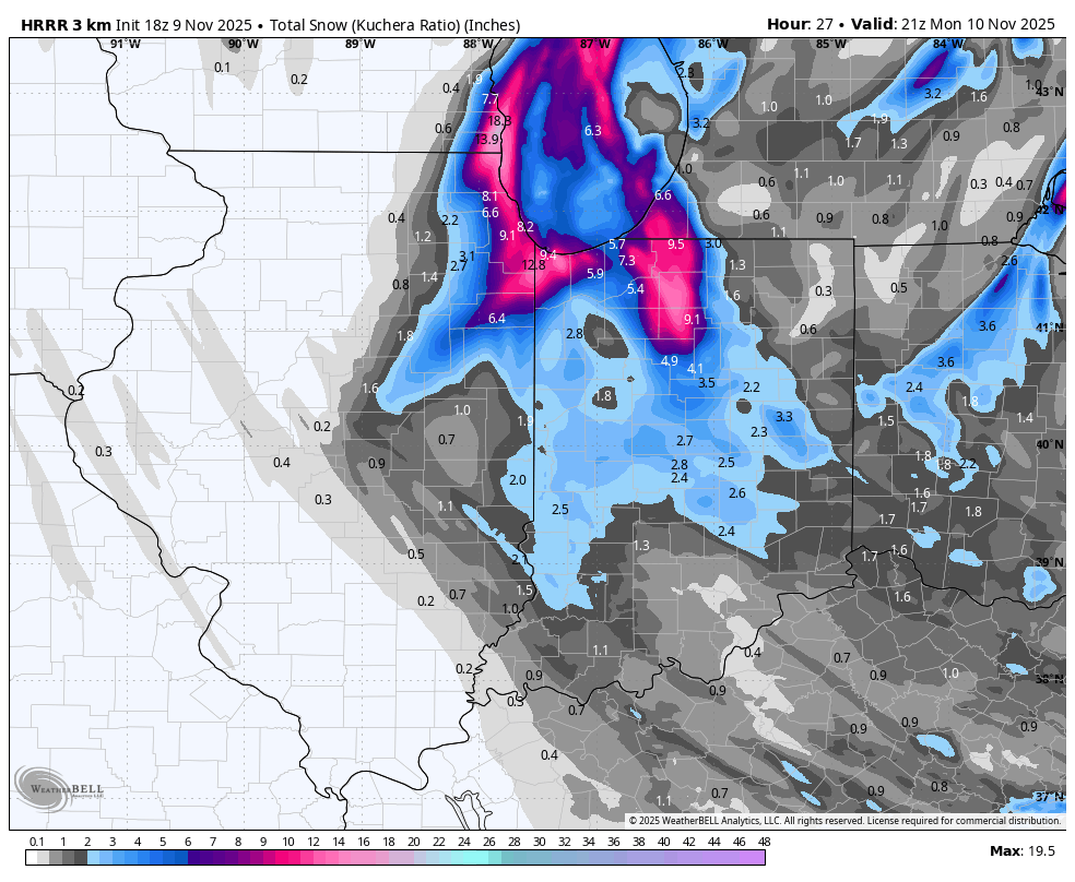
11/8-11/10 First Snow and Lake Effect Event
homedis replied to Geoboy645's topic in Lakes/Ohio Valley
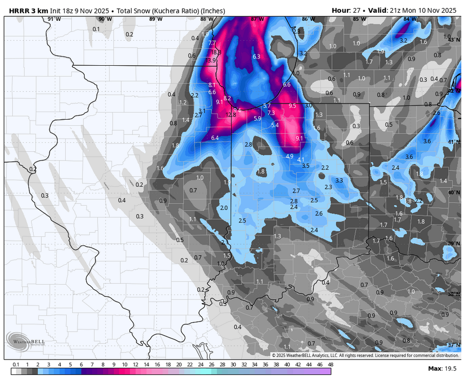
HRRR is liking Lake Co., IL & Kenosha a little more with the 18z. -

2025-2026 Fall/Winter Mountain Thread
Buckethead replied to Buckethead's topic in Southeastern States
KMRX has upgraded the WWA's to a WSW just over the border. Sent from my SM-S908U using Tapatalk -

11/8-11/10 First Snow and Lake Effect Event
weathafella replied to Geoboy645's topic in Lakes/Ohio Valley
Nice to see snow in the air at the giants/bears game. My daughter works downtown and lives in Logan Square. I bet she’ll have a lot more at work near the lake vs home. Meso effects are so unpredictable. I was visiting in July and we went to dinner in the west Loop area one night and got 3” of rain in a fairly short time. 5 miles north nothing. -
Made that post yesterday basically saying I wish this setup happened about a month later .
-
I'd love to have a new storm track one of the years. The one of the last decade sucks...not even "higher amounts north and west of the city" exists anymore! I find the fact that there is no clear cause rather annoying, lol
-
Kuchie not as kind.
.thumb.png.2ea0cc381458f9c9f33d7e03b913664b.png)
-
It'll be gone by 0z unfortunately.
-
Just looked! Me too!!!
-
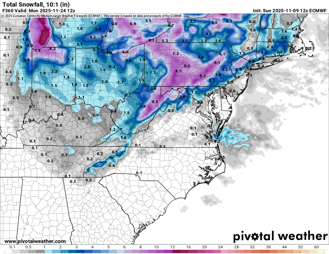
I'll take what the 12z Euro is selling at 204 please Alex
-

11/8-11/10 First Snow and Lake Effect Event
Jebman replied to Geoboy645's topic in Lakes/Ohio Valley
Gonna need to dig out, too lol. ENJOY! -
Monitor but dont take the bait...once cycle and EPS has nil. Probably a tease but with the block as it is possibilities will present, but will they ever express as reality this month?
-
imagine unironically posting anything from that windbag grifter Rogan lol !
-
No thread attm for 1) the Tue wind advisory potential 10A-10P (marginal since the 850 jet doesn't increase past 40 kt til near sunset) and 2) the first flakes of the season at NYC CP ASOS...again hit or miss during Tue morning-early afternoon. Flurries are coming in the exceptionally unstable low level lapse rate to 750MB -momentum transfer from roughly down below 9000' (-12C 850 temp ANOMALY for this early in the season)..therefore mixing near 40 kt, especially late Tuesday and spewing virga/sct flurries/sprinkles into NYC with the BL temp a little too warm to be assured flurries at the CP ASOS but I think it will happen. This in association with the northeast departing 12hr 190M 5H HFallC and the oncoming 210M 5H HRiseC. IE... a high amplitude cold trough aloft getting ready to quickly exit the northeast USA. I saw the CFS comment a couple days ago about multi consecutive snow cycles for the interior NYC subforum tomorrow. I'm not a CFS fan and so I dont look at it very often. I did pay attention to the comment. It's a climate model so I doubt if it has the BL temp handled as well as the standard Global EC/GFS/ECAI. Even the ECAI still lags all other modeling and looks hopeful for cold rain into early Monday afternoon across most of the NYC subforum, but it looks like the BL temp is too warm for wet snow melting on pavement except maybe our nw NJ hills into the Catskills during the midday-afternoon hours, above 1000 feet. Fairly interesting pattern for Nov given the return of the strong 5H Block to eastern Canada-Greenland.
-

11/8-11/10 First Snow and Lake Effect Event
donsutherland1 replied to Geoboy645's topic in Lakes/Ohio Valley
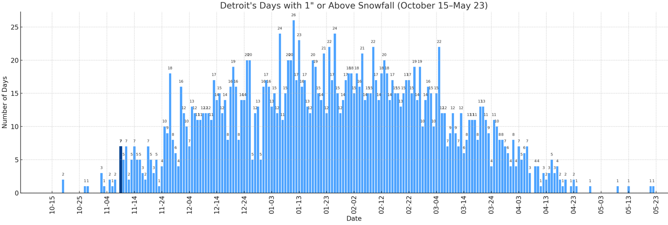
With 1.2" of snow earlier today, Detroit saw 1" or more snowfall for the 7th time on record for November 9. The prior cases for November 9 snowfall of 1" or above are: 1894 2.0" 1913 1.8" 1921 5.3" (daily record; 3rd biggest daily snowfall on record prior to November 15; 8th biggest daily snowfall on record for November) 1933 1.3" 1971 1.6" 2018 1.3" November 9 is the earliest date with 7 or more such snowfalls.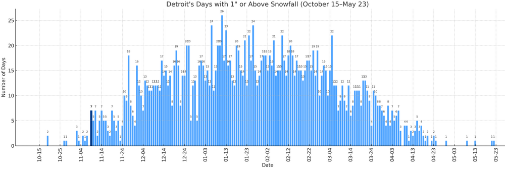
-
@CAPE enjoying this ravens O line performance?
-

November 2025 general discussions and probable topic derailings ...
Brewbeer replied to Typhoon Tip's topic in New England
Just pointing out the hypocrisy, carry on Sprinkling here in Bridgeport, about to ferry over to LI


.png.708b7c6fb29f01623130f80946a75a88.png)