All Activity
- Past hour
-
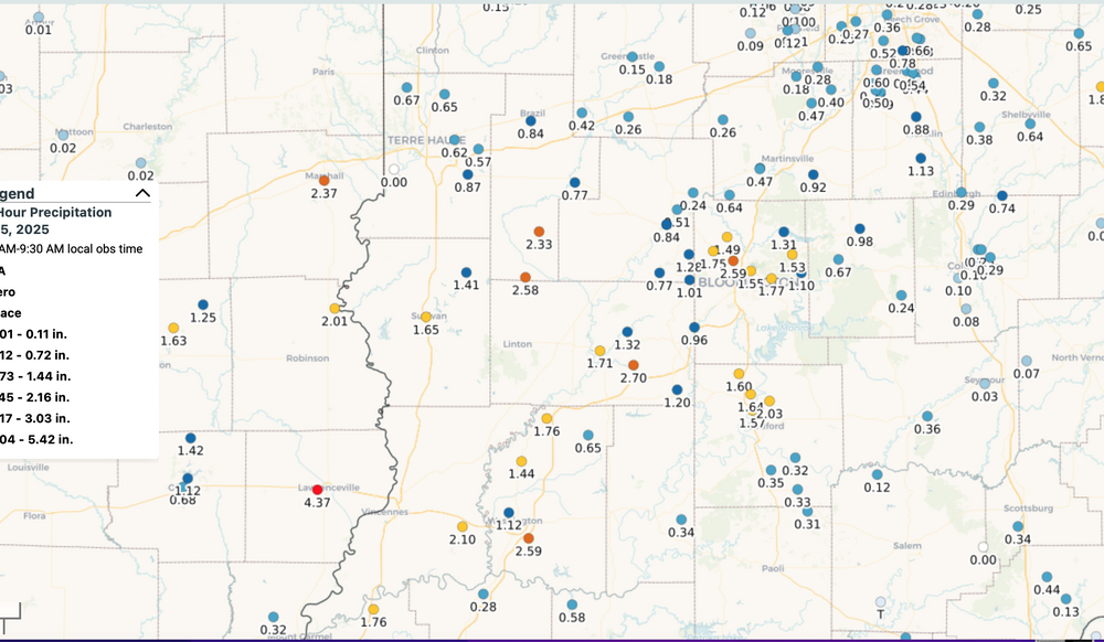
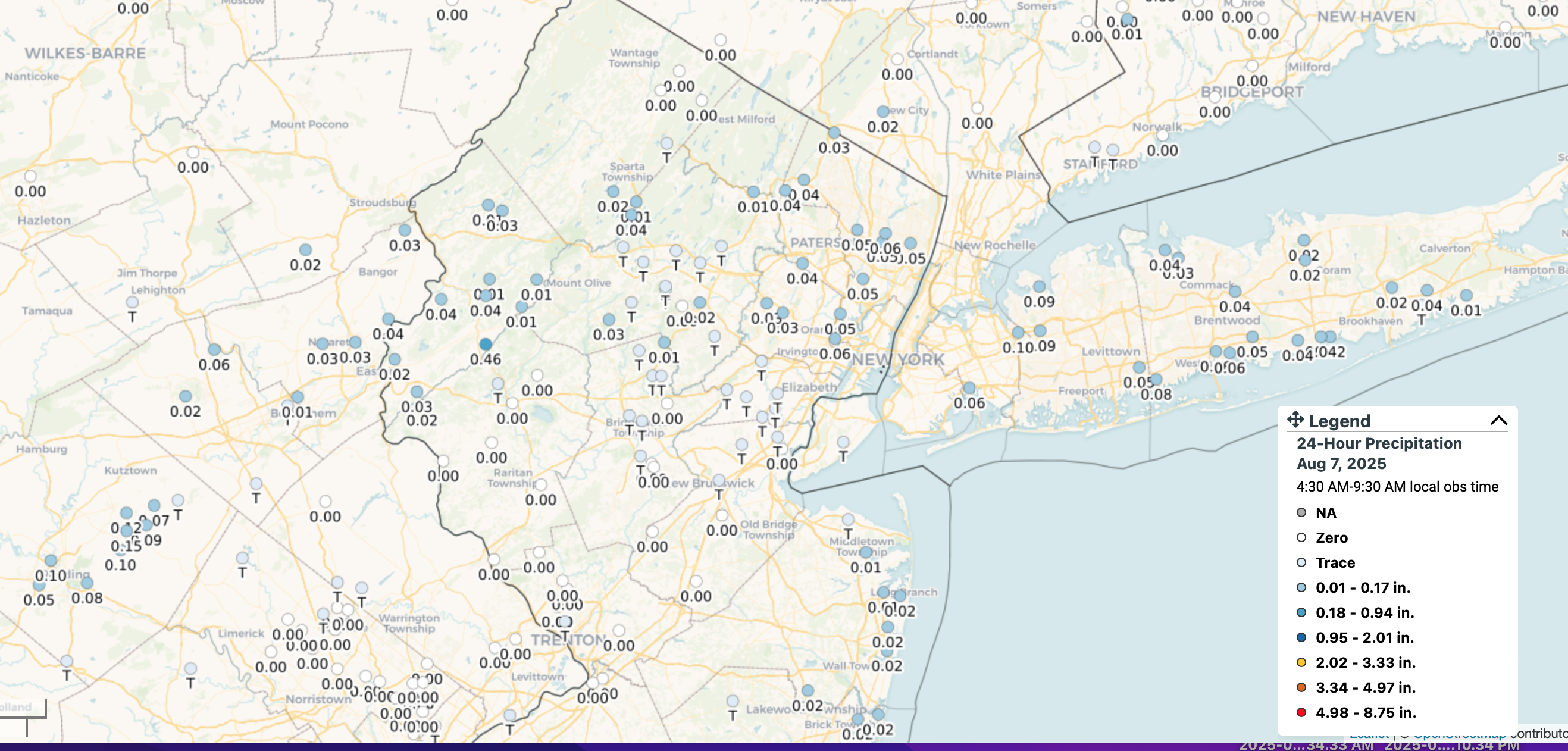
 Modeling issues: Sort of a bust for our no rain last night... ONLY the EPS got it right 24 hours in advance (00z/6 cycle). In the longer range it looked bigger up through NJ/PA (my post on OH Valley low aloft) but GEFS was dry and so many forecasters opted for 20% or less chance yesterday, instead placing the 20% for today. Then as we drew closer to yesterday, all the modeling tended to shrink southward and I gave in to the dry GEFS (my mistake), but alas the EPS still held onto a little, which is what we got up through about 40-41N latitude. See attached graphic. Ohio Valley had isolated 4-5" in w Central Indiana/e Central IL, with some 2"s just e of Cincinnati on the 4th-5th respectively. Then last night we got our minor amounts, mostly evening on previously dismissed chances. I would say pretty deficient modeling for the northern fringe of the ne moving rain areas. CoCoRaHs attached for yesterday here and IN/IL for the 4th.
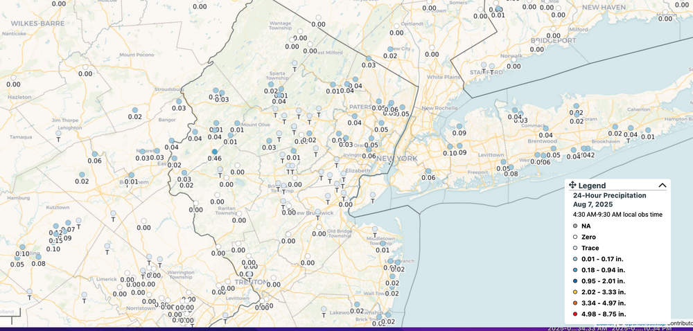
-
Need to check the weather chart to see if it's safe to go outside? Next week maybe not looks brutal
.thumb.png.c0a805d3b9b8a7c740cadc1baa23e4cb.png)
-
Picked up a shocking .27" of rain yesterday. The tiniest cell popped directly over Maytown and dumped. There was zero rain in any direction outside of town...at least in our general area it literally rained only over about a 2 mile area in circumference.
-
Maybe we can build this into early September and get another Labor Day '98 Derecho...but farther south. That one went across NNE right? That wasn't the one where there was the derecho NNE and then through NYC? my memory is fading in my elevated age
-

2025 Atlantic Hurricane Season
LongBeachSurfFreak replied to BarryStantonGBP's topic in Tropical Headquarters
What’s over Chad right now does have down stream implications. If the Sahel were experiencing a drought it would likely lead to a below normal season. Since that’s not the case watching waves in their embriotic state offers a glimpse of activity down the road. Anything more then that, as in locking in 360 hours global runs is pure speculation. -
Still smoky here today but not on the ground. More aloft
-
 I agree. Without the rain, I am sure Central Park's lows would have been several degrees warmer.
 -
Moderators, please get the political crap out of here.
-
I'm ready to not wake up to temps in the 70s. Save that crap for the east coast.
-

TROPICAL WAVE LOCATED IN CHAD, AFRICA (NOT 96L)
GaWx replied to BarryStantonGBP's topic in Tropical Headquarters
The 6Z Euro ens 144 hour (end of run) is more active and quite possibly the most active run yet with this AEW. I count 19 closed sfc lows with 4 of those being sub 1000 mb. This is unfortunately setting up to be a potentially very dangerous system down the road for some land areas and is something the Euro Weeklies have been on top of for the last 9 days. For the Conus, itself, I’ll especially be interested whether or not the MJO is going to be either in phase 2 (inside or outside the circle) or nearby. Model consensus is at least hinting at that possibility.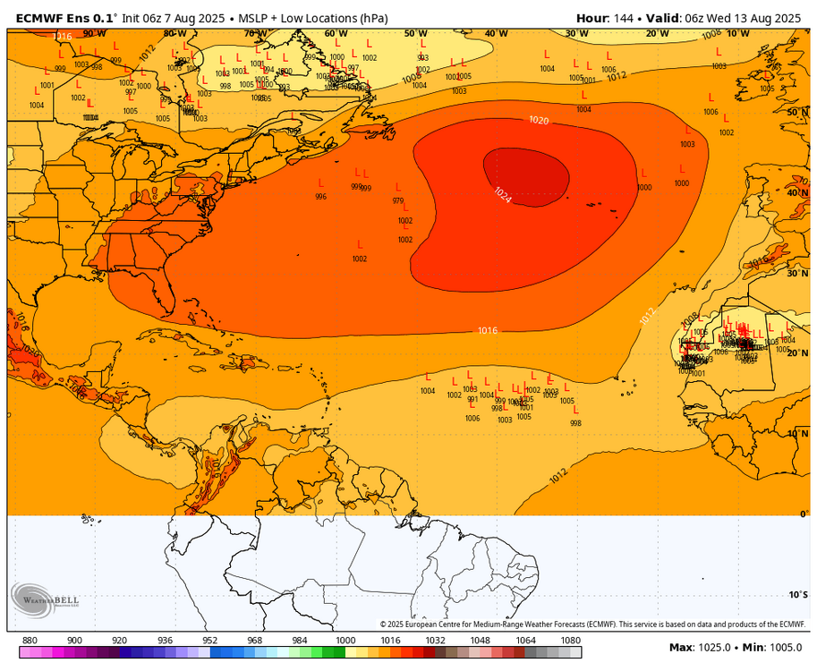
-

2025-2026 ENSO
40/70 Benchmark replied to 40/70 Benchmark's topic in Weather Forecasting and Discussion
We don't need indexes in this new, warmer climate. Just stick a thermo in the piss-pool east of Japan and call it a day. Seriously, though...I do agree that there is a ceiling on our winter potential until that changes. -
Or, I could have just typed this hahaha
-
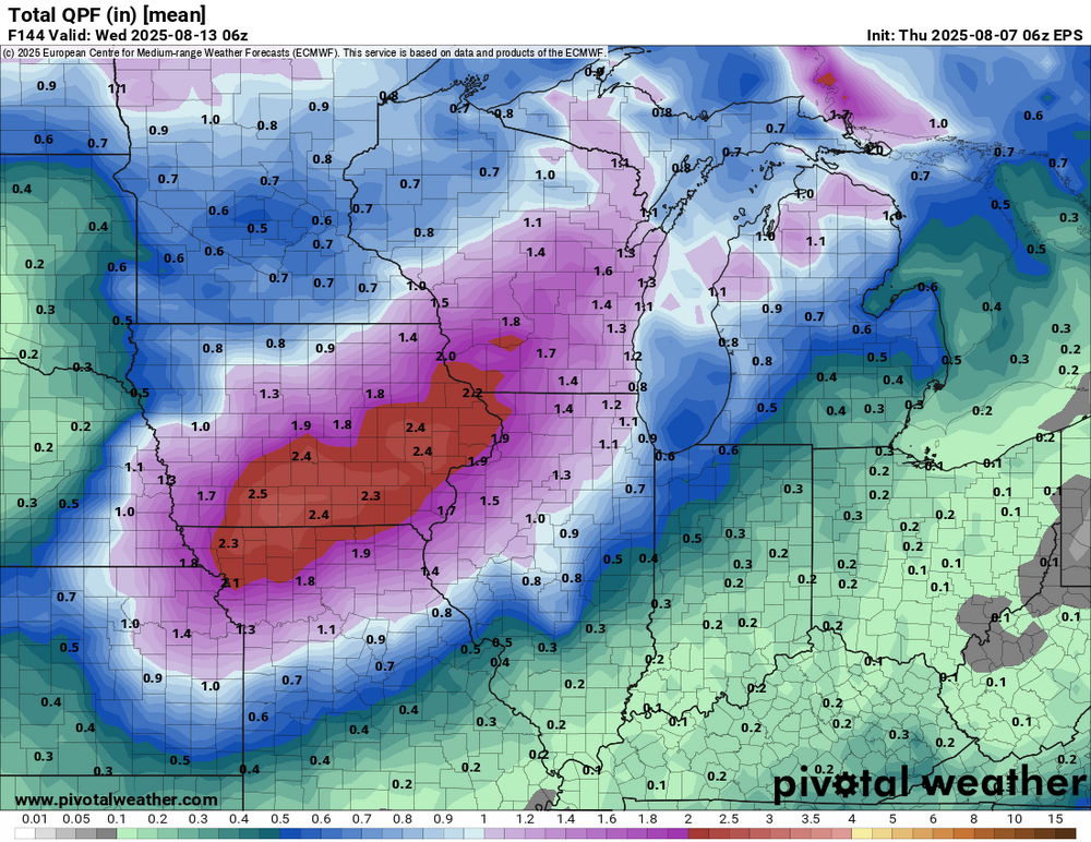
After a brief respite, models are hitting Iowa with another wet period starting this weekend.
-

2025 Atlantic Hurricane Season
Boston Bulldog replied to BarryStantonGBP's topic in Tropical Headquarters
Lots of talk nationally of what may constitute a recession indicator for our economy. Looking around here, seeing some recession indicators for tropical weather comprehension, weather model fluency, and the understanding of the relationship between time and numerical weather prediction. Specifically 6 threads since Chantal, and only a 50mph fish storm in the subtropics to show for it. What are we doing here? I guess the inactive period truly was inactive, despite loud opposition. Might be controversial, but I don’t care what’s over Chad right now. -
Let's go!
-

2025 Atlantic Hurricane Season
nycwinter replied to BarryStantonGBP's topic in Tropical Headquarters
not all recurve irma for example at one point way out in the atlantic it was already north of the islands yet with a strong ridge pressing westward and south irma went wsw for a day or 2. -
I have been saying this for years, but people seem to just want to gravitate towards left verses right. I believe media keeps us in this continued murk to deceive the masses.
-

2025-2026 ENSO
Stormchaserchuck1 replied to 40/70 Benchmark's topic in Weather Forecasting and Discussion
That lack of ice melt pattern leading to -AO is really neat.. I almost want to think that the cold there in the Summer is artificial because of how it snaps the following Winter. I'm leaning toward something not so +nao and -pna. I might not do a seasonal outlook this year because of how close everything is to "neutral". We'll see. -
Let the dog days of August begin.
-
One thing to keep in mind when dealing with these setups which can favor orographic development is the scale of the convection. You need very high resolution models to truly resolve this degree of convection. This is why if you were looking at the GFS (even the 12km or 32km NAM) they showed also little, if any QPF. The HRRR did better at picking up as did the 3km NAM but sometimes with this stuff its just a matter of not having models with high enough resolution to really resolve the potential. I also think some of the activity ended up a bit more widespread just due to extra upward motion from ongoing thunderstorms.
-
2025-2026 ENSO
Stormchaserchuck1 replied to 40/70 Benchmark's topic in Weather Forecasting and Discussion
Because of shortened wavelengths in the mid Summer, July has a +temp correlation with +PNA from ATL to NYC -
That’s such a terrible opinion, I actually feel bad for you.
-

Central PA Summer 2025
Mount Joy Snowman replied to Voyager's topic in Upstate New York/Pennsylvania
No rain here. Low of 63. A beautiful fews days ahead before things turn bigly muggy again next week. -
Yea it’s not the DEI, the illegals, the gays, or the welfare peeps…it’s the socialism for the big corps that steal trillions from taxpayers. Once the majority of Americans come to terms it is not a left vs right but a bottom vs top…we can finally get shit right here. Until then, they will continue to pin neighbors against each other while they collect more and more and more.
-
Just musing over the 2-meter temp products from Pivotal ... wow. No shit! The GFS has something like a 8 consecutive days in the low and mid 90s, with a couple of them tickling a hundred. The Euro has a trough bullying across southern Canada ~ 210 or so hours.. mm, not impossible, but the ensembles are less emphatic with that idea. Despite that potential interruption ( which obviously subject to change at this range anyway ), the model still has multiple days of 90+, even sending 100 this next Wednesday. It may be that what is in store is the greatest heat of the season by virtue of length. That big heat near the tale end of June was short and of course very sweet. The one at the end of July, with record highs at multiple climo sites around S and C NE, was also not exceptionally long. But this looks in the models like the scalars might be 2-3 less, but lasting for a long time. It would win out in bulk....


.png.1664ef91db10ee370f832648ba75ec56.png)


